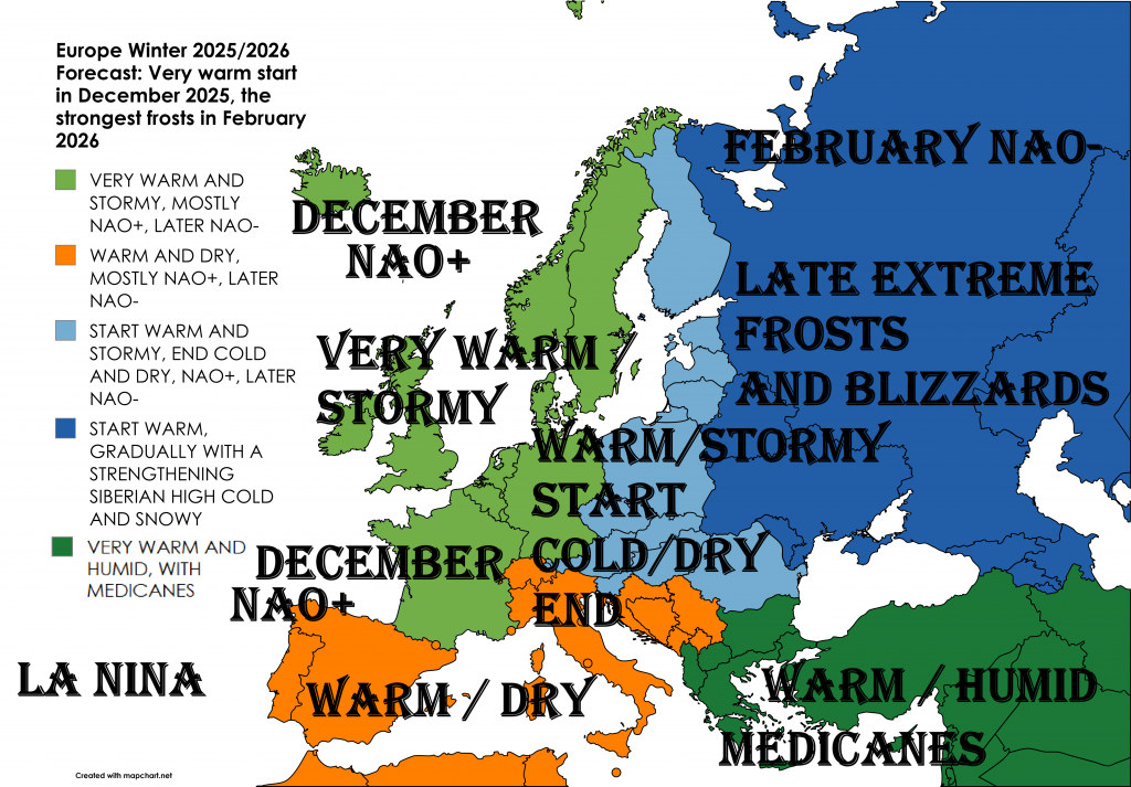
Europe Winter 2025/2026 Forecast: Very warm start in December 2025, the strongest frosts in February 2026
(December 2025 – February 2026)
Based on the NOAA CFSv2 model, May 2025 updates, and global teleconnections (including ENSO, NAO, AO, and others), here’s a regional forecast for winter weather across Europe, with detailed expectations for temperature, precipitation, and potential extremes.
OVERVIEW
Winter 2025/26 in Europe is expected to be largely shaped by a weakening El Niño (transitioning toward neutral), a likely positive NAO and AO at the start of winter (especially December 2025), a possible mid-winter sudden stratospheric warming (SSW) and NAO- in February 2026, and ongoing warm anomalies in North Atlantic sea surface temperatures. The Siberian High and Eurasian snow cover extent will play crucial roles by late winter
Teleconnections such as ENSO, NAO, AO, QBO, and MJO suggest an early winter dominated by Atlantic westerlies and mild temperatures, especially in western and southern Europe. Late winter may feature a pattern reversal with increased risk of cold outbreaks in the east and north.
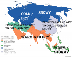
The winter of 2025–2026 is expected to be mild and wet across much of Western and Northern Europe, with more variable and locally cold conditions in Central and Eastern Europe, and warm, dry spells dominating the Mediterranean.
Key drivers:
- Strong positive ENSO (El Niño weakening into neutral)
- Positive NAO and AO forecast early in winter
- Possibility of mid-winter sudden stratospheric warming (SSW)
- Unusually warm SSTs in the North Atlantic
- Stronger-than-average Polar Vortex through December
- Developing Siberian High late in January and February
REGIONAL OUTLOOKS
1. WESTERN & NORTHERN EUROPE
(UK, Ireland, France, Benelux, Denmark, Scandinavia)
Temperature: Above-normal across all months, with anomalies strongest in December (+2 to +3°C). Zonal flow and mild Atlantic air will dominate. Cold spells are unlikely until late February.
Precipitation: Wetter than normal, particularly in western UK, coastal Norway, and northern France. Frequent Atlantic lows will bring rain and strong winds.
Snow & Extremes: Snow confined to higher ground (Scottish Highlands, Norwegian mountains). Risk of windstorms and localized flooding in December and January.
2. CENTRAL & EAST-CENTRAL EUROPE
(Germany, Poland, Czechia, Slovakia, Hungary, Austria, Romania)
Temperature: Near-normal to slightly below normal in late January and February. December will be milder than average due to westerlies. Potential cold outbreaks from Siberia in February.
Precipitation: Normal to above-normal in Alpine and Carpathian zones; lower amounts in lowland areas. Snow more frequent in January and February.
Snow & Extremes: Good snowfall in Alps and Carpathians. Potential for frost periods and freezing fog in basins. Coldest conditions likely in February.
3. EASTERN EUROPE & WESTERN RUSSIA
(Ukraine, Belarus, Moldova, western Russia)
Temperature: Mild start, increasingly cold by mid-to-late winter. Possible SSW-induced polar vortex disruption may trigger prolonged deep freezes in February.
Precipitation: Average to slightly above-normal, particularly in Dnieper basin and Black Sea regions. Increased snow cover toward February.
Snow & Extremes: Snow accumulation expected from January onward. Belarus and Ukraine may face extended cold spells and snow-covered periods in February.
4. NORTHERN EUROPE & BALTIC REGION
(Finland, Sweden, Norway, Estonia, Latvia, Lithuania)
Temperature: Mild in December, with coastal warmth in Norway and Sweden. Turning colder in February. Baltic interior and Finland could see Arctic blasts.
Precipitation: Above average in western Norway. Normal or slightly below elsewhere. Snow more likely in late winter.
Snow & Extremes: Deep snowpack in Finland and inland Sweden likely by February. Coldest spots could see -30°C in metropolitan areas in late season if high pressure dominates.
5. SOUTHERN EUROPE & MEDITERRANEAN
(Spain, Portugal, Italy, Balkans, Greece)
Temperature: Warmer than average across all three months. Frequent ridging from the subtropics. Iberia and southern Italy may feel like early spring.
Precipitation: Drier than average in Spain and Portugal. Near normal or slightly below in Italy and western Balkans. Eastern Balkans and Greece may experience heavy rain in February.
Snow & Extremes: Limited snow outside mountains. Alps and Dinaric Alps may benefit from late-January snow events. Medicanes possible near Greece or southern Italy.
CLIMATE DRIVERS & TELECONNECTIONS SUMMARY
- ENSO: Weakening El Niño → neutral → possible La Niña late spring. Early winter mild, late winter pattern change possible.
- NAO/AO: Positive early winter = stormy, mild west; potential drop in February = cold east/north.
- QBO: Westerly phase reinforces strong polar vortex early; minor influence late winter.
- MJO: Active phases in December could boost storm activity.
- SSW Risk: Moderate. If occurs in January, could bring February Arctic outbreaks.
- SSTs: NE Atlantic and Barents warm = enhanced storm energy.
- Siberian High: Strengthening in January; critical for Eastern and Central Europe.
- AMO: Warm phase; intensifies Atlantic moisture flux.
- Polar Vortex: Strong through December; weakening in late January possible.
PROGRESSION MONTH-BY-MONTH (Summary)
- December: Warm and wet in West, dry and mild in South, delayed snow.
- January: Transition month; western ridge holds but signs of cold spreading east.
- February: Possible pattern reversal; polar outbreaks into East and Central Europe. Drier West, snowier East/North.
FINAL NOTES
This winter is expected to be heavily front-loaded with warmth, followed by potential disruptions later. Confidence is highest for a mild, wet December in Western Europe and a colder-than-average February in Eastern and Northern Europe, depending on stratospheric events. Snow prospects improve after mid-January, especially in mountainous areas.
Summary
According to NOAA’s June 2025 model guidance:
- Western & Southern Europe: Likely to experience mild, wet (west) or dry (south) conditions.
- Central Europe: Near-normal winter, with risk of cold snaps and moderate snowfall.
- Eastern & Northern Europe: Watch for Arctic outbreaks, especially in February, possibly triggered by stratospheric warming events.