
June 9, 2025 — A renewed surge of warm, moist air from the Gulf of Mexico, combined with an upper-level disturbance, is setting the stage for a multi-day period of thunderstorms and severe weather across the Southeastern United States. From Louisiana and Mississippi through Georgia, Alabama, the Carolinas, and into parts of Florida, the region should prepare for heavy rain, damaging winds, and the threat of isolated tornadoes.
🌦️ Atmospheric Setup
An amplifying upper-level trough is diving southward across the central U.S., helping to destabilize the atmosphere over the Southeast. At the same time, high dew points and daytime heating are contributing to widespread atmospheric instability, especially in areas where sunshine persists before storms form.
A frontal boundary stalled near the Gulf Coast will act as a focus for thunderstorm development, with low-level wind shear and high CAPE values indicating the potential for supercells and organized storm clusters.
⚠️ Severe Weather Outlook
According to the Storm Prediction Center (SPC), parts of the Southeast are under a Slight Risk (Level 2/5) for severe storms through Tuesday and potentially into Wednesday.
Main Hazards:
- 🌬️ Damaging straight-line winds (50–70 mph gusts)
- ☔ Torrential rainfall with flash flood risk
- 🧊 Large hail (up to 1 inch or more in isolated areas)
- 🌪️ Isolated tornadoes, especially with any discrete supercells
The greatest tornado threat will likely occur from central Mississippi into western Alabama, where wind shear and helicity are most favorable.
📍 State-by-State Breakdown
- Mississippi & Alabama: Scattered severe storms with damaging winds, flash flooding, and tornado potential.
- Georgia: Numerous afternoon and evening storms with a localized flood threat in urban areas like Atlanta.
- South Carolina & North Carolina: Clusters of storms could organize into an MCS (mesoscale convective system), bringing widespread rain and some damaging wind gusts.
- Florida Panhandle: Heavy tropical downpours, lightning, and gusty winds with low but nonzero tornado risk.
🌧️ Rainfall Totals & Flooding Risk
Over the next 3–5 days, rainfall totals may reach:
- 2–4 inches common across much of the region
- Locally 5+ inches, especially in areas that receive training storms
Urban flooding and small-stream flooding are real concerns, particularly in low-lying and poorly drained areas. The Weather Prediction Center (WPC) has issued Marginal to Slight Risk outlooks for excessive rainfall across parts of the region.
🛰️ Tropical Moisture Connection?
While no tropical storm is expected to form imminently, deep tropical moisture from the Gulf of Mexico and western Caribbean is feeding into this system. Should low pressure consolidate along the stalled front, a subtropical or weak tropical low could emerge later in the week, though current models show only minimal development.
🛑 What Residents Should Do
- Monitor local weather alerts and NOAA warnings
- Be prepared for power outages and flooded roads
- Have a plan in place in case of tornado warnings, especially in mobile homes or rural areas
- Avoid driving through flooded roadways — “Turn around, don’t drown”
🔄 Outlook Into the Weekend
Storm activity is expected to persist into Thursday and Friday, especially in Florida, Georgia, and the Carolinas, before high pressure builds in from the west. However, afternoon storms may continue in typical summer-like pattern across the Southeast through mid-June.
Stay tuned for daily updates from SPC, NWS, and local meteorologists as this dynamic pattern unfolds across the Southeast.

Storm Forecast for Southeast. Source: usatoday.com
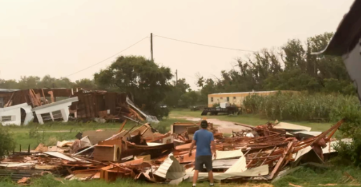
Illustration picture. Source: Tweet above.


