Tornado Surge in 2025: Texas, Illinois, Missouri, and Mississippi Top the List
As of early June 2025, the United States has entered one of its most turbulent tornado seasons in recent memory. With over 1,000 tornadoes confirmed across the country, this year’s severe weather activity has outpaced typical seasonal averages — and four states are leading the count with over 100 tornado reports each.
Texas: Still Tornado Capital of the U.S.
Texas once again holds its reputation as the tornado capital of America, topping the list with 109 tornado reports so far this year. The Lone Star State has seen numerous outbreaks, particularly throughout the spring months, with supercells producing long-track and destructive twisters.
Illinois and Missouri: Surprising Surge to the Top
Close behind Texas, both Illinois and Missouri have logged 105 tornado reports each. This marks a dramatic increase for Illinois, which was not in the top five for tornado counts at the same point last year.
Missouri, which was in the top five in 2024 as well, continues to see persistent activity.
Mississippi: Reaching Triple Digits
Mississippi rounds out the list of four states with 100 preliminary tornado reports, reflecting a particularly active early spring. Many of these tornadoes occurred during nocturnal outbreaks, a dangerous feature of southern severe weather seasons. Storm systems moving across the Southeast have repeatedly triggered conditions favorable for rotating storms, with Mississippi taking the brunt of several large-scale convective events.
Comparison with 2024 Tornado Rankings
This year’s tornado leaderboard presents a shift from May 2024, when the top five tornado-prone states were:
- Texas
- Iowa
- Nebraska
- Missouri
- Oklahoma
The 2025 season has seen Illinois and Mississippi leap into the top tier, while Iowa and Nebraska — traditionally high-ranking during tornado season — have experienced less activity due to shifts in jet stream dynamics and storm track placement. Oklahoma, while still active, has so far fallen just outside the top five.
Why the Change?
Meteorologists attribute the shifting pattern to several key atmospheric ingredients in 2025:
- A persistent trough over the western U.S. has kept moisture and instability flowing into the Midwest and Southeast.
- Above-average Gulf moisture has fueled explosive thunderstorm development.
- Stronger-than-usual jet stream winds have enhanced rotation in storms across the Mississippi Valley and Midwest.
This season’s broad spatial distribution of tornado activity is unusual, spreading more evenly across regions that are typically less dominant in tornado frequency at this point in the year.
Looking Ahead
With several weeks left in peak tornado season, and hurricane season just beginning, residents across tornado-prone areas are advised to stay alert. The National Weather Service and meteorologists nationwide emphasize the importance of having multiple warning methods and knowing where to shelter — especially in states like Illinois and Mississippi, where early-season complacency can lead to higher risk.
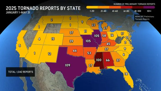
Tornado map JAN – MAY 2025. Source: https://www.accuweather.com/en/severe-weather/4-states-stand-out-in-this-1000-tornado-season/1780794
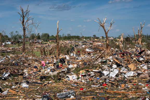
A debris after tornado in London, Kentucky, on May 17th 2025. Source: Reuters.


