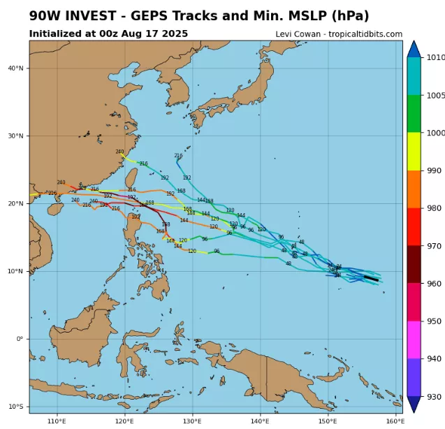
Invest 90W has emerged in the western Pacific Ocean, drawing attention from meteorologists as it begins its long journey westward toward the Philippines, Taiwan, and China. As of 12:00 UTC, August 17, 2025, the system was centered near 8.2°N, 154.9°E, with maximum sustained winds of 20 knots (37 km/h) and a minimum central pressure of 1008 mb.
Though weak at present, Invest 90W is embedded within the monsoon trough and is positioned over very warm sea surface temperatures (30–31 °C) in the central-western Pacific. The storm’s low-level circulation is broad but poorly defined, with clusters of deep convection flaring intermittently around the western semicircle. The radius of circulation has not yet been clearly established, but satellite scatterometer data suggest weak winds extending outward 150–200 km from the center.
The system is in a marginally favorable environment for further development. Vertical wind shear (15–20 kt) is currently inhibiting organization, displacing convection from the center. However, upper-level outflow remains good to the north, providing some ventilation that could aid intensification if shear relaxes.
Meteorological Context
- Current Winds: 20 kt sustained, occasional squalls up to 25 kt.
- Central Pressure: 1008 mb, weakly defined circulation.
- Sea Surface Temperatures: 30–31 °C, well above average and highly supportive of tropical development.
- Moisture: High precipitable water (>60 mm), fueling strong convective bursts.
- Environmental Setup: Located south of the subtropical ridge axis, steering currents are expected to drive 90W west-northwest over the next 5–7 days.
Forecast and Threats
Numerical models suggest that Invest 90W could slowly organize into a tropical depression in the coming days. If consolidation occurs, the system could intensify as it tracks closer to the Philippines by late week. The Philippine Atmospheric, Geophysical and Astronomical Services Administration (PAGASA) is monitoring for potential impacts in the eastern Visayas and Luzon.
Should the system survive its passage through the Philippine Sea, later model runs bring it near Taiwan and eventually the southeastern coast of China, possibly as a stronger tropical storm. However, uncertainty remains high due to its broad structure and current lack of a defined radius of maximum winds.
The primary hazards in the short term will be heavy rainfall and squally thunderstorms across Micronesia and later the central and eastern Philippines. Mariners in the Philippine Sea and Luzon Strait are urged to monitor developments as seas build to 2–3 meters in advance of the circulation.
Even in its formative stage, Invest 90W highlights the classic threat of Pacific systems: weak in wind, yet capable of extreme rainfall and long-term development into a more organized storm that could threaten millions across Southeast and East Asia.
Source: https://www.tropicaltidbits.com/storminfo/#90W


