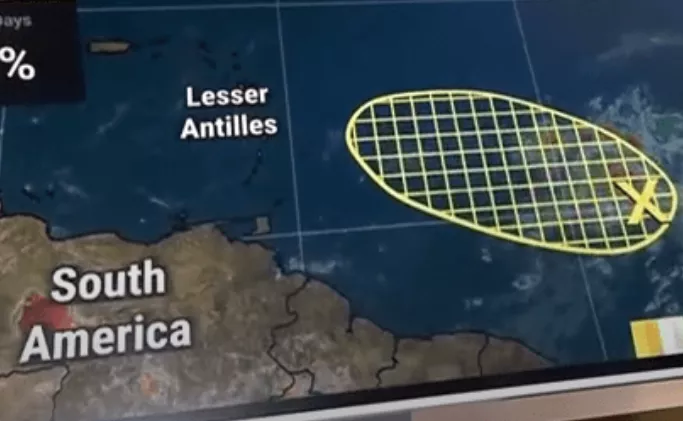
The National Hurricane Center has designated a broad area of low pressure roughly 900 miles east of the Lesser Antilles as Invest 94L. While current odds for it developing into a tropical cyclone remain low, meteorologists emphasize that environmental changes over the next day or two could foster some strengthening as it drifts northwestward toward the Caribbean.
Invest 94L is currently disorganized, with scattered thunderstorms and modest mid-level convection. Showers are expected to reach the Lesser Antilles by mid-week, potentially causing localized flooding and elevated rip current risk—regardless of whether it becomes a named storm. The system is poised to navigate along the southern edge of the Bermuda High, with wind shear increasing as it nears the islands—factors that could limit intensification.
Forecast models offer diverging signals: some indicate marginally favorable conditions due to brief dips in atmospheric shear, while others point to encroaching dry Saharan air that could suppress further development. Although unlikely to achieve tropical-storm status, Invest 94L remains a rainmaker poised to impact the Lesser Antilles around Thursday or Friday.
Invest 94L does not currently threaten the U.S. mainland, but its rain bands could retrace through its remnants, feeding into a tropical moisture plume that may bring unsettled weather to the Gulf Coast later in the week.
Key takeaways:
- Invest 94L is a low‐development‐probability system in the central Atlantic.
- Heavy rainfall and flood risk are the primary concerns for the Lesser Antilles.
- Wind shear, dry air, and limited time over warm water are suppressing intensification.
- Keep monitoring as its remnants could enhance Gulf Coast rainfall.
Illustration picture: The Weather Channel


