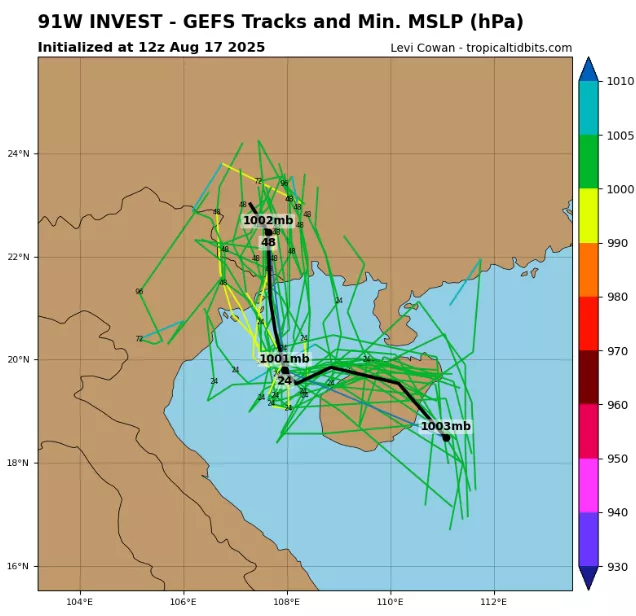
Invest 91W has reached the shores of Vietnam and southern China, delivering heavy rainfall, gusty winds, and widespread disruption despite not achieving full tropical storm classification. As of 12:00 UTC on August 17, 2025, the system was analyzed near 17.9°N, 111.0°E, with maximum sustained winds of 25 knots (45 km/h) and a minimum central pressure of 1002 mb.
Although relatively weak in wind strength, its broad cyclonic circulation has tapped into abundant South China Sea moisture, enhancing rainfall across the region. Satellite imagery has revealed deep convective bursts clustered on the western and southern quadrants of the system, where sea surface temperatures (SSTs) remain at 29–30 °C—well above the threshold for tropical development.
The storm’s low-level circulation center (LLCC) remains elongated, with an asymmetric structure caused by moderate vertical wind shear (10–15 kt). This shear has displaced convection westward toward Vietnam’s coastline. Despite the disorganization, the wide fetch of winds is driving strong onshore flow, raising the risk of localized storm surge and wave heights of 2–3 meters along Hainan Island and the Gulf of Tonkin.
Meteorological Highlights
- Winds: Peak sustained winds at 25 kt, with localized squalls up to 35 kt.
- Pressure: Central pressure at 1002 mb, environmental pressure near 1006–1008 mb, indicating only a weak gradient.
- Moisture Environment: High precipitable water values (>65 mm) across the Gulf of Tonkin, supporting extreme rainfall efficiency.
- Rainfall Forecast: Totals of 200–300 mm likely in northern Vietnam (Haiphong, Quang Ninh, Thanh Hoa) and southern China (Guangdong, Guangxi, Hainan) within 48–72 hours.
- Flood Risk: Flash floods and landslides expected in Vietnam’s northern highlands and southern China’s mountainous areas.
- Model Guidance: Forecast consensus suggests continued northwest drift at 10–12 km/h, with landfall along the Vietnam-China border region late August 17 into early August 18. Rapid weakening inland is expected, but with residual monsoon enhancement causing extended rainfall into Laos.
The primary hazard remains rainfall, not wind. The slow-moving nature of Invest 91W increases the threat of prolonged downpours, capable of overwhelming rivers and triggering dam overflows. Coastal areas of Haiphong and Hainan Island already report flooded streets and suspended ferry services, while fishing fleets remain in port due to rough seas.
Though only designated an Invest system and not yet named, 91W underscores that weak tropical cyclones can inflict damage equal to stronger storms if their rainfall footprint is broad and slow-moving. Emergency agencies in Vietnam and China remain on high alert as monsoonal moisture combines with 91W’s circulation, extending hazardous weather far beyond its center.
Source: https://www.tropicaltidbits.com/storminfo/#91W


