Winter 2025/2026 Forecast for Europe: From Very Warm to Extremely Cold (from NAO+ to NAO-) +30 MAIN TELECONNECTIONS

A Winter Written by Teleconnections
The approaching Winter 2025/2026 is poised to be a season of contrasting extremes across Europe, where stormy Atlantic influences clash with Siberian cold surges and Mediterranean weather systems. Unlike winters that follow a simple linear pattern, this year’s outlook is governed by an unusually complex interplay of teleconnections: a developing La Niña, a potentially weakening polar vortex, and the oscillating phases of the North Atlantic Oscillation (NAO) and Arctic Oscillation (AO). Add to this the influences of Eurasian snow cover, blocking highs over Greenland and Scandinavia, and feedbacks from ocean–atmosphere circulation, and Europe is looking at a winter that may very well deliver record-breaking episodes of warmth, flooding, snowstorms, and cold waves.
ENSO and the Global Ocean Background
The ongoing La Niña in the Pacific Ocean is the first global driver to consider. La Niña winters typically energize the Atlantic jet stream, bringing a stormy, mild, and wet start to the season for western Europe, including the British Isles, France, and Iberia. Yet history also shows that as winter progresses, La Niña tends to interact with other teleconnections to favor Greenland blocking events. When this occurs, the stormy Atlantic flow weakens, and Arctic air masses from Siberia spill westward into central and eastern Europe. Thus, La Niña sets the stage for a two-phase winter: first, an Atlantic-dominated December, and second, a continental cold-dominated February.
The Pacific Decadal Oscillation (PDO) and Atlantic Multidecadal Oscillation (AMO) also play background roles. The PDO’s warmer pockets in the North Pacific help intensify downstream storm tracks, while the AMO’s warm phase sustains global storm activity and enhances teleconnections into Europe. These slow-moving ocean signals may not decide daily weather, but they tilt the entire season toward volatility.
NAO and AO: Europe’s Climate Gatekeepers
The North Atlantic Oscillation (NAO) is perhaps the most decisive factor for Europe. In its positive phase, the NAO strengthens the westerly jet stream, delivering mild and rainy winters to western and northern Europe while suppressing cold in the east. In its negative phase, however, high pressure builds over Greenland or Scandinavia, deflecting the jet stream south and unlocking Arctic outbreaks. Current seasonal models suggest a positive NAO for December, transitioning toward negative NAO episodes in January and February. This transition is critical, because it suggests a winter that begins unusually stormy in the west but later evolves into snowy and frigid conditions across the heart of the continent.
The Arctic Oscillation (AO) often mirrors the NAO. A negative AO weakens the polar vortex and destabilizes Arctic air masses, allowing them to escape southward. By late winter, signs point toward a negative AO, meaning higher risk of prolonged cold spells from Scandinavia to the Balkans and central Europe.
Polar Vortex and Sudden Stratospheric Warming Scenarios
Above the troposphere lies the polar vortex, the stratospheric circulation that often dictates whether Europe experiences a mild or severe winter. If the vortex remains strong, westerly flow dominates, keeping Europe mild and wet. But if the vortex weakens—or worse, collapses in a sudden stratospheric warming (SSW)—the result can be severe cold outbreaks across the continent.
Early signals for winter 2025/2026 indicate a weakened vortex, with the possibility of at least one major SSW in January. If such an event occurs, the temperature gradient across Eurasia will flip, and blocking highs over Greenland and Scandinavia will lock in place, channeling cold Arctic air into central and southern Europe. The outcome could be historic February cold, rivaling severe winters of past decades.
Eurasian Snow Cover and the Siberian High
Snow cover across Siberia is a key precursor to Europe’s winter climate. Rapid October snow expansion increases surface albedo, cooling the landmass and strengthening the Siberian High. A robust Siberian High pushes cold air masses westward, often colliding with moist Atlantic systems over central Europe. This recipe produces prolonged cold spells and heavy snowfall events.
For winter 2025/2026, above-average snow cover has already been observed across Siberia, suggesting that the easterly flow into Europe will be stronger than normal. This strengthens the risk of long-lasting cold waves in central and eastern Europe, particularly during January and February.
Atlantic Storm Track and Mediterranean Cyclogenesis
The storm track over the Atlantic will dominate December, delivering frequent low-pressure systems into the UK, Ireland, France, and Iberia. Flood risks in these areas are high, as repeated storms bring persistent rainfall and coastal storm surges. By mid-winter, however, the jet stream is likely to dip southward, creating a favorable environment for Mediterranean cyclogenesis.
This means that Italy, Greece, and the Balkans may face dangerous winter storms, marked by torrential rainfall, heavy snow in the mountains, and even severe flooding events. These Mediterranean lows often transport warm, moist air northward, which then collides with Arctic air spilling south, leading to blizzard conditions in central Europe and the Balkans.
Regional Outlooks Across Europe
Northern Europe (Scandinavia, Baltics): Prolonged cold and snowy conditions, especially from January onward. Norway and Sweden may experience heavy mountain snowfalls, while Finland and the Baltics face harsh Arctic blasts.
Western Europe (UK, Ireland, France, Iberia*): December will be stormy and wet, with frequent Atlantic lows. Later in the season, high-latitude blocking could allow snow and cold intrusions, even into lowland areas of France, Spain, and Portugal.
Central Europe (Germany, Poland, Austria, Hungary, Czechia, Slovakia): A transitional zone, mild and stormy early, but with a high risk of severe February cold waves. Snowstorms could disrupt transport and energy systems across this region.
Eastern Europe (Ukraine, Belarus, western Russia): The coldest region of the continent, with potential for record-breaking Arctic outbreaks in late winter. Persistent snow cover and freezing temperatures may dominate.
Southern Europe (Italy*, Balkans, Greece, Turkey*): Stormy and wet, especially during January–February. Flooding rains and heavy mountain snows are expected, particularly in the Adriatic and Aegean regions.
*on the map described as the driest regions overall
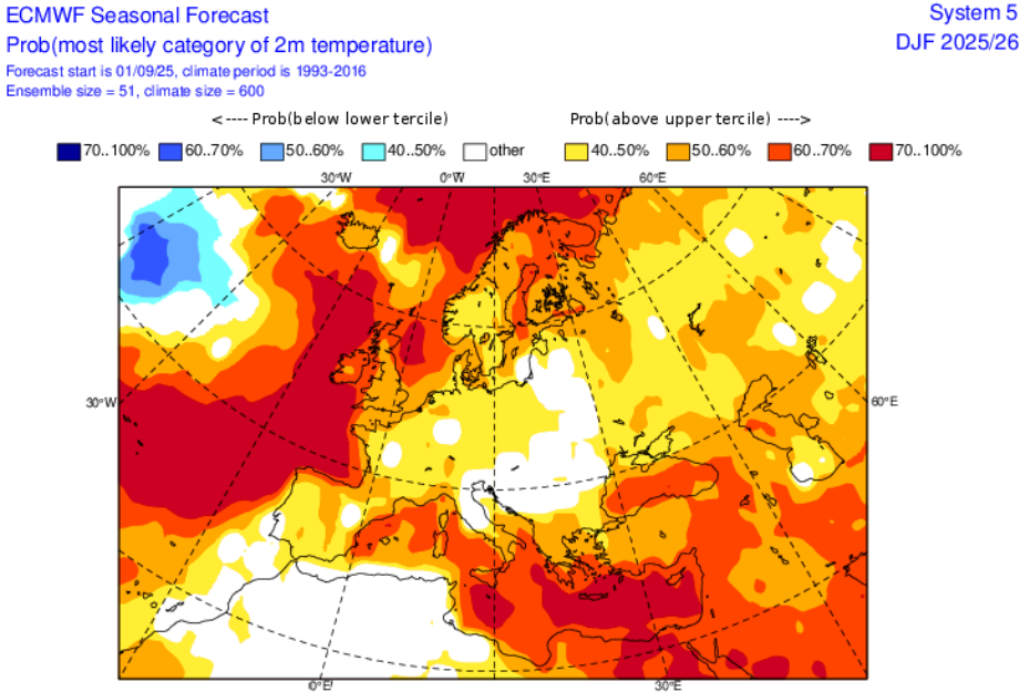
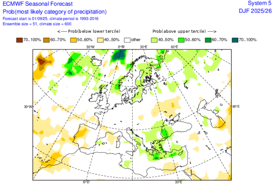
Temperature and Precipitation Anomalies
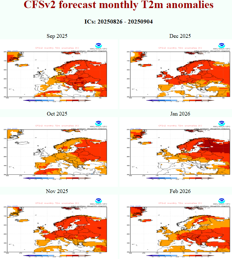
- December 2025: Above-normal temperatures across western Europe, wetter than normal across the UK, France, and Iberia.
- January 2026: Transition month; eastern Europe cools while western Europe remains relatively mild and wet.
- February 2026: Below-normal temperatures dominate most of Europe, with widespread Arctic outbreaks. Heavy snow in central/eastern Europe, drier conditions in western Mediterranean and parts of Iberia.
Extreme Events and Risks
Winter 2025/2026 carries risks of multiple extreme events:
- Storm surges and flooding in the UK, France, and Iberia in December.
- Blizzards and ice storms in central and eastern Europe in January–February.
- Mediterranean flash floods in Greece, Italy, and the Balkans.
- Energy crises from sudden spikes in heating demand during late-winter cold snaps.
Conclusion: A Winter of Contrasts
Europe’s Winter 2025/2026 will not be remembered as mild or severe alone, but as a season of dramatic contrasts. From stormy and wet beginnings in December to the likelihood of historic February cold, the winter will test infrastructure, agriculture, and energy resilience across the continent. Teleconnections—from La Niña to the NAO/AO and the polar vortex—all suggest that Europe should prepare for a volatile and high-impact winter season.
Previous Mkweather Winter 2025/2026 forecast for Europe: https://mkweather.com/europe-winter-2025-2026-forecast-very-warm-start-in-december-2025-the-strongest-frosts-in-february-2026/
Table: 30 Main Teleconnections Influencing European Winter 2025/2026
| # | Teleconnection | Expected Influence on Winter 2025/2026 in Europe |
|---|---|---|
| 1 | ENSO (La Niña) | Strengthens Atlantic jet early winter → stormy west; later enhances Greenland blocking → cold eastern/central Europe. |
| 2 | NAO (North Atlantic Oscillation) | Positive in Dec (wet/warm west); negative later (blocking → Arctic outbreaks in Feb). |
| 3 | AO (Arctic Oscillation) | Weakening in Jan–Feb; negative AO favors polar air intrusions into Europe. |
| 4 | Polar Vortex Strength | Likely weakened; possible SSW → disruption of circulation → prolonged cold waves. |
| 5 | Sudden Stratospheric Warming (SSW) | High chance in Jan; could flip pattern into strong February cold outbreaks. |
| 6 | QBO (Quasi-Biennial Oscillation) | Westerly phase supports stronger vortex early, easterly influence later → destabilization. |
| 7 | PDO (Pacific Decadal Oscillation) | Positive PDO warm pools reinforce storm activity and downstream Atlantic jet. |
| 8 | AMO (Atlantic Multidecadal Oscillation) | Warm phase energizes Atlantic storm track and enhances NAO variability. |
| 9 | Greenland Blocking | Critical for late-winter cold; strong blocking sends Arctic air into Europe. |
| 10 | Scandinavian Blocking | Directs Siberian cold into central/eastern Europe; enhances snowstorms. |
| 11 | Eurasian Snow Cover | Above average → strengthens Siberian High; increases risk of continental cold surges. |
| 12 | Siberian High | Anchors cold pool; stronger highs push frigid air west into Europe. |
| 13 | North Pacific High / Aleutian Low | Impacts downstream wave pattern → influences NAO/AO. |
| 14 | Madden–Julian Oscillation (MJO) | Phases 7–8 enhance blocking; phases 3–4 energize Atlantic jet. |
| 15 | Indian Ocean Dipole (IOD) | Negative → wetter Indian Ocean; slight feedback into MJO + Eurasian jet stream. |
| 16 | Solar Cycle / UV Flux | Lower activity favors more blocking and colder winters in Europe. |
| 17 | Volcanic Aerosols (if present) | Any major eruptions enhance cooling/blocking via stratospheric changes. |
| 18 | Atlantic Tripole SST Pattern | Warm north / cool tropics favors stronger storms into Europe. |
| 19 | North Pacific SSTs (“Blob”) | Influences jet patterns and downstream effects on NAO. |
| 20 | Arctic Sea Ice Extent | Low sea ice → enhanced Arctic amplification → destabilizes vortex. |
| 21 | North Atlantic SSTs | Warm anomalies support storm track shifts; cold anomalies enhance blocking. |
| 22 | Mediterranean SSTs | Warmer → stronger cyclogenesis, more floods and snowstorms in south. |
| 23 | Black Sea SSTs | Warm anomalies feed heavy snowfalls in Balkans, Turkey. |
| 24 | Barents–Kara Sea Ice/SST | Ice loss → higher geopotential anomalies → colder Eurasian winters. |
| 25 | Eurasian Soil Moisture | Dry autumn → stronger Siberian cold; wet autumn dampens extremes. |
| 26 | Tibetan Plateau Snow Cover | Enhanced cover supports stronger winter monsoon → colder Europe. |
| 27 | Stratospheric–Tropospheric Coupling | Weak coupling → unpredictable vortex breakdowns. |
| 28 | Jet Stream Waviness | More meanders → stronger cold plunges into Europe. |
| 29 | Atmospheric Rivers (from Atlantic) | Intensify storms and floods in western/southern Europe. |
| 30 | Anthropogenic Climate Change Trend | Warmer background climate increases storm energy and precipitation extremes, but cold waves still possible due to blocking. |
MKWEATHER WINTER 2025/2026 FORECAST FOR EUROPE

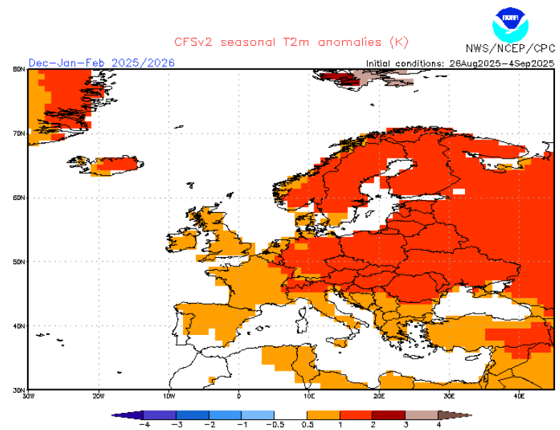
Source: https://www.cpc.ncep.noaa.gov/products/CFSv2/CFSv2_body.html

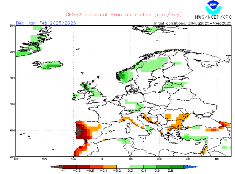
Source: https://www.cpc.ncep.noaa.gov/products/CFSv2/CFSv2_body.html


17 thoughts on “Winter 2025/2026 Forecast for Europe: From Very Warm to Extremely Cold (from NAO+ to NAO-) +30 MAIN TELECONNECTIONS”
Comments are closed.