The storms in the US are affecting millions, Gulf coast is waiting tropical storm, Hawai possible hurricane + heatwave and fires update (+3 VIDEOS)

Situation in the US and Canada is becoming more and more extreme. This week, tropical air will expand over the whole territory of US and T-storms are farthest bothering many states. In addition, Gulf coast is expecting a tropical storm during the next days /https://www.accuweather.com/en/hurricane/caribbean-gulf-coast-on-alert-for-tropical-development-this-week/779403/, Hawai is waiting possible hurricane /https://www.severe-weather.eu/tropical-weather/hurricane-douglas-pacific-mk/?fbclid=IwAR2YHBMIaCxH0ApB7JmQYr4ed7ZTLJDT1K0fxutCKm7insY0NvEdiqRvwI0/ and in California persists a wildfires. Hot and stormy weather hit southern parts of Canada too, but in Wednesday and Thursday will be very hot in Nunavut. Coldwave is only in the NW Canada and Alaska expected /watch our warnigns for the US and Canada: https://mkweather.com/warnings/; https://mkweather.com/warnings-2-day/; https://mkweather.com/warnings-3-day//. To the Midwest and Northeast heatwaves will return till end of current week. The most severe T-storms are in Great Lakes area in Tuesday and Tuesday-Wednesday night and in Northeast in Wednesday expected.
We are bringing a videodocumentation from hit regions in last days from WeatherNation FB page – first video is from Ohio, server mentioned, that the most severe storms hit Kansas, Missouri and Illinois during Monday. Second video is from St. Louis, Missouri from Monday´s evening, the city was hit by severe lighting. Third video is from California wildfire area.
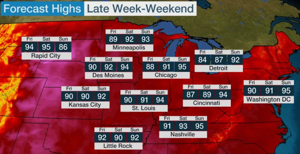
Monday´s temperature highs were finally 102°F/+38,9°C in Macon, Georgia, 100°F/+37,8°C in Baltimore and Norfolk, 99°F/+37,2°C in Washington D.C. and 97°F/+36,1°C in New York. In Sunday, Washington D.C., Chicago or in Saturday Rapid city are waiting 95°F/35°C.
Severe storm in Ohio, Monday, morning /WeatherNation FB


Our warnings for US and Canada, Tuesday-Thursday 21.-23.7.2020 /https://mkweather.com/warnings//


