In October, has never been so cold in the USA! 220-years (all-time) records overcame! In November, Indian summer in outlook!
So brutally cold in October has never been in densely populated areas of the US territory from the beginning of meteorological measurements, minimally since year 1800!
Abnormally cold weather over central and southern parts of USA is coming from extreme cold Canada, where temperatures has dropped in northern parts below -30°C / -22°F (Eureka, -30,5°C / -22.9°F on Monday, 26. October 2020) and up to -27,5°C in southern lower elevated parts (Val Marie, Saskatchewan, 785 MASL on Monday) together with negative phase of Arctic Oscillation (AO-), Negative phase of ENSO (La-niňa), very active late Atlantic hurricane season (wet Madden Julian Oscillation phase, MJO-), transition into easterly phase of Quasi Bienale Oscillation (QBO-), after absolute minimum of 24th Solar cycle and after second record-breaking Arctic sea ice anomaly in early autumn 2020.
In Casper, has been measured -22,2°C / -8.9°F on Monday, with overcoming of very old record /https://mkweather.com/2020/10/23/arctic-days-will-come-in-october-usa-under-record-early-snowfall-with-200-year-october-frosts// -20,6°C / 5°F from 19. century /electroverse.net/.
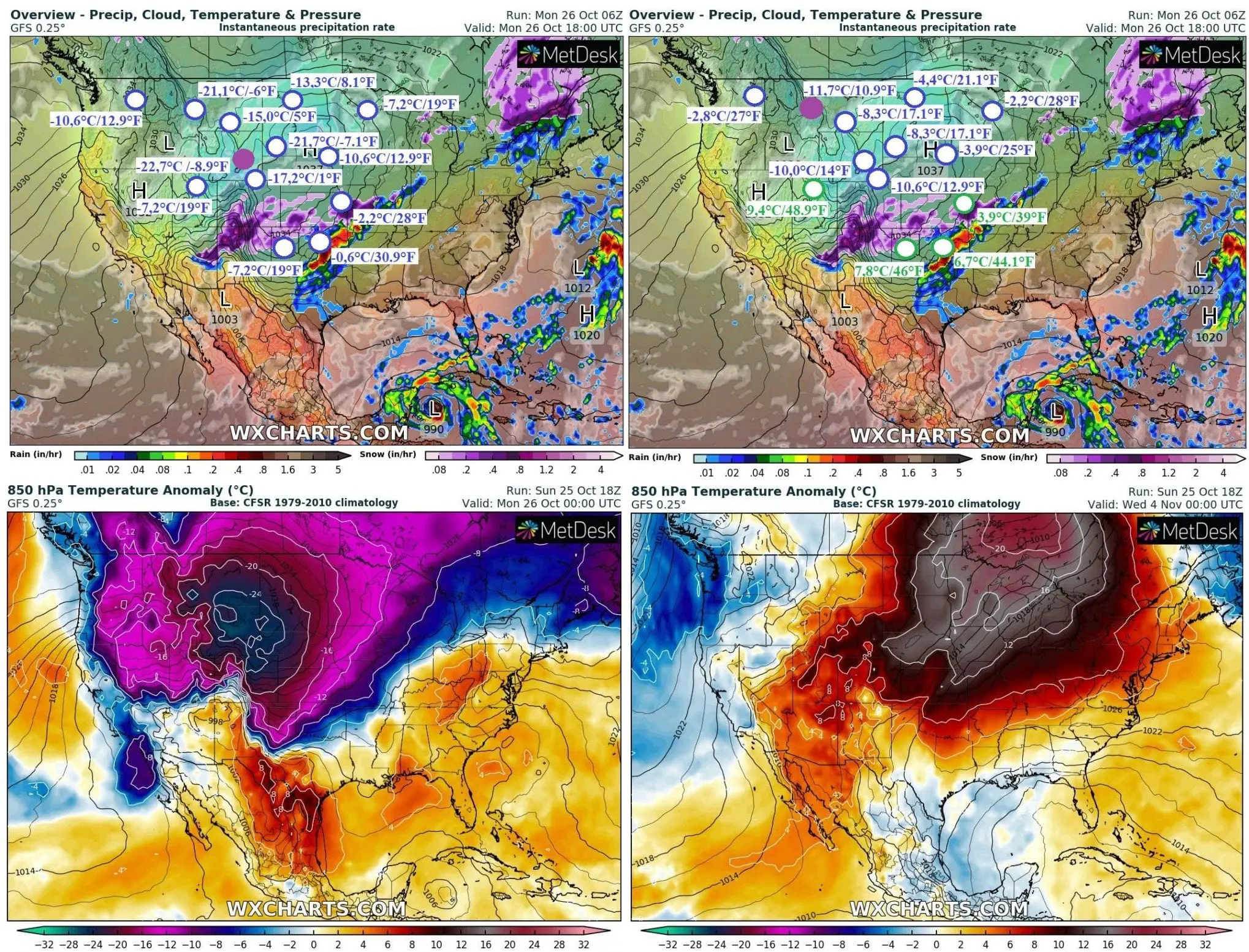
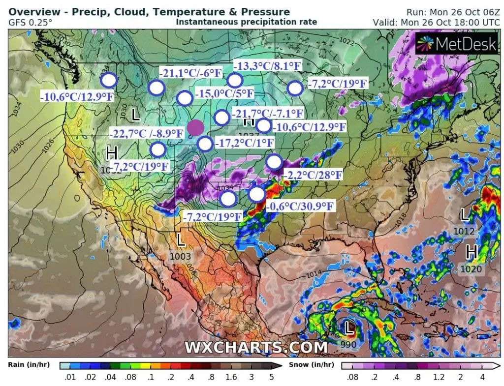
Interesting were other lower elevated parts of the USA and southern Canada on Monday (or Sunday) 25.-26. October 2020: in Blood Tribe in Alberta (980 MASL) has been measured -25,7°C / -14.3°F on Sunday, in Puntzi Mountain in British Columbia (910 MASL) -25,3°C / -13.5°F on Monday, in Rapid City, South Dakota capital -21,7°C / -7.1°F on Monday, in Helena, Montana capital -21,1°C / -6°F on Monday, in Cheyenne, Wyoming capital -17,2°C / 1°F on Monday, in Great Falls, Montana -17,2°C / 1°F on Monday, in Billings, Montana -15,0°C / 5°F on Monday, in Bismarck, North Dakota -13,3°C / 8.1°F on Monday, in Sioux Falls, South Dakota -10,6°C / 12.9°F on Monday, in Spokane, Washington -10,6°C/ 12.9°F on Monday, in Norfolk, Nebraska -8,9°C / 16°F on Monday, in Amarillo, Texas -7,2°C / 19°F on Monday, in Duluth, Minnesota -7,2°C / 19°F on Monday, in Salt Lake City, Utah, -7,2°C / 19°F on Monday, in Minneapolis, -4,4°C / 24.1°F on Sunday and Monday, in Kansas City, Kansas, -2,2°C / 28°F on Monday and in Oklahoma City -0,6°C / 30.9°F on Monday.
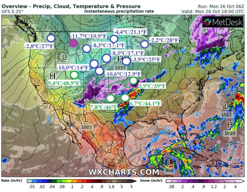
The coldest regions has experienced with Arctic days – maximum temperature has reached only to -11,7°C / 10.9°F in Helena, -10,6°C / 12.9°F in Cheyenne and -10,0°C / 14°F in Casper on Monday. In Great Falls, maximum temperature has reached -8,9°C / 16°F (Sunday), in Rapid City -8,3°C / 17.1°F, in Billings -8,3°C / 17.1°F, in Bismarck -4,4°C / 21.1°F, in Sioux Falls -3,9°C / 25°F, in Denver, Spokane and Norfolk -2,8°C / 27°F, in Duluth -2,2°C / 28°F, in Minneapolis -1,7°C / 28.9°F (Sunday), in International Falls -1,1°C / 30°F, in Kansas City +3,9°C / 39°F, in Amarillo +7,8°C / 44.1°F and in Salt Lake City +9,4°C / 48.9°F on Monday.
In Southwest, severe winds are linked with spreading of wildfires, in Flagstaff, Arizona has been measured wind gusts 106 km/h / 66 mph on Monday and situation should be worse during next hours.
Electroverse.net, Accuweather and Weather Nation has informed, that October snowfall records have fallen in wide-area from Northwestern USA, Great Lakes to Texas (more records mentioned in previous article – link above), e.g. Mishowaka, Colorado, 17 inches / 43.2 cm / 24 hours, Spokane, Washington 8 inches / 20.3 cm / 24 hours on Sunday / Saturday, but too 2-day weekend records: Missoula, Montana 13.8 inches / 35 cm, Rapid City 7.8 inches / 19.8 cm. In Great Falls, Montana, has fallen in October 2020 together 27.7 inches / 70.4 cm of snow and all-time October snowfall records has been reported from Great Lakes Areas, Rockies, Northern Plains and Midwest during last period, too.
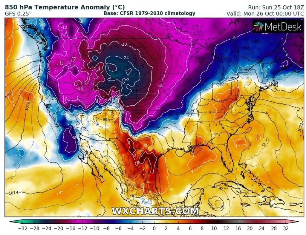
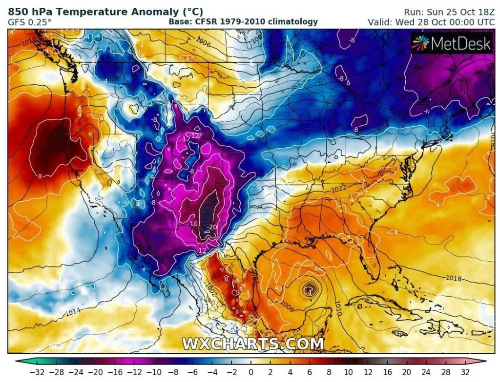
The worst nights have many regions ahead of only now – night from Monday to Tuesday will be extreme cold in central and southern parts of Central USA and night from Tuesday to Wednesday in Southern USA. Skies make clear and mainly in places with the snow cover it will be record cold – according to GFS, regional 850 hPa temperature anomalies will be lower than -24°C, in 2 meters will be regionally 30°C colder as usual.
If you live in region or plan vacation in Rocky Mountains, Midwest or South, consider all available meteorological sources including weather news, forecasts and warnings for better preparedness before minimally the strongest October coldwave minimally since year 1800.
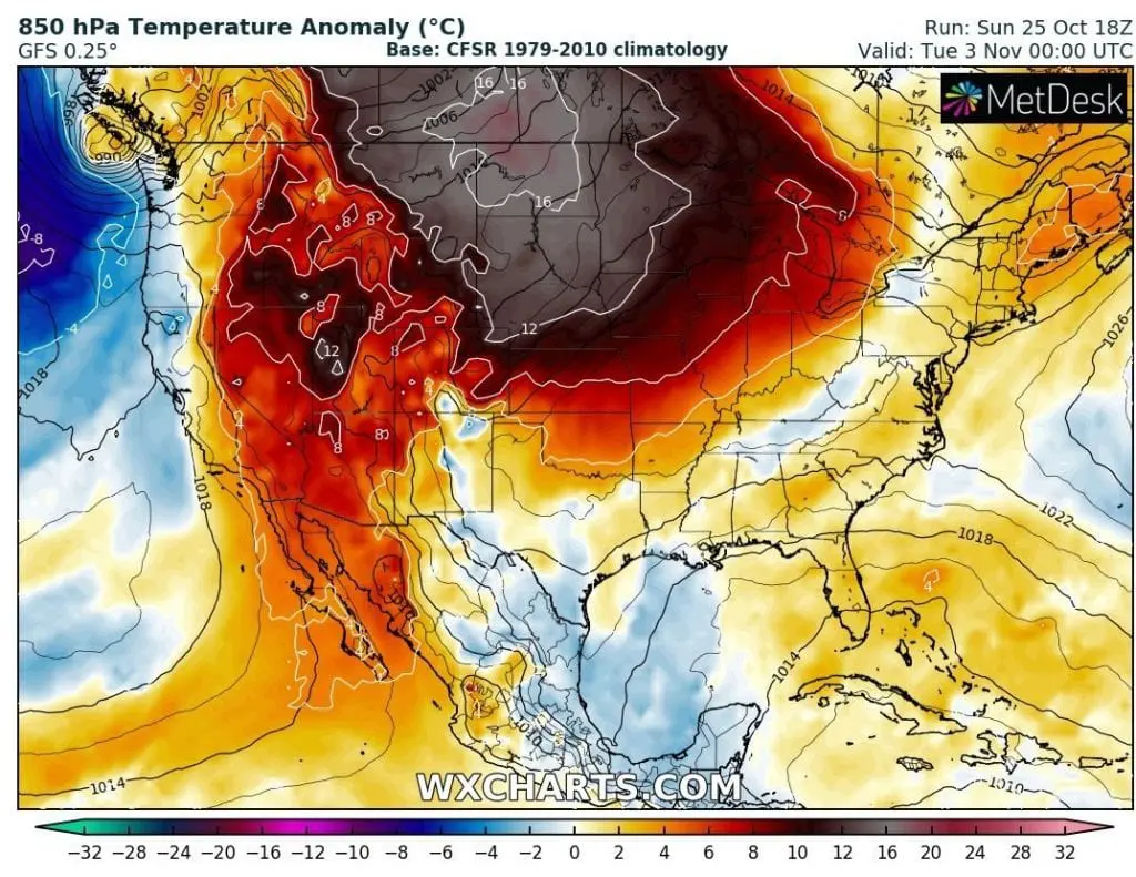
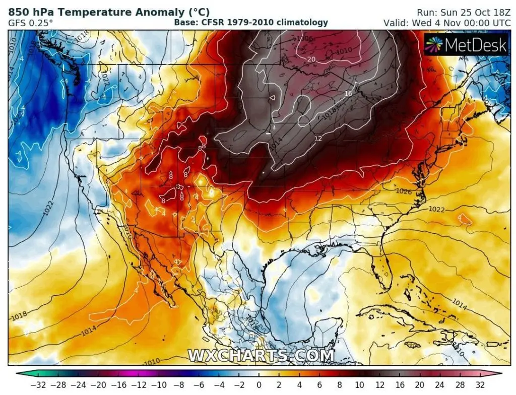
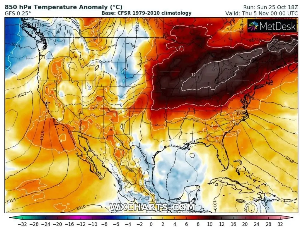
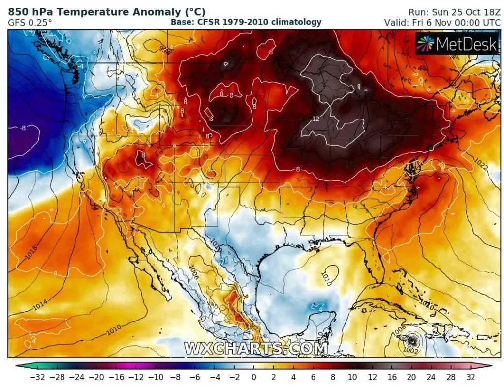
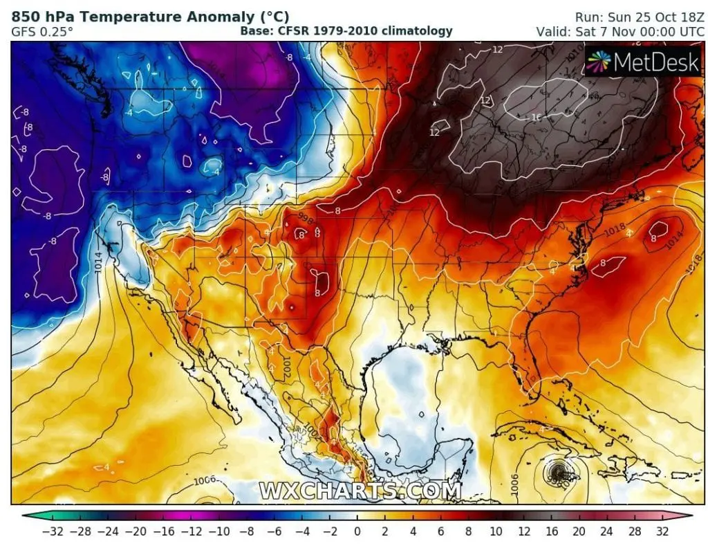
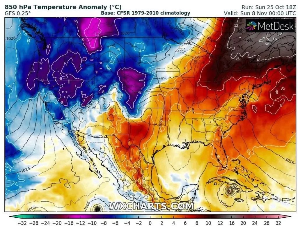
Good news are, that in early November, totally opposite weather pattern is expected, mainly in northern USA and southern Canada, with temperature anomalies above +20°C from long-term averages and very late Indian summer conditions.
Infographics: wxhcarts.com:
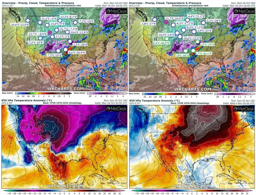
A: Measured Minimum and Maximum temperatures in chosen cities in the USA on Monday (or Sunday) 26. (25.) October 2020:
T850 hPa anomalies – Monday, Tuesday and Wednesday´s mornings, 26.-28. October 2020:
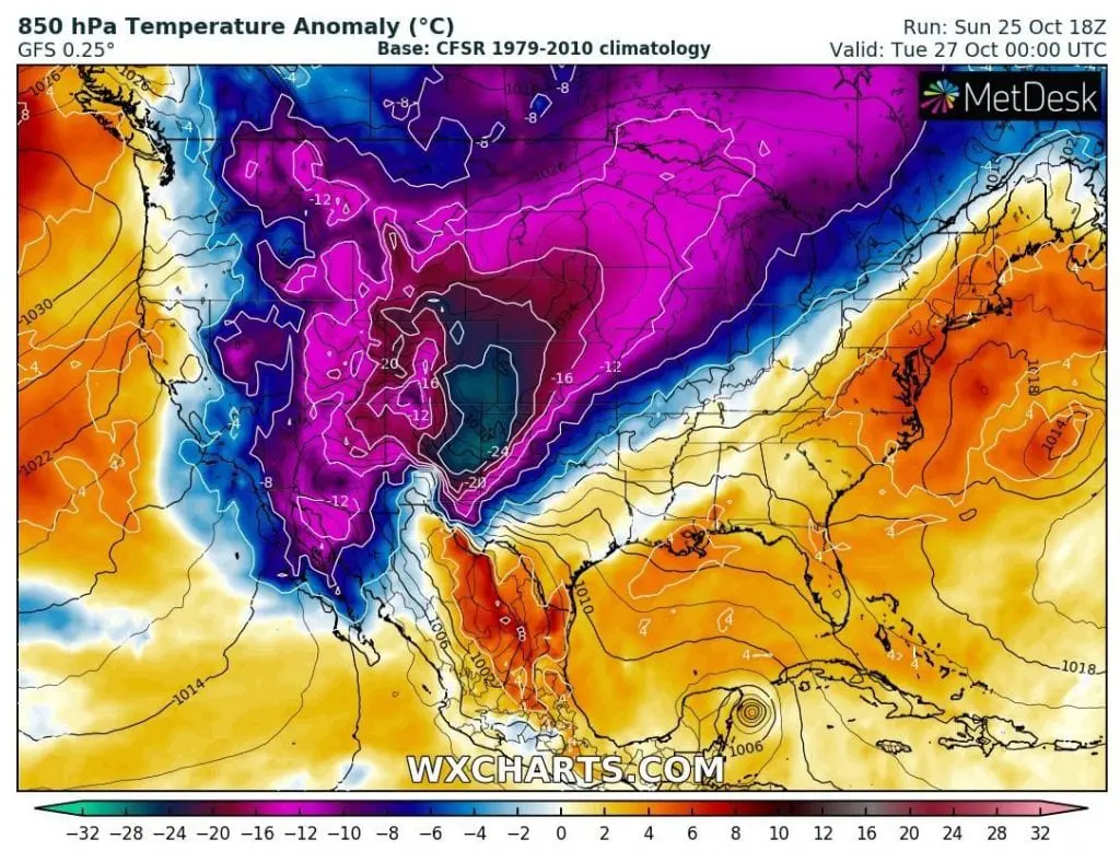
T850 hPa during the expected Indian summer (3.-8. November 2020):