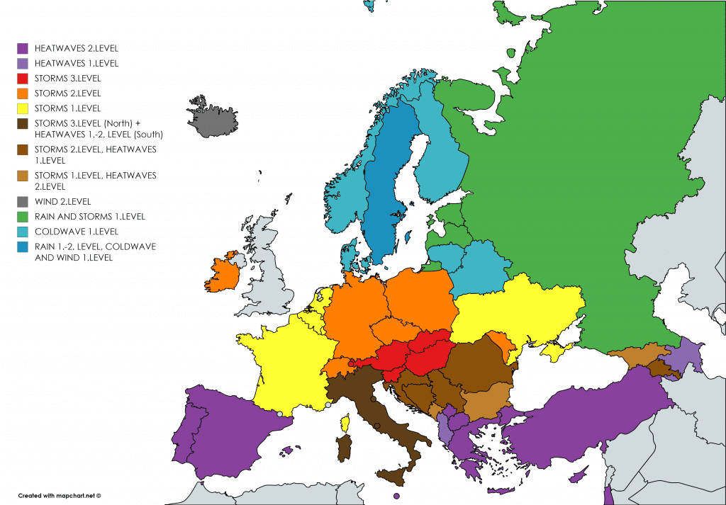
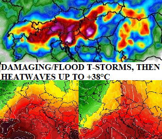
Damaging T-storms in Friday and Saturday in AU, HU, SK, SI, HR will be EXTREMELY strong, in Sunday will start big heatwaves over Central Europe (northern parts including)

Temperatures from -0,8°C (Norway) to +43,2°C (Spain) in Europe, surprised Mostar (Bosnia and Herzegovina) with +38,3°C and Billund (Denmark) with +3,4°C
In Monday and Tuesday, peak of current heatwaves in Europe was observed, with +43,2°C in Sevilla in Monday and +43,0°C in Andújar in Tuesday in Spain /aemet.es/ and +36,6°C in Knin, Croatia in Tuesday. In other parts of Europe, the most hottest day is Wednesday, with +38,3°C in Mostar, Bosnia and Herzegovina, +36,7°C in Le Luc, France, +36,1°C in Podgorica, Montenegro, +35,3°C in Amendola, Italy, +35,3°C in Tirana, Albania, +34,8°C in Konitsa, Greece, +33,°C in Sliven, Bulgaria, +33,3°C in Negotin, Serbia, +32,8°C in Strumica, North Macedonia, +32,7°C in Calarasi, Romania. In the northern parts of Central Europe was hotter in Tuesday /https://mkweather.com/2020/07/21/alpine-and-carpathian-region-at-large-scale-flood-risk-in-friday-and-saturday-over-100-mm-24-hours-of-precipitation-can-fall-regionally// and in Wednesday, colder air was shifted above area.
Very cold air arrived above northern parts of central Europe and Scandinavia, already, with only +3,4°C / 38°F in Denmark lowlands (Billund), +4,8°C in Netherlands (Hupsel), +5,4°C in Belgium (Retie) and only +6,1°C in Koeln in Germany. In Sweden was measured +2,7°C (Gustavsfors), and in Norway only -0,8°C (Folldal Fredheim) and -0,1°C (Drevsjo).
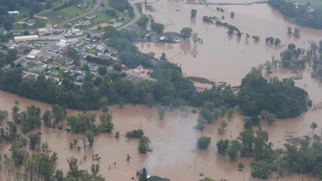
Friday-Saturday damaging T-storm event in southern- Central Europe will be worse, than before a day was expected, SU, IT, AU, SK, HU, SI, HR, UA, RS and RO had to be prepared to severe storms with flash floods
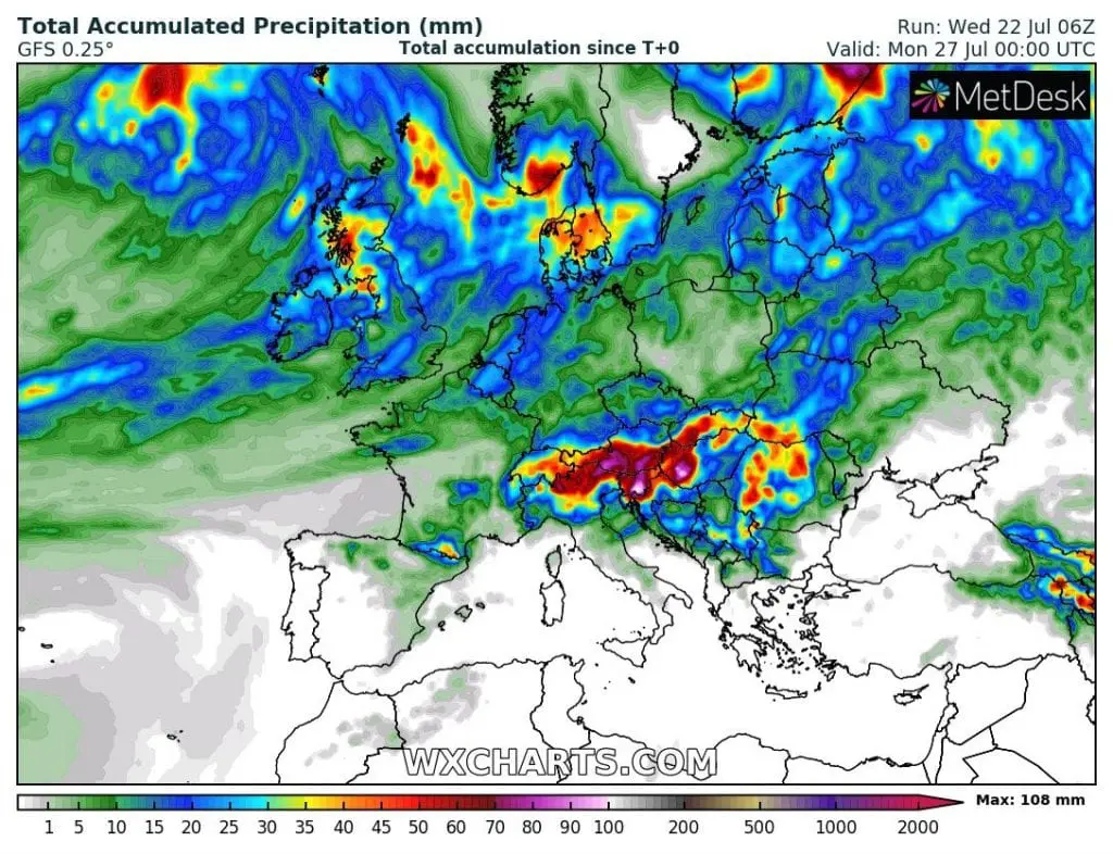
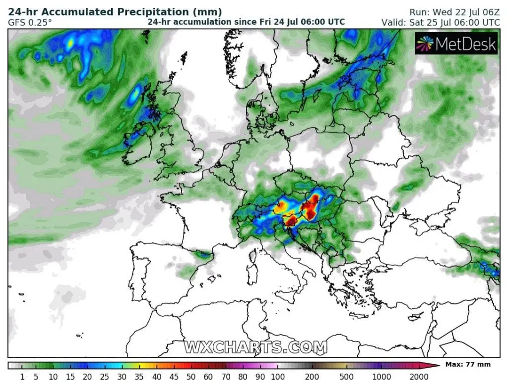
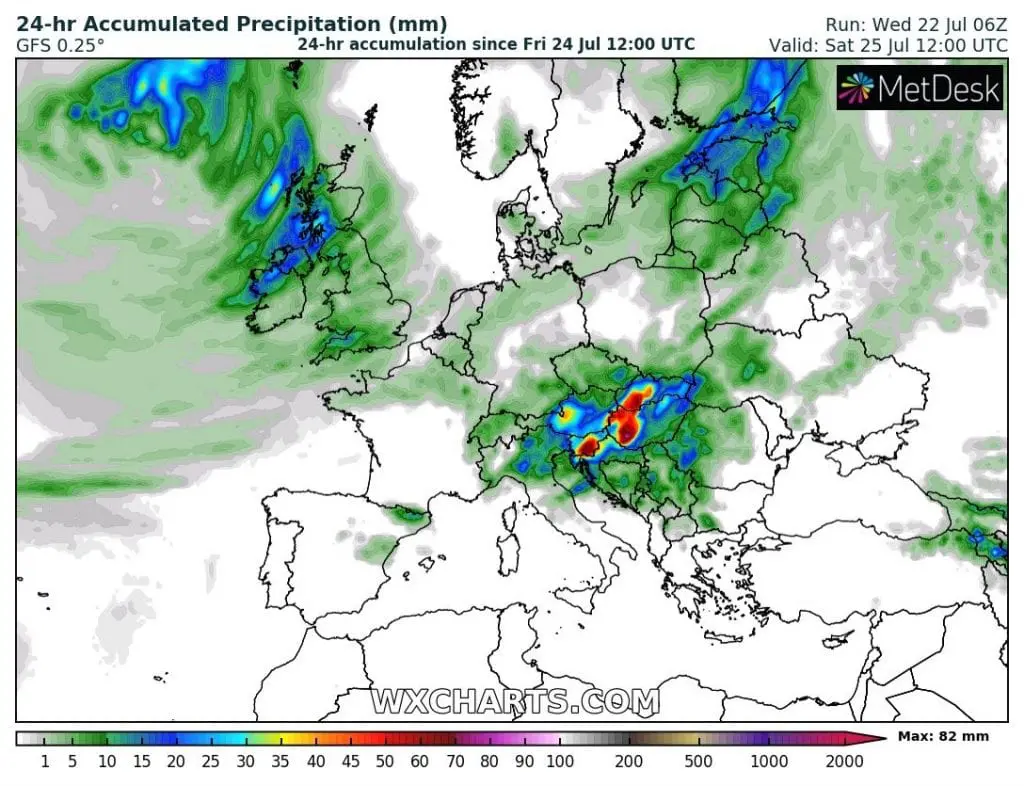
The worst situation is forecasted for Austria, Slovakia, Hungary, Slovenia, northern Italy and Croatia, Carpathian Ukraine and Romania during Friday-Saturday, with precipitation amounts over large area above 50 mm, with regional amounts over 100 mm and flash floods in mentioned areas. Locally, severe storms can occure in Switzerland during Serbia during night Friday-Saturday, some surprises can be register in southern Poland/Czech republic too.
Wednesday´s outputs of meteorological models are even more severe than in Tuesday, with red areas over 50 mm/24 hours in large parts of Austria, Hungary and Slovakia. The worst will be Friday evening and night, but in eastern regions Saturday´s morning too. People in region had to be prepared for damaging storms with heavy rain, lighting, severe winds, hail or possible flooding effects. Storms such these can threat lives, property and ecosystems.

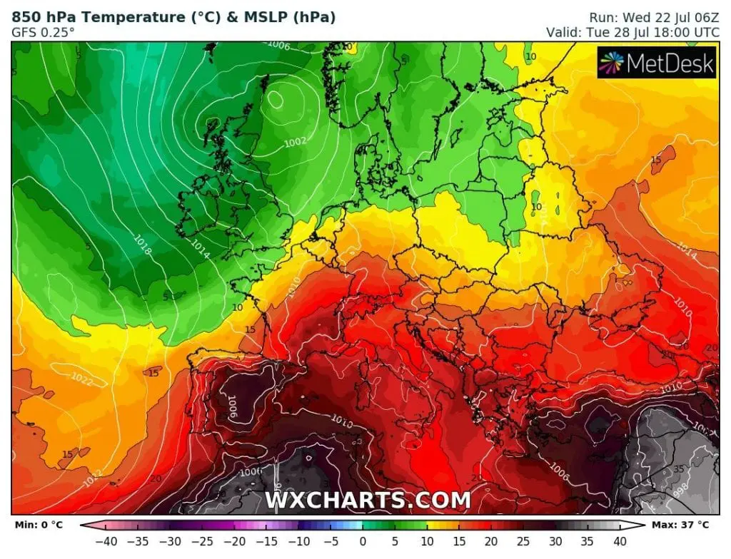
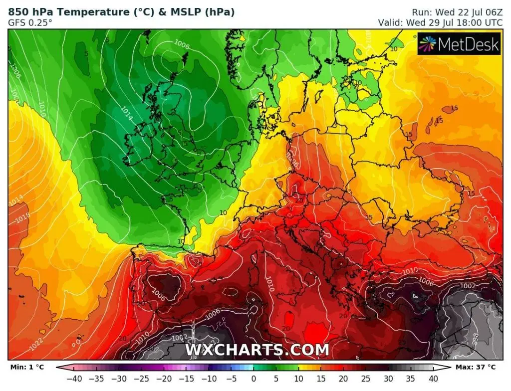
After damaging T-storms big heatwave in Central Europe (including northern parts of Germany, Czechia, Poland) from the start of the next week are expected
T850hPa over +20°C above Czechia, Austria, Bavaria, or Slovakia and over +15°C above the whole territory of Poland – such are the outputs of GFS from Wednesday for Central Europe to first half of the next week. It means maximum temperatures up to +38°C in Czechia and countries around! Heatwave had to start already in Sunday in Alpine region and hot air will expand to the north during the next days. For now, +38°C in Czechia, +38°C in Austria, +37°C in Slovakia, +37°C in Hungary, +37°C in Switzerland, +36°C in Poland, +36°C in Bavaria and up to +40°C in Balkan, +38°C in Italy and +44°C in Spain is possible, with possibility of tropical nights (over +20°C / 68°F) in lowlands.
Heatwave partly hit southern Sweden too, with possible temperatures above +30°C and later, Easter Europe. Heavy storms then could hit UK, Germany, Benelux, Denmark and Alpine region on the incoming cold front. The good news is, that hot weather would return in central parts of Europe during first decade in August.
:max_bytes(150000):strip_icc()/GettyImages_BA18301-56a1329b3df78cf7726852b5.jpg)