First forecast for Winter 2020/21: early powerful coldwaves (NOV/DEC), then weakening of cold pattern and warm (JAN/FEB/MAR)

It´s one month before the end of summer 2020 and very curious climatologists has started with serious discussions about character of upcoming Winter 2020/21.
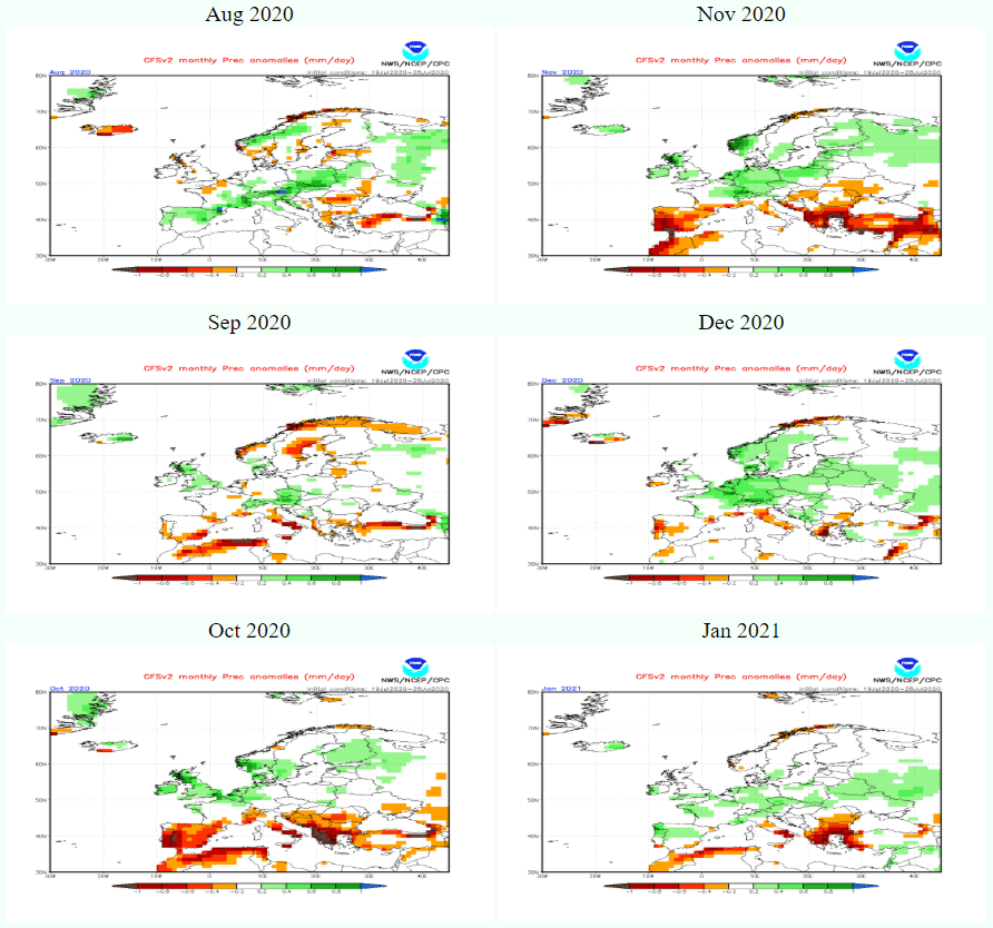
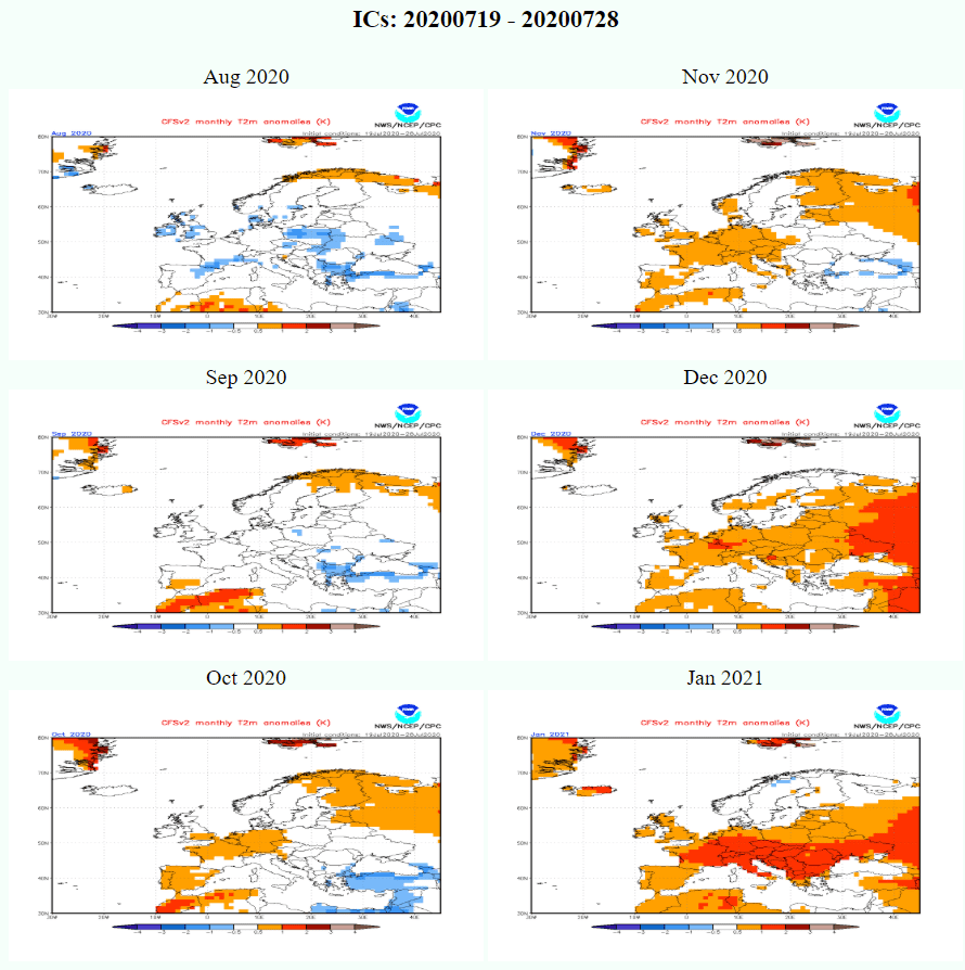
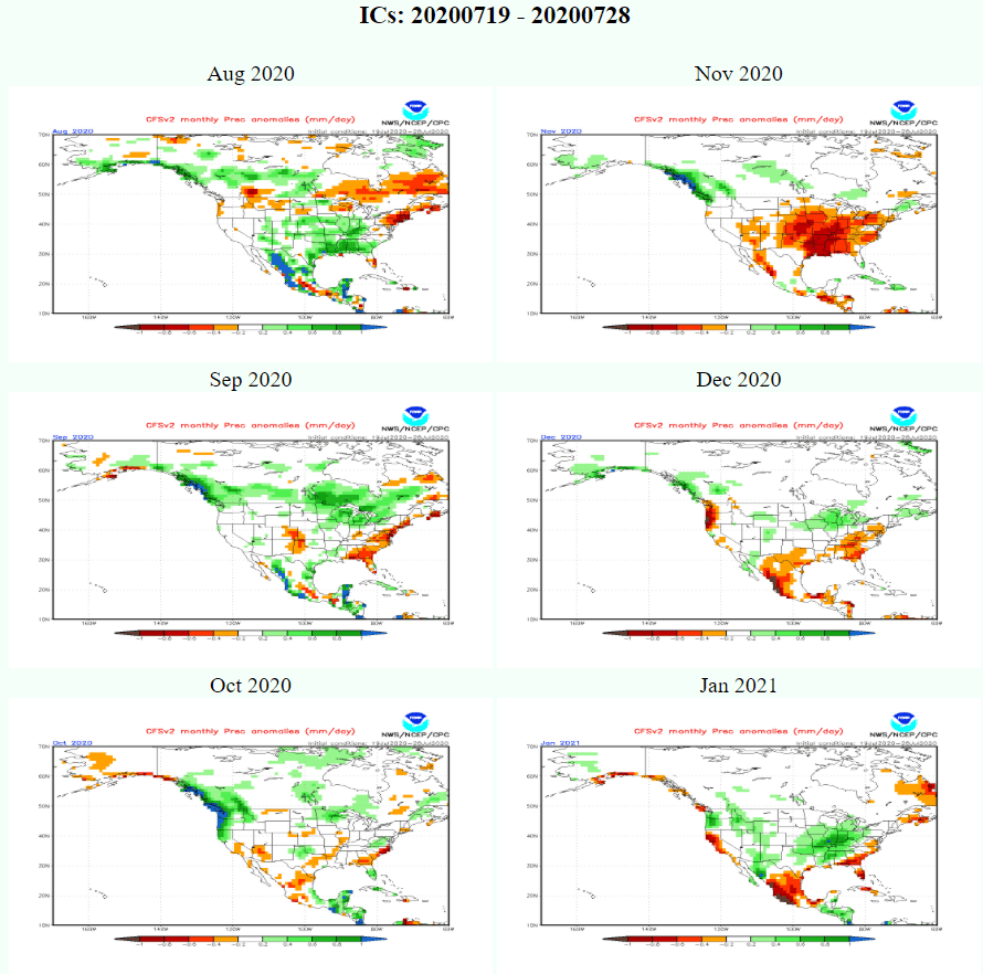
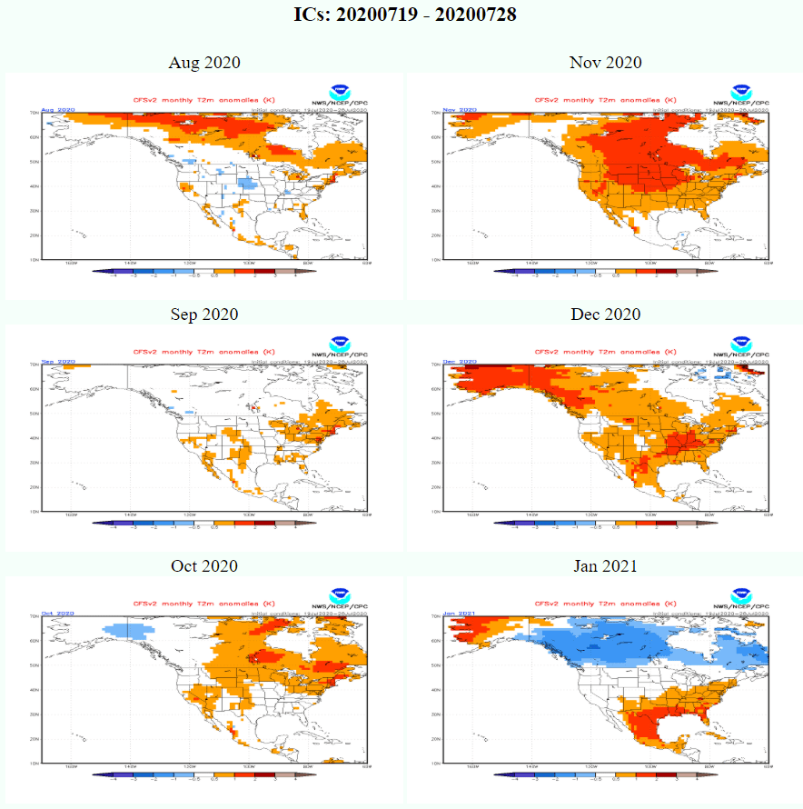
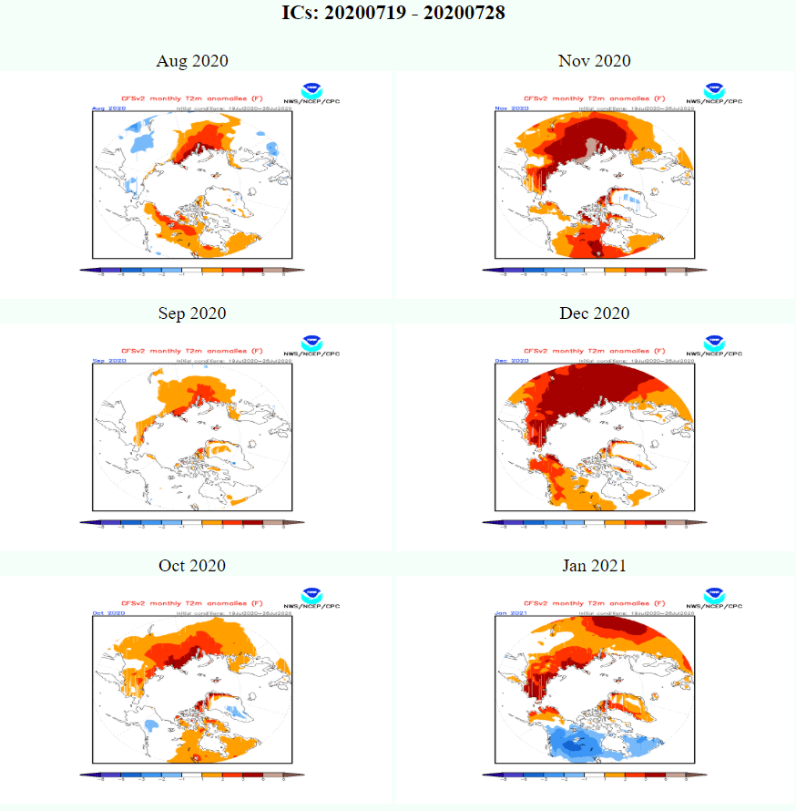
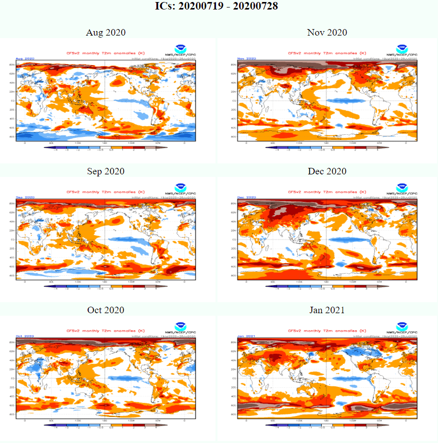
At all, very good start of winter 2020/21 is expected, with powerful cold blasts in November and December 2020 (La niňa, NAO-, PNA-, QBO not so much westerly, solar minimum, Arctic change, GW hole, AMOC, Siberian snow cover). Then is situation questionable and here is a risk, that cold potential will be weakening – January and mainly February and March 2021 could be warm (QBO+ strong westerlies possible, AO+, NAO+, lower effect of Arctic, Atlantic and Siberia too). Situation in North America will be reversely as in Europe – according to CFS too – with warmer weather during late autumn and stronger cold spells in JAN-FEB-MAR 2021. However, described pattern is regionally opposite and can cause reverse weather behavior in Canada, Great Lakes area and part of Northeast, with warmer NOV-DEC 2020 and colder JAN-FEB-MAR 2021.
Let’s look at important parameters that can significantly affect the nature of the coming winter 2020/21:
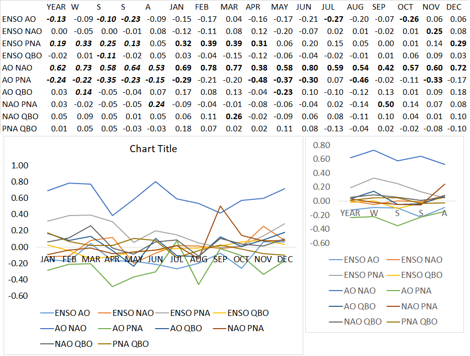
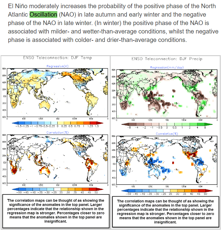
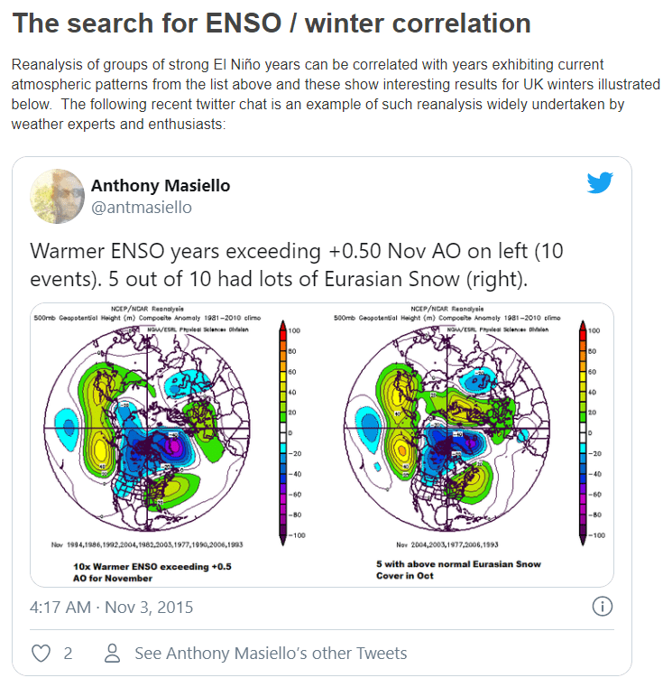
ENSO and AO/NAO: La-nina phase is ongoing and for next seasons expected; it´s linked with AO+ during the year, but in November and December, strong link with NAO- was found. ENSO is too linked with PNA+ during the year, most weakest correlation between ENSO and PNA is in the autumn.
AO- and NAO- are in Northern hemisphere winters linked with increases risk of cold spells, while AO+ and NAO+ are linked with warm winter conditions. Important is mainly weak/strong pressure gradient between Icelandic low / Azores high and Aleutian low / Hawaii high. PNA pattern howewer, is positively linked with ENSO (El-niňo = PNA +, La-niňa = PNA-), therefore winter in west and central US and Canada could be cold-successful in JAN-FEB-MAR too.
QBO: QBO has alived during the past months a huge unexpected jump – its easterly phase was quickly jumped to westerlies. While QBO is defined as regular 28-month oscillation, it´s easterly (negative) phase was skipped for extremely short time – only 7,5 months! (had to be 14 months – with climate something bad is happening). It means, that in the winter 2020/21 we will be more quickly (during late winter) close to strong westerly phase, what could destroy our imaginations about extreme winter coldwaves.
Eastward phases of the QBO often coincide with more sudden stratospheric warmings, a weaker Atlantic jet stream and cold winters in Northern Europe and eastern USA whereas westward phases of the QBO often coincide with mild winters in eastern USA and a strong Atlantic jet stream with mild, wet stormy winters in northern Europe.
Arctic melting: In last years, extreme Arctic melting is linked with more Siberian snow cover in autumn, Global warming hole anomaly in North Atlantic, AO- patterns in autumn and at the beginning of winter. Currently we are aliving the next minimum of Arctic sea ice extent, therefore, conditions for early cold blasts are very good. Change in Arctic is linked with more frequency of sudden stratospheric warming and the following coldwaves in Northern Hemisphere.
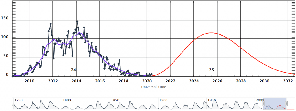
Currently Solar cycle minimum: Sun spots are on total minimum during these months, it is very favorable for better winter conditions. 2/3 years with strong westerlies and strong easterlies (QBO) during solar minimum were linked with sudden stratospheric warmings (and extremely cold spells) during the winter.
Global warming hole and AMOC: Arctic melting is shifting Gulf stream to the southerly positions over Northern Atlantic and SW from Iceland, negative anomalies in air and ocean water temperatures are occuring more and more frequently. It´s linked with cooling efect of W/NW/ N coasts of Europe (Portugal, Biskay bay, British Isles, Norway).
Siberian snow cover in autumn linked with AO-: It was observed 85% correlation between AO- and Siberian snow cover during October. Warm Arctic produce more humidity, what is causing more snow cover over continents of Northern Hemisphere. Next favorable parameter for earlier cold blasts in OCT-NOV-DEC 2020.
MJO: It would be favorable, if MJO 6-8 phase will be present during late autumn 2020 and early winter 2020/21. It´s mostly linked with AO-/NAO- from all 8 phases (low pressure above tropical Pacific, South America and western-african Atlantic).

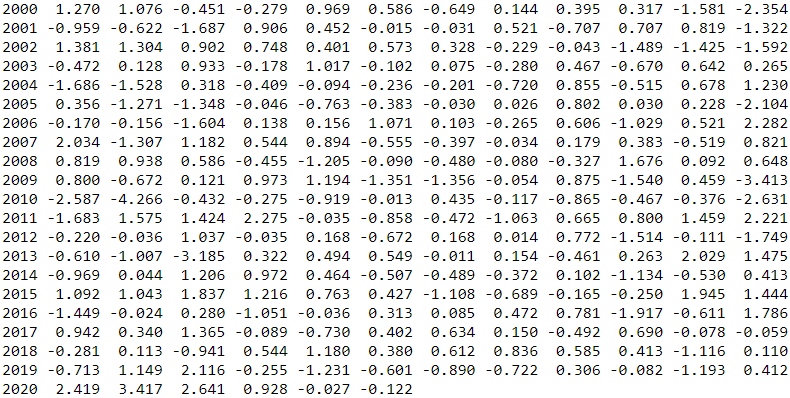
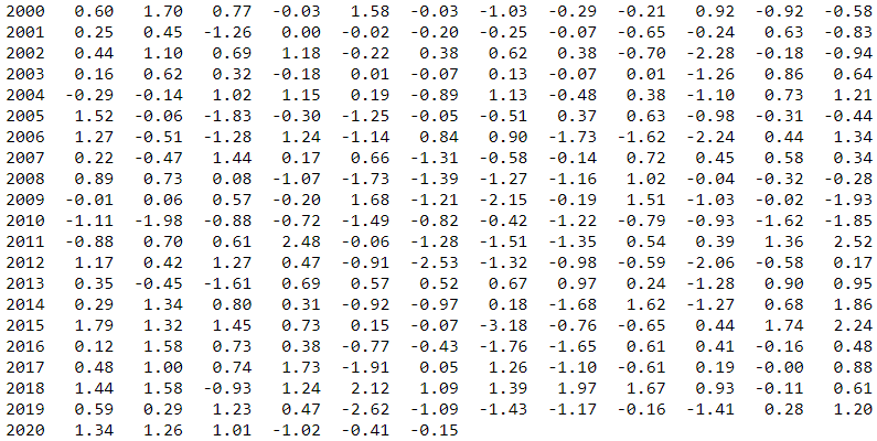
https://www.cpc.ncep.noaa.gov/products/precip/CWlink/pna/norm.nao.monthly.b5001.current.ascii.table
Illustrating photo: https://ourbackyardfarm.com/frost-tolerant-plants/; https://pxhere.com/en/photo/627469