SUMMER 2025 FORECAST FOR NORTH AMERICA AND THE USA: AT THE FIRST HALF MORE FLOODS, AT THE SECOND HALF PEAK OF THE SUMMER – STRONG WILDFIRE SEASON ON THE WEST, DEADLY TORNADO AND HURRICANE SEASON ON THE EAST
Summer 2025 forecast for North America and the USA
Summer 2025 is almost here, and Mkweather (mkweather.com) is bringing the first continental updates of seasonal forecasts for Europe /https://mkweather.com/summer-2025-forecast-for-europe//, North America, and Asia for Summer 2025, Africa for Winter and Summer 2025, Australia for Winter 2025, South America for Winter 2025, and Antarctica for Winter 2025. Our content you can find on Facebook /https://www.facebook.com/profile.php?id=61575785696424/, and gradually on former Twitter (X) and Instagram.
This article will look at the forecast Summer 2025 conditions in North America and the USA.
Overall, North America will be similar to Europe /https://mkweather.com/summer-2025-forecast-for-europe// divided into two main regions with opposite weather patterns, very probably, and with a character of an atmospheric blocking situation, too. Generally, there will be a relatively colder and stormier eastern part of North America, with a pressure trough from the Canadian Arctic trough Great Plains, and the Great Lakes into the Midwest, parts of the Northeast and Mid-Atlantic, temporarily up to the Gulf coast and there will be persisting hot and dry air masses above parts of western third, maybe partly half of the USA, British Columbia, Alberta, flowing from anomalously hot and dry Mexico. Mainly in the Midwest will be between these 2 regions furthermore good conditions for strong tornado season, although, after Spring 2025 peak, but with possible severe strikes of robust frontal systems producing hard T-storms, and possible derechos, supercells and multicell systems (,…) at the border of colder and wetter (temporarily regionally very cold or stormy) air on the East and dry and anomalously hot (temporarily regionally extremely hot and dry) air on the West.
It’s important to note that the first half of Summer 2025 (similar to Europe) should be with more precipitation, rains, storms, floods, or landslides, while the second half of Summer 2025 will be mostly hotter and drier across the continent with a long-expected peak of Summer 2025.
Hurricane season and Tornado season 2025 in the region will be, according to our forecasts and many other sources, significantly above average, with another deadly year, possibly one of the worst, with some chance of the worst year ever. Both hurricanes and tornadoes will be participating in an above-average precipitation pattern above the eastern half of the USA and partially parts of Canada, and the Caribbean. Important factors for both tornadoes and hurricanes will be a strengthening La Nina pattern, and expected AO- / NAO- (negative phase of the Arctic and the North-Atlantic Oscillation), too. Stratosphere and QBO will be shifting from Westerlies to Easterlies slowly (but will be only a weak factor), and the next moisture will be escaping from the Arctic.
Negative phase of PDO in combination with La Nina will be linked with “Heat Domes” above western parts of the USA and SW Canada, often with basis in hot air masses above Mexico. This pattern will be evoking PNA+ phase, with hot West and stormy East, but PNA will be in the negative phase, with changes caused by global warming; however, its impact on western parts of the continent will be in summer time significantly reduced.
Extremes in weather in Summer 2025 should be in North America miscellaneous – from snow and rain storms in Greenland and Canadian Arctic producing mainly by extremely warm Arctic, producing Global warming hole anomaly in Northern Atlantic, too; through heavy rains and extreme storms in eastern half of the continent, especially above the Great Lakes region, the Great Plains, parts of Midwest, Northeast, Mid-Atlantic and partially Southeast or even Florida, with a possibility of persistent pressure low configurations with severe storms (derechos, MCSs, supercells with damaging and deadly tornadoes, possible floods or locally landslides), later with the start of the strong Hurricane 2025 season; then mainly above Midwest, where will be warmer, with possibly surprisingly strong tornadoes mainly in the first half of Summer 2025 (similarly like gusty winds, hailstorms, heavy rainfall or severe lighting); to extreme and deadly heatwaves and drought on the West, from California to British Columbia, with a possibility of regionally anomalously low levels of water of rivers and creeks and high mortality during the peaks of the season as well as excessive wildfires and drought. From other clusters of weather patterns is worth mentioning snowy/rainy Greenland, with relatively colder SE parts, very warm and rainy Canadian Arctic, the Caribbean mostly marked by severe Hurricane 2025 season, such as very cold and dry Baja California region due to La Nina / PDO-. Central America will be mostly hot and dry, but parts of the Caribbean coast should be very stormy, with a possibility of early Major hurricanes.
A few main factors will be affecting conditions during the upcoming Summer 2025:
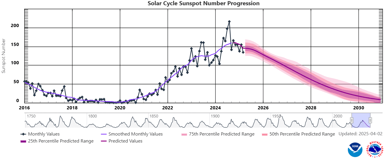
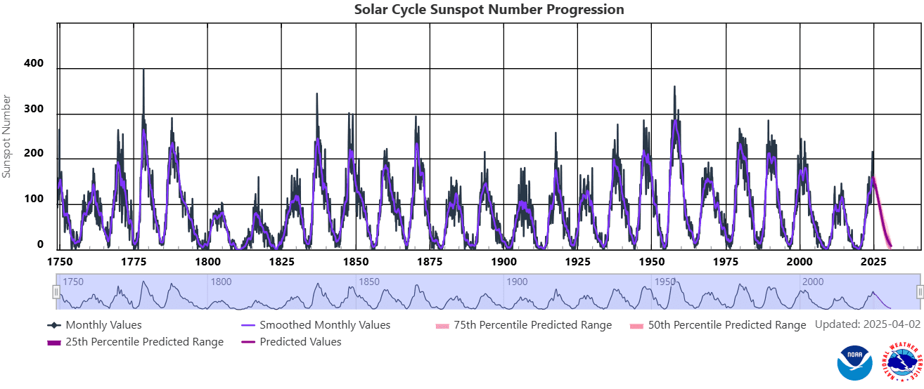
1. Sun cycle
Surprisingly strong solar activity during the peak of the current 25th solar cycle in the last years was associated with a strong phase of La Nina in its coming phase, it means from spring 2020 to spring 2023 (together 3 years of La-Nina driven climate anomalies around the Earth) and a short, but strong El-Nino in its peaking phase from Spring 2023 to Summer 2024. Now we are again in La Nina phase, but relatively weak La Nina, with a decrease of sunspots and geomagnetic storms, it means yearly lower chances for NAO+, mainly in the winter. In the Little Ice Age, a weak Sun activity produced Godzilla El-Ninos and strong AO- and NAO- patterns across the Northern Hemisphere with a result in hunger, bad harvests, diseases, fear, and finally, an inquisition. A peak of the strong solar activity was observed between 1950 – 2000, and from then, activity was decreasing, however, the last cycle was observed surprising increase of the Sun activity, with surprising events in the first half of 2024.
From 21. to 22. February 2024 there was a big chance, that the Sun produced the strognest Triple-eruption in 24-hours In the last 30 years, maybe since 1900, maybe since pre-Middle age times (Middle ages hadn´t strong Sun stroms). There have been 3 Triple-eruptions in the last 20 years:
2013: weaker intensity 5/13/2013 2:17 N11E89 X1.75/13/2013 16:01 N11E85 X2.85/14/2013 1:11 N08E77 X3.2.
2014: weaker intensity 6/10/2014 11:44 6/10/2014 11:42 S15E80 X2.26/10/2014 13:03 6/10/2014 12:52 S17E82 X1.56/11/2014 9:10 6/11/2014 9:06 S18E65 X1.0.
2017: main eruption stronger, but 24-hour criterion not met9/6/2017 9:17 9/6/2017 9:10 S08W32 X2.29/6/2017 12:10 9/6/2017 12:02 S09W34 X9.39/7/2017 14:55 9/7/2017 14:36 S11W49 X1.3.
Year 2003 brought 2 giant eruptions, but again only 2 in 24 hours and not 3, does not meet criteria (https://sos.noaa.gov/catalog/datasets/sun-historical-solar-flare-2003/).
Previously the solar cycle peaked between 1989-1992: “The next 14 days produced 11 “X class” flares” March 1989: The largest geomagnetic storm in the 20th century: (https://agupubs.onlinelibrary.wiley.com/…/2019SW002278).
But even the strongest storm in 100 years did not produce 3 X ray bursts in 24 hours: (https://agupubs.onlinelibrary.wiley.com/…/swe20919-fig).
Stronger solar cycles occurred 3 more times from the 1950s to the 1970s, but we don’t know if there was a triple burst. If not, it may be the strongest triple burst since before the Middle Ages, when solar activity was at a strong minimum. Database: https://xrt.cfa.harvard.edu/flare_catalog/all_full.html.
The strongest geomagnetic storm in 21. century? The strongest since 1960 and the second strongest in 100 years? According to estimates of the daily Ap index for 11.5.2024, Ap 274 was measured (note: current Spaceweather data contains a number 271), which should be the second strongest X-ray attack on our bodies in 24 hours in almost 100 years (since 1932) (in modern history)! Stronger was only 1960 with Ap 280. If we overcame single days in the years 1989 and 2003, it will be the strongest geomagnetic storm since 1960 (in 64 years), which is a once-in-a-lifetime event. Moreover, weakening of solar cycles in 21. century is mostly expected, which should mean that this should be the strongest geomagnetic storm in 21. century! https://www.spaceweatherlive.com/…/top-50-geomagnetic…https://www.spaceweather.gov/…/aurora-dashboard….
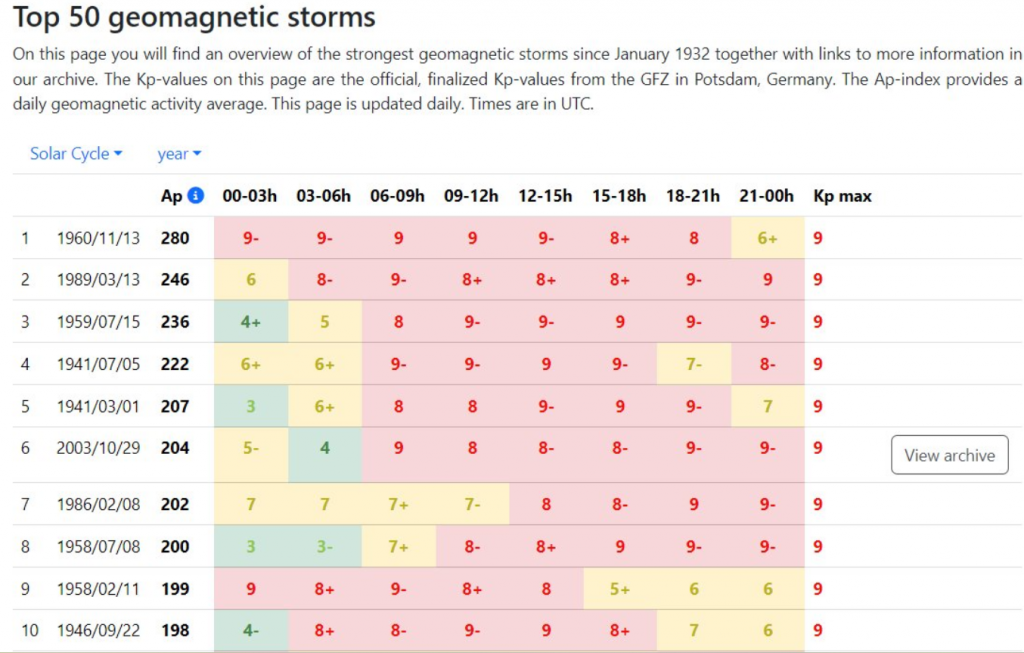
The strongest 24-hour geomagnetic storms until 11. May 2024 (placed in second place) /Source: spaceweather.com
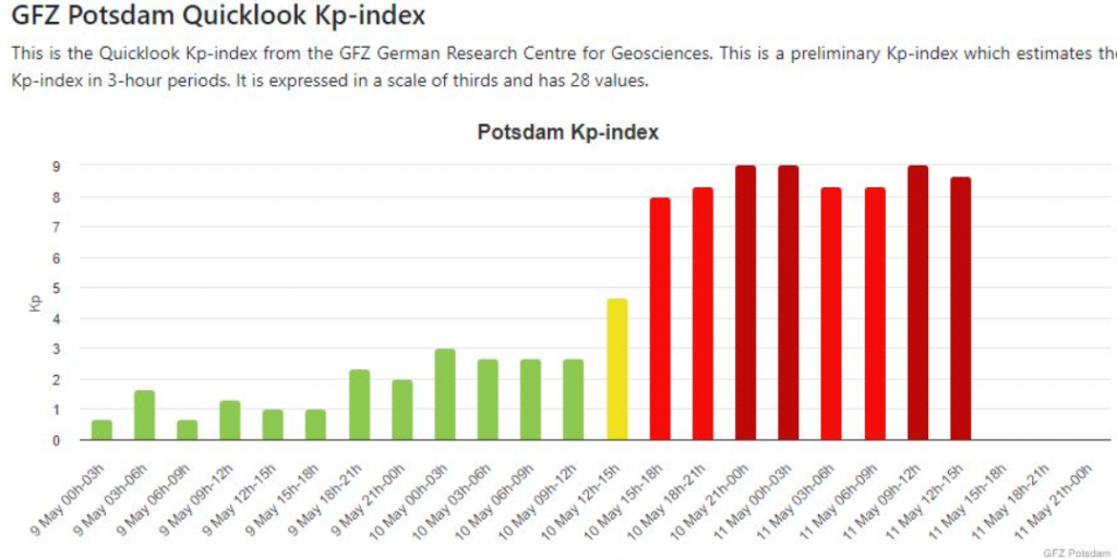
Source: https://kp.gfz.de/en/hp30-hp60
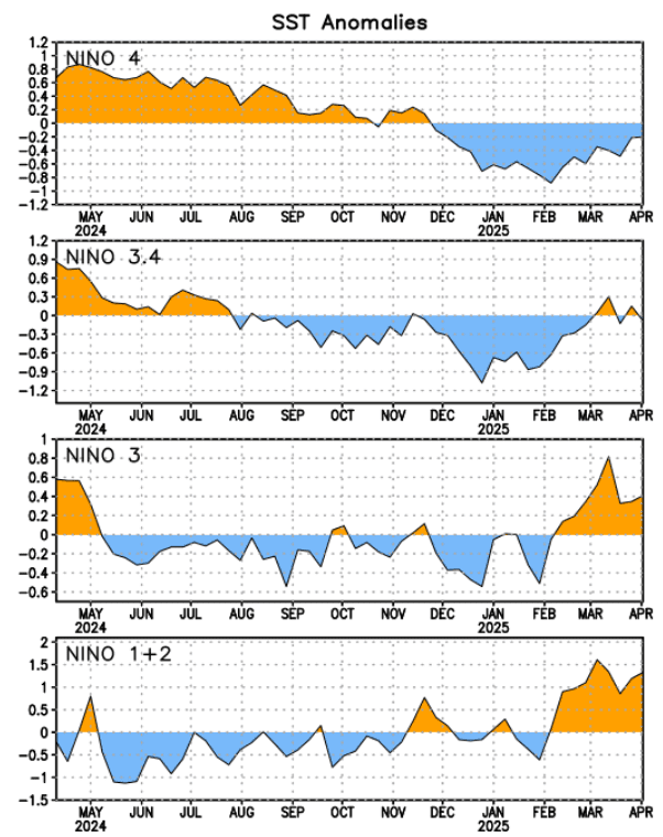
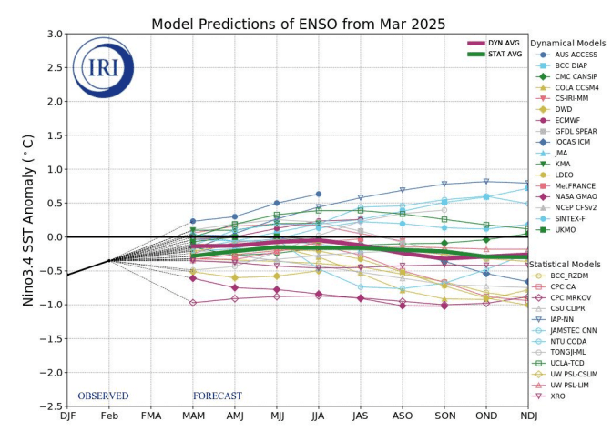
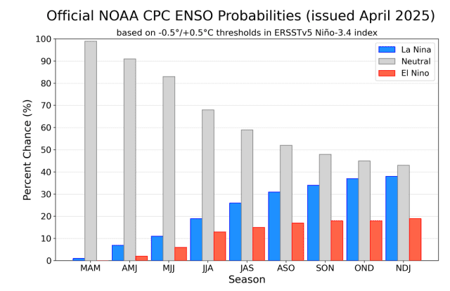
2. Probable strengthening La Nina
During Summer 2025 a shift from neutral phase to weaker La Nina pattern is possible.
Upcoming La Nina should have impact on growing season – mainly more precipitation in eastern half of North America thanks to expected strong Hurricane and Tornado season 2025. It should be linked with drought and hot conditions in western parts of the continent.
Weaker La Nina in the second half of Summer 2025 and in Autumn 2025 should mean a stronger Atlantic Hurricane season 2025 than if we have an El Nino phase or more neutral conditions. The first hurricanes in August 2025 should reach levels of major hurricanes (Cat 3+), with a possibility of a dramatic change of weather patterns, after hot peaking of Summer 2025.
Overall, La Nina is linked more with NAO+, however, it will be weaker – it means that typical NAO- character of summers in the last 20 years (only 6 summers since 2006 ended like NAO+) still should be preserved.
3. Mostly AO- / NAO-
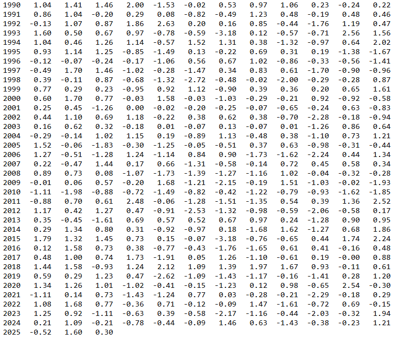
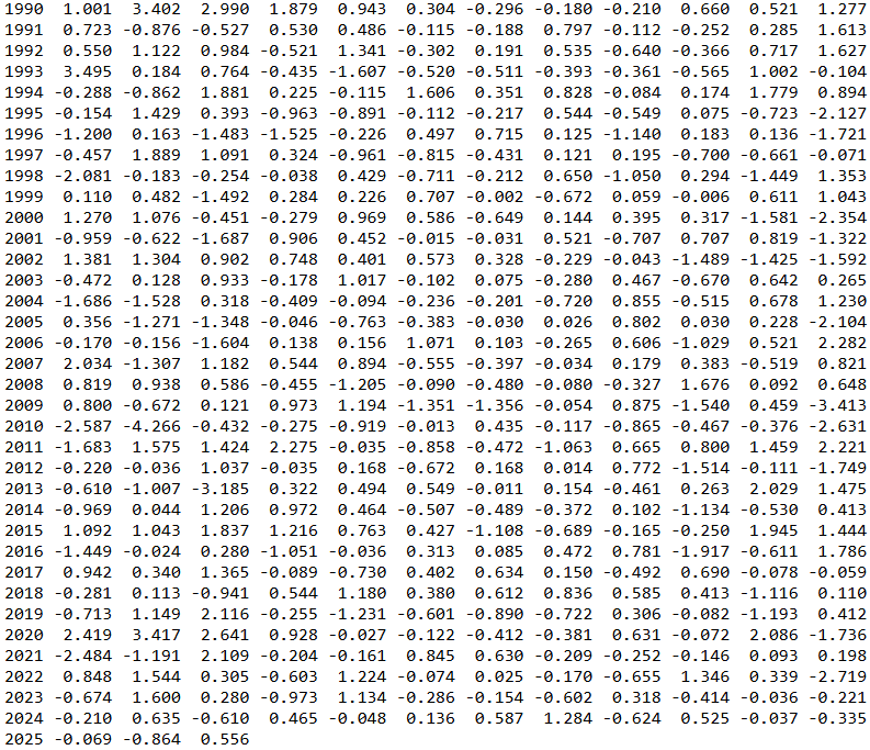
Since 2006 (in the last 20 years), overall, only 6 summers finished like NAO+ and only 4 winters like NAO-. It means, that chances for NAO- summers are more than 200% higher and chances for NAO+ winter around 500% higher than NAO+ for summer and NAO- for winter. In Summer 2025, there is expected mostly more or less weaker or stronger NAO-, again, or neutral phase; NAO+ is not probable overall, so far.
During NAO- phase in North America, stormy and colder eastern half of the continent is possible. In Summer 2025, this pattern should be partly well-preserved, with a possibility of atmospheric blocking not only above Europe /https://mkweather.com/summer-2025-forecast-for-europe//, but also about North America, too – with “Heat Domes” above the West and regenerating pressure trough on the East.
AO- phase should bring more severe heatwaves on meanders of jet-stream far northward – into the Canadian Arctic, Alaska, or Greenland, temporarily, mainly in late Summer 2025 (August?), like more storms on pressure trough up to the Gulf Coast in early Summer 2025.
In Summer 2025, probably mostly the NAO-phase (negative phase of the North Atlantic Oscillation) will be observed. It should be linked with the mentioned meridional pattern between rainy, stormy, and relatively colder eastern parts of the continent and hot and dry western parts of North America.
Intensity of NAO- is questionable, so far, from a slightly neutral or weak NAO- phase (the most probable) to a strong NAO- phase with anomalous atmospheric blocking, with pressure trough above eastern half of the USA and Canada and blocking anticyclone above western USA, British Columbia, Alberta and continental Mexico.
The last ECMWF output of NAO for Summer 2025 is mostly neutral, but the previous ones, from the previous months were mostly negative.
After the year 2000, approximately 2/3 of winters were NAO+, while 2/3 summers NAO-. NAO-, with similar (correlated) weather patterns in North America. An alternation of slower Rossby waves with a high amplitude means a lot of heatwaves replacing by severe storms, mostly.
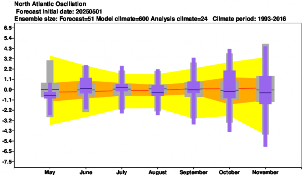
NAO forecast until October 2025 /Source: https://charts.ecmwf.int/products/seasonal_system5_climagrams_teleconnection?base_time=202504010000&index_type=NAE
4. A shift of Hadley Cell northward
Despite NAO- pattern, the shift of the Hadley Cell northward should push summer patterns to more northern regions, as usual – the Hawaii high will be stronger than in 20. century and hot periods alternating with stormy days will be relatively long, with mostly very warm anomalies in western North America. The shifted stormtrack should hit the northernmost regions in this changed climate. Rossby waves, however, should produce long pressure troughs with low-latitude situated lows and extreme high-latitude heatwaves on their front sides during a collapsing jet-stream.
Azores high will be relatively stronger, too, while the Aleutian and Icelandic lows, especially in summer, will be weak and shifted northward.
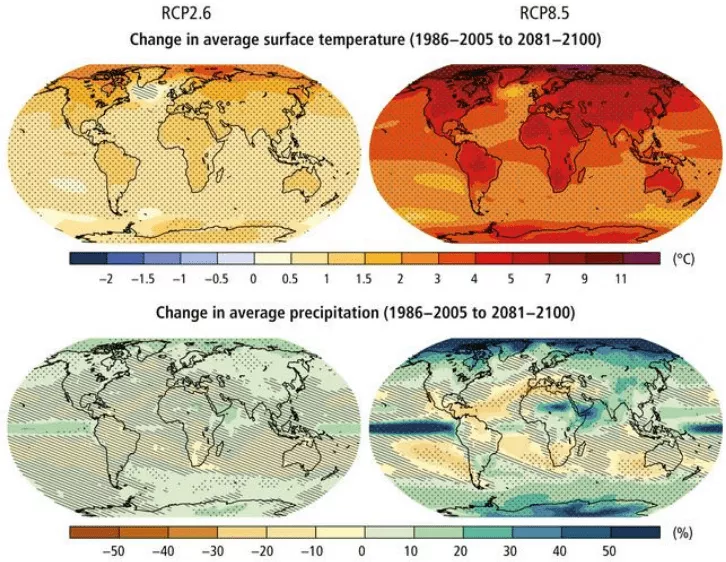
RCP8.5 (CMIP5) (IPCC, 2014). Note: precipitation changes in Europe are strongly linked with a shift of Hadley cell northward.
5. Very strong (and deadly) start of Hurricane 2025 season
Strengthening La Nina and AMO+ are the main predictors for the next above-average and deadly Hurricane season 2025. It should mean more ex-tropical storms and ex-hurricanes at the end of Summer 2025 in North America, especially in the second half of the summer, mainly in the Florida, the Southeast region, and the East Coast, such as in the parts of the Caribbean, parts of Midwest, Northeast, or southeasternmost Canada. Some regions of Texas and Eastern Mexico should be partly drier than average.
Pacific hurricane season is forecast to be extremely strong in Hawaii, but weaker in Mexico, Central America and the Southwest (of the USA) thanks to La Nina and PDO- phase. Some above-average anomaly should be reached in central parts of eastern Mexico, but Baja California will be very cold and dry, such as many parts of Southwest, USA, without stronger monsoon manifestations. East Central America will be hot and relative very dry (the region has a lot of storms during the year, but the next season will be calmer) than average.
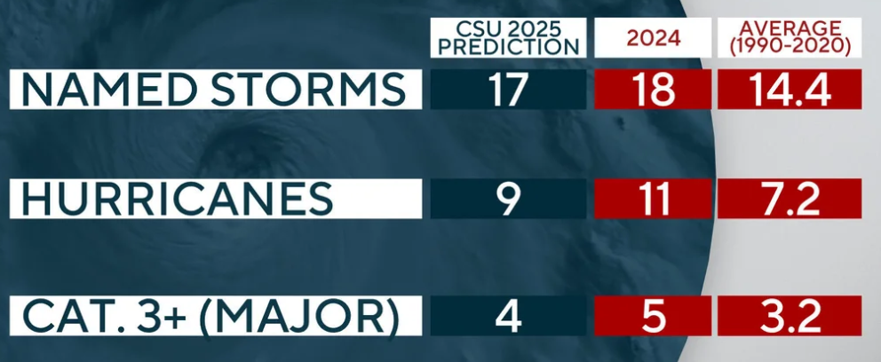
Source: https://www.cbsnews.com/news/2025-atlantic-hurricane-season-forecast/
6. Extremely strong Tornado 2025 season
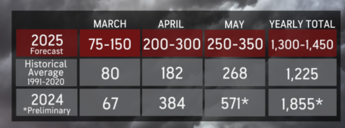
In 2025, approximately 500 tornadoes were reported until almost the half April – nearly double the historical average for this point in the year /https://www.accuweather.com/en/severe-weather/tornado-outbreaks-dramatically-accelerate-2025-season-one-state-stands-out/1763820/. Tornadoes will still occur in the Plains, but the Mississippi Valley could see significantly more severe weather activity. Parts East of Tornado Valley then will be bothered in 2025 very strongly by tornadoes in Spring and Summer 2025 /https://programbusiness.com/news/accuweathers-2025-tornado-season-forecast-what-to-expect//.
The 2024 tornado season with 1855 tornadoes reported, with 500 in May. By the end of May 2024, 1032 tornadoes – the second most on record from January to May – had been confirmed /https://www.weather.gov/news/250703_tornado_activity/. AccuWeather predicts a total of 1300 to 1450 tornadoes for the year 2025, still above the historical average of 1225, however, with a risk of severe derechos, mainly in the central parts of the eastern half of the USA and close Canada.
Tornadoes are stronger in the La Nina phase and anomalously high SSTs (sea surface temperatures) mainly in the Caribbean region, such as in North Atlantic and Eastern Pacific.
More detailed, El Niño, La Niña, and positive phase of SST anomalies in the Gulf of Mexico are linked to increased winter tornadoes; El Niño contributed to increased activity in the Southeast U.S., and La Niña increases tornado activity in the Midwest and Midsouth /https://www.nature.com/articles/s41598-021-81143-5/.
Positive phase of the NAO (lower than normal pressures over Greenland and higher than normal pressures over the Atlantic – the region of Azores high) is linked to a lower chance of tornadoes developing across southeastern states, Arkansas, Missouri, and Kentucky, therefore, these regions near negative NAO in Summer 2025 should have a stronger tornado season /https://www.nature.com/articles/s41598-021-81143-5/.
Positive phases of PDO, which was dominant from the mid-1970s until 2005, is associated with fewer tornadoes in the U.S. The Current PDO- outlook is favorable for tornadoes, too.
AccuWeather tornado 2025 forecast. Source: https://www.accuweather.com/en/severe-weather/severe-weather-tornado-forecast-for-us-in-2025/1749449
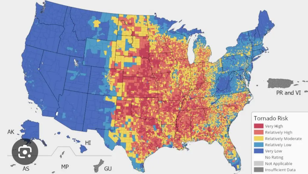
General tornado US map. Source: https://www.reddit.com/r/geography/comments/1cp8xr5/tornado_risk_map/
7. A melting Arctic with much escaping moisture
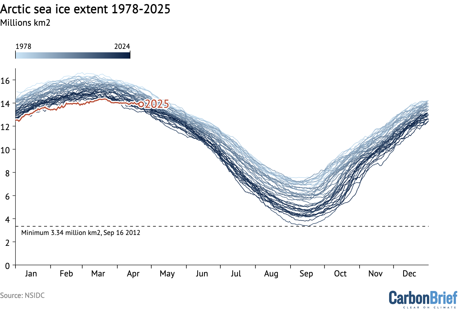
A declared 2025 Arctic sea ice extent winter maximum was the lowest on record, at 14.33 million km² (5.53 million mi²). That’s 80,000 km² (31,000 mi²) below the previous low seen on March 7, 2017.
La Nina means stormier Arctic than El Nino, with less high pressure anomalies, but NAO- and AO- blocking highs, despite La Nina, should in Summer 2025 still bring anomalous heatwaves far northward, even behind the Polar Circle during the following summer season, mainly above Canadian, north- and west-Alaskan and west-Greenlandic sectors of the Arctic.
In Icelandic and Greenlandic sector of the Arctic, however, should be observed an anomaly of Global warming hole, after the coldest summer – Summer 2024 – in the last 30 years in Iceland /https://www.icelandreview.com/news/coldest-summer-decades/?srsltid=AfmBOorxjZfz_LZ0AiJ4mHstHY6mZ7HT61tQigOVjPvXyJ_XUHKyafNx/.
Overall, anomalously wet and stormy northern Canada, parts of Alaska, and mainly eastern and southern Greenland are in Summer 2025 expected to be stormy (in the sense of “stormtrack”), mainly thanks to escaping moisture from the record warm Arctic Ocean. This mechanism is so-called Arctic Amplification, with the strengthening of the warming in the region as a positive climate feedback.

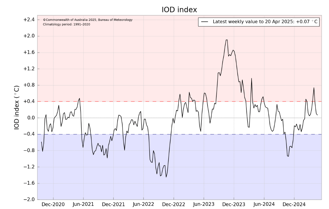
8. Negative IOD
The Indian Ocean Dipole (IOD) is defined by the difference in sea surface temperatures between the eastern and western tropical Indian Ocean.
Mostly neutral or slightly negative IOD index during Summer 2025 is expected.
IOD- correlates with La Nina and NAO-.
Correlates with La Nina and NAO- mean stormier chances for the eastern half and drier for western half of the continent.
The decline of the IOD index should be linked more with NAO- in the European sector.
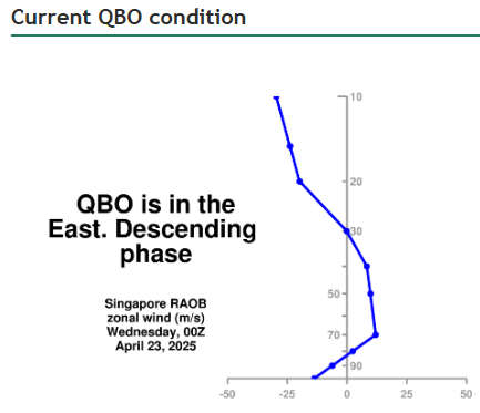
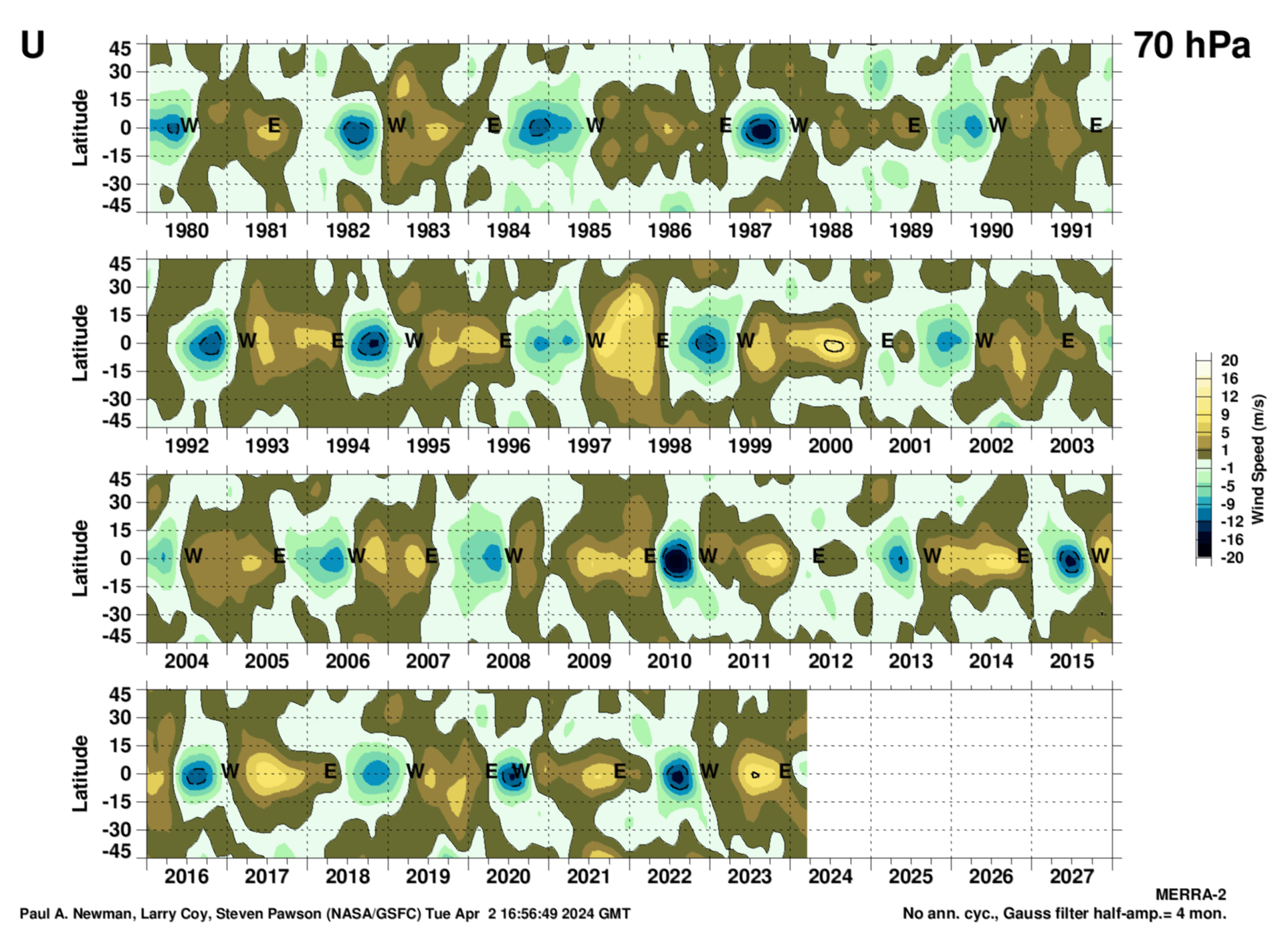
9. QBO Easterlies
More support for meridional airflow, including NAO- / AO- conditions in the Northern hemisphere and North America, thanks to a slow, gradual shift from Westerly to Easterly phase is expected in 2025, with a possible small and slightly increasing contribution to atmospheric blocking and heatwaves in North America in the second half of Summer 2025.
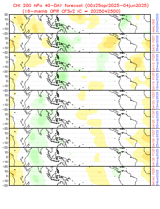
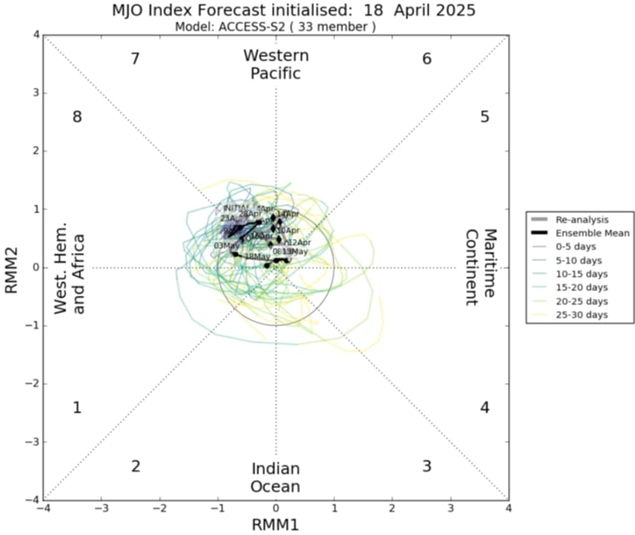
10. MJO
In April and May we are / will be in MJO phases 7, 8, and 1, which means potential to links to NAO- patterns, however MJO signal is weak (in the circle).
In the next 40 days – until 5. May 2025 will be MJO wet in North American sector, then 5.-25. May dry and from 25. May to 5. June 2025 again slightly wet, with a chance of very weak disturbances in the Caribbean region or Central America.
11. AMO+
11. AMO+
Warmer seas near North America, together with La Nina, NAO-, PDO- with effect on stronger hurricane season and ex-tropical disturbances, especially in late Summer 2025.
Despite the forecast weakening of the AMO+ phase in Summer 2025, and regenerating in Autumn 2025, still very warm SSTs above the Atlantic should produce a very dangerous Hurricane season 2025 /https://climateimpactcompany.com/february-2025-enso-pdo-amo-and-iod-outlook-2-2//.
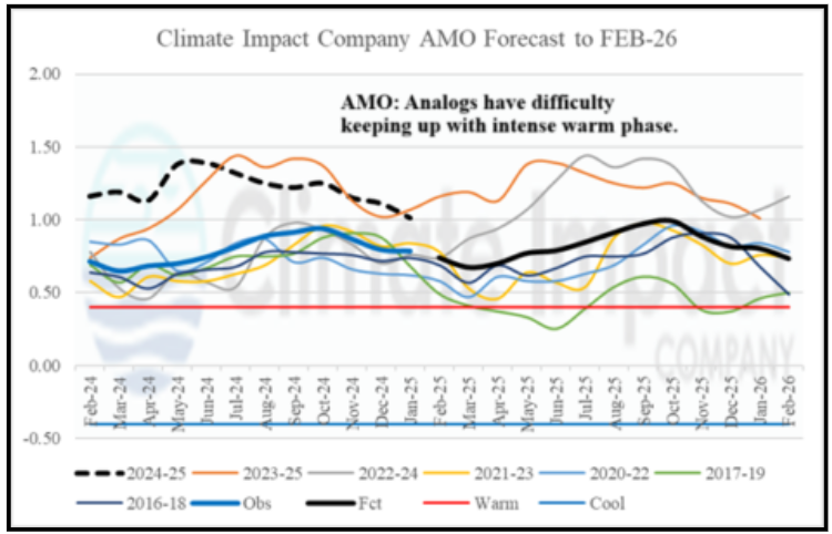
AMO outlook. Source: https://climateimpactcompany.com/february-2025-enso-pdo-amo-and-iod-outlook-2-2/
12. PDO–
Negative phase of PDO in combination with La Nina will be linked with “Heat Domes” above western parts of the USA and SW Canada, often with basis in hot air masses above Mexico.
Baja California region however, will be thanks to PDO- very cold and dry.
Parts of southwestern Alaska should be stormy.
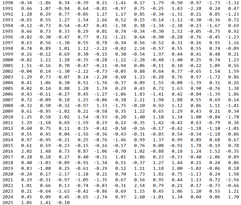
Evolution of PDO index. Source: https://www.cpc.ncep.noaa.gov/products/precip/CWlink/pna/norm.pna.monthly.b5001.current.ascii.table
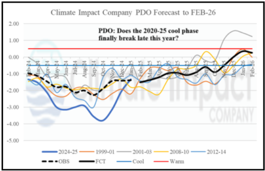
PDO forecast. Source: https://climateimpactcompany.com/february-2025-enso-pdo-amo-and-iod-outlook-2-2/
13. PNA–
Reverse pattern (PNA-) of “wet West” and “dry East” is evoking PNA+ phase, and PNA will be really in the negative phase, with changes caused by global warming; however, its impact on western parts of the continent will be in summer time significantly reduced.
It should be linked with a partial weakening of an anomaly of NW USA and British Columbia / Alberta “Heat Domes”.
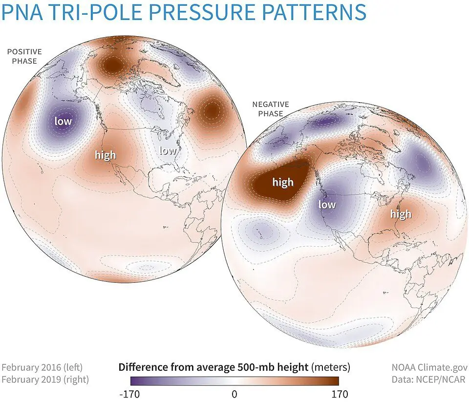
PNA phases. Source: https://en.wikipedia.org/wiki/Pacific%E2%80%93North_American_teleconnection_pattern
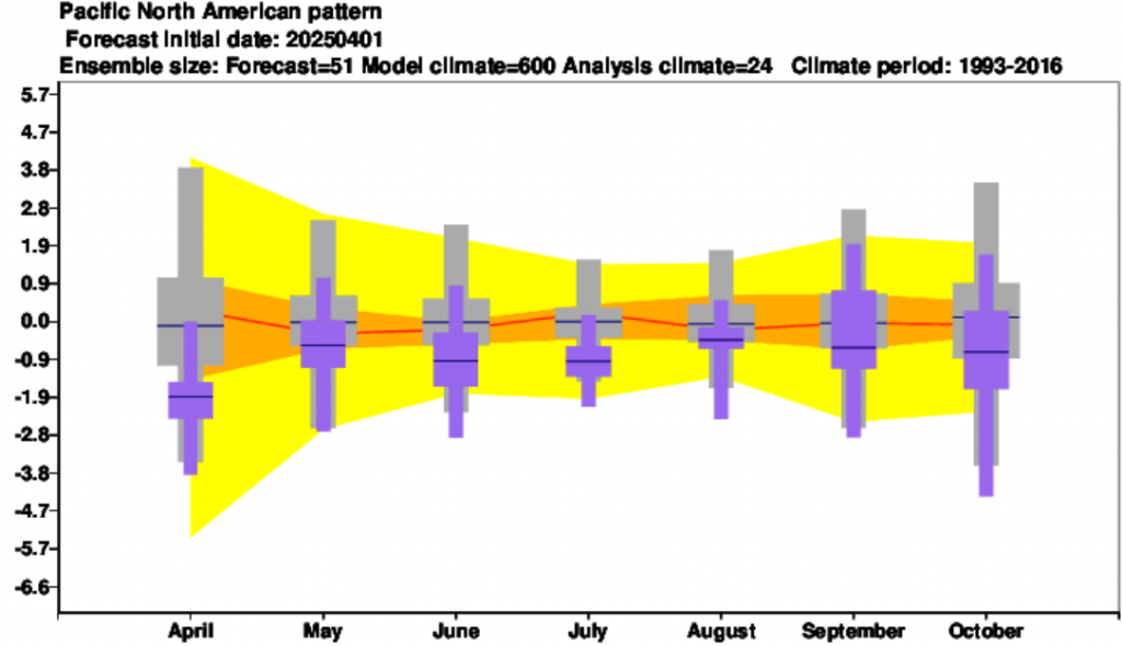
PNA forecast. Source :https://charts.ecmwf.int/products/seasonal_system5_climagrams_teleconnection?base_time=202504010000&index_type=Pacific%20N.Amer%20pattern
14. “Heat domes”
Historic Heat Dome in 2021 in Canada brought anomalous +49,6°C in Lytton, British Columbia.
Tropical Pacific Diabatic heating due to El Nino-like warming pattern will enhance this circulation, with the extreme heatwave risk over the Pacific Northwest.
In Summer 2025, the main driver of heat domes above the region will be PDO- phase.
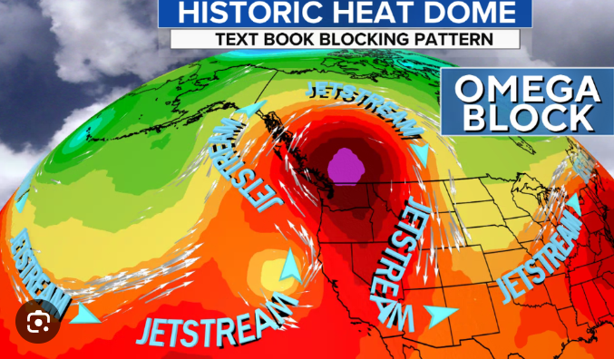
Heat dome in SW Canada in 2021. Source: https://www.cbsnews.com/news/heat-wave-dome-2021-seattle-portland-weather/
15. SSTs
Mostly warm SSTs along the southern and eastern USA should be associated with stronger storm (and hurricane) activity.
Colder Pacific coast near Mexico and Central America should be linked with weaker Pacific Hurricane season 2025.
Waters near Greenland are linked with GW hole southward from Greenland, from melting fresh water in the region.
A colder anomaly is detected above northern Alaska, northern Greenland, and westward from Baffin Island, but Hudson Bay, Labrador region, and most of northern Canada seas will be warmer, with strong Arctic sea ice melting.
Blocking anticyclone above the Arctic is during to El Nino much stronger.
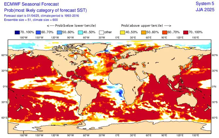
SSTs forecast for JJA 2025 (Summer 2025). Source: https://charts.ecmwf.int/products/seasonal_system5_standard_ssto?area=GLOB&base_time=202504010000&stats=tsum&valid_time=202506020000
16. GW hole southward from Greenland
Still very important signal of melting Arctic.
Should be linked with colder summer in parts of Greenland or Iceland as we mentioned before, with summer cold blasts with temporary snowing.
Thanks to La Nina, a lot of precipitation above parts of Greenland is in Summer 2025 expected.
In the case of the full shutdown of AMOC and Gulf stream, a significant regional cooling from easternmost Canada to northern and western Europe is in the next decades not fully excluded (map below).
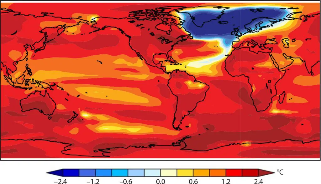
Global warming hole spreading in he case of the collapse of the Gulf Stream throughout the 21. century. Source: https://tos.org/oceanography/article/is-the-atlantic-overturning-circulation-approaching-a-tipping-point
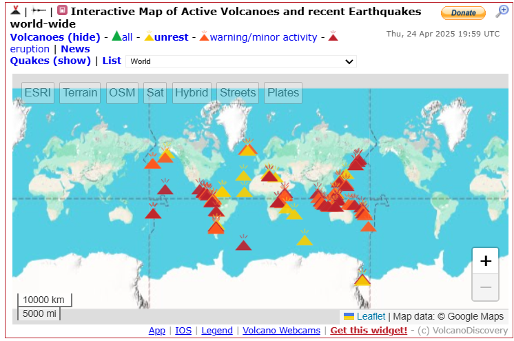
17. Volcanoes
Volcanoes in Central America and Mexico, Hawaii, and near Alaska should have a local, maximally regional effect on temperature or cloudiness in North America in Summer 2025, in case of stronger eruptions, with higher VEI.
Similar or lesser effects of the possible very strong eruption across “The Ring of Fire” on the weather in North America, especially through global temperature fluctuations.
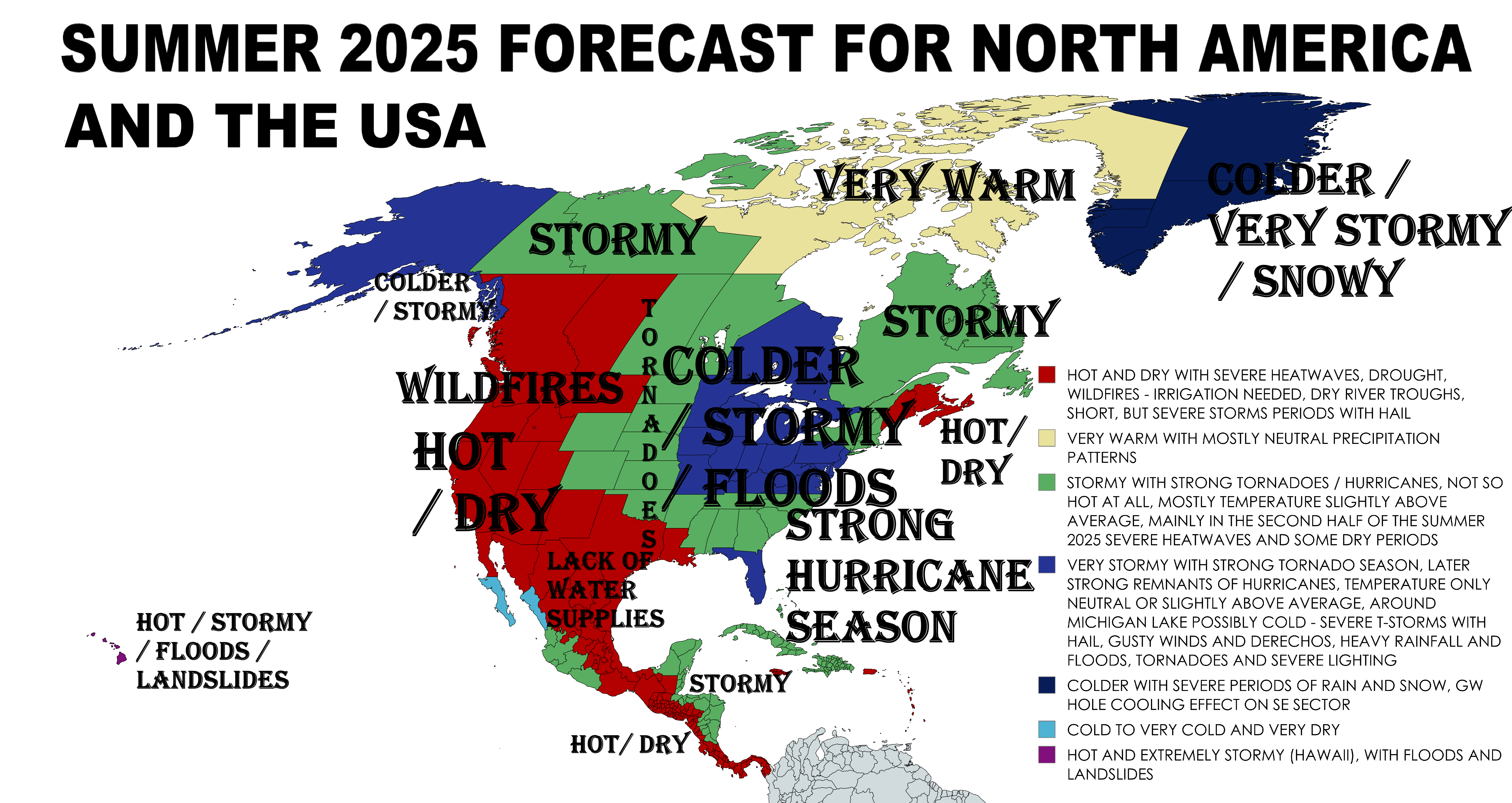
Now, we should look at the 8 main sectors on the forecast map for Summer 2025 for North America and the USA, with similar regimes of weather:
A) HOT AND DRY (WESTERN HALF OF THE CONTINENT, CENTRAL AND PARTS OF EASTERN MEXICO, WESTERN CENTRAL AMERICA, MAINE, NEW BRUNSWICK AND NOVA SCOTIA – DARK RED): Mostly dry and hot Western USA, British Columbia, Alberta, Mexico, Central America – this anomaly should be spreading from Mexico and Southwestern USA gradually northward, with possible severe heatwaves in SW Canada (Hadley Cell, Atmospheric blocking and Heat Domes). Possible heatwaves up to +50°C in populated parts and +55°C in Death Valley during the peaking summer, problems with drought, wildfires, in agriculture and water supplies, especially in Mexico. Possible deadly heatwaves. Very strong wildfire season. Sporadic storm periods. Support of PDO-. Mexico with a possible all-time summer highs above the central plains, Central America drier as usual, with a weaker Pacific hurricane season. Southwestern monsoon calmer, too. In Maine, New Brunswick, and Nova Scotia a little warm and dry anomaly in comparison of the rest of the Northeast.
B) VERY WARM WITH MOSTLY NEUTRAL PRECIPITATION PATTERNS (WESTERN GREENLAND, EASTERN CANADIAN ARCTIC – YELLOW): Mostly low geopotential above the Arctic during summer, but some parts should be dry, with possible heatwaves up to +25°C, alternating with storms. A drier region mainly in western Greenland and eastern North Canada. Stronger continental and sea ice melting as in eastern Greenland and western North Canada and Alaska, still with anomalous flow of fresh water into the North Atlantic.
C) STORMY WITH SEVERE TORNADO AND HURRICANE SEASON (EASTERN HALF OF THE USA EXCEPT OF MIDDLE PART, WHERE COLDER AND MORE SEVERE, THE GREAT LAKES REGION, PARTS OF WESTERN ADN EASTERN COAST OF MEXICO AND NORTHEASTERN CENTRAL AMERICA, RAINY NORTHERN CANADA – GREEN): La Nina / AMO+ / PDO- more fertile, but floody, tornadic and hurricanic – sudden start of the Hurricane season 2025 in Atlantic sector, after peaking of Summer 2025 in their second half, is possible. Tornadoes probably stronger in the first half of the season, mainly above the Midwest or the Southeast. Temperature anomalies therefore lower than on the West, but still hot except for the central (blue) area in the middle. Temperatures up to +45°C in the south, and up to +40°C in the north of the USA and southernmost Canada during drought and heatwaves. Northeasternmost Central America stormy thanks to busier tropical hurricane activity from the North Atlantic, similarly, the central-west coast Mexican sector above the Pacific. Possible above-average derechos, MCSs, strong supercells with tornadoes F3+, floods, lightning, large hail, heavy rains, and gusty winds with fatalities and property losses. Later shorter – but severe heatwaves, at the end first hurricanes and ex-hurricanes. North Canada with escaping moisture from the Arctic and La Nina typically cloudy and rainy, still with a possibility of shorter, but intensive heatwaves above +30°C.
D) TEMPERATURE NEUTRAL, SLIGHTLY TEMPERATURE ABOVE AVERAGE OR LOCALLY COLD AND VERY STORMY (CENTRAL PARTS OF THE EASTERN USA, THE GREAT LAKES REGION, FLORIDA, PARTS OF ALASKA): Pressure trough from central Canada and the Arctic up to Florida, with colder summer than expected, with mostly slightly warmer than average, regionally temperature neutral, locally even colder than long-term average. Stormier, with many tornadoes, mainly the first half of Summer 2025, then a relatively hot second half. Strong Tornado, later the first greetings of the strong Hurricane 2025 season. La Nina / AMO+ / PDO- more fertile, but floody, tornadic and hurricanic – sudden start of the Hurricane season 2025 in the Atlantic sector, after peaking of Summer 2025 in their second half. Tornadoes probably stronger than in the Midwest, especially eastward from Tornado Valley. Temperature anomalies therefore lower than on the West. Temperatures up to +45°C in the south, and up to +40°C in the north of the USA and southernmost Canada during drought and heatwaves. Possible above-average derechos, MCSs, strong supercells with tornadoes F3+, floods, lightning, large hail, heavy rains, and gusty winds with fatalities and property losses. Later shorter but severe heatwaves, at the end, first hurricanes and ex-hurricanes. Alaska affected by moisture from the Pacific like a result of La Nina / PDO- / PNA-, QBO shifting to Easterlies,…configuration. The most of precipitation and storms in inhabited southeastern Alaska
E) VERY COLD AND VERY DRY (BAJA CALIFORNIA REGION, MEXICO): La Nina and PDO- configuration causes very cold and very dry Baja California, mainly its southernmost parts, still with temperatures up to +50°C above deserts. It means extremely weak Pacific hurricane season for the region.
F) COLDER, VERY STORMY AND SNOWY EASTERN AND SOUTHERN GREENLAND: After the coldest summer in parts of Iceland in 30 years /https://www.ruv.is/english/2025-01-21-2024-was-unusually-cold-in-iceland-433720/, with record low pressure and anomalous rain- and snowfall, SE Greenland and parts of Iceland should face the next colder summer season, with anomalous rainfall / snowfall. These changes are mostly associated with the Arctic Amplification mechanisms and creating a Global warming hole in SSTs and air temperatures, so far, in the North Atlantic, linked with Arctic freshwater melt. La Nina is moreover linked with more cloudy and stormy Arctic, while El Nino brings more blocking highs above Greenland. Low pressure near Iceland will be forcing against NAO-/AO- pattern, but it should be overall preserved. Temperatures up to +20°C, maybe +25°C in southernmost Greenland during the peak of summer.
G) EXTREMELY STORMY AND HOT HAWAII: Anomalously stormy Summer 2025 with very warm conditions is expected, with a possibility of floods and landslides, such as heavy storms and rains, with highly above-average occurrence of tropical depressions, storms, and hurricanes. Effects of ENSO and PDO on weather patterns in Hawaii you will find here: https://ui.adsabs.harvard.edu/abs/2012AGUFM.B13B0502F/abstract.
Summer 2025 forecast for Europe you will find here: https://mkweather.com/summer-2025-forecast-for-europe/
Mkweather Summer 2025 forecast for North America. Base map: https://mapchart.net/europe.html
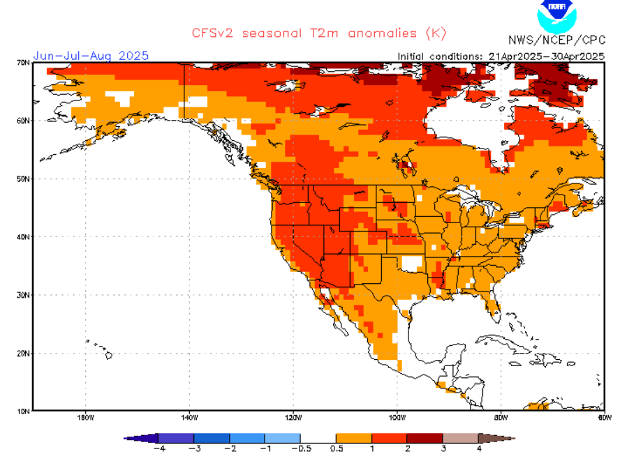
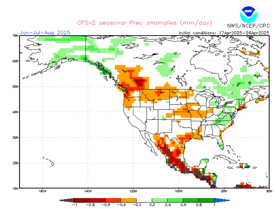
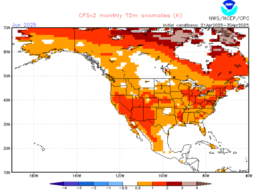
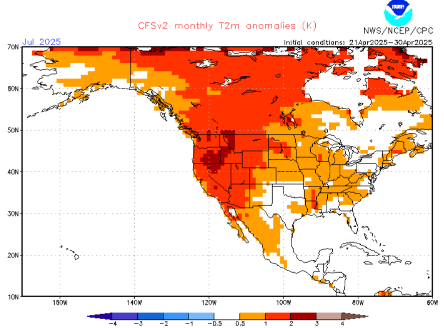
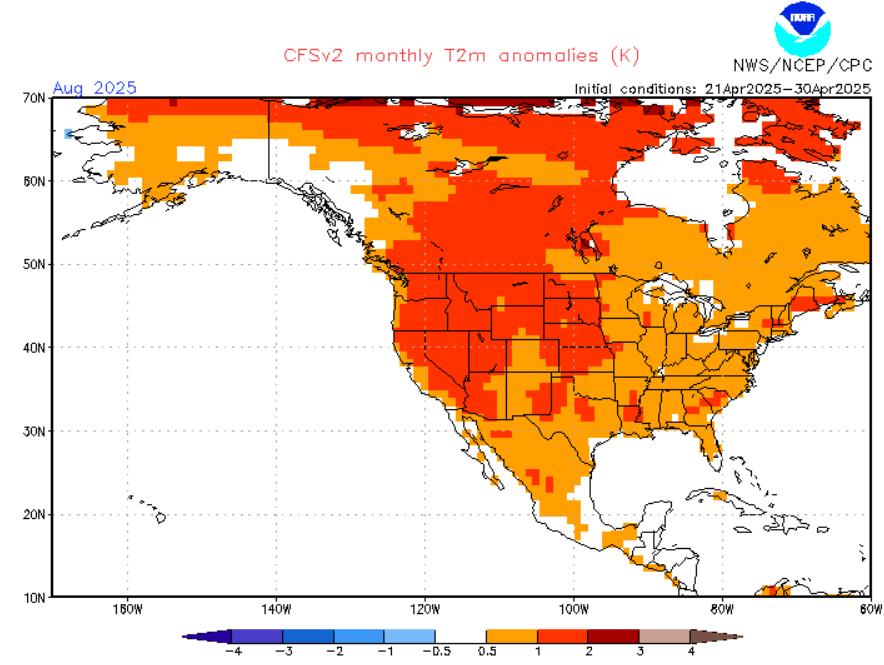
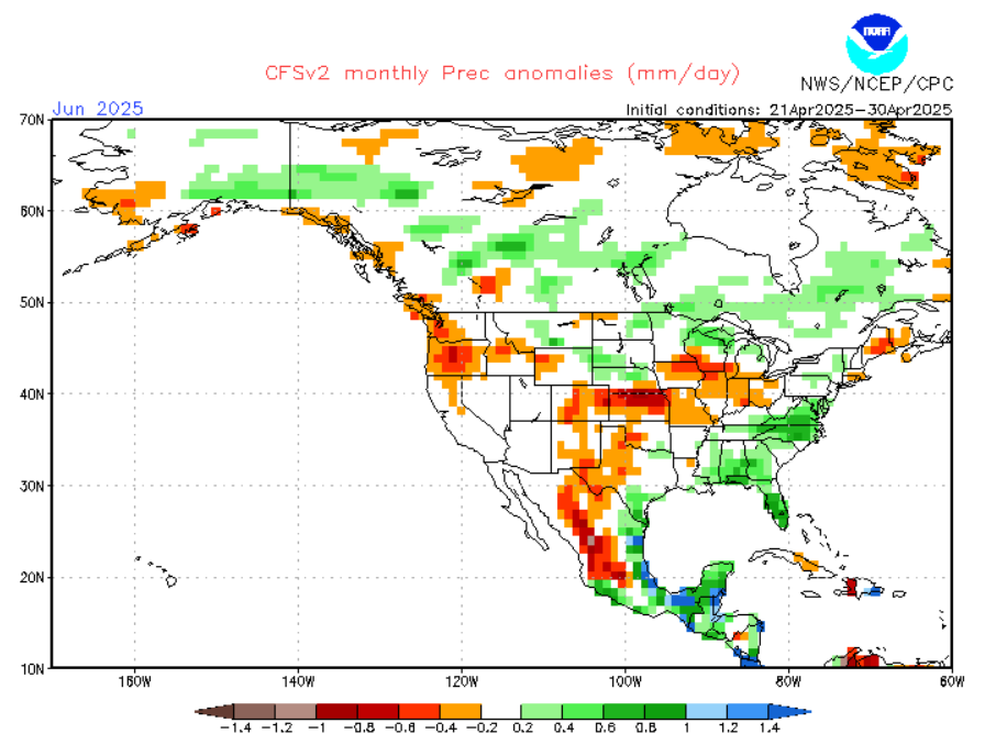
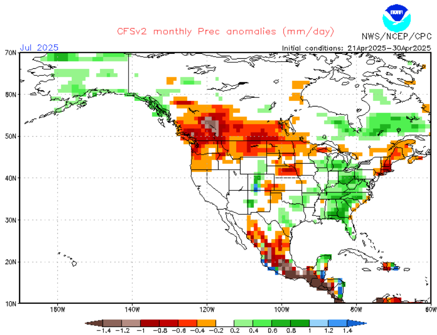
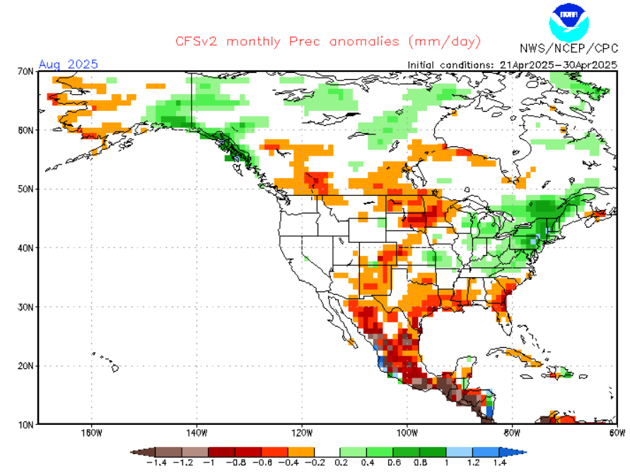
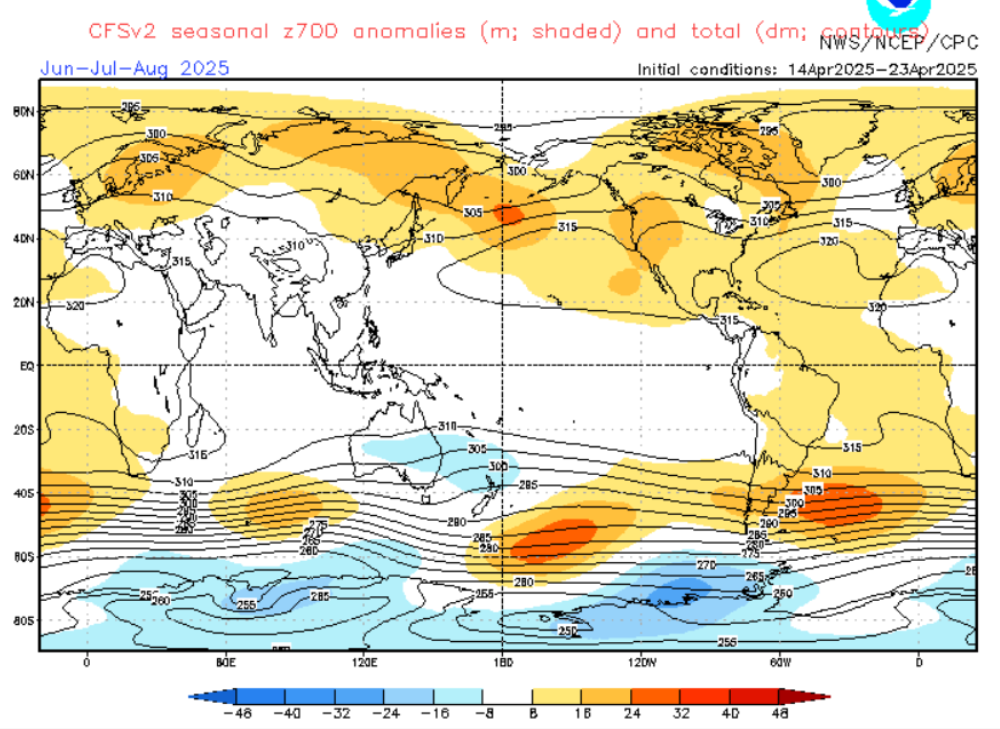
CFSv2 forecasts for Summer 2025. Source: https://www.cpc.ncep.noaa.gov/products/CFSv2/htmls/glbz700e3Sea.html
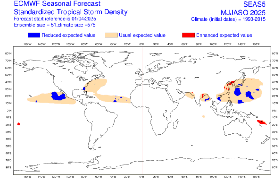
ECMWF forecast for Summer 2025 and Tropical storms activity in the next half-year. Source: https://charts.ecmwf.int/?facets=%7B%22Range%22%3A%5B%22Long%20%28Months%29%22%5D%7D
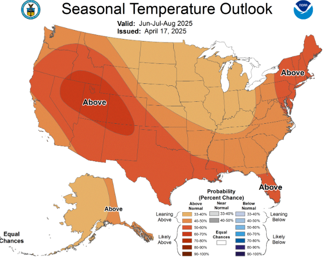
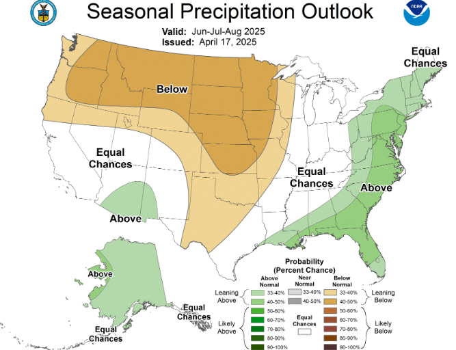
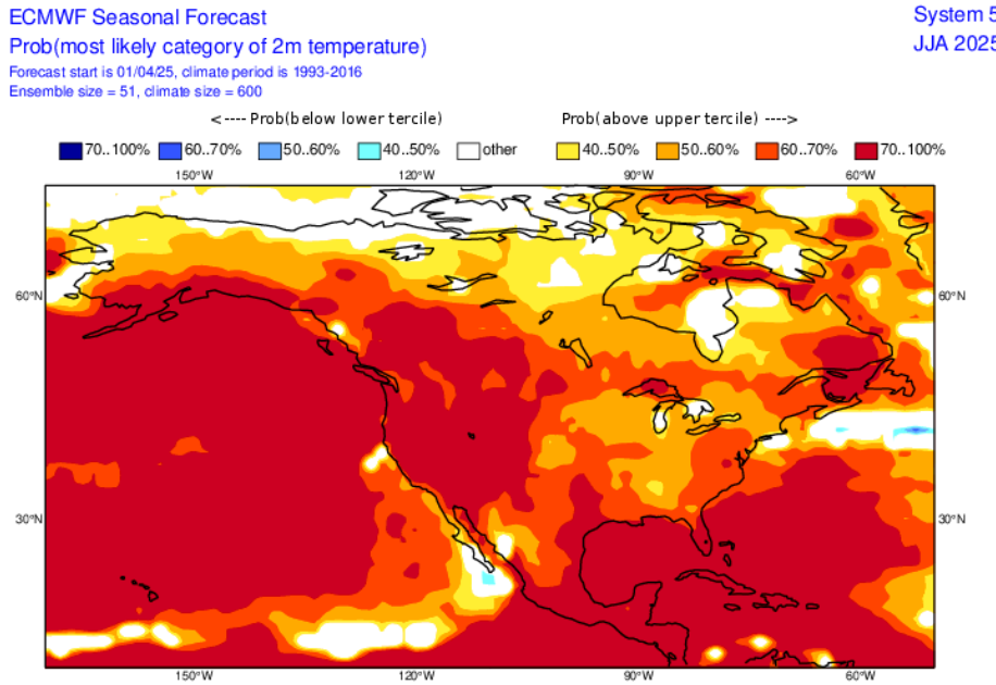
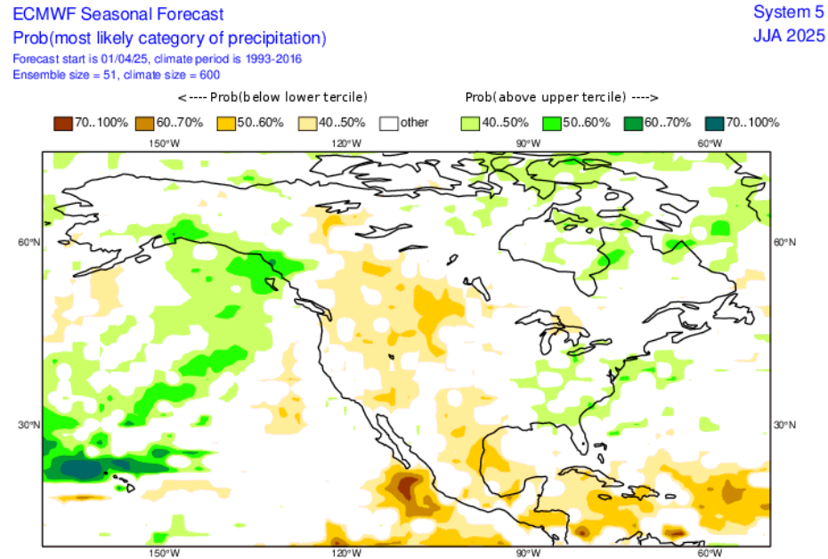
Outlook from NOAA for Summer 2025: https://www.cpc.ncep.noaa.gov/products/predictions/long_range/seasonal.php?lead=2
Acknowledgments: Special thanks to Julius Subovic as a consultant near the writing of all MKweather seasonal forecasts for Summer 2025 /https://www.facebook.com/share/1BLmUMAPof//


6 thoughts on “SUMMER 2025 FORECAST FOR NORTH AMERICA AND THE USA: AT THE FIRST HALF MORE FLOODS, AT THE SECOND HALF PEAK OF THE SUMMER – STRONG WILDFIRE SEASON ON THE WEST, DEADLY TORNADO AND HURRICANE SEASON ON THE EAST”