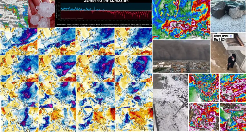
Weather report for 5. May 2025: Coldwave in Europe will last long 2 weeks, bringing snow and frosts (Sweden -10,5°C, Finland -10,4°C, the UK -2,9°C, Poland -1,7°C, the Netherlands -1,4°C, Denmark -1,3°C, Baltic countries -1,3°C, Germany -0,4°C), frosts below -5°C in basins and valleys possible on snowfall up to 5 cm below 1000 MASL, severe storms in Southern Europe expected, France and Italy already with 5 cm hail and floods / Canada +32,5°C, the US from cold and stormy to hot and dry pattern next weeks / Sandstorm in Saudi Arabia and heatwaves in the Middle East and Central Asia, flooded Dimona, Israel, hail in Guanzhou, China / Hewataves in Bolivia, South Africa and Australia / Anomalously cold Arctic
Europe
After a historic snowfall in Moscow, heatwaves in Europe and shift of a cold front above Europe southeastward in the last days /https://mkweather.com/weather-report-04-05-2025/; https://mkweather.com/weather-report-for-may-3rd-2025-unseasonal-heat-in-central-continental-europe-30c-in-austria-and-hungary-high-temps-along-mid-atlantic-us-seaboard-31c-in-virginia-and-maryland-midd/; https://mkweather.com/weather-report-for-1-may-2025-continental-europe-after-tropical-heatwave-frosts-and-snow-in-basins-finland-102c-the-netherlands-295c-germany-288c-severe-storms-hit-easter//, severe coldwave is already here on Monday 5. May 2025, with a very long and cold outlook for parts of Europe.
In some regions, the Arctic air should persist above the same region until cca 18. May 2025, which is together from 4.-5. May 2025 long almost 15 days.
During this period, severe frosts should appear regionally in lowlands, too, and basins and valleys in the mountains around 300-800 MASL should report even lower temperatures, below -5°C, locally up to -10°C.
Moreover, in relatively lower situated areas in valleys 500 – 1000 MASL in the Alps, or the Carpathians, snowfall around 5 cm, maybe locally up to 10 cm is possible during the first half of May 2025, which should accelerate dropdown of temperatures during subsequent clear nights.
Already on 5. May 2025 was in many parts of Europe very cold:
While SE secotr Europe reported tropical days – Calarasi, Romania +30,3°C, Bucuresti +28,6°C, Scandinavia was very cold – Naimakka in Sweden reported -10,5°C (but 30.4. -19,0°C), Enontekio in Finland -10,4°C (but 30.4. -18,2°C), Tulloch Bridge, the UK -2,9°C, Cairnwell, the UK -2,6°C, Los Glascarnoch, the UK -2,5°C, Bala / Strathallan, the UK -2,0°C, Gurteen, Ireland -0,3°C, Tirstrup, Denmark -1,3°C, Aarhus, Denmark -1,0°C, Twenthe, the Netherlands -1,4°C, Deelen, the Netherlands -1,3°C, Fichtelberg, Germany -0,4°C, Resko, Poland -1,7°C, Kuusiku, Estonia -1,3°C, Stende, Latvia -1,2°C, Karlovy Vary, Czechia +0,3°C.
Very impressive were maximum temperatures below +10°C, locally only +3/+5°C in regions below 1000 MASL, even, around +5/+7°C in lowlands in continental Europe:
Belach na Ba, the UK, 773 MASL, Tmax +3,8°C (4.5.) , Mont Rigi, Belgium, 671 MASL +8,4°C (5.5.), Hohenpeissenberg, Germany, 977 MASL +6,7°C (5.5.) (3.5. +25,7°C), Oberstdorf, Germany, 806 MASL +8,9°C (5.5.) (3.5. +26,0°C), Cervena, Czechia, 748 MASL +5,5°C, Elblag Milejevo, Poland, 189 MASL, +7,4°C, Gdansk, Poland, 7 MASL +8,6°C, Zakopane, Poland, 855 MASL +9,1°C, Suwalki, Poland, 184 MASL, +9,7°C, Liesek, Slovakia, 692 MASL, +9,4°C, Pakri, Estonia, 23 MASL, +6,2°C, Tallin, Estonia, 3 MASL, +7,0°C, Aluksne, Latvia, 198 MASL, +5,5°C, Riga, Latvia, 3 MASL, +9,3°C, Svencyonis, Lithunia, 221 MASL, +7,1°C, Vilnius, Lithuania, 211 MASL, +8,9°C, Dokshitsy, Belarus, 197 MASL, +6,9°C, Minsk, Belarus, 234 MASL, +8,3°C, Zurich, Switzerland, 556 MASL, +9,5°C.
On cold front, were in the last 24 hours impressive storms in France and Italy, with hail up to 5 cm and regional flash floods.
From bigger cities, in Lugano, Switzerland, 103 mm, in Lyon, France, 43 mm, in Innsbruck, 31 mm, in Davos, 29 mm, in Zurrich 28 mm and in Grenoble, 26 mm fell in the last 24 hours.
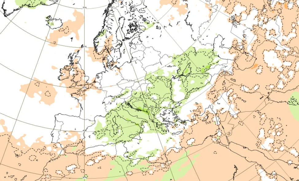
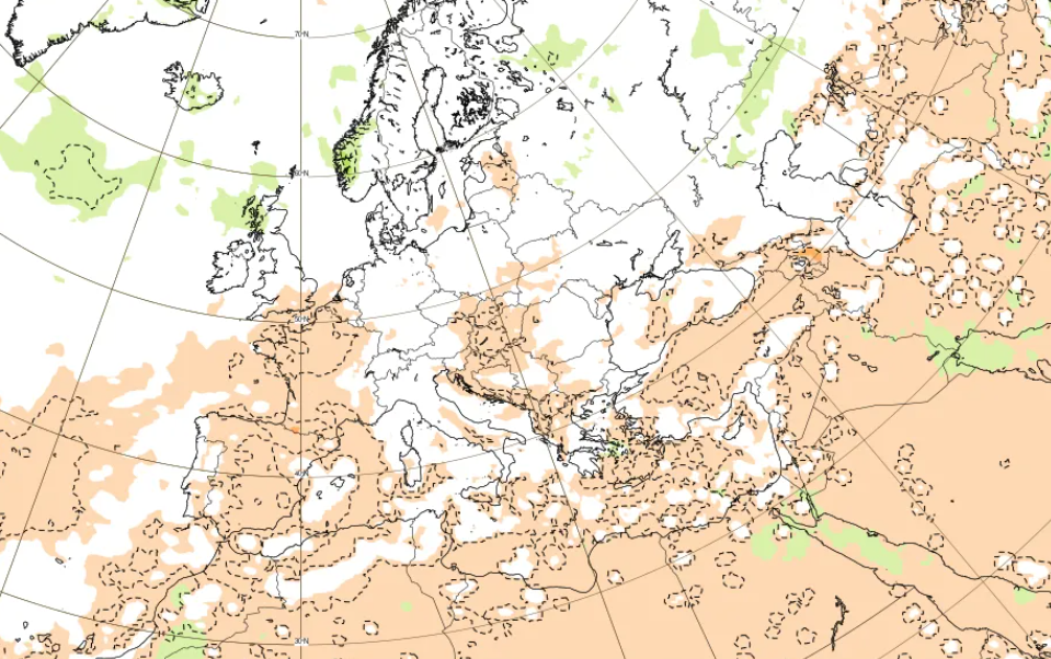
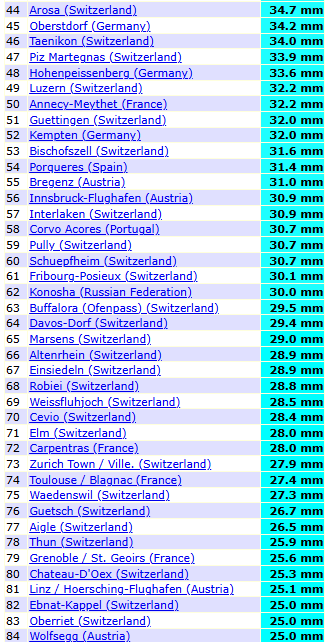
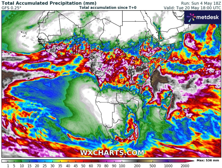
According to long-term forecast of accumulated precipitation in Europe until 20. May 2025, Southern Europe expects really heavy rainfall and storms next 16 days, from Pyrenees and southern France to the Black Sea region, with a possibility of floods or severe storms, including tornadoes.
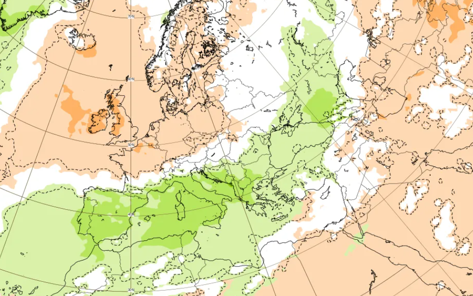
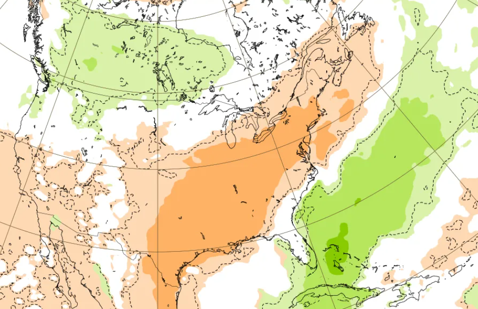
As we mentioned in outlook in the last article /https://mkweather.com/weather-report-04-05-2025//, heatwaves will return to Europe after 20. May 2025 and at the first half of June 2025, although, according to Mkweather Summer 2025 forecast /https://mkweather.com/summer-2025-forecast-for-europe//, stormy first half of summer is expected mainly in western half of the continent. In the second half of summer, the peak of the season is expected.
A current position of cold front. Source: https://www.accuweather.com/

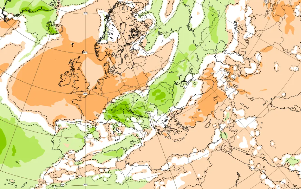
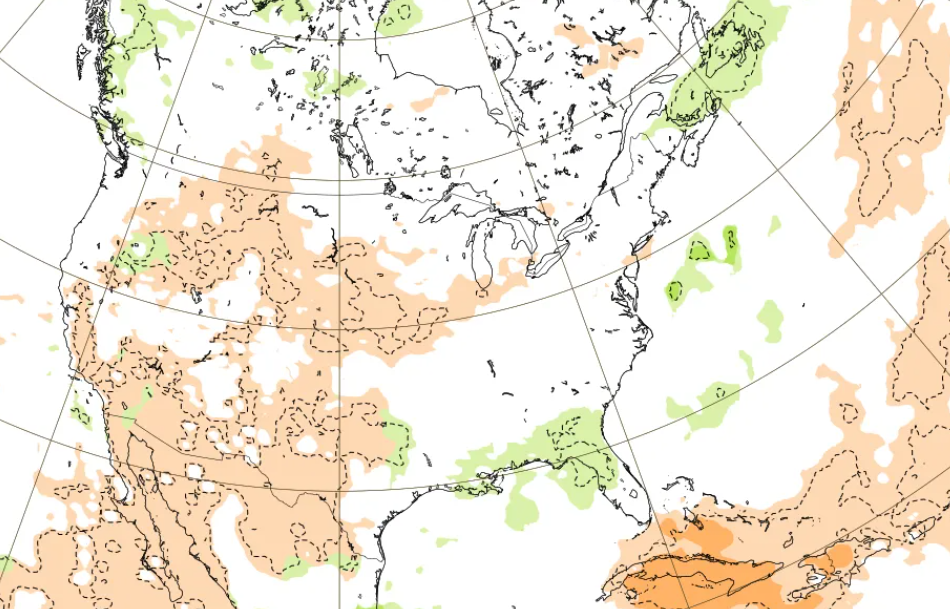
16-day temperature anomaly forecast for Europe (5.-20.5.2025). Source: https://www.wxcharts.com/
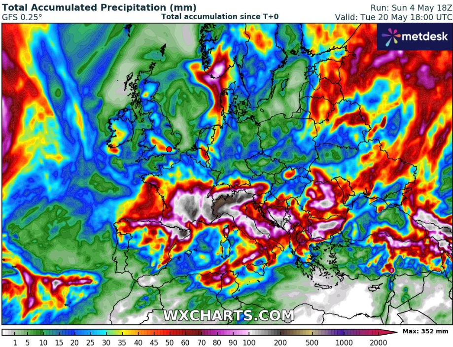
Accumulated precipitation in Europe until 20. May 2025. Source: https://www.wxcharts.com/
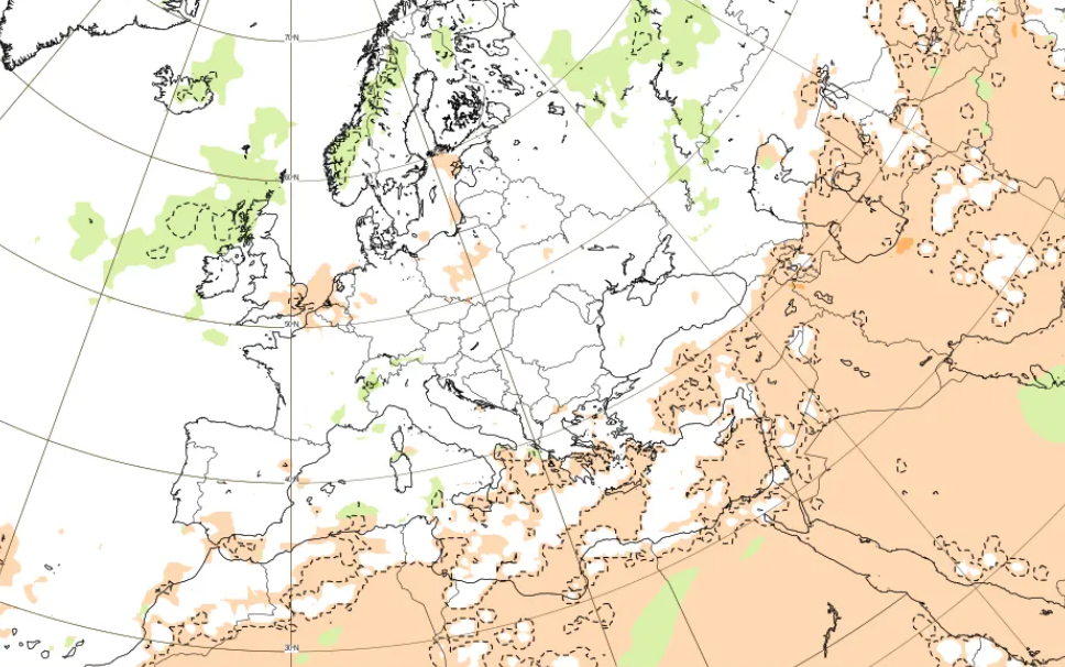
Precipitation forecast for Europe per weeks between 5.5. – 16.6. 2025. Source: https://charts.ecmwf.int/products/extended-anomaly-tp?base_time=202505040000&projection=opencharts_europe&valid_time=202506160000
FLOODS AND UP TO 5 CM HAILSTORMS IN FRANCE AND ITALY (INCLUDING 4CM HAIL IN LYON
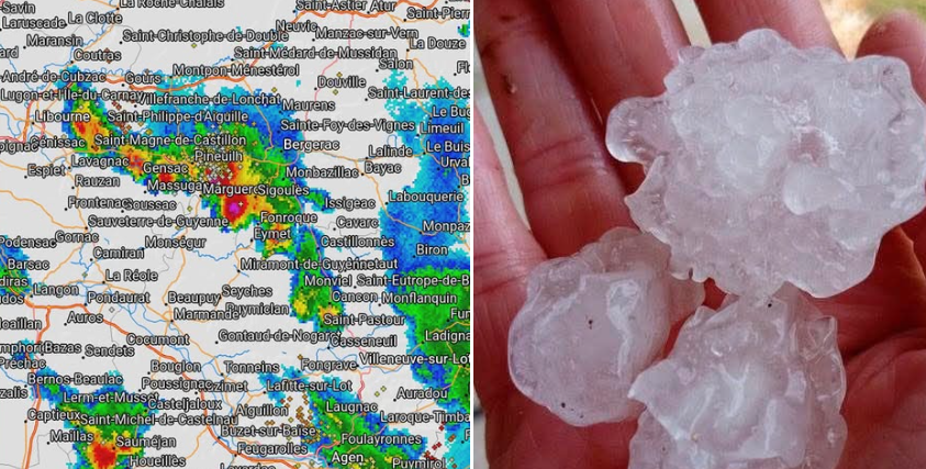
Extreme hailstorm up to 5 cm in Bergerac, France. Source: https://www.facebook.com/MeteoDordogneLive/posts/pfbid02h1weV6k5cHVqsjLooYgNYUjPySfLdiH4C2oyYFXKaLGBZ19o4A1WU3LTqncrPXKgl
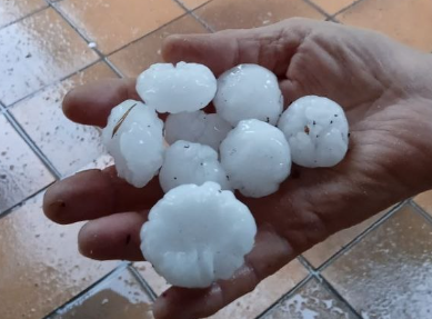
Mirano, Veneto, Italy, 4 cm hail. Source: https://stormreport.meteonetwork.it/asset/photo/28051_1746456236.4894.jpg

San Giorgio Canavese Piemonte, Italy, after 76,5 mm. Source: https://www.quotidianocanavese.it/cronaca/san-giorgio-canavese-temporale-maltempo-danni-acqua-case-allagate-55069?
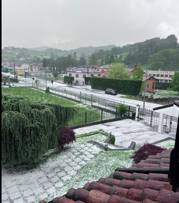
After hailstorm in Vicoforte, Piemonte, Italy. Source: https://www.facebook.com/photo/?fbid=692130526664149&set=a.200568545820352
Severe hailstorm near Lyon, France. Source: https://www.leprogres.fr/environnement/2025/05/03/intemperies-a-lyon-la-ville-recouverte-par-la-grele?at_content=video&at_term=leprogres.lyon&at_source=nonli
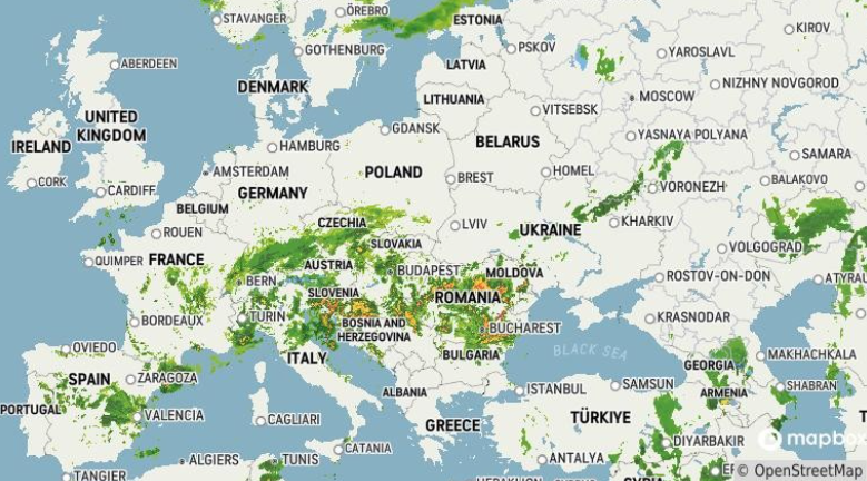
MANY STATIONS ACROSS EUROPE WITH PRECIPITATION OVER 25 MM ON 5. MAY 2025
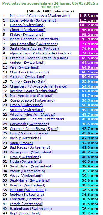
Source: ogimet.com
North America
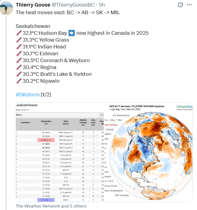
Hudson Bay station in Canada on 5. May 2025 surprised by tropical temperature of +32,5°C / 90°F, which is the highest temperature measured in Canada in 2025, and the first 90°F of the season. Yellow Grass reported +31,3°C and Indian Head +31,1°C.
Parts of eastern half of the USA hit promised severe storms – e.g. in Indiana, Pensylvania, 2 inches / 5cm hail was falling.
From storm news we have choosen:
- Surveys after deadly storms in Oklahoma, Texas, Missouri: https://weather.com/storms/severe/video/deadly-easter-storms-oklahoma-texas-missouri
- Home shredded after Missouri storms: https://weather.com/storms/severe/video/easter-storm-damage-missouri-guthrie-callaway-county-tornado
- Rain and storms settle in across Northeast: https://weather.com/storms/severe/video/severe-weather-flood-northeast-forecast
- Severe storms and flooding potential continues on the South: https://weather.com/storms/severe/video/severe-weather-flood-hail-wind-south-texas-forecast
- A blocking pattern meaning heavy rain and possible storms will linger for a large portion of the South and Northeast: https://weather.com/storms/severe/news/2025-05-04-plains-south-northeast-storms-rain-flooding-severe-forecast
- Baseball-Sized hail blasts hotel in Nebraska: https://weather.com/storms/severe/video/fremont-nebraska-hailstorm-hotel-damage
- Storm leaves trail of destruction in Texas: https://weather.com/storms/severe/video/irving-texas-dallas-county-march-severe-storm
- Northeast: Days of showers and thunderstorms for some, heavy rain for others: https://www.accuweather.com/en/weather-forecasts/northeast-days-of-showers-and-thunderstorms-for-some-heavy-rain-for-others/1771663
- Soggy South Central states: Intense downpours to renew flooding risk: https://www.accuweather.com/en/weather-forecasts/soggy-south-central-states-intense-downpours-to-renew-flooding-risk/1771462
- Rounds of severe storms to impact Central, East US: https://www.accuweather.com/en/severe-weather/rounds-of-severe-storms-to-impact-central-east-us/1771344
- Omega block set to bring multiday flooding threat to central and northeastern U.S.: https://watchers.news/2025/05/05/omega-block-flooding-central-northeast/
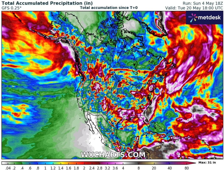
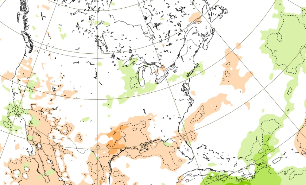
Flooding pattern on South and East is visible on the forecast of precipitation of ECMWF for North America for the first week (5.-11.5. 2025).
Then, a gradual warming and drying of the continent is predicted, with the first serious heatwaves in the USA and Canada.
Canadian Arctic and Greenlandic Arctic are currently showing a positive anomaly of the Arctic sea extent (a graph in the Arctic chapter), Mexico is, and mainly will be hot and dry, soon.
Mkweather Summer 2025 forecast for North America you will find here: mer-strong-wildfire-season-on-the-west-deadly-tornado-and-hurricane-season-on-the-eas/.
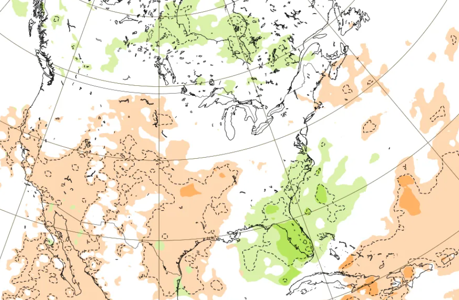
Accumulated precipitation in North America until 20. May 2025. Source: https://www.wxcharts.com/
Precipitation forecast for North America for the next 6 weeks per week (5.5. – 16.6. 2025). Source: https://charts.ecmwf.int/products/extended-anomaly-tp?base_time=202505040000&projection=opencharts_north_america&valid_time=202506160000
+32,5°C / 90°F IN CANADA
Source: https://x.com/extremetemps/status/1919277100743192984/photo/1
HAILSTORM IN INDIANA AND PENSYLVANIA UP TO 2 INCHES WIDE
Asia
Anomalous and historic heatwave across Asia, mainly the Middle East and Central Asia in the last weeks we detailed described in the last articles, with temperature records, of course: https://mkweather.com/weather-report-04-05-2025/, https://mkweather.com/weather-report-for-may-3rd-2025-unseasonal-heat-in-central-continental-europe-30c-in-austria-and-hungary-high-temps-along-mid-atlantic-us-seaboard-31c-in-virginia-and-maryland-midd/, https://mkweather.com/weather-report-for-1-may-2025-continental-europe-after-tropical-heatwave-frosts-and-snow-in-basins-finland-102c-the-netherlands-295c-germany-288c-severe-storms-hit-easter/, with temperatures up to +43,3°C in Central Asia (Turkmenistan) and +48,9°C in the Middle East (Kuwait) already in April.
The Middle East was in the last days set for the next round of heatwaves – Mind blowin Tmin of +38,5°C at Khassab Airport in Oman is a new world record for the hottest night on Earth for the period 1.-15. May, ever. Crazy Tmaxes are continuing in UAE and Iran, above +47°C.
Meanwhile, the massive sandstorm sweeping through Al Rass, Saudi Arabia.
In Dimona, Israel, a haistorm left behind a havoc in the last hours.
Severe hailstorm with floods hit Guizhou province, China, too.
Meanwhile in Japan, only summer ski resort reports record snowpack according to some sources.
According to accumulated rainfall forecasts, there are expected extremely stormy SE Asia and SE China, Koreas, Japan and Bangladesh until 20. May 2025, and dry India, Central Asia and the Middle East in raw estimate.
STORM FORECASTS FOR CHOSEN PARTS OF ASIA UNTIL 20. MAY 2025
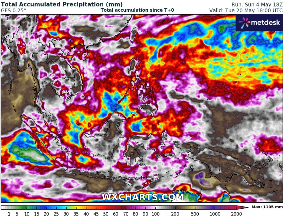
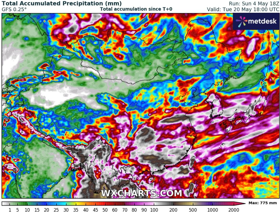
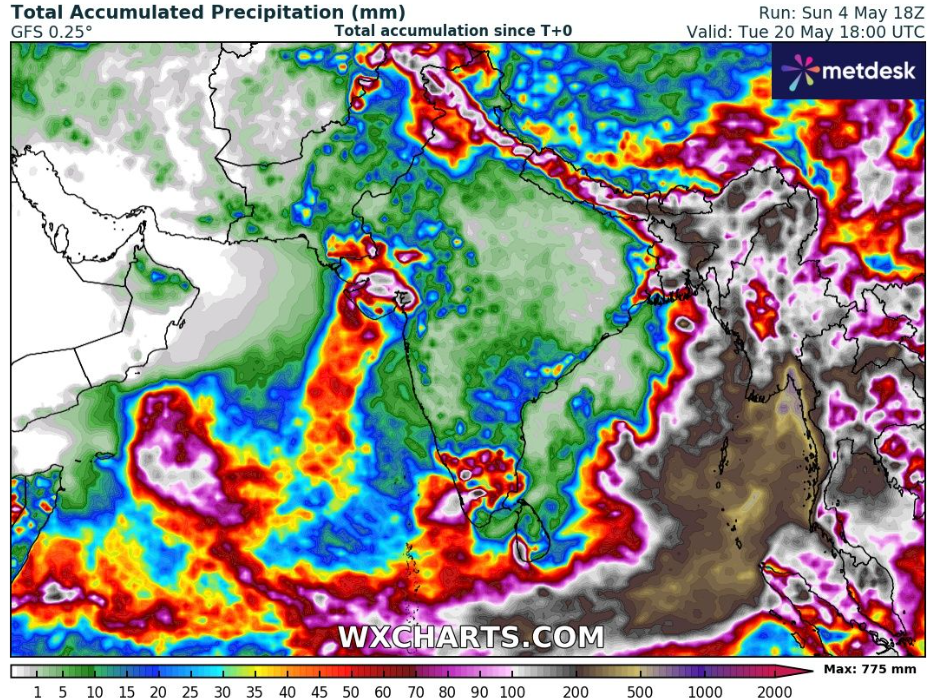
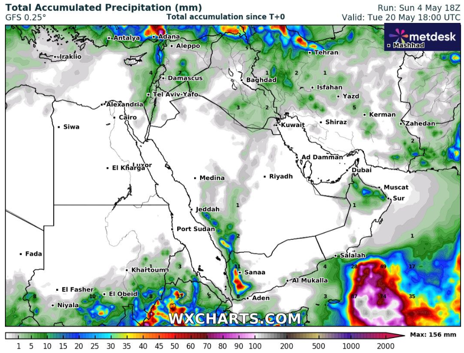
Accumulated precipitation in parts of Asia until 20. May 2025. Source: https://www.wxcharts.com/
HEATWAVES IN THE MIDDLE EAST
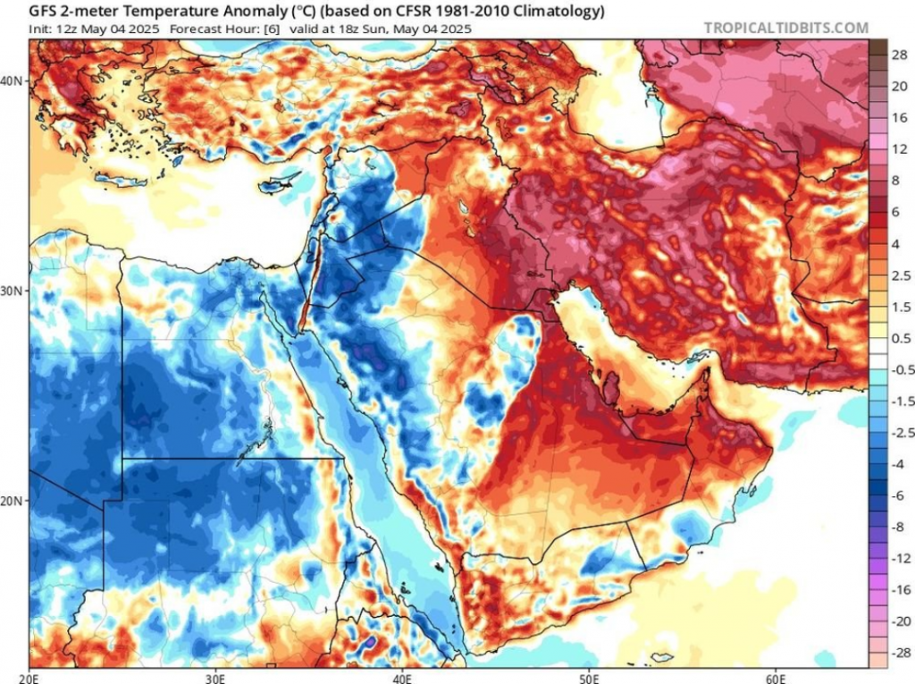
Source: https://twitter.com/extremetemps/status/1919372152723198189/photo/1
SAND STORM, AL RASS, SAUDI ARABIA
HEAVY RAINFALL, DIMONA, ISRAEL
HAILSTORM GUIZHOU PROVINCE, CHINA
South America
We are choosing from weather news from South America mainly extremely hot Bolivia, with maximum temperatures above +35°C and floody situation in northern states – Ecuador, Colombia, Venezuela, and Guyana region, such as northern Amazon.
A heatwave is ready to persist in northern Argentina, Paraguay and southern Brazil in the next days.
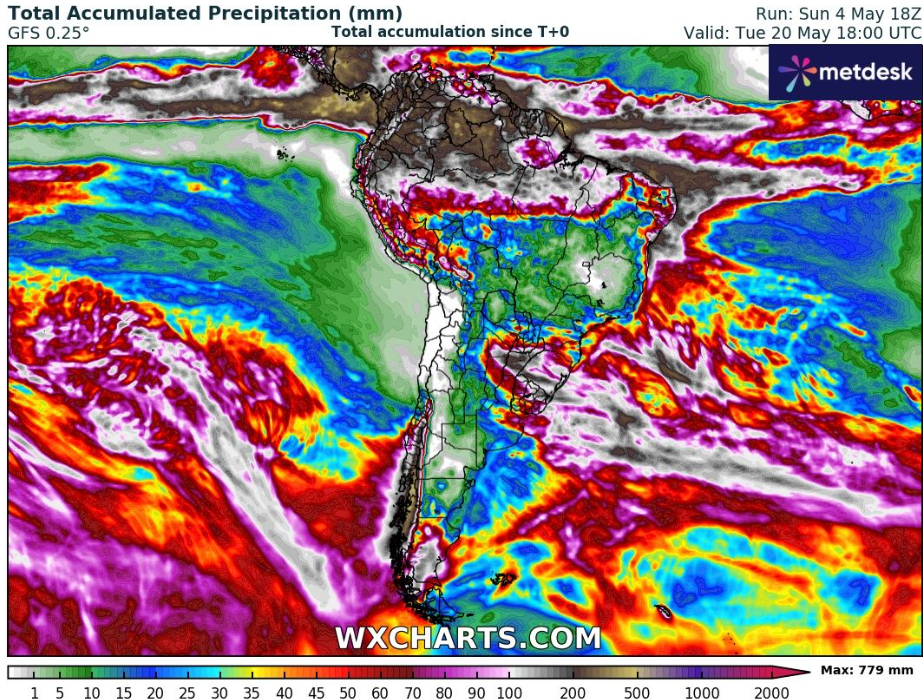
Accumulated precipitation in South America until 20. May 2025. Source: https://www.wxcharts.com/
Africa
We can again return into persisting heatwaves in southern parts of Africa, in Alexander Baai in South Africa with hot May +35,7°C. Heatwaves +30/+35°C in South African highlands are furthermore expected, which is mid-summer-like temperatures. As we mentioned in the last articles /https://mkweather.com/weather-report-04-05-2025/, https://mkweather.com/weather-report-for-may-3rd-2025-unseasonal-heat-in-central-continental-europe-30c-in-austria-and-hungary-high-temps-along-mid-atlantic-us-seaboard-31c-in-virginia-and-maryland-midd/, https://mkweather.com/weather-report-for-1-may-2025-continental-europe-after-tropical-heatwave-frosts-and-snow-in-basins-finland-102c-the-netherlands-295c-germany-288c-severe-storms-hit-easter//, temperature records and heatwaves hit Madagascar, Mozambique or islands in Indian Ocean, and other states, too.
In the last days, the historically powerful Khamaseeni winds returned to Egypt, with blinding sandstorms. The low pressure system arrives in spring, carrying dust and sand from the Sahara Desert in North Africa, every year. Schools and many services were in the last week closed in Egypt.
Rainfall forecasts up to 20. May 2025 are promising possible floods in Liberia region, Cameroon, Gabon, easternmost Congo, southern Uganda, NW and E Tanzania, Rwanda and Burundi.
Source: https://x.com/extremetemps/status/1919111347222045087/photo/1
Accumulated precipitation in Africa until 20. May 2025. Source: https://www.wxcharts.com/
Australia
Tmaxes above +35°C in Australia in late Autumn are in the next days still possible.
Several records of May warmest nights were broken in Australia again. More abnormal warmth coming with near summertime temperatures for any foreseeable future according to Extreme Temperatures Around the World on X.
Minimum temperatures of +17,2°C in Low Rocky Point, Tasmania, means unseasonably warm late-Autumn weather.
In the next tropical days >30°C in Perth, Western Australia, again, is expected.
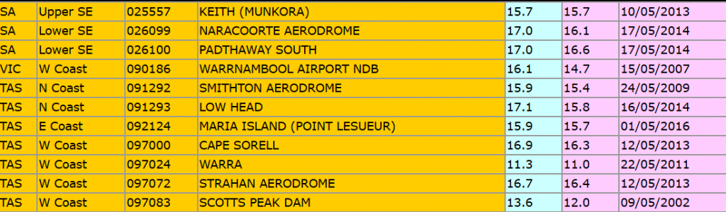
April 2025 in New Zealand brought 30 records of highest monthly Tmaxes and highest Tmins (tables below).
Outlook for Australia is very dry, with some coastal rains and storms only.
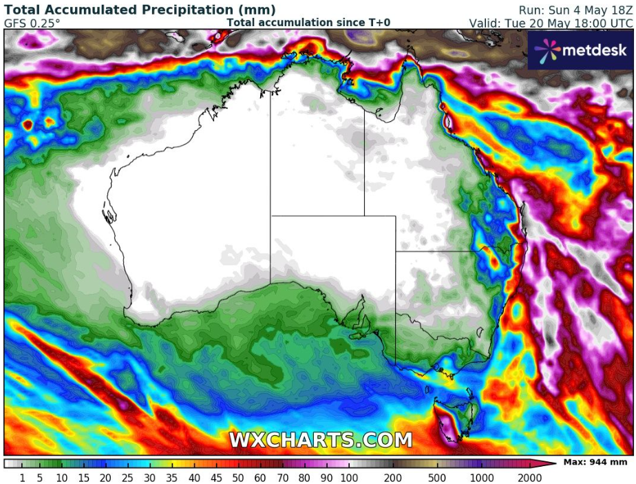
Accumulated precipitation in Australia until 20. May 2025. Source: https://www.wxcharts.com/
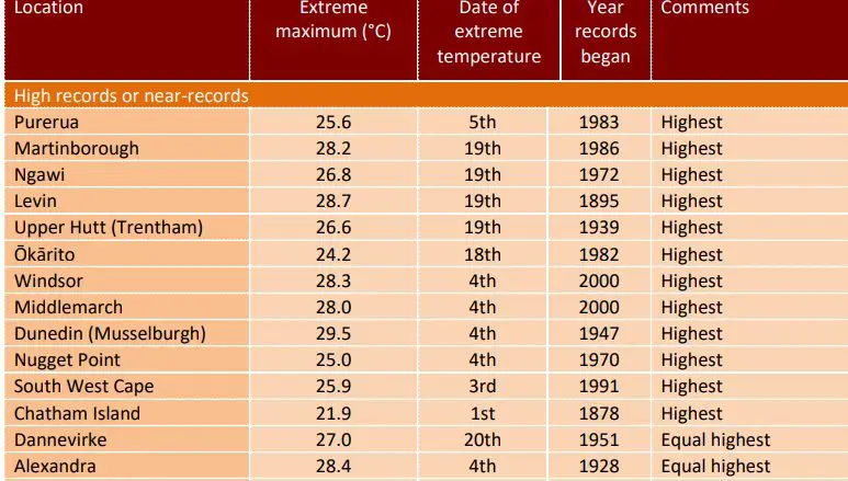
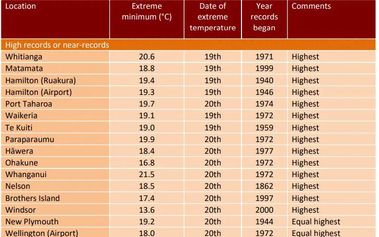
April records in parts of New Zealand. Source: https://x.com/extremetemps/status/1919314085704872229
High Tmin temperatures in Australia. Source: https://x.com/extremetemps/status/1919272656752230751/photo/1
The Arctic and Antarctica
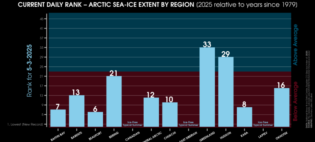
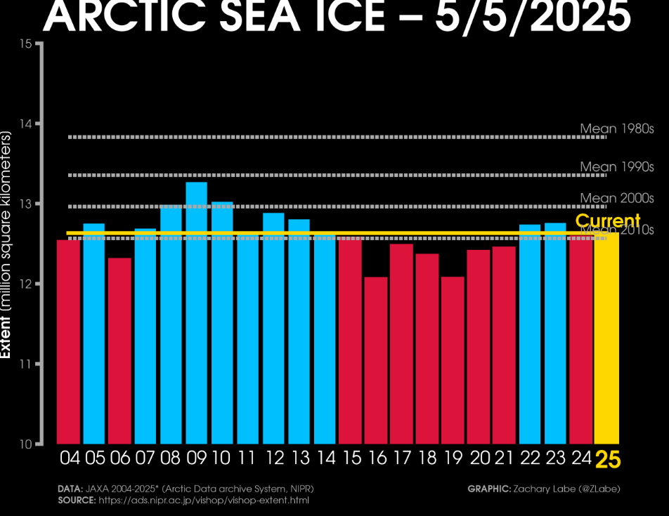
From the Arctic region we are today choosing anomalously cold Arctic, with above average Hudson Bay and Greenlandic sector of the Arctic Sea Ice extent anomaly.
Anomaly is so strong, that these days, we are at levels of the 3 “coldest” years for last 10 years, while soon we should be the “coldest” (it means, with a stronger above-average anomaly) since 2015.
At the end, a study about Antarctic ice sheet cooling trends.
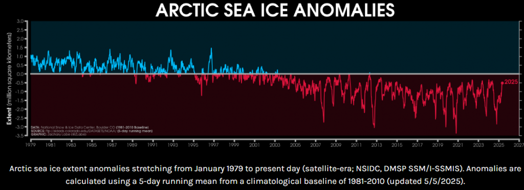
Source: https://zacklabe.com/arctic-sea-ice-extentconcentration/
Source: https://zacklabe.com/arctic-sea-ice-extentconcentration/
Source: https://zacklabe.com/arctic-sea-ice-extentconcentration/
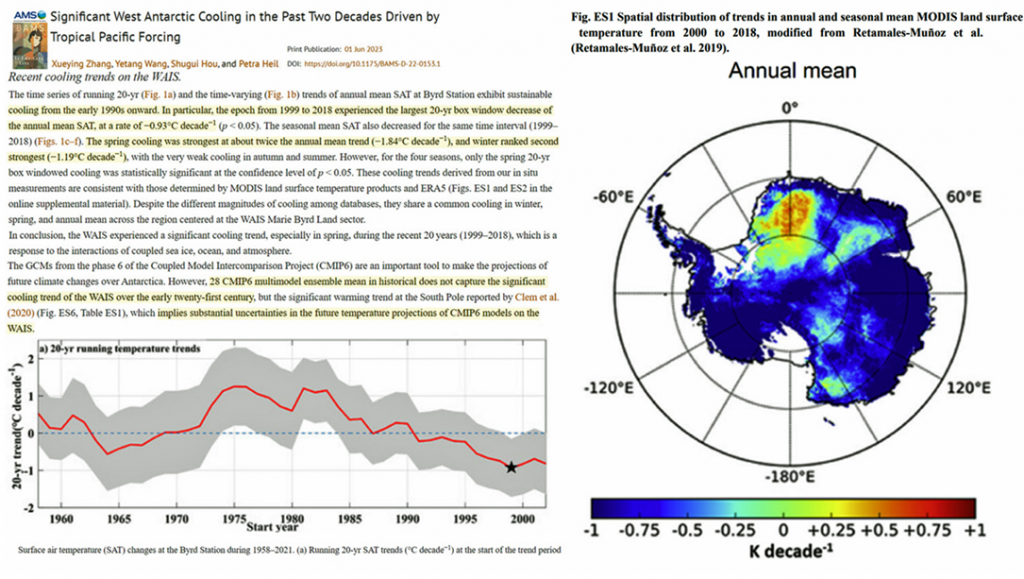
Source: Zhang et al. 2023


1 thought on “Weather report for 5. May 2025: Coldwave in Europe will last long 2 weeks, bringing snow and frosts (Sweden -10,5°C, Finland -10,4°C, the UK -2,9°C, Poland -1,7°C, the Netherlands -1,4°C, Denmark -1,3°C, Baltic countries -1,3°C, Germany -0,4°C), frosts below -5°C in basins and valleys possible on snowfall up to 5 cm below 1000 MASL, severe storms in Southern Europe expected, France and Italy already with 5 cm hail and floods / Canada +32,5°C, the US from cold and stormy to hot and dry pattern next weeks / Sandstorm in Saudi Arabia and heatwaves in the Middle East and Central Asia, flooded Dimona, Israel, hail in Guanzhou, China / Hewataves in Bolivia, South Africa and Australia / Anomalously cold Arctic”