OVERVIEW Winter 2025/26 across North America is poised to deliver dynamic and evolving weather conditions, shaped by a complex interplay of global and regional climate signals. From the fading influence of a strong El Niño to the anticipated behavior of the polar vortex and stratospheric processes, this season may challenge traditional expectations and produce a stark contrast between the first and second halves of winter.
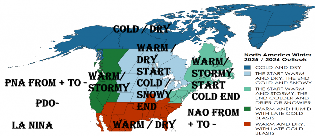
The overall setup suggests a mild and wet start to the season, especially in the southern U.S., the East Coast, and parts of western Canada. However, significant pattern changes are possible in mid-to-late winter, with a mounting risk of Arctic air outbreaks, late-season snowstorms, and polar vortex disruptions. Key teleconnections such as the North Atlantic Oscillation (NAO), Arctic Oscillation (AO), Pacific-North American pattern (PNA), and Quasi-Biennial Oscillation (QBO) will influence storm tracks, temperature patterns, and regional precipitation.
Warm sea surface temperatures (SSTs) in the Gulf of Mexico, the subtropical Atlantic, and parts of the North Pacific will likely fuel moisture-laden systems and atmospheric rivers, while colder waters in the central Pacific and potential La Niña tendencies by spring may begin to shape the tail-end of winter.
This forecast provides a region-by-region breakdown for North America, highlighting expected seasonal trends in temperature, precipitation, snow risks, and extreme weather events, organized by key climatological zones.
REGIONAL OUTLOOKS
1. WESTERN NORTH AMERICA
(British Columbia, Alberta, Yukon, U.S. Pacific Northwest, California, Great Basin)
Temperature: Near-normal to slightly below average in inland Canada and the northern Rockies. California and coastal areas may be above normal in December. Cooling possible in late January–February.
Precipitation: Near to above-normal in British Columbia, Washington, and Oregon due to enhanced Pacific jet activity. Wetter-than-average conditions expected in California early in the season.
Snow & Extremes: Enhanced snowpack for the Sierra Nevada and Cascades. Risk of flooding rains in California from atmospheric rivers in December. Potential for cold outbreaks and blizzards in late winter, especially interior Pacific Northwest.
2. SOUTHWEST & SOUTH-CENTRAL U.S.
(Arizona, New Mexico, Texas, Oklahoma, Southern Rockies)
Temperature: Warmer than normal, particularly in December and January. February may see colder air intrusions if Arctic air penetrates southward.
Precipitation: Near to slightly below average across the southern tier, though localized wetter periods possible with subtropical jet enhancement.
Snow & Extremes: Limited lowland snow except during cold intrusions in February. Northern NM and Colorado Rockies will see near-normal snowpack. Winter storm potential rises in February.
3. CENTRAL & NORTHERN PLAINS
(Montana, Dakotas, Nebraska, Kansas, Manitoba, Saskatchewan)
Temperature: Above average early winter; below average more likely in February due to potential SSW effects.
Precipitation: Near-normal with occasional snowstorms. Potential for dry December followed by active storm track in January–February.
Snow & Extremes: Arctic air outbreaks could produce major snow events and blizzards in late winter. High risk of polar vortex-induced extremes in February.
4. MIDWEST & GREAT LAKES
(Minnesota, Wisconsin, Michigan, Ohio Valley, Ontario)
Temperature: December and January milder than normal; February colder, especially around Great Lakes.
Precipitation: Above-normal snowfall likely from lake effect events in January and February. Ohio Valley may trend wetter than average.
Snow & Extremes: Risk of significant snow and freezing rain events increases after January. Watch for wind chills and lake-effect snow bursts in February.
5. NORTHEASTERN U.S. & EASTERN CANADA
(New England, Quebec, Maritime Provinces)
Temperature: Near to slightly above average December–January, then trend toward colder in February.
Precipitation: Near to above-normal precipitation. Snowfall near average, except heavier snow in favored coastal and interior zones.
Snow & Extremes: Nor’easters are possible with enhanced baroclinicity in January–February. Icy mix storms likely.
6. SOUTHEASTERN U.S.
(Carolinas, Georgia, Florida, Gulf States)
Temperature: Above normal through most of the season, especially Florida. Some cold snaps in February possible if pattern shifts.
Precipitation: Below normal in Florida and Gulf Coast; potential for wetter periods in Southeast Appalachians.
Snow & Extremes: Low risk of snow except northern Carolinas and Tennessee. Watch for ice storms in February transition.
7. NORTHERN & ARCTIC CANADA
(Nunavut, Northwest Territories, northern Quebec/Labrador)
Temperature: Near to slightly below normal; potential for prolonged Arctic highs in February.
Precipitation: Drier than normal, except coastal Labrador. Cold and dry Arctic regime likely.
Snow & Extremes: Limited new snow accumulation. Extreme wind chills and cold outbreaks frequent from January onward.
CLIMATE DRIVERS & TELECONNECTIONS SUMMARY
- ENSO: El Niño weakening → neutral. Winter begins warm, pattern shift possible late season.
- NAO/AO: Likely positive early = milder east; potential reversal in February = eastern U.S./Canada cold.
- SSW: Moderate risk; January SSW could lead to February polar outbreaks.
- PDO: Negative phase; may support western troughing in late winter.
- PNA: Weakly positive early, may dip negative by February = supports eastward cold shifts.
- QBO: Westerly phase; strong polar vortex early.
- SSTs: Gulf warmth favors storm intensification; Alaska warmth = jet amplification.
- MJO: Active pulses in phases 6–7 may boost storms in SE U.S. & East Coast.
PROGRESSION MONTH-BY-MONTH (Summary)
- December: Warm start to winter across U.S. & southern Canada. Wet West Coast; dry Southeast.
- January: Storm tracks increase in Central/Eastern U.S.; Rockies snowier. Polar vortex remains intact.
- February: Pattern reversal likely. Arctic air into Plains, Midwest, East Coast. Increased snowfall potential. Coldest anomalies likely.
FINAL NOTES
Winter 2025/26 may be front-loaded with mild and wet conditions in the southern and eastern U.S., but with growing potential for significant cold air outbreaks, snowstorms, and wintry extremes in February due to weakening of the polar vortex. Western snowpack outlook is promising. Storm risks increase late season for the Northeast, Great Lakes, and Plains.


