Storm Alert for Europe (!) Large Hail, Floods, Gusty Winds, and Tornadoes hit these Regions! Switzerland, Germany and Czechia under the Siege!
Between June 2 and 4, 2025, Europe experienced a series of severe convective storms, as detailed in the European Storm Forecast Experiment (ESTOFEX) reports. These storms were characterized by heavy rainfall, large hail, and damaging wind gusts, affecting a broad swath of the continent.
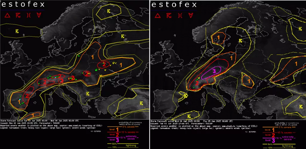
June 2–3, 2025: Elevated Storm Activity Across Central Europe
On June 2, ESTOFEX issued Level 1 and Level 2 warnings for a belt stretching from northern Spain through France, Germany, and into Belarus. The primary threats included excessive convective precipitation, large hail, and severe convective wind gusts, particularly in the northwestern sectors.
The synoptic situation featured a trough over western Europe, promoting instability and convective development. Enhanced low-level moisture and moderate to high Convective Available Potential Energy (CAPE) values contributed to the formation of organized thunderstorms. These storms were capable of producing large hailstones, heavy rainfall leading to localized flooding, and strong wind gusts.
June 3–4, 2025: Continued Severe Weather Threats
The storm activity persisted into June 3, with ESTOFEX maintaining Level 1 and Level 2 warnings for similar regions. The forecasts highlighted the potential for long-tracked supercells and bowing segments, which could result in severe wind gusts, large hail, and isolated tornadoes.
The atmospheric conditions remained conducive to severe convection, with sufficient shear and instability to support organized storm structures. Heavy rainfall continued to pose a risk for flash flooding in affected areas.
June 4-5, 2025: Switzerland, Germany and Czechia under the Siege!
On June 4, 2025, Europe experienced a significant severe weather outbreak, with multiple regions under elevated risk levels as forecasted by the European Storm Forecast Experiment (ESTOFEX). The most intense activity was centered over parts of Switzerland, southern Germany, and the Czech Republic, where a Level 3 warning—the highest on the ESTOFEX scale—was issued.
A deep cyclonic vortex, with an unseasonably low central pressure of around 970 hPa, was positioned over the Faroe Islands. This system influenced much of northwestern Europe, while a quasi-stationary warm-core ridge persisted over southeastern Europe. The interaction between these systems created a highly unstable atmosphere conducive to severe convective development.
Level 3 Warning: Extreme Risk
A Level 3 warning, the highest issued by ESTOFEX, was in effect for parts of northeastern Switzerland, southern Germany, and the Czech Republic. This area faced widespread severe to damaging wind gusts and large hail, with some events reaching extremely severe levels. The synoptic situation featured a deep cyclonic vortex over the Faroe Islands, interacting with a warm-core ridge over southeastern Europe, creating a highly unstable atmosphere conducive to severe convective development.
Level 2 Warning: Significant Risk
Surrounding the Level 3 area, a Level 2 warning encompassed regions with similar hazards but somewhat lower probabilities.
- Switzerland: Beyond the northeastern region, other areas faced risks of severe thunderstorms with large hail and damaging winds.
- Germany: Central and southern parts were under threat from organized convective systems, leading to hail and damaging wind events.
- Czech Republic: Apart from the northeastern region, other areas faced risks of severe thunderstorms.
- France: Southeastern regions experienced severe thunderstorms with reports of large hail and heavy rainfall.
- Italy: Northwestern regions, particularly near the Alps, were at risk due to the interaction of moist air masses and orographic lifting.
Additionally, southeastern Switzerland was under a rainfall-driven Level 2 warning due to the potential for training multicells and supercells, leading to significant precipitation.
Level 1 Warning: Marginal Risk
A broader Level 1 warning was issued for areas with lower probabilities of severe weather but still facing potential hazards. This included:
- Romania: Central regions were mainly at risk for large hail and a few severe gusts.
- Sweden: Central parts faced risks of isolated tornado events and gusts/hail due to scattered thunderstorms.
- Ukraine and Russia: Southeastern Ukraine into Russia was under threat for hail, strong to severe gusts, heavy rain, and a possible isolated tornado event towards Russia.
These areas were influenced by the interaction of upper troughs and moist, unstable air masses, leading to the development of severe convective storms.
🌀 Severe Weather Risk Levels by Country (4–5 June 2025)
| Risk Level | Country | Threats |
|---|---|---|
| Level 3 | Switzerland (NE) | Very large hail, extreme wind gusts, heavy rain, strong tornadoes possible |
| Germany (South) | Widespread damaging wind gusts, large hail, tornado risk | |
| Czech Republic (West/North) | Severe thunderstorms, large hail, wind damage | |
| Level 2 | Switzerland (rest) | Severe hail, flash flooding, tornado risk |
| Germany (central areas) | Organized convective storms, large hail, wind | |
| Czech Republic (central/south) | Hail, heavy rain, isolated tornadoes | |
| France (SE, near Alps) | Thunderstorms with large hail, heavy rain | |
| Italy (NW, Po Valley, Alps) | Large hail, wind gusts, orographic storms | |
| Austria (West) | Supercells, hail, wind gusts | |
| Level 1 | Romania (central/west) | Local hail, gusty storms |
| Sweden (central) | Isolated tornadoes, strong winds | |
| Ukraine (SE) | Hail, wind, rain, isolated tornado | |
| Russia (border regions) | Hail, storm gusts, isolated tornado | |
| Poland (southwest) | Scattered hailstorms | |
| Hungary (west) | Local severe storms, rain | |
| Slovakia (west) | Marginal risk of hail, wind |
✅ Notes:
Level 1 represents isolated severe weather events, still potentially dangerous.
Level 3 is the highest risk: widespread, potentially life-threatening events.
Level 2 indicates scattered severe storms with substantial impact.


