Heatwave in Western Australia, while Eastern Australia and New Zealand Expect Frosts and Snow
Western Australia Breaks June Records with Unprecedented Nighttime Heat and Rainfall
In early June 2025, Western Australia is experiencing a remarkable heatwave, setting new records for the highest minimum temperatures during the month. Among the notable record breakers are Norseman Aero and Rocky Gully, which recorded their hottest June nights ever observed.
Norseman Aero registered a minimum temperature of 15.8°C, while Rocky Gully reached 13.4°C — both marking unprecedented warmth during nighttime hours in June. These unusually high minimum temperatures highlight a broader pattern of rising nighttime heat, which is particularly challenging as it offers little respite from the daytime heat, increasing stress on human health and ecosystems.
Adding to its unusual weather, Norseman Aero also set a June record for the highest 24-hour precipitation, receiving 31.2 millimeters of rainfall in a single day. This combination of intense heat and significant rainfall is an unusual and striking weather event, underscoring the extreme variability and shifting patterns seen in the region’s climate.
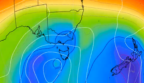
Cold Fronts to Bring Snow and Chill to Southeastern Australia and New Zealand
In the coming week, southeastern Australia is bracing for a significant weather pattern marked by a series of cold fronts sweeping across the region. This cold wave is expected to bring consistent snowfall to the Australian Alps, just as the winter ski season begins to ramp up, offering promising conditions for winter sports enthusiasts.
The forecast calls for a bleak midweek ahead, particularly for southern Victoria (VIC) and eastern New South Wales (NSW), where temperatures will plunge, leading to cold nights and a noticeable chill in the air. The arrival of these cold fronts will not only bring snowfall to the higher elevations but could also result in sharp temperature drops even at lower levels, making for a distinctly wintry week.
Across the Tasman Sea, New Zealand may also see snowfall reaching sea level, an event that is relatively rare and points to the strength and cold nature of the approaching weather systems. This could impact transport and daily life, especially in lower-lying areas that are not accustomed to snow.
The outlook for Australia’s ski fields is particularly optimistic, with models agreeing on the likelihood of substantial snow over the upcoming long weekend. This spells good news for winter tourism and recreational activities, as fresh snow cover boosts the quality of skiing and snowboarding conditions.
The Global Forecast System (GFS) model supports this forecast, and there is strong consensus among other meteorological models, reinforcing confidence in the predicted cold and snowy weather pattern.
Overall, residents and visitors in southeastern Australia and New Zealand should prepare for colder conditions and possible snow.
Illustration map: https://x.com/andrewmiskelly/status/1929412620559208558


