After Hurricane Barbara, Hurricane Cosme? Not so Often to Appear Trio Tropical Storms in Eastern Pacific First
🌊 Tropical Storm Cosme Poised for Rapid Intensification
Current Status and Forecast
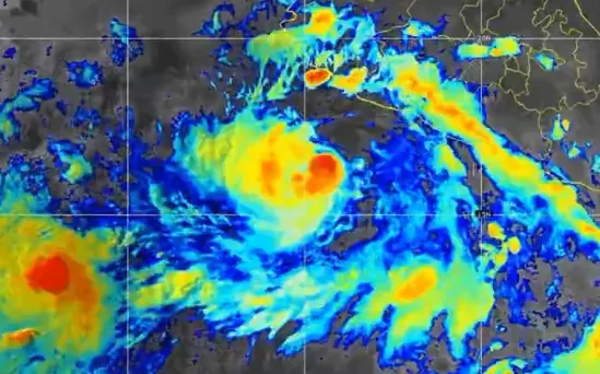
- Location & Intensity: As of June 9, 2025, Cosme is situated roughly 630 miles (1,015 km) south-southwest of Baja California’s tip, moving west-northwest at about 9 mph (15 km/h).
- Winds & Pressure: Cosme has sustained winds near 50 mph (85 km/h) and a central pressure around 999 mb, making it a moderate tropical storm.
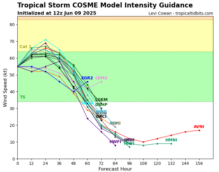
- Intensity Outlook: The National Hurricane Center (NHC) and observational models (ASCAT, Dvorak) indicate continuing intensification: Cosme is forecast to reach near-hurricane strength (70–75 mph) by late Monday or Monday night, June 9–10.
🌪️ Life Cycle & Confidence
- Formation: Cosme is the third named storm of the 2025 Eastern Pacific season, forming swiftly following Tropical Storm Alvin and Hurricane/Storm Barbara.
- Forecast Track: Under influence of upper-level ridging, Cosme is expected to curve northeast after Monday, accelerating as it turns.
- Duration & Decline: The system is likely to peak Monday–Tuesday, before weakening rapidly into a remnant low or dissipating by Wednesday, becoming post-tropical by midweek.
⚠️ Impacts: Low, but Not Zero
- No Coastal Threat: Cosme remains well offshore, with no watches or warnings issued.
- Marine Concerns: Mariners should monitor shoreline swells, and marine interests must stay alert due to possible tropical-force gusts in open waters .
- Potential for Hurricane Force: If Cosme reaches hurricane status, islands southwest of Baja and offshore platforms could experience storm-force winds and heavy rain within the forecast window.
🧭 Strategic Context
- Seasonal Notes: Cosme’s intensification marks an active early season in the Eastern Pacific—three named storms before mid-June is well ahead of climatological norms.
- Atmospheric Factors: Favorable conditions—low vertical wind shear, warm sea-surface temperatures—are fueling Cosme’s development.
- Uncertainty & Interaction: Interaction with Storm Barbara to the east may influence Cosme’s track and structure, though current consensus tracks maintain a northwest then northeast trajectory.
📝 Final Summary
| Feature | Details |
|---|---|
| Current Intensity | Tropical storm → 50 mph winds; 999 mb pressure |
| Forecast Peak | Near-hurricane strength Monday night into Tuesday morning |
| Track & Timing | Moving WNW → northeast midweek |
| Land Threat | No immediate coastal threat; marine impact possible |
Tropical Storm Cosme is expected to strengthen into a minimal hurricane, reaching peak intensity early this week before turning northeast and weakening. While unlikely to impact land directly, Cosme highlights the rapid tropical development in the Eastern Pacific and reinforces this season’s above-average activity.


Source: https://www.tropicaltidbits.com/storminfo/#03E
Illustration map: https://twitter.com/i/status/1931890670370791786


