Tropical Depression 92W Invest hit Philippines and aims towards China, South Korea and Japan
Overview
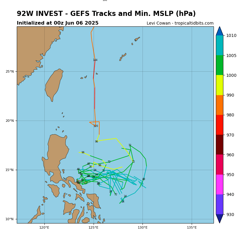
As of June 9, 2025 (06:00 UTC), Invest 92W, a developing tropical disturbance in the western Pacific Ocean, is drawing attention from meteorologists across Asia. Currently located near 16.5°N and 116.6°E, the system lies over the open ocean east of the Philippines and is showing early signs of cyclonic development.
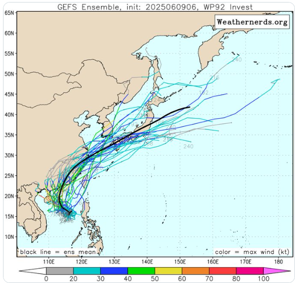
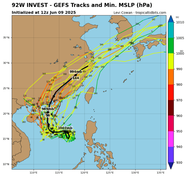
With maximum sustained winds of 15 knots and a central pressure of 1002 mb, it remains a weak system for now — but forecast models suggest a strengthening trend in the coming days, with a likely northwestward to northward trajectory. This path could bring impacts to China, South Korea, and Japan later this week or early next week.
🌏 Tropical Disturbance Overview: Invest 92W
🕒 Time and Date
- Observation Time: 06:00 UTC, June 9, 2025
📍 Location
- Coordinates: 16.5° North, 116.6° East
- This places Invest 92W over the western Pacific Ocean, east of the Philippines, and southwest of Taiwan. It is within a region known for tropical cyclone development, particularly in early summer.
🌬️ Wind Characteristics
- Maximum Sustained Winds: 15 knots (≈ 28 km/h or 17 mph)
- Wind Gusts: Not available
- These wind speeds are typical for a weak tropical disturbance. At this stage, Invest 92W has not yet developed into a tropical depression or storm.
🌡️ Pressure Details
- Minimum Central Pressure: 1002 millibars (mb)
- This is slightly lower than the surrounding environmental pressure, indicating some weak surface low pressure organization.
- Environmental Pressure: Not specified
🌀 Structure
- Radius of Circulation: Not provided
- Radius of Maximum Wind: Not provided
- These missing details suggest that the system’s inner core is not well-defined, which is common at the early “Invest” stage of development.
🔍 What is an “Invest”?
An “Invest” (short for “investigation”) is a designation given by meteorological agencies (like the Joint Typhoon Warning Center or JTWC) to an area of disturbed weather that may develop into a tropical cyclone. It is a way to track, analyze, and model the system using satellite, radar, and numerical simulations.
📈 Potential Development
As of this observation:
- Invest 92W is being monitored for signs of development.
- If environmental conditions become more favorable (e.g., warm sea surface temperatures, low vertical wind shear), it could intensify into a tropical depression or tropical storm in the coming days.
- Forecasters will continue to monitor for:
- Convective organization (clusters of thunderstorms)
- Surface circulation tightening
- Falling central pressure
- Increased wind speeds
🌧️ Expected Impacts in the Philippines
Although Invest 92W is still disorganized, its outer rainbands and moisture feed are forecast to bring unsettled weather across northern and central Luzon, and possibly parts of Visayas, during the next 24–48 hours.
Key Impacts:
- Scattered heavy showers and localized thunderstorms
- Possible flash flooding in low-lying areas
- Gusty winds in convective cells
- Rough seas along eastern coastal waters
No official tropical cyclone warning has been issued yet by PAGASA, the Philippine weather agency, but invest status means the system is under active observation for further development.
🌀 Short Stay, But Important Effects
While Invest 92W is not expected to make direct landfall, its broad circulation and moisture could affect the Philippines briefly between June 9–11, especially in the form of enhanced southwest monsoon flow (“habagat”) if it deepens near Luzon.
After that, the system is projected to:
- Strengthen into a tropical depression or tropical storm
- Curve northwest to north, placing China, South Korea, and southern Japan in the potential path later in the week
Forecast Track & Impact Regions
🇨🇳 China (Southern and Eastern Coasts)
- Guangdong, Fujian, and Zhejiang provinces are in the potential path.
- Based on early model guidance, if the system curves northwest, it could approach China’s southeastern coast by the weekend or early next week.
- Main threats: Heavy rain, flash flooding, and gusty winds, especially if the system strengthens into a tropical storm or more.
🇰🇷 South Korea
- If 92W moves more northward, it may influence South Korea, especially the southern coast and Jeju Island.
- Timing: Likely early to mid next week.
- Impacts could include moderate rainfall and coastal winds, depending on the system’s intensity.
🇯🇵 Japan (Kyushu, Shikoku, Southern Honshu)
- Some forecast models show a northeastern turn, which would steer the system toward southern Japan.
- The Japanese Meteorological Agency (JMA) is monitoring for early signs of organization.
- Potential impacts: Heavy rainfall, flooding risks, and local wind damage.
Development Outlook
- Short-Term (next 48 hours): Gradual organization; may reach tropical depression status.
- Medium-Term (3–5 days): High potential for tropical storm formation.
- Long-Term (5–7 days): Potential landfall or coastal approach near East Asia (China, Korea, or Japan), depending on steering patterns from the subtropical ridge and monsoon trough.
Uncertainty and Monitoring
It is important to note that:
- The exact path and intensity remain uncertain.
- Small changes in steering winds or the system’s core structure could significantly alter its trajectory.
- All countries in the system’s possible path are advised to monitor official updates from JTWC, JMA, KMA, and China Meteorological Administration (CMA).
Conclusion
Invest 92W is currently a weak but closely watched tropical disturbance with the potential to strengthen and impact East Asia. While not yet a named storm, its development could threaten millions of people across China, South Korea, and Japan with flooding rains and coastal hazards. Preparation and continued monitoring are crucial over the coming days.
Source: https://www.tropicaltidbits.com/storminfo/#92W

Source: https://x.com/mscuyugan/status/1932084037344264328/photo/1


