Autumn 2025 Forecast for Asia: Monsoon Shifts, Typhoon Threats, and Siberian Cold + 20 MAIN TELECONNECTIONS
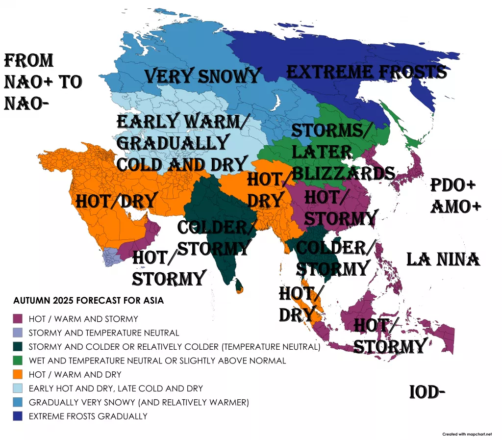
As the calendar turns to autumn 2025, Asia faces a season defined by contrasts and climate signals that stretch from the tropical Indian Ocean to the frozen Arctic Circle. The coming months will bring late-season monsoon rains, powerful typhoons, and surges of Siberian cold, all influenced by a complex web of teleconnections.
The Big Climate Drivers
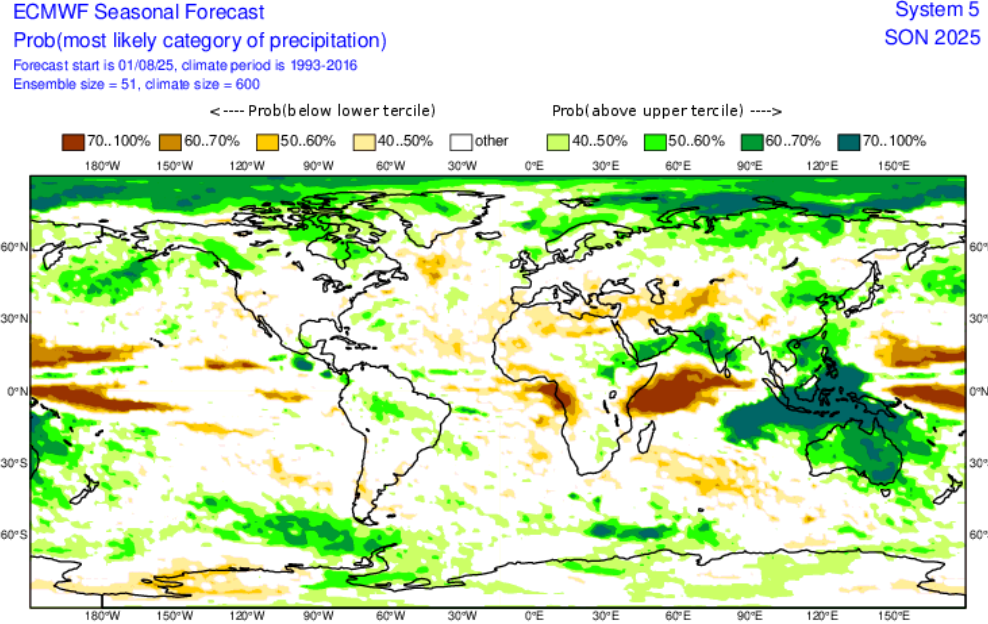
The most important player is the developing La Niña in the tropical Pacific. This pattern will reinforce wet conditions in Southeast Asia while encouraging dryness across southern India as the monsoon withdraws. At the same time, a negative Indian Ocean Dipole (IOD) is expected to enhance rainfall in Indonesia and Malaysia, even as Pakistan and northern India remain vulnerable to flooding.
Further north, the Arctic Oscillation (AO) and North Atlantic Oscillation (NAO) will control the timing of cold surges from Siberia into East Asia. Early in autumn, a positive AO/NAO combination should keep much of Asia unusually warm, but as October shifts into November, more frequent negative phases could unleash bitter early-season cold into Mongolia, northern China, and Korea.
Meanwhile, the Madden-Julian Oscillation (MJO) will pulse across the equatorial belt, energizing typhoons in the western Pacific. The Pacific Decadal Oscillation (PDO) remains slightly positive, supporting warmer seas near Japan, which may strengthen these storms. With the Atlantic Multidecadal Oscillation (AMO) still in its warm phase, the large-scale background supports an active West Pacific tropical season well into October.
Regional Patterns
South Asia
The Indian subcontinent will experience a delayed and uneven monsoon withdrawal. While southern India and Sri Lanka turn drier than normal, Pakistan and northern India remain at risk of flooding rains through September. By October and November, much of the region will slip into drought-like conditions, a dangerous shift following months of monsoon flooding.
Southeast Asia
This region will be the wettest in Asia this autumn. The La Niña–IOD pairing will fuel persistent rainfall over Indonesia, Malaysia, and the Philippines. Typhoon risks will be highest in Vietnam, Taiwan, and the Philippines, particularly in September and early October, when tropical activity peaks.
East Asia
China, Korea, and Japan will face a two-part season. September and early October will remain warmer than normal, with frequent typhoon threats along coastal China, Taiwan, and southern Japan. But by late October and November, cold Siberian air masses will begin spilling south, setting the stage for early snow across northeast China, Mongolia, and Hokkaido.
Central Asia
From Kazakhstan to Uzbekistan, early autumn will be marked by heat and drought, tied to a lingering positive NAO. But by November, massive Siberian high-pressure systems will build, pushing polar air into the steppes. This transition may lead to record early freezes in Kazakhstan and Mongolia.
Siberia and the Russian Far East
The extremes of 2025 continue. September warmth in the Arctic will be extraordinary, with temperatures up to 20–25°C at 70°N, shattering all records for this late in the year. Yet by October, the pendulum will swing: snow cover will expand rapidly, reinforcing a cold Siberian dome that spills southward into East Asia.
The Middle East
For Iran, Afghanistan, and the Arabian Peninsula, the story is warmth and dryness. With no major rainfall drivers in play, this region will endure prolonged heat and water stress into November.
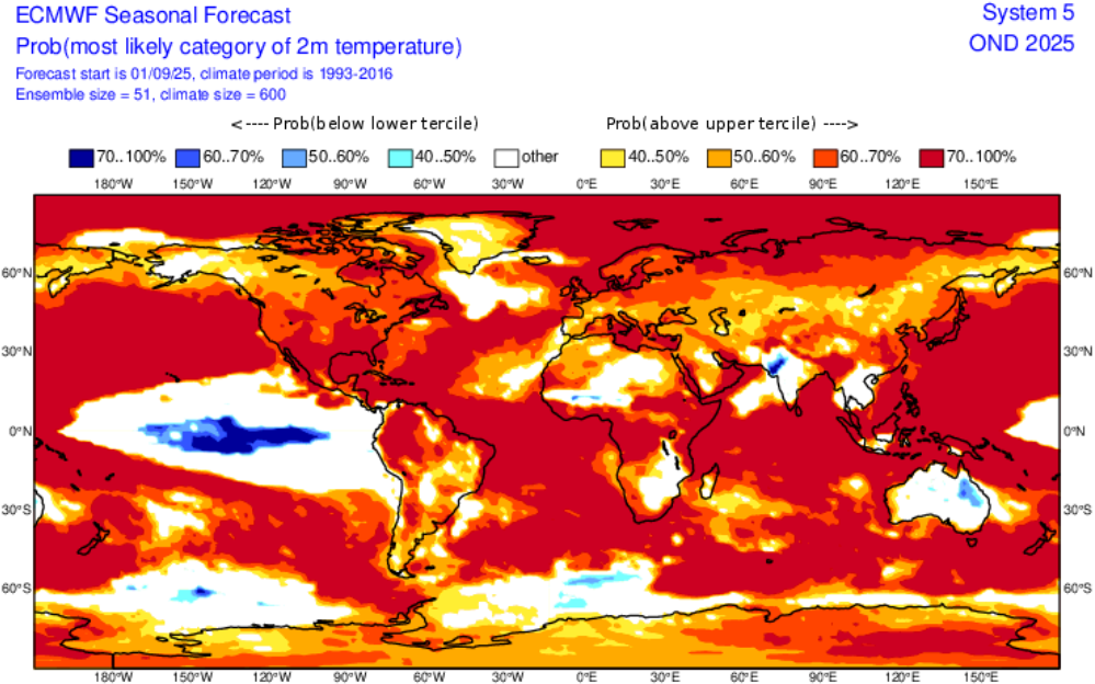
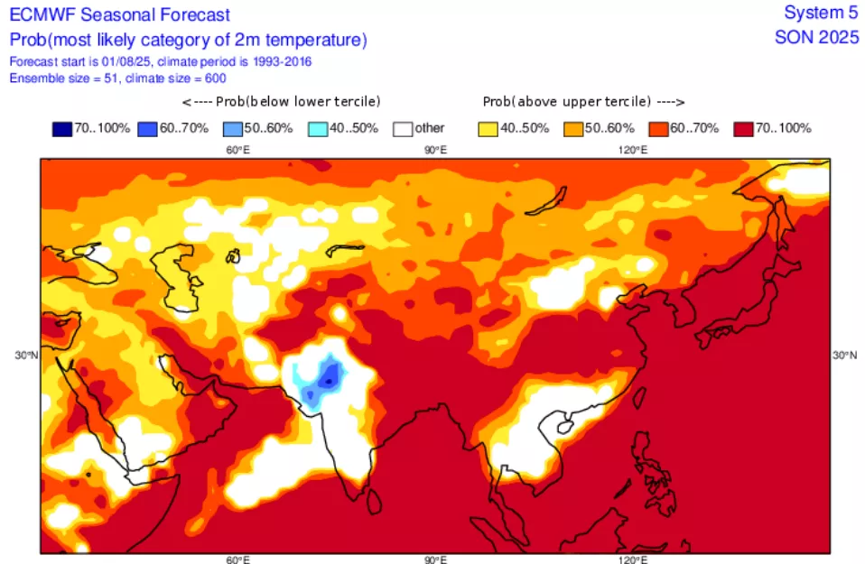
Temperature Outlook: Warm vs. Cold Zones
- Warm anomalies: Southern Asia (India, Pakistan, Middle East), East Asia (China, Korea, Japan in September–October).
- Cold anomalies: Northern Asia, especially Siberia, Mongolia, northern China by late October–November.
- Mixed zones: Central Asia, starting hot and dry, then flipping to cold by late autumn.
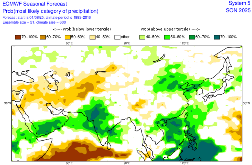
Precipitation Outlook: Wet vs. Dry Zones
- Wet zones: Southeast Asia (Indonesia, Malaysia, Philippines, Vietnam, southern China, Taiwan).
- Dry zones: Southern India, Sri Lanka, Arabian Peninsula, Central Asia after monsoon withdrawal.
- Storm zones: East Asia, where typhoons bring heavy rainfall in September–October, followed by drier, colder conditions in late November.
The Role of Teleconnections in Detail
- La Niña: Wet tropics, dry subtropics, enhanced late typhoons.
- Negative IOD: More rainfall in Southeast Asia, reduced rainfall in India.
- MJO: Phases triggering clusters of typhoons and tropical rains.
- AO/NAO: Dictating the strength and timing of Siberian cold outbreaks.
- PDO & AMO: Warmer seas → more intense typhoons.
- QBO: Setting up polar vortex instability for winter.
- Eurasian Snow Cover Feedback: Reinforcing cold high-pressure domes by November.
Hazards and Extreme Events to Watch
- Typhoon landfalls in Taiwan, Philippines, southern Japan.
- Flooding rains in Pakistan, Bangladesh, and Indonesia.
- Dust storms and droughts in Iran and Afghanistan.
- Record Arctic warmth in early September in Siberia, followed by sudden freezes in November.
Conclusion: A Season of Contrasts
Autumn 2025 will not be a quiet transition for Asia. Instead, the continent will endure floods, typhoons, droughts, heat, and snow—often in rapid succession. From the storm-swept coasts of the Philippines to the windswept plains of Mongolia, and from the humid jungles of Indonesia to the icy expanse of Siberia, this season will be a showcase of climate volatility.
The message is clear: Asia’s Autumn 2025 will be remembered as a season of extremes, with teleconnections aligning to produce both historic warmth and historic cold within the same three months.
20 Main Teleconnections for Autumn 2025 in Asia
Pacific-Indian Ocean Teleconnections
- ENSO (La Niña)
- Effect: Strengthens late monsoon rains in South/Southeast Asia, enhances typhoon activity in the western Pacific, but suppresses rainfall in India’s south and central regions.
- Indian Ocean Dipole (IOD – negative phase)
- Effect: Brings above-normal rains to Indonesia, Malaysia, and Australia, but drier conditions for India’s northwest and the Middle East.
- Pacific Decadal Oscillation (PDO – warm phase pockets)
- Effect: Warmer waters in the North Pacific → stronger typhoon intensities near Japan, Taiwan, and Korea.
- Atlantic Multidecadal Oscillation (AMO – warm)
- Effect: Strengthens overall global storm activity; helps maintain warmth across Eurasia by amplifying teleconnections from the tropics.
- Madden–Julian Oscillation (MJO)
- Effect: Acts as a short-term storm trigger. September–October phases favor clusters of typhoons in the western Pacific.
- Boreal Summer Intraseasonal Oscillation (BSISO)
- Effect: Delays monsoon withdrawal, keeps rainfall in India, Bangladesh, and Myanmar into late September.
- Walker Circulation Shift
- Effect: Enhanced convection over the Maritime Continent → wetter Indonesia, but suppressed rainfall in East Africa and parts of South Asia.
Polar & Arctic Drivers
- Arctic Oscillation (AO)
- Effect: A negative AO in October–November allows early Siberian cold air outbreaks spilling into Mongolia, China, and Korea.
- North Atlantic Oscillation (NAO)
- Effect: Modulates Eurasian jet stream; a negative phase helps Siberian high pressure dominate and push cold air southward.
- Polar Vortex Strength (Stratosphere)
- Effect: Early weakening, supported by Eurasian snow, could lead to strong November cold waves in northern Asia.
- Eurasian Snow Cover Feedback
- Effect: Rapid October snow expansion → stronger Siberian High, locking cold into Mongolia, China, and even reaching Korea/Japan.
- Sea Ice Anomalies in Arctic Seas
- Effect: Record-low ice near Kara/Barents seas enhances heat fluxes, fueling unusual warmth in September, followed by sharp November cooling.
Monsoon & Regional Drivers
- South Asian Monsoon Withdrawal Timing
- Effect: A delayed retreat leads to flooding in Pakistan, Nepal, Bangladesh in September, then sudden dryness in October–November.
- East Asian Jet Stream Variability
- Effect: Controls typhoon tracks; a stronger jet in October steers storms toward Japan/Korea, while a weaker jet allows China/Taiwan landfalls.
- Western Pacific Subtropical High
- Effect: Strengthened ridge during La Niña pushes typhoons westward into Philippines, Vietnam, and southern China.
- Tibetan Plateau Heating & Cooling
- Effect: Warm September delays westerly strengthening; October–November cooling accelerates winter monsoon winds into East Asia.
Solar, Lunar & Stratospheric Influences
- Quasi-Biennial Oscillation (QBO – easterly phase)
- Effect: Weakens polar vortex later in the season → supports early winter cold intrusions in November.
- Solar Cycle Phase (Solar max approaching)
- Effect: Slight enhancement of tropical convection, supporting stronger typhoons and MJO activity.
- Volcanic Aerosol Forcing (post-Hunga Tonga lingering effects)
- Effect: Still altering stratospheric circulation, possibly enhancing wet anomalies in the Maritime Continent.
- Lunar Nodal Cycle (18.6-year tide cycle)
- Effect: Subtle modulation of coastal rainfall and storm surges; can exacerbate flooding in typhoon-prone regions (Philippines, Taiwan).
Summary: What This Means for Asia
- Wet Zones: Southeast Asia (Indonesia, Malaysia, Philippines, Vietnam, Taiwan) due to La Niña + negative IOD + active MJO.
- Dry Zones: Middle East, Central Asia, southern India, Sri Lanka.
- Warmth: September in East Asia, South Asia, Middle East.
- Cold: Siberia, Mongolia, northern China from late October–November, with AO/NAO + snow feedback driving historic cold waves.
- Storms: Above-normal typhoon activity in September–October, with dangerous landfalls possible in Philippines, Taiwan, Japan, Vietnam, and China.
MKWEATHER AUTUMN 2025 FORECAST FOR ASIA
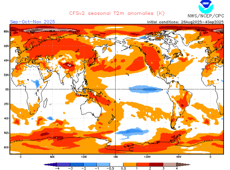
Source: https://www.cpc.ncep.noaa.gov/products/CFSv2/htmls/glbT2me3Mon.html