Autumn 2025 Forecast for North America: A Season of Contrasts and Climate Signals + TOP10 Influencing Teleconnections
🌍 Introduction: A Season of Extremes
As Autumn 2025 approaches, North America is poised to experience a season marked by contrasting weather patterns. While some regions anticipate prolonged warmth and dryness, others prepare for early cold snaps and increased precipitation. These variations are influenced by complex atmospheric and oceanic systems, including the El Niño–Southern Oscillation (ENSO), the North Atlantic Oscillation (NAO), and the Madden-Julian Oscillation (MJO). Understanding these teleconnections is crucial for anticipating the upcoming season’s dynamic weather patterns.
🌡️ Temperature Outlook: Warmth in the West, Coolness in the East
Western United States & Canada
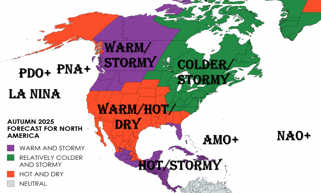
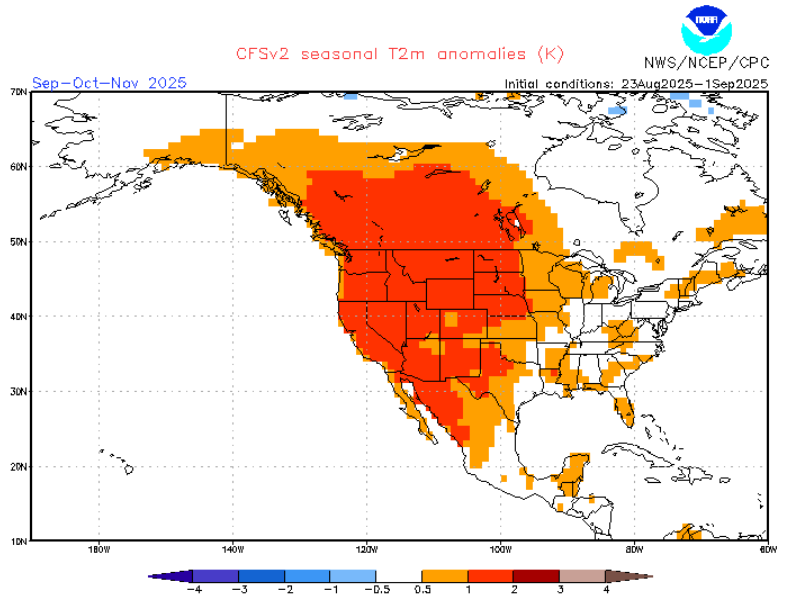
The western regions of North America, including California, Nevada, and the Pacific Northwest, are expected to experience above-average temperatures this autumn. The Climate Prediction Center (CPC) and NOAA seasonal outlooks indicate a higher likelihood of warmer-than-normal conditions. This prolonged warmth could extend the growing season for agriculture, but may also increase the risk of wildfires due to dry conditions.
Eastern United States & Canada
Conversely, the eastern parts of the continent, such as the Midwest, Great Lakes, and Northeast, are likely to experience cooler-than-average temperatures. A significant cold wave is anticipated to bring temperatures 15–25°F below normal, providing relief from recent heatwaves. This early onset of cooler weather could trigger an earlier heating season, impacting energy demand and infrastructure stress across the region.
🌧️ Precipitation Patterns: Wet and Dry Zones
Pacific Northwest & Ohio Valley
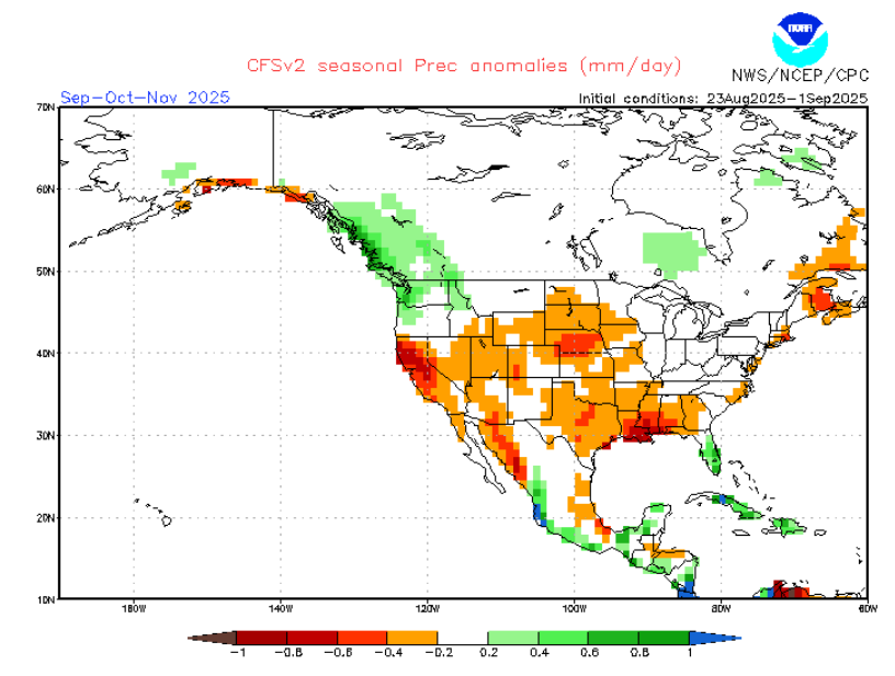
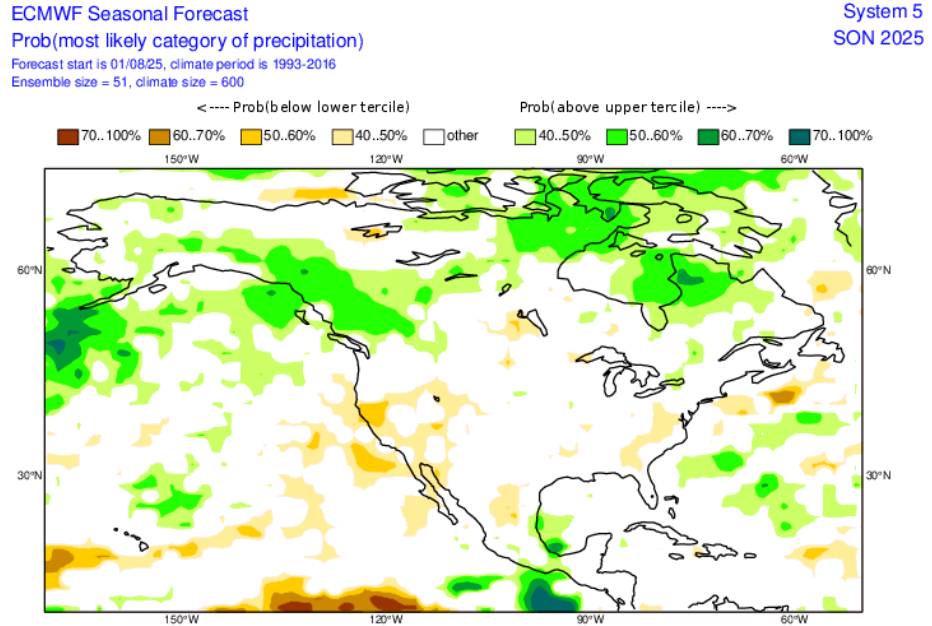
The Pacific Northwest and Ohio Valley are projected to receive above-average precipitation this fall. These wetter-than-normal conditions could lead to an increased risk of flooding and disruptions to transportation and outdoor activities. The additional rainfall may also benefit drought-stricken areas, replenishing water resources and reservoirs.
Southern United States
The southern U.S. is expected to remain drier than usual. Prolonged dryness could exacerbate drought conditions and strain water supply, impacting agriculture, energy, and ecosystem stability. This includes Texas, Louisiana, Florida, and the Gulf Coast, which are likely to see below-average rainfall throughout autumn.
🌪️ Severe Weather Outlook: Elevated Risks
Wildfire Activity
The combination of above-average temperatures and dry conditions in the western U.S. and southern Canada is likely to elevate wildfire risk. According to AccuWeather forecasts, the risk of wildfires will ramp up in September, while severe weather threats could return to the central Gulf Coast and Ohio Valley in October. Residents are advised to maintain high preparedness levels.
Hurricane Season
While the peak of the Atlantic hurricane season occurs in August and September, oceanic conditions may extend the season into October. Late-season tropical cyclones could pose risks to coastal communities, requiring continued monitoring, emergency planning, and hazard mitigation.
🌬️ Atmospheric Drivers: ENSO and NAO Influences
El Niño–Southern Oscillation (ENSO)
The ENSO is expected to shift from a neutral pattern to a cooler La Niña phase by November. This transition will influence weather patterns across North America, including:
- Drier conditions in the southern U.S.
- Wetter conditions in the Pacific Northwest
- Potential for colder winters in the northern U.S. and Canada
North Atlantic Oscillation (NAO)
The NAO is anticipated to be in a positive phase during September 2025. Typically, a positive NAO brings milder and wetter conditions to northern Europe and drier, warmer weather to southern Europe. While its direct influence on North America is smaller, NAO-driven circulation changes can indirectly affect storm tracks, cold air outbreaks, and precipitation patterns across the continent.
Madden-Julian Oscillation (MJO)
The MJO is expected to amplify tropical convection, influencing late-season hurricane activity in the Atlantic Basin. Strong MJO pulses may enhance storm formation and affect precipitation anomalies in the U.S. and Caribbean regions.
📊 Regional Outlooks
Northeast & Great Lakes
- Temperature: Below average
- Precipitation: Above average
- Impacts: Early-season snow and frost, potential lake-effect snow, agriculture and transport disruptions.
Midwest
- Temperature: Near to slightly below average
- Precipitation: Mixed; some regions wet, others dry
- Impacts: Early frost, harvest delays, potential localized flooding.
Southeast
- Temperature: Above average
- Precipitation: Below average
- Impacts: Extended growing season, increased drought stress, wildfire potential.
Southwest
- Temperature: Above average
- Precipitation: Below average
- Impacts: Elevated wildfire risk, water scarcity, energy system stress.
Pacific Northwest
- Temperature: Near to slightly above average
- Precipitation: Above average
- Impacts: Flooding risk, benefits for drought recovery, infrastructure concerns.
Alaska
- Temperature: Above average
- Precipitation: Below average
- Impacts: Reduced sea ice, earlier freeze-up, ecosystem stress.
🔮 Long-Term Considerations
The potential La Niña conditions for Winter 2025–2026 may bring:
- Colder, wetter conditions in northern U.S. and Canada
- Drier, warmer conditions in southern U.S.
- Increased variability in hurricane activity
Understanding ENSO progression, NAO shifts, and MJO pulses will be critical for winter preparedness and risk assessment.
Top 10 Teleconnections Influencing North America – Autumn 2025
Teleconnections are large-scale patterns in the atmosphere and oceans that influence regional climate and weather extremes. Understanding these helps forecast temperature, precipitation, storms, and seasonal anomalies.
1. El Niño–Southern Oscillation (ENSO)
Definition: ENSO is a periodic fluctuation in equatorial Pacific sea surface temperatures and atmospheric pressure.
Impact on North America:
- El Niño: Warmer Pacific waters bring mild winters to northern U.S. and Canada, wetter southern U.S., and suppressed hurricane activity.
- La Niña: Cooler Pacific waters favor colder, snowier conditions in the north, warmer, drier south, and enhanced Atlantic hurricane season.
Autumn 2025 Outlook: ENSO is expected to transition to La Niña, influencing cooling in the north and dryness in the south.
2. North Atlantic Oscillation (NAO)
Definition: Variation in atmospheric pressure between the Icelandic Low and Azores High.
Impact on North America:
- Positive NAO: Strong westerlies; mild, wet northern Europe, often correlates with warmer, drier eastern U.S.
- Negative NAO: Weak westerlies; cold outbreaks and snowstorms in the eastern U.S.
Autumn 2025 Outlook: Positive phase in early September may contribute to milder east coast conditions before cold outbreaks intensify.
3. Pacific Decadal Oscillation (PDO)
Definition: Long-term sea surface temperature patterns in the North Pacific.
Impact:
- Positive PDO: Warm coastal waters; enhanced west coast warmth, more precipitation in the northwest.
- Negative PDO: Cooler coastal waters; drier west coast, more winter storms inland.
Autumn 2025 Outlook: PDO likely neutral to slightly positive, supporting warm, dry conditions in the southwestern U.S..
4. Arctic Oscillation (AO)
Definition: Variation in polar vortex strength over the Arctic.
Impact:
- Positive AO: Strong vortex; cold air trapped north, milder mid-latitudes.
- Negative AO: Weak vortex; cold air outbreaks in central and eastern U.S., potential for early snow events.
Autumn 2025 Outlook: Fluctuating AO may trigger episodic cold snaps in the northeast and Midwest.
5. Madden-Julian Oscillation (MJO)
Definition: Tropical atmospheric wave that moves eastward along the equator every 30–60 days.
Impact:
- Modulates tropical storm formation, especially Atlantic hurricanes.
- Influences U.S. precipitation patterns, enhancing wet or dry periods depending on phase.
Autumn 2025 Outlook: Strong MJO pulses may enhance late-season hurricane activity in the Atlantic.
6. Atlantic Multidecadal Oscillation (AMO)
Definition: Long-term sea surface temperature fluctuations in the North Atlantic, lasting decades.
Impact:
- Warm AMO: Active Atlantic hurricane seasons, warmer eastern U.S. temperatures.
- Cool AMO: Reduced hurricane activity, cooler temperatures in the east.
Autumn 2025 Outlook: AMO is in a warm phase, potentially boosting late-season tropical activity.
7. Quasi-Biennial Oscillation (QBO)
Definition: Alternating westerly and easterly winds in the tropical stratosphere, changing approximately every 28 months.
Impact:
- Influences polar vortex stability.
- Affects the strength and frequency of winter cold outbreaks in North America.
Autumn 2025 Outlook: Current QBO phase may favor stronger polar vortex containment early, reducing initial cold outbreaks.
8. Pacific North American Pattern (PNA)
Definition: Atmospheric pressure pattern linking North Pacific and North America.
Impact:
- Positive PNA: High pressure in western U.S., low in southeast; warmer west, colder east.
- Negative PNA: Opposite; cooler west, milder east.
Autumn 2025 Outlook: Likely positive PNA, supporting warm western U.S. and dry southwest.
9. Tropical Northern Hemisphere Pattern (TNH)
Definition: Pressure anomaly pattern between northern Pacific and North America.
Impact:
- Modulates storm tracks, precipitation, and extreme weather events across eastern U.S.
Autumn 2025 Outlook: TNH variations may enhance cold-air intrusions and precipitation variability in the Midwest and Northeast.
10. Greenland Blocking / Scandinavian Pattern
Definition: High-pressure anomalies over Greenland or Scandinavia influencing North Atlantic flow.
Impact:
- Can redirect the jet stream, causing persistent heatwaves or cold spells in North America.
- Often leads to blocking events, prolonging warm or cold periods.
Autumn 2025 Outlook: Occasional Greenland blocks may trigger short-lived cold outbreaks in the eastern U.S., despite overall warmer patterns.
🧭 Conclusion
Autumn 2025 in North America is shaping up to be a season of contrasts. Western regions will enjoy extended warmth, while eastern regions prepare for early cold snaps. Precipitation patterns will vary, with some areas experiencing above-average rainfall, while others remain dry. The influence of teleconnections such as ENSO, NAO, and MJO will be key to anticipating regional extremes. Residents, governments, and industries must remain vigilant and prepared for the wide range of climate impacts this fall.
Mkweather Autumn 2025 Forecast for North America
💡 Summary of Teleconnection Impacts – Autumn 2025
| Teleconnection | Expected Phase / Trend | Key Impacts |
|---|---|---|
| ENSO | La Niña developing | Colder north, drier south, enhanced hurricane season |
| NAO | Positive early | Milder east coast, delayed cold outbreaks |
| PDO | Neutral-slightly positive | Warm west, dry southwest |
| AO | Fluctuating | Episodic cold snaps in east/north |
| MJO | Active pulses | Late-season tropical storm enhancement |
| AMO | Warm phase | Stronger late-season hurricanes, warm east |
| QBO | Containment of polar vortex | Reduced initial cold outbreaks |
| PNA | Positive | Warm west, dry southwest, colder east |
| TNH | Variable | Cold-air intrusions, precipitation anomalies |
| Greenland / Scandinavia | Occasional blocking | Cold outbreaks or extended warm periods |
Source: https://www.cpc.ncep.noaa.gov/products/CFSv2/CFSv2_body.html
Source: ECMWF Charts


