Development of Invest 98W to Tropical Storm or Typhoon: A Threat for the Northern Philippines, Taiwan, China, Koreas, and Japan
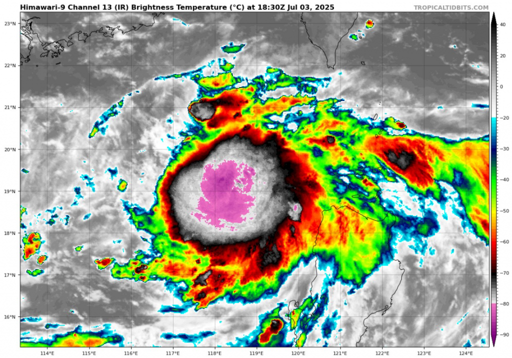
As of July 3, 2025, 18:00 UTC, Invest 98W is showing signs of significant development in the Western Pacific Ocean, located at approximately 19.5°N latitude and 119.5°E longitude. This system, currently classified as an “Invest,” is being closely monitored by meteorologists due to its potential to develop into a tropical cyclone within the next 24 hours.
Current Status and Characteristics
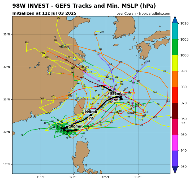
Invest 98W presently has maximum sustained winds near 20 knots (approximately 37 km/h or 23 mph), with a minimum central pressure measured at around 1004 millibars. The system’s radius of maximum winds extends roughly 145 nautical miles, indicating a broad circulation, though other specific details such as the radius of overall circulation remain undetermined. This broad wind field, combined with favorable environmental conditions, suggests a developing system that could intensify rapidly in the near term.
Geographical Context and Possible Trajectory
The system lies near the Batanes Islands in the northern Philippines, an archipelago located between the Luzon Strait and the South China Sea. Meteorological agencies suggest that Invest 98W is nearly a tropical cyclone at this stage and could become classified as a tropical depression or storm within the next 24 hours.
Forecast models currently agree on a gradual intensification of the system as it moves slowly northward, potentially impacting several countries and territories in East Asia. The projected path includes:
- Northern Luzon and the Philippines
- Taiwan
- The Ryukyu Islands of Japan
- Parts of continental China
- The Koreas
The system’s slow northward track means that these regions should prepare for increasing rainfall, gusty winds, and rough seas as the system approaches.
Environmental Conditions Favoring Development
Invest 98W is currently embedded in an environment conducive to tropical cyclone formation. Warm sea surface temperatures, adequate moisture in the mid-level atmosphere, and relatively low vertical wind shear create ideal conditions for the system’s strengthening.
Meteorologists note that the low pressure center is becoming more defined, and cloud organization around the center is increasing. As a result, there is a high probability that Invest 98W will develop into a tropical cyclone over the coming week.
While the system is still in the early stages of formation, its development rate warrants vigilance by affected countries, especially considering the historical impacts of tropical cyclones in the Western Pacific region.
Potential Impacts and Preparedness
If Invest 98W intensifies into a tropical storm or typhoon, it could bring heavy rainfall, flooding, landslides, and strong winds to vulnerable coastal and inland areas. In the Philippines, particularly the Batanes and northern Luzon regions, residents should monitor local weather bulletins and prepare for potential evacuations.
Taiwan and the Ryukyu Islands, which frequently experience tropical cyclones during the season, could face moderate to heavy rains and gusty winds, disrupting transportation and causing localized flooding.
Parts of mainland China, as well as South and North Korea, might also experience weather disturbances related to the system, depending on its eventual trajectory and strength.
Authorities in all potentially affected countries should stay alert, issue timely warnings, and prepare emergency response plans in the event the system strengthens and makes landfall or causes indirect impacts.
Forecast Uncertainties
Despite consensus on general development and northward movement, exact timing, intensity, and landfall locations remain uncertain at this stage. Forecast models sometimes differ on the speed of intensification and track details, especially beyond the first 3-5 days.
Additionally, interactions with atmospheric features such as the subtropical ridge or mid-latitude troughs could alter the storm’s course or weaken/strengthen its intensity unexpectedly.
Summary
Invest 98W is a tropical disturbance showing signs of imminent development near the northern Philippines. With favorable environmental conditions, it is likely to become a tropical depression or storm within 24 hours and continue to track slowly northward toward Taiwan, the Ryukyu Islands, parts of China, and possibly the Koreas and Japan.
All countries in the Western Pacific and East Asia regions should monitor updates closely, maintain preparedness measures, and stay informed via official meteorological agencies.
Sources
- National Oceanic and Atmospheric Administration (NOAA) – Tropical Weather Outlook
- Joint Typhoon Warning Center (JTWC) – Invest Advisories
- Philippine Atmospheric, Geophysical and Astronomical Services Administration (PAGASA)
- Japan Meteorological Agency (JMA)
- Regional satellite and weather model analysis from July 2025
Source: https://www.tropicaltidbits.com/storminfo/#98W


