Summer 2020 is ending and it´s time for first seasonal climatological outlook of Autumn 2020.
Weather in autumn 2020 in Europe will be affected by many teleconnections, weather patterns and climate change parameters, which were considered within following overview.
A few very important parameters will be affecting temperature and precipitation patterns over Europe in September, October and November 2020:
- 1.) Weakened meridional temperature and pressure gradient (weaker Icelandic lo and weaker Azores high than usual), NAO- and AO-
During autumn 2020, seasonal forecasts /https://www.cpc.ncep.noaa.gov/products/CFSv2/CFSv2_body.html/ are expecting lower temperature and geopotential (pressure) meridional gradient between northern and southern latitudes. Icelandic low will be weaker, Azores high too, what is linked with more frequent NAO- / AO- phases.
During NAO- / AO- phases, pressure lows goes from Atlantic over Europe past southern tracks, with more frequent cold spells, in late autumn snowing. NAO- / AO – is in November linked with La-niňa, what can boost early coldwaves in winter season 2020/21. NAO- during first half of autumn means longer coldaves and shorter, but intensive heatwaves in warm sectors of low pressure systems, often ex-hurricanes or ex-tropical storms such as windstorms over Europe. With weakening tropical storm activity, together with La-niňa, QBO easterlies phase and possibly MJO favorable phases, really winter conditions could arrive during late Autumn 2020 across large parts of Europe. In September, during short heatwaves in warm sector, in contrary, could be reached a new temperature records.
- 2.) Boosted hurricane season, MJO and strong ex-hurricanes, ex-tropical storms and windstorms in Europe
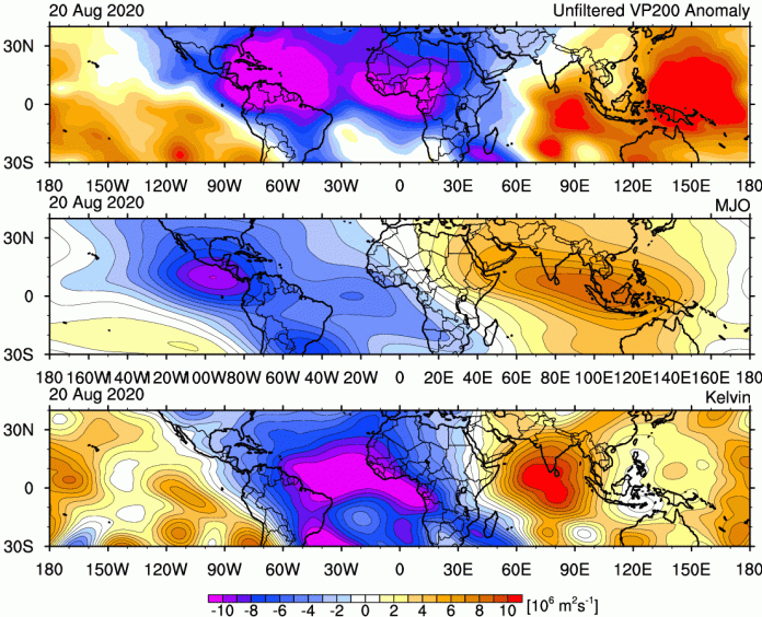
Other Services announced /https://www.severe-weather.eu/tropical-weather/kelvin-wave-atlantic-hurricane-forecast-fa//, that favorable phases MJO will boost hurricane season during first half of September 2020 – the coming peak of hurricane season 2020.
Kelvin waves and wet MJO pattern is moving from Africa over Atlantic and North American sector after 20. August 2020, what will be linked with increased formation of hurricanes and tropical storms, and therefore, formation of windstorms and rainstorms over European sector as ex-hurricanes and ex-tropical storms.
It will be linked with more windy, rainy and stormy patterns in NW and W coast of Europe, but too with longer significant coldwaves in Europe after their shifting to E-NE, mainly in Central Europe and moderate zones, but too with possible medicanes in Mediterranean.
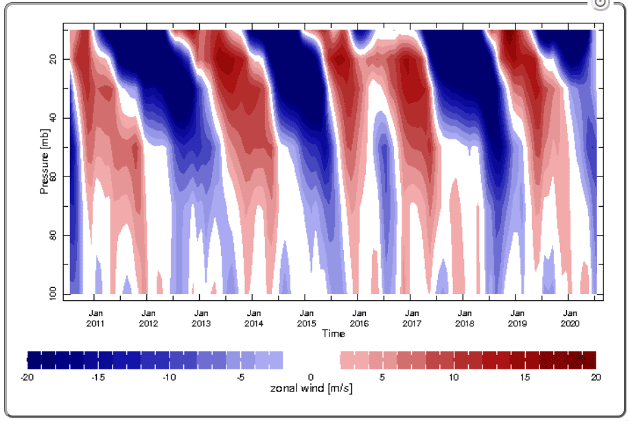
- 3.) QBO in strong easterly phase
QBO strong easterly phase is expecting during autumn 2020 and early winter 2020/21, with more than usual easterlies and less westerlies over Europe. A change is expecting during second half of winter 2020/21 with worsening of winter conditions.
- 4.) Recorded Arctic melting in summer and autumn 2020:
Possible new minimum of Arctic sea ice area in September 2020 can be linked with stronger NAO-/AO- phases, Siberian snow cover and Global warming hole anomaly in North Atlantic. It can help sustain southern stormtracks of pressure lows with relative colder conditions.
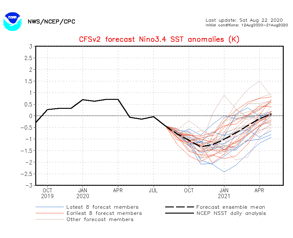
- 5.) Still La-niňa pattern
La-niňa is expected during autumn 2020. It´s a colder phase of Southern Oscillation, in other months linked mainly with NAO+/AO+, what plays against meridional jet-stream formation and against “climate change direction”. However, pattern is during late autumn significantly linked with NAO- and AO- pattern with increased coldwaves in Europe – it is an exception.
- 6.) Siberian snow cover
A lot of humidity running from melting Arctic will cause enormous snowfalls in Siberia and parts of Northern Hemisphere, with positive effect on early coldwaves during autumn 2020. This pattern during the winter with less humid masses stocks is weakening and in the spring, less snowfall than in the past is occuring. Autumn is main season of the year, when snow areas in the Northern Hemispheres are larger than in the past.
- 7.) Global warming hole in North Atlantic and more shifted stormtrack to south as usual
Melting in the Arctic will cause more fresh and cold waters in Labrador stream, which will push Gulf stream near Farm Strait to the south. Gulf stream can be shifted more than 100 km southerly, what can have impact to Norway, British Isles, Biskay bay and Portugal with periodical coldwaves mainly during autumn season, when Arctic melting is on maximum.
- 8.) Correspondence with forecast for winter 2020/21
Although forecast for Autumn 2020 is very favourable for early coldspells and overall colder, rainy or snowy conditions, respectively, during winter 2020/21 we are expecting a change – QBO will shift to westerlies phase, from La-niňa we will have El-niňo again, NAO- and AO- will change to NAO+ and AO+ (see maps below – warm Canada and Great Lakes area is predictor of NAO-/AO- and cold Canada and Great Lakes area a predictor of NAO+/AO+). Winter 2020/21 had to start with cold conditions, but second half of winter can be warm in Europe. Autumn 2020 forecast is corresponding with our Winter 2020/21 forecast for Europe and North America. /https://mkweather.com/2020/07/29/first-forecast-for-winter-2020-21-early-powerful-coldwaves-nov-dec-then-weakening-of-cold-pattern-and-warm-jan-feb-mar//.
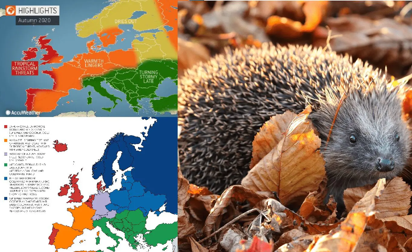
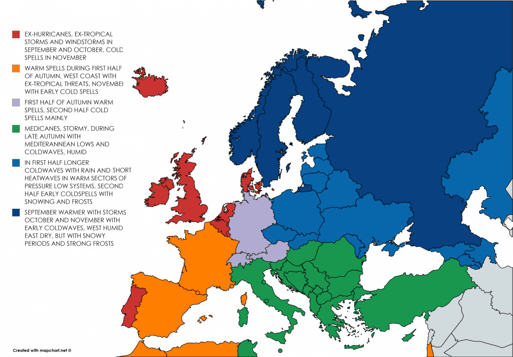
Mkweather Autumn 2020 forecast:
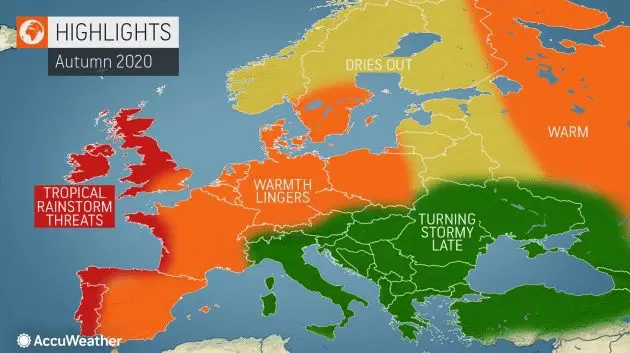
Accuweather Autumn 2020 forecast:
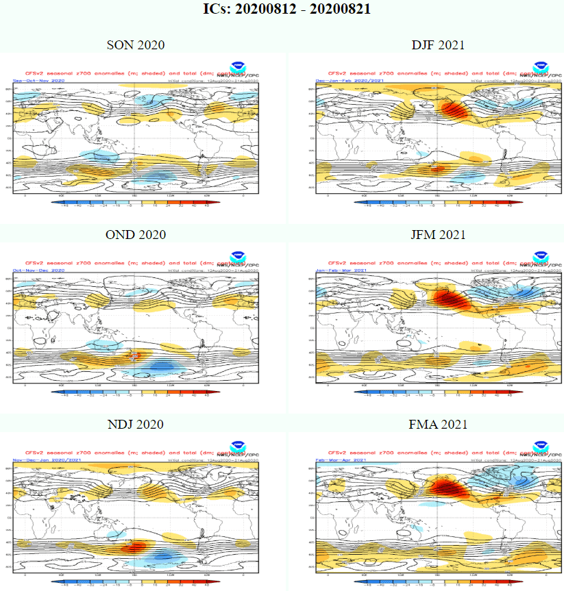
700hPa geopotential (pressure analogy) over World – Autumn 2020 with weaker differences between Icelandic low and Azores high (NAO-/AO-), Winter with strong pressure gradient between Icelandic low and Azores high (NAO+/AO+) /NOAA:
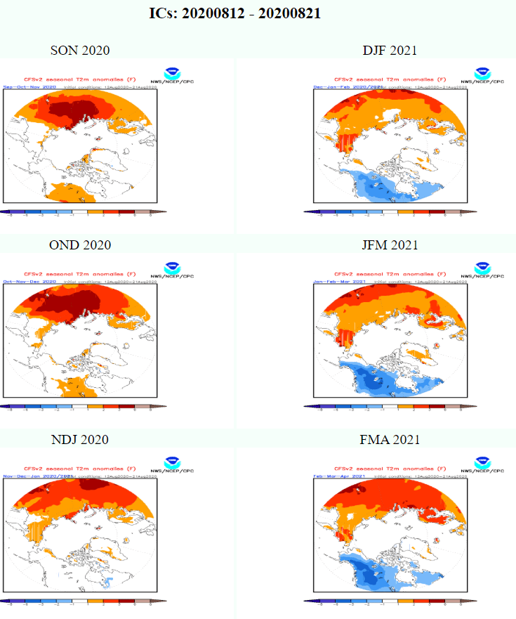
Canadian and Great Lakes sector can tell us a lot about expected NAO/AO phase – cold Canada and Great Lakes means NAO+/AO+ and reversely, warm Canada and Great Lakes means NAO-/AO- /NOAA
Expected MJO and Kelvin wave will boost hurricane season in first half of September 2020 /Severe Weather Europe:
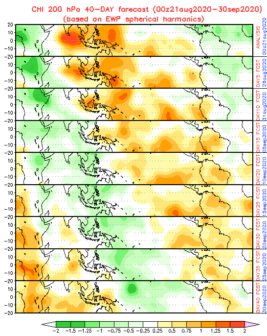
Expected MJO till 30. September 2020 /NOAA:
La-niňa in Nino3.4 region is expected during Autumn 2020 /NOAA:
During the Autumn 2020, blue – “easterlies” phase will expand, with more easterly winds than usual /https://iridl.ldeo.columbia.edu: