EUROPE AUTUMN 2025 SEASONAL OUTLOOK: FROM NAO+ AND WARMTH TO NAO- AND COLD
Period: September–October–November (SON) 2025
Scope: Temperatures, precipitation, wind, humidity, snow cover, air pressure, sunshine & cloudiness, with drivers (NAO, ENSO, QBO, MJO, Atlantic hurricanes, solar, volcanoes, SSTs/AMV, IOD, AO, sea-ice, Eurasian snow) and regional month-by-month outlooks.
Autumn 2025 in Europe will unfold under the influence of a complex interplay of global and regional climate drivers. Large-scale teleconnections point toward a dynamic and often changeable season, with significant month-to-month variability. The North Atlantic Oscillation (NAO) is projected to average slightly positive over the season, but with notable sub-seasonal swings: a positive phase in September, a tendency toward neutral to slightly negative in October, and possible blocking episodes in late November. The Arctic Oscillation (AO) will mirror this pattern, with mild early conditions across much of Europe, then a greater risk of polar air intrusions late in the season.
The El Niño–Southern Oscillation (ENSO) is forecast to remain in a decaying El Niño state through early autumn, transitioning toward neutral by November. This evolution often correlates with an active Atlantic storm track in early autumn, then greater variability later. The Quasi-Biennial Oscillation (QBO) will be in its westerly phase, which tends to support a stronger polar vortex in early season but does not preclude late-autumn blocking. The Madden–Julian Oscillation (MJO) may become more influential during October, with possible pulses through phases 6–7–8 that could trigger cold air advection into Europe from Siberia toward the end of the season.
Atlantic hurricane activity is expected to be above average, with warm Main Development Region SSTs and favorable atmospheric conditions. The recurvature of late-season tropical cyclones toward the North Atlantic could energize the jet stream and lead to intense wind and rainfall episodes, particularly for Western Europe.
Other drivers also play a role: the Atlantic Multidecadal Oscillation (AMO) remains positive, keeping North Atlantic waters warmer than normal, while the Indian Ocean Dipole (IOD) is projected to stay neutral. The “global warming hole”—a region of persistently cooler SSTs south of Greenland and Iceland—continues to influence the pressure pattern over the North Atlantic, favoring troughing in that region and downstream ridging into Western and Central Europe during early autumn. Eurasian snow cover anomalies are expected to develop more rapidly than average in October, increasing the risk of late-season high-latitude blocking. Arctic sea ice extent anomalies remain negative overall, but with patchy recovery in the Kara and Laptev Seas, which could feed into late-autumn cold air availability. Solar activity remains elevated in its current cycle, with possible indirect effects on polar stratospheric processes, and volcanic aerosol loading in the atmosphere is low, meaning no major radiative cooling from eruptions is anticipated.
I. Executive Snapshot, Monthly Outlook and Seasonal Summary
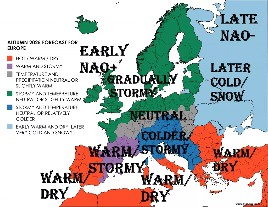
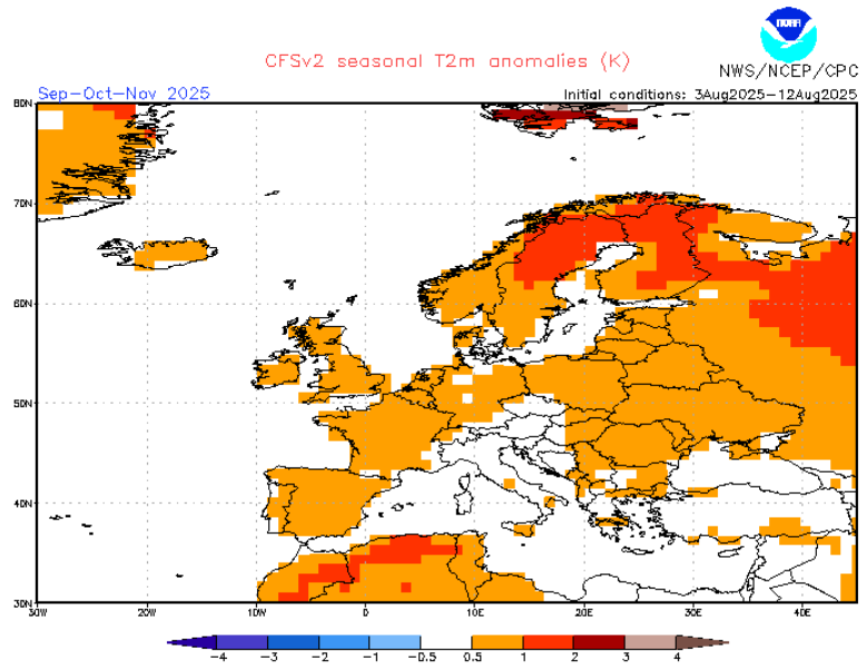
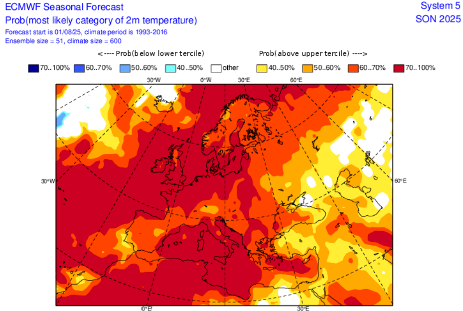
- Overall tilt: Slightly warmer than the 1991–2020 normal for most of Europe, with largest warm anomalies in the North/NE in September and in the Mediterranean in October–November.
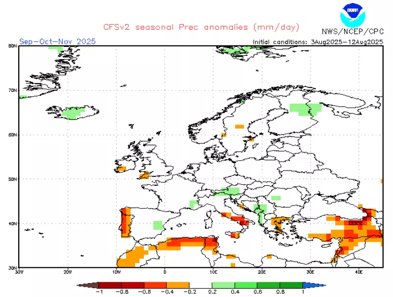
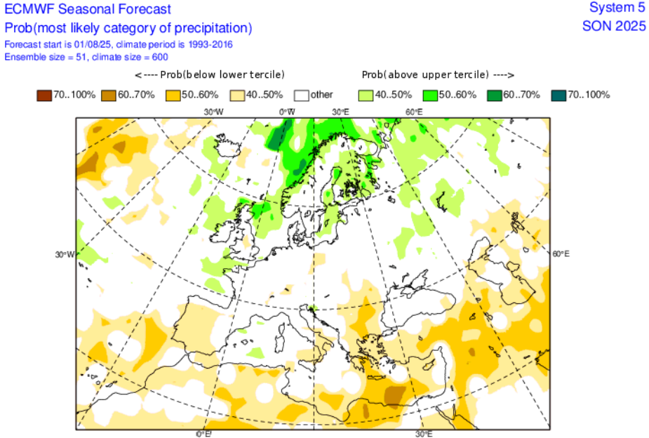
- Rainfall: A north–south dipole is most likely on seasonal mean: wetter than normal tendencies across NW/North Europe and parts of the Balkans/Adriatic, with drier signals favored at times for the western/central Mediterranean and Iberia; however, month-to-month reversals are likely.
- Storminess: Peak Atlantic cyclone activity aimed at Europe most likely in October–November, with windier episodes for the British–North Sea–Scandinavian corridor.
- Early snow: Chances for early-season snow increase over Scandinavia, the Alps, Carpathians, and the East European Plain in late October–November during transient cold shots.
- Confidence: Moderate on the seasonal mean; low–moderate at the monthly/regional scale (high intra-seasonal variability).
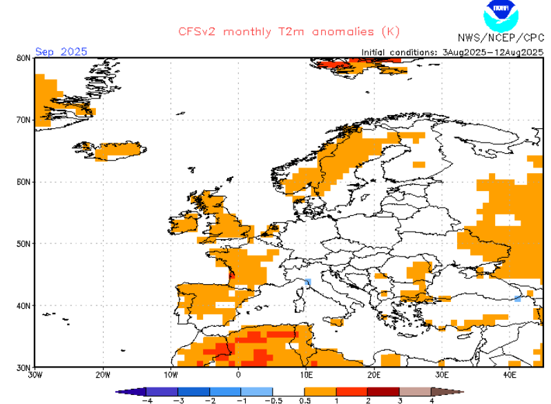
September 2025
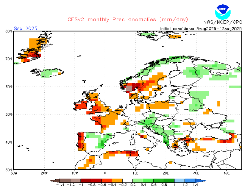
September is expected to open with a strong positive NAO and AO phase, maintaining a vigorous westerly flow into Northern and Western Europe. This will lead to warmer than average conditions in Scandinavia, the British Isles, and much of Central and Eastern Europe, while the western Mediterranean and parts of Iberia remain near or slightly below average due to local troughing. The main storm track will arc from the North Atlantic into Scandinavia, bringing above-normal rainfall to Norway, Sweden, and parts of Scotland, with occasional windstorms. Sunshine will be limited in these areas, while Southern Europe experiences clearer skies and higher sunshine hours.
The Iberian Peninsula will see a north–south contrast: northern Iberia wetter under Atlantic fronts, southern Iberia drier and sunnier under subtropical ridging. In Central Europe, September will be generally warm, with precipitation near or slightly above normal depending on frontal activity. Eastern Europe and the Balkans will be under transient ridges, with warm, dry spells interrupted by short-lived cold fronts. The Mediterranean will be mostly stable, though the Adriatic and Ionian Seas may see early cut-off lows producing heavy localized rainfall.
Sea surface temperatures around Europe will remain above average, particularly in the eastern Atlantic, feeding warm and moist air into the storm systems. Wind speeds will be strongest over the North Atlantic and North Sea, but gales in the Mediterranean will be rare. Humidity will be moderate to high in Northern Europe, lower in the south. Snow cover will be negligible except on the highest Alpine peaks.
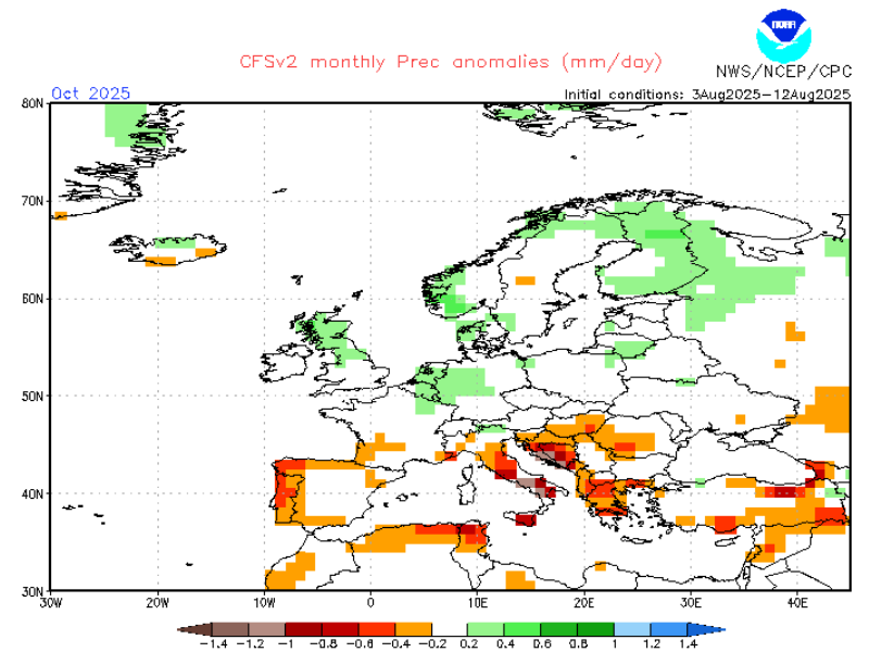
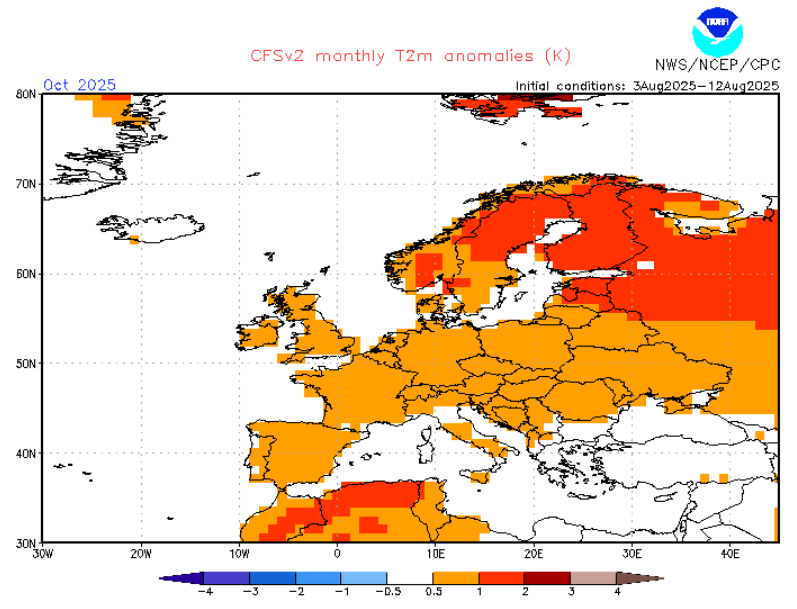
October 2025
October will mark a transition month, with NAO trending toward neutral or slightly negative phases at times. This will allow for more frequent blocking patterns in the North Atlantic and Scandinavia, occasionally deflecting the storm track southward. Early in the month, lingering warmth in Southern Europe will contrast with cooler, more unsettled conditions in the north. Later in October, cold polar maritime air masses will increasingly reach Northern and Central Europe, dropping temperatures toward or slightly below average in these regions.
Western Europe will see alternating mild and cool spells, with active Atlantic fronts bringing heavy rainfall to the British Isles, France, Benelux, and northern Iberia. The Mediterranean Basin will be more unsettled than in September, with cyclonic activity generating heavy rains, especially along the western and central coasts, the Balearics, Sardinia, Corsica, and Italy. The Balkans will also experience periodic downpours as Genoa lows track eastward.
Central and Eastern Europe will have a mixed pattern: the first frosts will appear in Poland, Ukraine, and parts of the Balkans by mid-month. Humidity levels will rise in Mediterranean and Balkan storm episodes, while sunshine will decrease across much of the continent compared to September. Snowfall will start to occur more frequently in Scandinavia, the Alps, and higher elevations of the Carpathians, and occasional snow flurries could reach the lowlands of northern Scandinavia by late October.
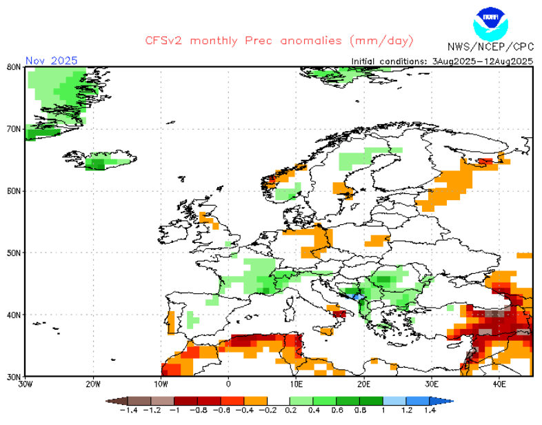
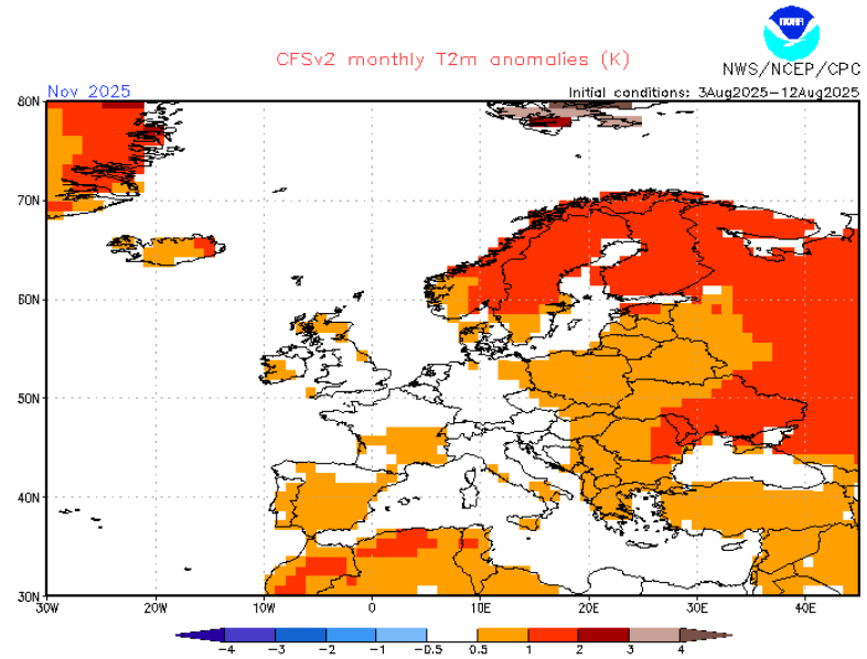
November 2025
November is projected to be more variable and potentially more severe, with increasing blocking episodes over Scandinavia and the Ural region by the second half of the month. The NAO may dip into negative territory for periods, allowing Arctic air masses to spill into Eastern and Central Europe. The western Mediterranean and Balkans may see repeated cyclogenesis events, driving heavy rainfall and mountain snowfall.
Northern and Western Europe will face frequent Atlantic storms, especially early in the month, with strong winds and heavy rain. Later in November, high pressure over Greenland or Scandinavia could bring colder, drier weather to NW Europe, with frost and occasional snow showers in the north. The British Isles may experience a north–south split: wetter and milder in the south, colder and drier in the north.
In Central Europe, November will bring a heightened risk of early-season snow, particularly in Germany, Austria, Czechia, and Poland, especially if blocking establishes. Eastern Europe, including Ukraine and western Russia, will trend colder than average by late month, with the first persistent snow cover possible in northern sections. The Mediterranean will see strong contrasts: Spain’s southeast and parts of the Levant could remain drier, while Italy, the Adriatic coast, and Greece face wetter conditions due to repeated low-pressure incursions. Snow will accumulate in the Alps, Carpathians, Dinaric Alps, and Anatolian highlands, and Arctic air intrusions could drive snow to lower altitudes in Central and Eastern Europe before winter officially begins.
Seasonal Summary
Overall, Autumn 2025 will be mild to warm in early season, especially in September, before turning progressively cooler and more unsettled into November. Precipitation will be above normal in much of Northern and parts of Central Europe, especially in October and November, and below normal in parts of southern Iberia and the eastern Mediterranean. The Mediterranean storm season will be active from October onward, and late-season blocking could lead to significant early-winter cold spells in Eastern Europe.
Snow cover will develop early in Scandinavia, the Alps, and parts of Eastern Europe, with possible notable anomalies by late November in the east if blocking patterns persist. Sunshine will be most plentiful in Southern Europe in September and during any early-autumn ridging episodes, while Northern Europe will see extended cloudy, wet spells.
II. Key Drivers & Teleconnections (Autumn 2025)
ENSO (El Niño–Southern Oscillation)
- State: Favoring ENSO-neutral trending weak La Niña into late autumn.
- Impact: Weak La Niña teleconnections are subtle in SON, but can gently favor more zonal Atlantic flow periods early, then blocked/meridional breaks later—supporting wet/windy bursts NW/North and occasionally dry/warm spells S/SW.
North Atlantic SSTs & AMV
- Setup: North Atlantic remains anomalously warm overall, with a persistent cool patch (“global warming hole”) near S Greenland/Iceland embedded in warmth elsewhere.
- Impact: Warm basin + subpolar cool patch supports baroclinic contrast, aiding storm development aimed at NW Europe, while Mediterranean SSTs in early autumn can energize convective rain events during cutoffs.
NAO & AO
- Trend: Slight lean to neutral / weakly positive NAO early autumn, becoming variable/near-neutral later.
- Impact: Early-season westerlies into UK/North Sea/Scandinavia, punctuated by blocking episodes later that can spill colder air into Central/Eastern Europe and enhance Mediterranean cyclogenesis.
QBO (Quasi-Biennial Oscillation)
- Phase: Easterly (EQBO) descending through boreal autumn.
- Impact: Slight background influence on jet latitude and polar vortex preconditioning, with episodic high-latitude blocking bursts possible late in the season.
MJO / Intra-seasonal Variability
- Behavior: Expect 1–2 significant MJO pulses to project onto the Indian Ocean/Maritime Continent sectors during SON, capable of 2–3 week regime flips.
- Impact: Can swing Europe between wet/windy NW bursts and calm/warm S breaks.
Atlantic Hurricane Season Coupling
- Activity: Above-average tropical Atlantic activity can seed recurving extratropical remnants; elevated risk of plume-driven rain/wind into Iberia–France–UK windows in September–October.
Solar Cycle & Volcanoes
- Solar: Near cycle-25 peak/plateau—minor influence for autumn synoptics.
- Volcanic aerosols: Background slightly elevated stratospheric aerosol—only second-order seasonal effects expected.
Arctic Sea Ice & Eurasian Snow
- Sea ice: Below-average extent persists; open Barents/Kara pockets can modify storm tracks and Scandinavian thermal contrasts in October–November.
- Snow advance: Likely near to slightly above normal over Siberia’s interior, favoring later-season continental cold reservoirs.
III. Regional Codes
- [ICE-ISL] Iceland & Faroes
- [NW-ATL] W/NW Scotland, W Ireland, Norwegian Sea coasts
- [BI-NS] UK east, Benelux, NW Germany, W Denmark
- [SCAND-N] N Norway/Sweden/Finland, Barents
- [SCAND-S] S Norway/Sweden, Denmark, Baltic States, N Poland
- [FRA-ALP] France–Alps–SW Germany–Switzerland–W Austria
- [CEE] E Germany, Poland, Czechia, Slovakia, Hungary, E Austria
- [ALP-CARP] Alps & Carpathians highlands
- [IBER-W] W/NW Iberia & Bay of Biscay coast
- [IBER-E/MED] E/S Iberia & Balearics
- [ITA-ADR] Italy & Adriatic Coasts
- [BALK-SE] Balkans & N Aegean
- [MED-E] Greece, Cyprus, S/T coastal Turkey
- [ANAT-BLK] Anatolian Plateau & Black Sea coasts
- [EE-PLAINS] Ukraine, Belarus, W Russia, Moldova
IV. Monthly Outlooks
September 2025
- Pattern: Late-summer warmth, active Atlantic into NW/North, occasional tropical-remnant plumes, cutoffs in W/C Mediterranean.
- Warm anomalies: CEE, BALK-SE, SCAND-S.
- Wet spots: NW-ATL, BI-NS, IBER-W.
- Dry risks: MED-E, parts of IBER-E/MED.
October 2025
- Pattern: Transition month, stronger jet, more frequent Atlantic storms into NW, Mediterranean lows increasing.
- Wet spots: NW-ATL, BI-NS, ITA-ADR, IBER-W, SCAND-N.
- Heavy rain/flood risk: Valencia/Balearics/Catalonia, Gulf of Genoa/Ionian.
- Early snow: Alps >1500 m, Carpathians, Scandinavian highlands.
November 2025
- Pattern: Meridional exchanges, blocking windows, cold plunges into Central/Eastern Europe, active Atlantic into NW.
- [ICE-ISL]: 120–170% precip, widespread inland snow.
- [NW-ATL]: Windy, hill snow late.
- [CEE]: Frequent swings, frost risk, first lowland wet snow east.
- [IBER-W]: Stormy, flood risk windward slopes.
- [ITA-ADR]: Wettest N Adriatic, Alps snow to 600 m in cold shots.
- [BALK-SE]: Heavy rain in lows, mountain snow >800 m.
- [EE-PLAINS]: First lasting snow cover in N/E sectors.
V. Seasonal Summary
Temperature Tendencies:
- Warm: Mediterranean, Eastern Europe early season, NW September.
- Near normal: NW/N late autumn, Central Europe.
- Cool risk: Eastern/Nordic late November under blocking.
Precipitation Tendencies:
- Wet: NW Europe, Scandinavia, Northern Balkans.
- Dry: SW Iberia, SE Mediterranean (seasonal mean).
Snow:
- Early season: Scandinavia, Alps, Carpathians from October.
- Lowland snow possible Eastern Europe in November.
Wind:
- Strongest: North Atlantic–North Sea corridor Oct–Nov.
Cloudiness/Sunshine:
- Sunnier: Southern Europe in September/high-pressure breaks.
- Cloudier: NW/N Europe in westerly regimes.
AUTUMN 2025 FORECAST FOR EUROPE:
SEASONAL
MONTHLY
Source of CFS maps: https://www.cpc.ncep.noaa.gov/products/CFSv2/CFSv2_body.html
Source of ECMWF forecast: https://charts.ecmwf.int/?


2 thoughts on “EUROPE AUTUMN 2025 SEASONAL OUTLOOK: FROM NAO+ AND WARMTH TO NAO- AND COLD”
Comments are closed.