Ex-Hurricane Erin hit Europe with Winds up to 160 km/h, 14 m Waves and 200 mm Rainfall!
Hurricane Erin, which briefly reached Category 5 intensity over the central Atlantic, eventually recurved northeastward and transitioned into a powerful extratropical cyclone before striking Europe. At peak strength over the tropics, Erin featured sustained winds around 260 km/h and a central pressure near 915 hPa, placing it among the most intense Atlantic hurricanes ever recorded. Though it weakened over cooler waters, its enormous circulation and stored tropical moisture meant that its remnants had continent-wide impacts once it merged with the North Atlantic jet stream.
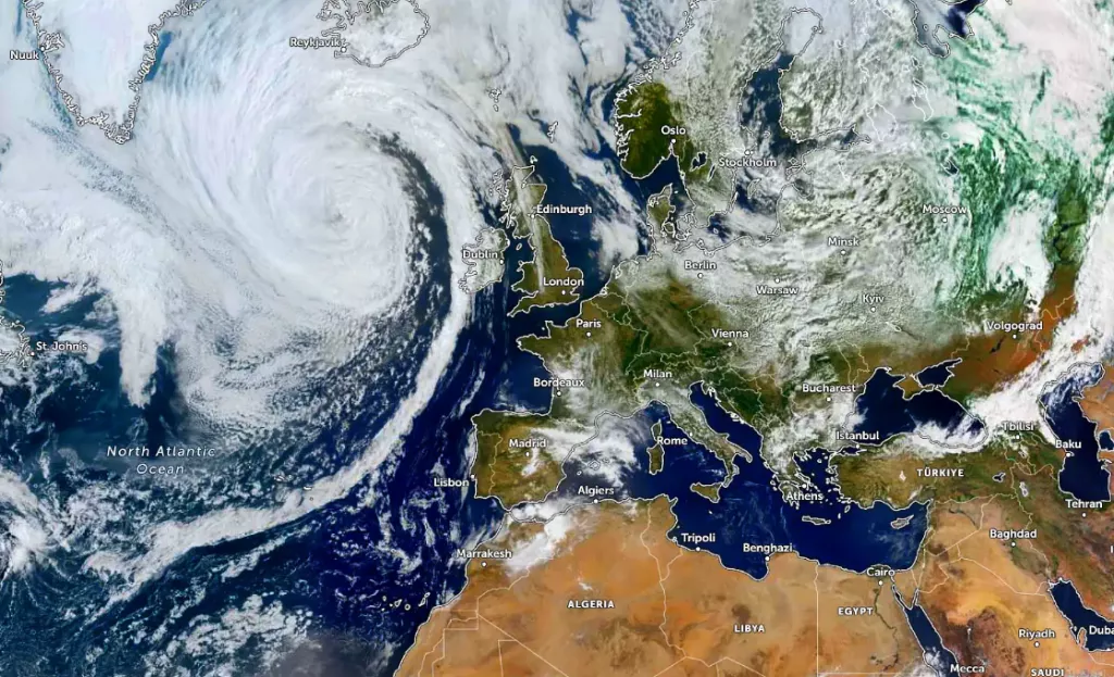
As Erin approached western Europe, its extratropical transition deepened the system rapidly, producing a sub-950 hPa low pressure as it entered the Bay of Biscay and the British Isles. Ireland, the UK, and northern France experienced hurricane-force gusts locally exceeding 140–160 km/h, causing widespread power outages, transport disruption, and coastal flooding. Wave buoys off the Celtic Sea registered 12–14 m significant wave heights, while the Bay of Biscay saw intense storm surges and coastal erosion.
Further inland, Erin’s vast moisture plume was entrained into the mid-latitude frontal structure, leading to exceptional rainfall totals. The western Alps, Massif Central, and northern Spain saw 100–200 mm in 48 hours, triggering landslides and river flooding. Central Europe (Germany, Switzerland, Austria, Czechia, Poland) experienced both flood-producing rains and strong winds of 90–120 km/h, unusually high for an ex-hurricane so far from the Atlantic.
As the system accelerated northeastward, Scandinavia was struck by gales, with Norway’s fjords recording gusts above 120 km/h and heavy orographic rainfall exceeding 150 mm. In the Baltic States and Finland, Erin’s remnants caused prolonged storm surges along the Baltic Sea, with water levels 1–1.5 m above normal.
Meanwhile, on Erin’s southeastern flank, a warm subtropical air mass surged northward, creating extraordinary late-season temperature anomalies. Parts of Italy, the Balkans, and Hungary experienced temperatures 8–10 °C above average, setting local records for late summer warmth. The juxtaposition of record warmth in the southeast and violent storm conditions in the northwest highlighted the continent-wide reach of this hybrid system.
Overall, Ex-Erin stands out as a historic Europe-wide storm event: while it no longer carried the compact eye and symmetry of a Category 5 hurricane, its remnant circulation, frontal development, and extreme moisture transport made it one of the most destructive extratropical systems of recent decades, impacting nearly every corner of Europe through a combination of wind, rain, waves, surges, and temperature extremes.
Satellite image of ex-Erin. Source: https://pogodnik.com/en/news/ex-hurricane-erin-in-eu-260852?srsltid=AfmBOopBOLnjgVIA9-I8aB9SV_419_Ss1BoSUSHWiDpGrk8z0MM4Q9dJ
| Region | Peak Gusts (km/h) | Rainfall (mm) | Storm Surge / Waves | Temperature Anomalies | Main Impacts |
|---|---|---|---|---|---|
| Ireland & UK | 140–160 (locally 170 coastal headlands) | 50–90 | 3–4 m storm surge, waves 12–14 m in Celtic Sea | Slightly above average, warm sector intrusion | Power outages > 500k homes, coastal flooding, transport paralysis |
| Northern France & Benelux | 120–150 | 70–120 | 2–3 m surge along Channel coast | +4 °C above normal | Severe wind damage, flooding in Normandy & Brittany, port closures |
| Spain (Northwest & Basque Country) | 100–130 | 100–180 (localized >200 in mountains) | 4 m Atlantic surge, erosion in Bay of Biscay | Near normal | Flash floods, landslides, crop damage |
| Portugal (North) | 90–120 | 60–110 | 2–3 m waves | Near normal | Flooding of Douro basin, disruption of shipping |
| Alps (France, Switzerland, Austria, Italy North) | 90–110 (foehn gusts 120+) | 120–200 widespread, localized >250 | N/A | +6 °C warm föhn intrusions | River floods, landslides, glacial melt surge |
| Germany (West & South) | 90–120 | 80–150 | N/A | +4–6 °C above normal in warm sector | River flooding (Rhine, Danube), transport & forest damage |
| Central/Eastern Europe (Poland, Czechia, Slovakia, Hungary) | 80–100 | 60–120 | N/A | +6–10 °C above normal, local records for August heat | Record late-summer heat, flooding in Carpathians, agriculture losses |
| Italy & Balkans | 70–90 (Adriatic 100+) | 40–80, locally >120 in Dinaric Alps | Adriatic surge 1 m | +8–10 °C (late-season heatwave) | Record heat, vineyards/olive crops stress, flooding in mountain valleys |
| Scandinavia (Norway, Sweden, Denmark) | 100–130 (fjords 140+) | 100–150 orographic | 2 m Baltic surge | +2–4 °C | River flooding, damage to forests, shipping disruption |
| Baltic States (Estonia, Latvia, Lithuania) | 80–100 | 60–90 | 1–1.5 m surge in Gulf of Riga & Klaipėda | Slightly above average | Flooded coastal areas, port damage, transport delays |
| Finland | 70–90 | 50–80 | 1 m Baltic surge | +2–3 °C | Forest windfall, lake flooding, ferry cancellations |
| Eastern Europe (Ukraine, Belarus, Romania) | 60–80 | 40–70 | Black Sea locally 1 m surge | +6–9 °C | Warm anomalies, agricultural stress, transport disruption |


