Extreme Precipitation Across Central Europe, From Drought to Flood Waters Within Days
In the weeks leading up to the beginning of June, 2025, many regions in Northern and Central Europe endured a significant drought, with precipitation deficits persisting since early spring. Hydroelectric output across the Alps and Danube catchment fell by 13% from January to May 2025 compared to the previous year, marking the lowest May output since 2017 and signaling below-average snowmelt and rainfall in critical watersheds (reuters.comun-spider.org). Meteorological services reported “moderate” to “severe” drought conditions across eastern Poland, western Germany, Austria, and the Czech Republic throughout April and May, leading to low river flows, stressed agriculture, and early water-use restrictions in sectors ranging from farming to hydroelectric generation (un-spider.orgemergency.copernicus.eu). This antecedent lack of moisture set the stage for a rapid rebound into near-flood conditions once torrential rains began on June 3rd, 2025.
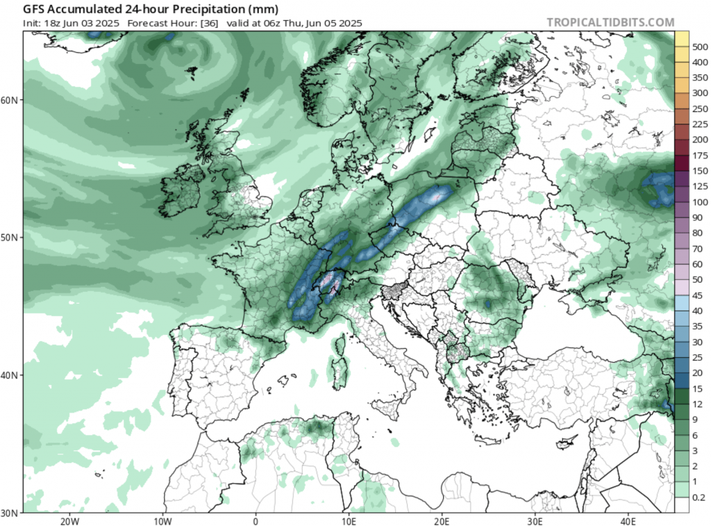
Between June 3rd and June 5th, 2025, a series of intense low-pressure systems traversed Central Europe, producing widespread thunderstorms, torrential rain, and significant flooding. In the Czech Republic and southwestern Poland, persistent rainfall led to rapidly rising river levels. By June 4th, water gauges in regions such as Jeseníky and Krkonoše reported between 100 and 170 millimeters of rain within a 24-hour period—well above typical early June totals—triggering third-level flood alerts along the Malše and Vltava rivers in southern Bohemia. Fire brigades in Mikulovice (Jeseník District) erected sandbag barriers as runoff from surrounding fields inundated homes, garages, and roadways. Meanwhile, in Poland’s Opole Voivodeship, the Biała Głuchołaska River and the Morawa swelled beyond their banks, forcing the evacuation of several villages and prompting a state of emergency in Lower Silesia.
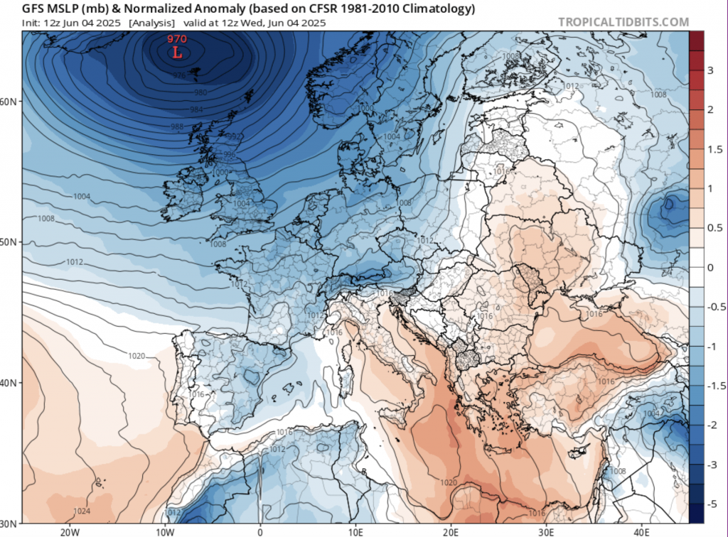
In Germany and Austria, accumulated rainfall since June 3rd ranged from 60 to over 100 millimeters in many Alpine foothills and low-lying areas. In Bavaria, towns like Triftern (Rottal-Inn District) witnessed floodwater surges on June 3rd that submerged streets and damaged structures; the town of Passau declared a local flood emergency as minor tributaries overflowed into the Danube floodplain. Rail services between Bad Hofgastein and Bad Gastein in Salzburg were suspended due to saturated tracks, and some high-mountain passes in Tyrol briefly closed as up to 50 centimeters of wet snow fell above 1,500 meters on June 4th. Austrian meteorological services warned of a potential 100-year flood event in the Waldviertel region after gauges in Lilienfeld recorded 369 millimeters of rain over the preceding 72 hours.
Switzerland and southern Germany also endured localized but severe convective cells. On June 4th, hailstones up to 7 centimeters in diameter pummeled parts of eastern Switzerland and southern Bavaria, stripping facades, shattering windows, and flattening crops as storms transitioned into bow-echo structures. Innsbruck and Salzburg reported 80–120 millimeters of rain on June 5th, prompting landslide warnings on saturated slopes. In Austria’s Lower Austria state, more than a dozen municipalities were officially declared disaster zones by June 5th, as reservoirs like Ottenstein strained to contain runoff from the Northern Limestone Alps (climate.copernicus.eu).
High nighttime minima compounded the strain on local populations. In Prague and Vienna, overnight lows on June 4th held at 12–14 °C—several degrees above the 1981–2010 June average—hindering respite from daytime downpours and raising concerns over flash floods in urban catchments. Flood warnings remained in effect across the Danube basin: Dresden’s Elbe gauge stood at 5.54 meters on June 5th, just shy of alert level 3, while the Lusatian Neisse near Görlitz hovered at 5.56 meters. Both rivers were expected to crest over the following 24 hours, endangering low-lying residential areas and prompting precautionary road closures (joint-research-centre.ec.europa.eu).
By June 6th, emergency responders across Central Europe reported over 1,000 calls for assistance. In Poland’s Jarnoltówek, 161.5 millimeters of rain fell in 24 hours on June 4th–5th—exceeding the region’s June record—forcing the evacuation of residents from flood-threatened zones below local reservoirs. Southern Bohemia’s Budweis (České Budějovice) saw sandbags erected along the Malše and Vltava by June 5th to protect historic districts, while Lower Austria’s Vienna River swelled behind its meter-high embankments, leading to intermittent subway service disruptions. Though no all-time rainfall records for June were formally broken, the sheer volume of water—up to 450 liters per square meter in some Czech catchments over three days—underscored the extreme nature of the event and left authorities bracing for further flash flooding as soils remained saturated.


