First Tropical Storm or Depression of the Atlantic Season for Florida? Gulf Coast, Caribbean, East Coast with minor impacts
As the 2025 Atlantic hurricane season gains momentum, meteorologists are closely monitoring the formation of what could be the first tropical storm or tropical depression to affect Florida, the Gulf Coast, the Caribbean, and possibly the East Coast. Early indications from weather models suggest a system is organizing in the western Atlantic or Gulf of Mexico, raising concerns about minor impacts across these vulnerable coastal regions.
Current Meteorological Situation
The Atlantic hurricane season officially began on June 1, and although it is still early, atmospheric conditions have become more favorable for tropical development. Warm sea surface temperatures—above 28°C in parts of the Gulf of Mexico and Caribbean—combined with low vertical wind shear are creating a conducive environment for a tropical disturbance to gain strength.
Satellite imagery and forecast models indicate a low-pressure system currently developing near the southern Gulf of Mexico or western Caribbean. This system shows signs of increasing convection and organization, prompting the National Hurricane Center (NHC) to closely track it as a potential tropical depression or storm.
Possible Track and Impacts
The projected path of this system varies depending on the model run, but the consensus places Florida and the Gulf Coast at moderate risk of experiencing tropical storm conditions. The Caribbean islands may see increased rainfall and gusty winds, while the U.S. East Coast could feel indirect effects such as higher surf and isolated showers.
- Florida: The state is expected to see increased cloud cover and scattered showers in southern and central regions. Coastal areas, especially along the Gulf side, could experience gusty winds near tropical storm force, localized flooding, and dangerous rip currents.
- Gulf Coast: From Louisiana to the Florida Panhandle, the forecast anticipates moderate rainfall and breezy conditions. While hurricane-force winds are unlikely at this stage, mariners and residents should remain alert for changing conditions.
- Caribbean: Islands such as Cuba, Jamaica, and the Cayman Islands may encounter brief periods of heavy rain and thunderstorms, potentially causing minor flooding and travel disruptions.
- East Coast: Though the system is not expected to make landfall along the Atlantic seaboard, coastal areas from Georgia to the Carolinas could see elevated surf and isolated rain showers, particularly if the system tracks closer to the coastline.
Preparedness and Public Advisories
Even if this system remains a tropical depression or a weak tropical storm, it serves as a reminder that the Atlantic hurricane season is underway, and preparation is essential. Residents in Florida and neighboring states should review their hurricane plans, ensure emergency supplies are stocked, and stay informed through official sources such as the National Hurricane Center and local weather offices.
Authorities have begun issuing precautionary statements for areas potentially affected, especially along vulnerable coastal zones. Boaters and fishermen are advised to monitor marine forecasts closely due to the possibility of rough seas and gusty winds.
Looking Ahead
While current forecasts suggest only minor impacts from this early-season system, tropical weather can evolve rapidly. Continuous updates will be necessary as the storm progresses, and residents should remain vigilant throughout the hurricane season, which runs through November 30.
Meteorologists will continue to analyze model outputs and satellite data to refine the storm’s strength and track. Early tropical depressions like this one often serve as a preview of what might come later in the season, especially if environmental conditions remain favorable for tropical cyclone development.
In summary, Florida, the Gulf Coast, Caribbean, and East Coast face the potential for minor weather disturbances from the first tropical storm or depression of the Atlantic season. While impacts appear limited at this time, it marks the beginning of a period when vigilance and preparedness become crucial.
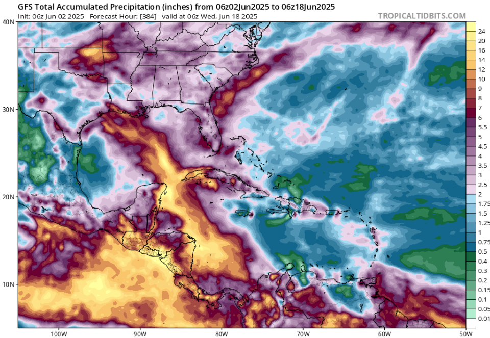
Accumulated Precipitation over the Region until 18. June 2025. Source: https://www.tropicaltidbits.com/analysis/models/?model=gfs®ion=watl&pkg=apcpn&runtime=2025060206&fh=384


