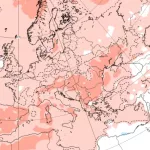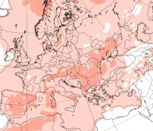
A rare summer cold wave is gripping Continental Europe, bringing a sharp drop in temperatures and raising the risk of flooding in several countries. From Monday to Wednesday (7–9 July 2025), an exceptionally cold air mass has settled over parts of Continental Europe, pushing daytime maximum temperatures down to just +8°C to +16°C in many regions—values more typical of late autumn than the heart of summer.
The unusual cold has been accompanied by heavy and persistent rainfall, particularly across the Alpine and Carpathian regions, creating dangerous flooding conditions in Northern Italy, Slovenia, Austria, Czechia, Southern and Central Poland, Bavaria, and Northern Slovakia. With saturated ground and swollen rivers, authorities in these areas are closely monitoring flash flood risks and issuing local alerts.
The Julian Alps, Eastern Alps, and Western Carpathians are seeing the heaviest accumulation due to orographic lifting, where moist air rises over mountains and cools rapidly, releasing precipitation.
The temperature drop has been extraordinary for July. In Germany, Austria, and the Czech Republic, many areas are seeing daily highs of only +10°C to +13°C, breaking records for coldest July days in decades. Mountainous areas such as the Tatras, Alps, and Šumava are experiencing conditions close to freezing, with snow possible at elevations above 1300 MALS, locally.
Meteorologists attribute this anomaly to a deep cyclonic trough descending from the North Atlantic, displacing the typical subtropical ridge that dominates European summer weather. Instead of heatwaves, much of Europe is under the influence of cold polar maritime air, intensified by a blocking high over Western Europe.
This sudden cold spell comes just days after parts of the region endured record-breaking heat, making the contrast even more striking. Agriculture, tourism, and transportation sectors may all be impacted, especially if localized flooding worsens or if cold stress damages crops.
Forecasts suggest a gradual return to near-normal temperatures by Thursday or Friday (July 10–11), but the next 48–72 hours remain critical for monitoring river levels, slope stability, and urban drainage systems, especially in flood-prone valleys.
Residents in affected countries are urged to follow updates from national meteorological and hydrological agencies, as the situation remains dynamic and potentially hazardous.


Source: wetterzentrale.de

Source: wxcharts.com


