Heatwave in Easternmost Europe: Almost +20°C at the Night near Polar Circle + Forecast from the Caucasian to Arkhanhelsk until 16. June 2025
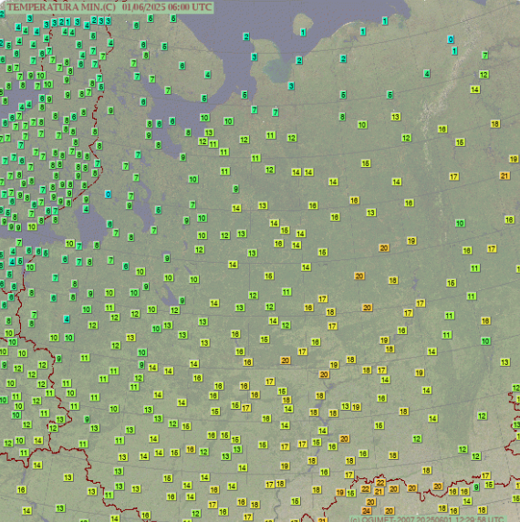
In recent days, the southern regions of Russia, especially the North Caucasus area, have experienced unusually high minimum temperatures that stand out as remarkable anomalies for this time of year. Normally, nighttime and early morning temperatures in these regions would be expected to cool significantly, often dropping to much lower levels as the atmosphere loses heat after sunset. However, data shows that locations such as Dosang recorded a minimum temperature of 22.0°C, and Gorodec did not cool below 20.1°C. These figures are striking because they indicate very little cooling overnight, a sign that warm air masses have dominated the region continuously, day and night.
What makes this phenomenon even more notable is that similar temperature anomalies have been recorded much further north, at latitudes as high as 65°N. At these high latitudes, one would typically expect cool nights due to the influence of seasonal sun angles and longer nights in spring. Yet, minimum temperatures in these areas have exceeded 19°C, signaling an extraordinary deviation from climatological norms. Such warmth this far north so early in the season suggests a broader atmospheric pattern of stagnant high pressure, which traps warm air masses and inhibits nocturnal cooling.
This sustained elevated minimum temperature pattern across such a broad latitudinal range highlights the influence of changing climate dynamics and persistent weather patterns. It points toward an increased frequency of warm nights, which can contribute to more intense and prolonged heatwaves. The combined effect of high daytime and nighttime temperatures is particularly stressful for agriculture, as crops rely on cooler nights for recovery and metabolic balance. Similarly, natural ecosystems face added strain, as plants and animals struggle to adapt to reduced temperature variability.
In summary, the exceptional nighttime warmth seen in southern Russia’s North Caucasus and extending into high northern latitudes is an indicator of unusual and potentially dangerous heat conditions.
GFS Temperature Forecast Summary (Min & Max °C)
Period: Today – June 16, 2025
| City | Min Temp Range (°C) | Max Temp Range (°C) | Notes on Trends |
|---|---|---|---|
| Yerevan | 15 – 21 | 30 – 38 | Steady warming, highs peaking near 37–38°C around June 12–14 |
| Tbilisi | 14 – 20 | 28 – 35 | Moderate warming, stable max around 33–35°C after June 10 |
| Baku | 18 – 23 | 29 – 36 | Hot and dry, highs steady near 34–36°C |
| Makhachkala | 19 – 22 | 32 – 38 | Persistent heatwave, max temps often above 35°C |
| Grozny | 18 – 21 | 33 – 37 | Warm nights and hot days continuing |
| Vladikavkaz | 16 – 20 | 29 – 34 | Slight cooling around June 13, but temps remain above norm |
| Rostov-on-Don | 15 – 19 | 30 – 35 | Stable warm period, no major cooling expected |
| Volgograd | 14 – 20 | 31 – 36 | Gradual increase, peak near 36°C by mid-June |
| Saratov | 13 – 18 | 28 – 34 | Slight warming trend, temps remain warm but not extreme |
| Nizhny Novgorod | 10 – 16 | 22 – 28 | Cooler than southern cities, moderate warmth expected |
| Kazan | 11 – 17 | 24 – 30 | Stable moderate temperatures |
| Perm | 9 – 15 | 21 – 27 | Mild warming, no heatwave conditions forecast |
| Yaroslavl | 8 – 14 | 20 – 26 | Slight warming trend |
| Vologda | 7 – 13 | 18 – 24 | Cool nights persist, warm days expected |
| Arkhangelsk | 4 – 10 | 14 – 20 | Coolest in the list, stable mild summer temps forecast |


