Hurricane Kiko in the eastern Pacific reached hurricane status on September 2, 2025, maintaining a compact but well-defined structure over the open ocean. As of 12:00 UTC, the storm was centered near 13.8°N, 128.1°W, far from land, with maximum sustained winds of 75 kt (86 mph / 139 km/h) and a minimum central pressure of 987 mb. This intensity places Kiko as a Category 1 hurricane on the Saffir–Simpson scale. Satellite imagery shows deep convection clustered tightly around the small eye feature, while the radius of maximum winds extends only about 10 nautical miles, indicating that this is a small but powerful storm.
The surrounding environment remains conducive to further strengthening in the short term. Warm sea surface temperatures near 28–29°C provide sufficient fuel, while vertical wind shear remains relatively weak. Outflow aloft appears established in multiple quadrants, suggesting that Kiko could intensify slightly in the coming day. However, as often occurs with small and compact cyclones, intensity changes may happen abruptly, and both rapid strengthening and sudden weakening are possible in short time spans.
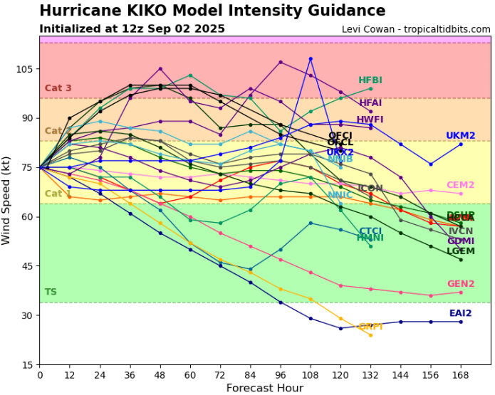
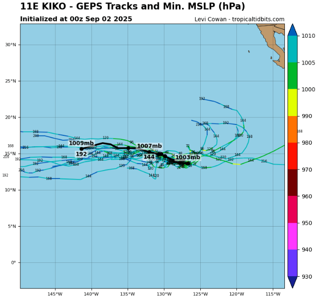
Forecast guidance suggests that Kiko will move toward the west-northwest over the next several days, steered by the subtropical ridge to its north. With this trajectory, the hurricane is expected to remain far away from the Mexican coastline and will not pose a direct threat to land. Models indicate the possibility of gradual intensification in the near term, potentially bringing Kiko close to Category 2 status, before environmental conditions become less favorable. By the latter part of the week, cooler waters and increasing shear could induce weakening.
Despite its remote position, Kiko remains a storm of significance to maritime interests in the eastern and central Pacific. Seas near the hurricane will be rough, and strong swells may propagate outward from the core circulation. The compact nature of the storm means that the strongest winds are confined to a small area around the eye, yet outer rainbands may still produce squalls affecting vessels in the region. Because of its small size, even modest changes in wind shear or ocean heat content could cause the system to fluctuate in intensity rapidly.
Kiko is part of the climatological peak of the eastern Pacific hurricane season, which typically occurs in late August and September. Historically, storms that form at these longitudes often remain over the open ocean and serve as case studies for tropical meteorology rather than direct hazards to populations. This hurricane illustrates the dynamics of compact cyclones, which are often harder to forecast in terms of both intensity and lifespan. The system also contributes to the seasonal activity statistics, reflecting the ongoing active pattern across the basin.
In summary, Hurricane Kiko is a compact but well-organized Category 1 hurricane with winds of 75 kt and a pressure of 987 mb. The storm is projected to remain over open waters, away from land, while possibly intensifying in the short term before weakening later in the week. Its evolution will be closely monitored by forecasters, as small hurricanes like Kiko often display rapid changes and provide valuable insight into tropical cyclone behavior.
Source: tropicaltidbits.com


