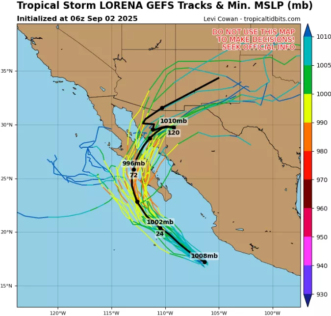
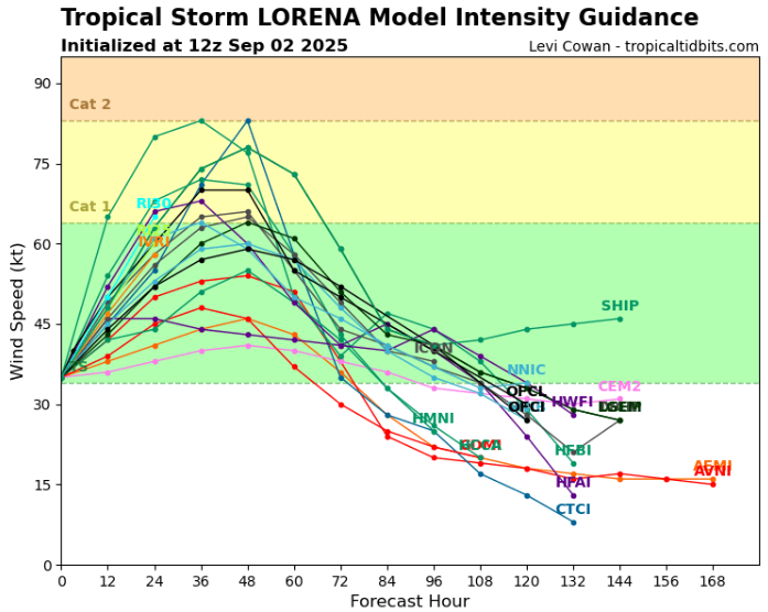
Tropical Cyclone Lorena is developing into a significant weather event in the eastern Pacific, threatening Mexico and eventually the southwestern United States. As of 12:00 UTC, September 2, 2025, the center of Lorena was located near 17.9°N, 107.4°W, with maximum sustained winds of 35 kt (40 mph / 65 km/h) and a minimum central pressure of 1005 mb. While currently classified as a tropical storm, forecasts indicate strengthening, with the potential to reach hurricane status before making landfall.
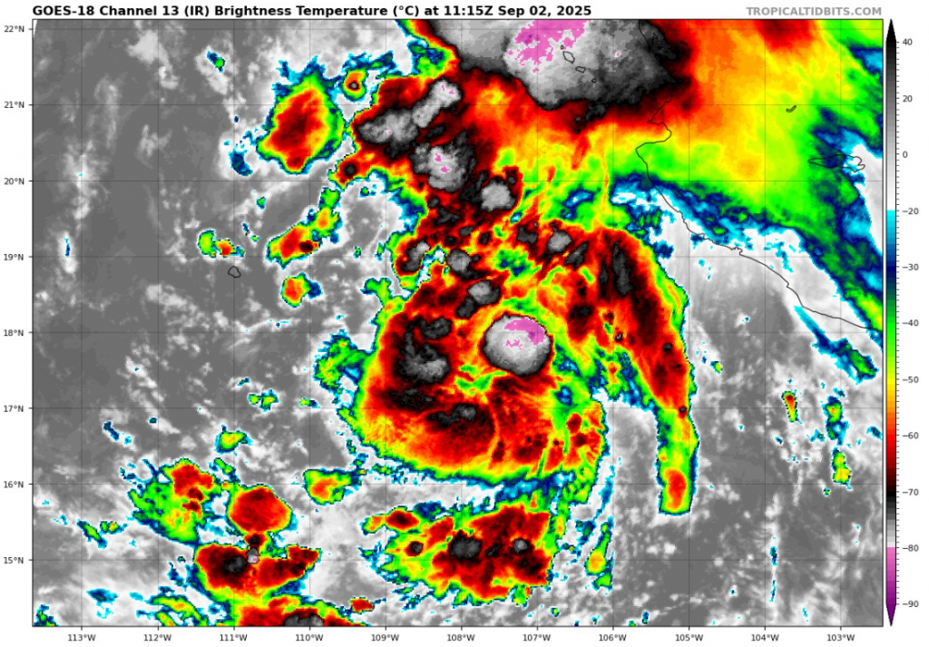
The storm’s radius of maximum winds extends to about 30 nautical miles, making it a broader system than some of the compact hurricanes seen earlier this season. Satellite imagery reveals persistent deep convection clustered around the circulation center, with expansive rainbands spiraling toward the Mexican coast. The structure suggests that Lorena is steadily organizing, aided by warm ocean waters and moderate wind shear that favors gradual intensification.
Lorena’s track brings it dangerously close to the Mexican states of Colima, Jalisco, and Nayarit, where heavy rainfall, flash flooding, and strong winds are expected within the next 24–48 hours. Rainfall totals in some mountainous regions could exceed 8–12 inches (200–300 mm), creating a serious risk of landslides and mudflows. Along the coastal areas, storm surge combined with large waves will lead to hazardous surf conditions and possible inundation of low-lying areas. As the system strengthens, hurricane-force winds may affect populated coastal zones, causing infrastructure damage and power outages.
After impacting western Mexico, Lorena is forecast to move northward into the Gulf of California. From there, the system could maintain enough intensity to bring tropical storm or hurricane conditions into the Baja California Peninsula, especially near La Paz and surrounding areas. Beyond Mexico, remnants of Lorena or its re-strengthened core may cross into the desert Southwest of the United States, particularly Arizona, New Mexico and Texas, delivering torrential rainfall and increasing the risk of flash floods. Even if Lorena weakens over land, its moisture plume will likely trigger widespread thunderstorms and dangerous flood events in vulnerable desert valleys and river basins.
The broader impacts of Lorena highlight the dual threats of wind and water. While the wind field is not as compact or intense as some previous hurricanes, its larger radius of circulation means that heavy rainbands and gusty winds will cover a wider area. This increases the number of communities affected by the storm. Maritime activity along the Pacific coast of Mexico is already being disrupted, with ports preparing for closures and fishing vessels moving to safety.
Climatologically, early September is one of the most active periods in the eastern Pacific hurricane season, and Lorena fits the pattern of storms that develop near Mexico and track inland. Unlike remote storms that stay at sea, Lorena is poised to deliver direct human impacts, from damaging winds to life-threatening flooding. The storm underscores the importance of preparedness, as even a system that begins as a tropical storm can quickly escalate in strength and produce serious consequences.
In summary, Tropical Storm Lorena is strengthening over the eastern Pacific with winds of 35 kt, a central pressure of 1005 mb, and a radius of maximum winds of 30 nm. Forecasts call for Lorena to reach hurricane strength, make landfall in western Mexico, and later influence the Baja Peninsula and the southwestern United States with heavy rain, flooding, and gusty winds. The storm is already prompting coastal alerts and will remain a major focus for forecasters and emergency agencies in the coming days.
Source: tropicaltidbits.com


