Newest GFS Runs Count with Heat Dome-like Heatwaves above Western Europe
As we approach mid-June 2025, the ongoing weather situation in Europe confirms the latest GFS model projections: the first significant heatwaves of the summer have primarily targeted Western European regions, while Central and Eastern parts of the continent should remain under the influence of relatively cooler and wetter conditions.
The heatwave episode, beginning in late May, has intensified across the Iberian Peninsula and parts of France, with temperatures soaring well above the seasonal average. Spain, in particular, has seen extreme highs—already exceeding 42°C in Andalusia and southern interior zones. Cities like Córdoba and Seville are experiencing unusually prolonged heat episodes, stretching into the second week of June. Portugal, too, is under intense thermal pressure, especially in the central-southern districts like Alentejo and the Tagus Valley, where daytime highs are pushing toward the 40°C mark.
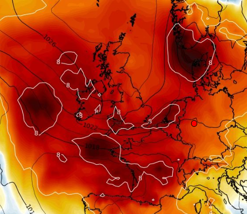
Southern France has followed a similar pattern, with temperatures climbing to 36–37°C in Occitanie and Provence. Even the Paris basin is now registering around 30°C, and further warming is expected as we move into mid-June. The influence of a persistent subtropical ridge over Western Europe—clearly visible in 850 hPa temperature charts—has resulted in dry, stagnant air masses and widespread heat alerts in parts of France and Spain.
Meanwhile, the British Isles have experienced a delayed transition to warmer weather. After an unusually chilly start to June, including reports of snowfall in parts of the Scottish Highlands, temperatures in the UK are now gradually climbing. Forecasts suggest that cities like London may reach 30-34°C around June 15–18, while parts of Scotland will likely remain cooler, but still with summer days in the peak (above +25°C).
In stark contrast, according the the newest outputs, Central Europe—including Germany, Austria, the Czech Republic, Slovakia, and Hungary—has largely escaped the initial wave of extreme heat. The Central European jet stream orientation and the lack of a sustained high-pressure block over the region have helped shield these areas from the Saharan heat plume engulfing the West.
Meteorological consensus, supported by both GFS and ECMWF ensemble runs, suggests that this east–west thermal contrast may persist into the third week of June. While Western Europe endures more heatwaves, Central and even Southeastern Europe may experience fluctuating temperatures, with only short-lived warm-ups followed by cooler breaks.
Looking ahead, long-range models hint at a potentially hotter July across much of Europe. But for now, it appears that the early summer heat will be more a Western affair. This westward focus matches earlier forecasts and underlines the increasing role of persistent atmospheric patterns in shaping Europe’s seasonal climate extremes.
Whether this is a taste of a more turbulent summer remains to be seen—but the signs, especially in the western half of the continent, are already intense and telling.

T850 hPa anomaly accroding to 06Z run of GFS from 4. June 2025 for 20. June 2025. Source: https://www.wxcharts.com/
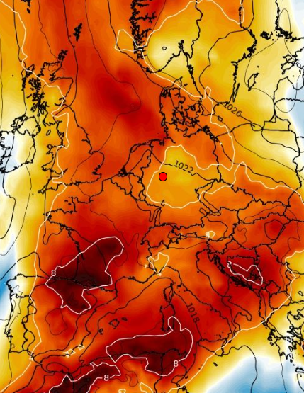
T850 hPa anomaly accroding to 06Z run of GFS from 4. June 2025 for 13. June 2025. Source: https://www.wxcharts.com/


