In early June 2025, Texas experienced a series of intense thunderstorms that brought with them some of the most severe weather phenomena seen this season. Widespread reports of gigantic hailstones, some exceeding the size of baseballs, coupled with multiple tornado touchdowns, have left communities scrambling and weather experts analyzing the dynamics behind these destructive storms.
Meteorological Setup
The severe weather outbreak in Texas was primarily driven by a potent clash between warm, moist air masses originating from the Gulf of Mexico and a strong upper-level trough advancing from the western United States. This configuration created a highly unstable atmospheric environment conducive to vigorous thunderstorm development.
Daytime surface temperatures across Texas soared into the upper 80s and low 90s Fahrenheit (around 31–34°C), while dew points lingered in the mid to upper 60s Fahrenheit (around 18–20°C). This combination ensured abundant moisture and buoyancy necessary for deep convective activity. Meanwhile, strong vertical wind shear — changes in wind speed and direction with height — provided the necessary rotation within storm cells, promoting supercell formation and subsequent tornado development.
Gigantic Hail: A Sign of Violent Updrafts
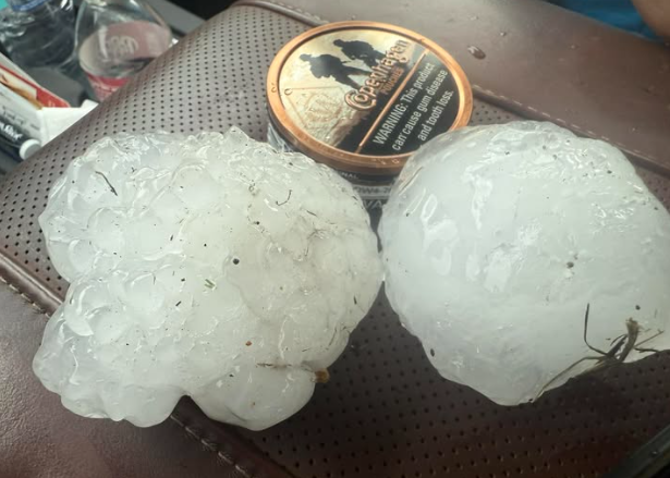
One of the most striking features of this storm event was the occurrence of gigantic hail, with some reports describing hailstones larger than 4 inches (10 cm) in diameter. Such enormous hail requires extremely strong and sustained updrafts within thunderstorms, often exceeding speeds of 100 mph (160 km/h). These updrafts suspend hailstones in the storm cloud long enough for them to accumulate multiple layers of ice before gravity eventually forces them to the ground.
Areas hardest hit by the hail included parts of Central and North Texas, with damage reported to vehicles, roofs, and agriculture. The impact of these hailstones not only poses a threat to property but also represents a hazard to livestock and residents caught outdoors.
Tornado Activity: Multiple Touchdowns Confirmed
Alongside the damaging hail, several tornadoes touched down in Texas during this severe weather episode. Radar data and ground surveys confirmed the presence of multiple tornadoes ranging from EF1 to EF3 in intensity. These tornadoes were often associated with supercell thunderstorms characterized by rotating mesocyclones.
The tornadoes caused varying degrees of damage, including uprooted trees, damaged structures, and downed power lines. The rapid development of these tornadoes underlined the importance of timely warnings and public preparedness.
Challenges for Forecasting and Warning Systems
Forecasting severe weather with large hail and tornadoes remains a challenge due to the complex interplay of atmospheric parameters required to produce these phenomena. Meteorologists rely heavily on advanced radar systems, satellite data, and computer models to anticipate storm development and evolution.
In this Texas outbreak, the Storm Prediction Center (SPC) issued multiple mesoscale convective watches and warnings as atmospheric conditions evolved. Local National Weather Service offices coordinated closely to provide real-time updates to the public, emphasizing the importance of heeding warnings and having safety plans in place.
Broader Climate Context
While isolated severe weather events like this are not uncommon in Texas, there is ongoing scientific discussion about the potential influence of climate change on the frequency and intensity of such storms. Warmer temperatures can increase atmospheric moisture content, potentially fueling more powerful storms. However, changes in wind shear patterns are complex and regionally variable, meaning future trends in tornado and hailstorm activity require continued research.
Conclusion
The June 2025 storms in Texas serve as a vivid reminder of the power of nature’s severe weather. Gigantic hailstones and tornado touchdowns caused significant damage, tested emergency response capabilities, and highlighted the need for continued advances in meteorological forecasting and public awareness. As summer progresses, vigilance remains crucial for residents in tornado-prone and hail-prone regions of Texas and beyond.
Copengahen, Texas, 9. June 2025. Source: https://www.facebook.com/DougWarner.Journalist/posts/yes-a-can-of-copenhagen-is-an-official-measuring-device-for-monster-hail-this-wa/1271428324342975/

Lubbock, Texas, 26. May 2025. Source: https://www.facebook.com/JohnCarlosEstradaCBSAustin/posts/hail-insanity-near-lubbock-afton-texas-got-slammed-with-cantaloupe-sized-hail-ye/1264848271881056/


