Severe Flooding in Western Australia and the Northern Territory: A Historic May 2025
May 2025 has brought unprecedented rainfall to Western Australia and the Northern Territory, resulting in record-breaking floods and significant disruptions across the regions.
Western Australia: Record Rainfall and Widespread Flooding
A massive northwest cloud band, fueled by tropical moisture from the Indian Ocean, has delivered exceptional rainfall to parts of Western Australia. Broome recorded its heaviest May rainfall in 20 years, with 100.6mm falling within 24 hours. Tindal, near Katherine in the Northern Territory, received nearly 180mm in just one day, a stark contrast to its typical May average of 2mm .
These intense downpours have overwhelmed drainage systems, leading to flash flooding in several towns. The Bureau of Meteorology has issued flood watches for the West Kimberley and Fitzroy Rivers, as well as the Desert catchments in Western Australia, due to the persistent heavy rainfall
Northern Territory: Unseasonal Deluge and Agricultural Impact
The Northern Territory has experienced similarly extreme weather. Katherine recorded 179mm of rain in 24 hours, surpassing its previous May record of 61mm set in 1915. Other areas, such as Tennant Creek and Birrindudu cattle station, also reported significant rainfall, leading to localized flooding and road closures.
Farmers in the region are facing challenges as the unseasonal rains have affected crops and livestock. While some cattle producers welcome the moisture, melon growers have reported issues with waterlogged fields.
16-Day GFS Forecast Outlook for Australia
The Global Forecast System (GFS) model indicates that the active weather pattern will continue across Australia over the next 16 days.
- June 1–5, 2025: The GFS model predicts a continuation of the northwest cloud band, bringing additional heavy rainfall to Western Australia and the Northern Territory. Areas already affected may experience further flooding, and the Bureau of Meteorology has advised residents to remain vigilant and prepared for potential impacts .
- June 6–10, 2025: A brief respite is expected as a high-pressure system moves over southern Australia, leading to drier conditions in the affected regions. However, this period of stability is likely to be short-lived, and residents should remain alert to changing conditions.
- June 11–16, 2025: The GFS model suggests the possibility of another low-pressure system developing, which could bring renewed rainfall and potential flooding to parts of Western Australia and the Northern Territory. Residents should monitor updates from the Bureau of Meteorology and be prepared for rapidly changing weather conditions.
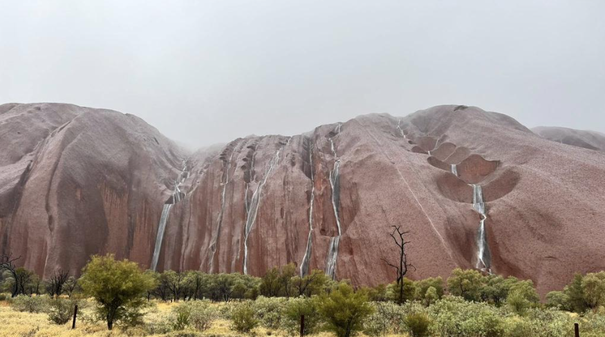
Uluru rock after heavy storms. Source: https://www.news.com.au


