
⚠️ Severe Thunderstorm Threat – Today & Tonight
- Scattered severe storms are expected across central/eastern Montana, northeast Wyoming, and the western Dakotas. These storms may bring large to very large hail (up to 2+ inches) and damaging wind gusts, potentially exceeding 75 mph.
- Scattered convection may also form in the central/southern High Plains and move eastward, possibly producing supercells with hail and gusty winds.
🔍 SPC Day 2 Outlook (June 16)
- An enhanced risk (Level 3/5) is in effect for parts of eastern South Dakota and Minnesota, extending into northwest Wisconsin, driven by:
- A shortwave trough diving across the Dakotas,
- A southward-moving cold front, and
- A moist, unstable air mass creating MLCAPE of 3000–4000 J/kg and ample directional shear.
- Storms may initiate near the front late morning, tracking into central/northern Minnesota during the afternoon with isolated severe potential
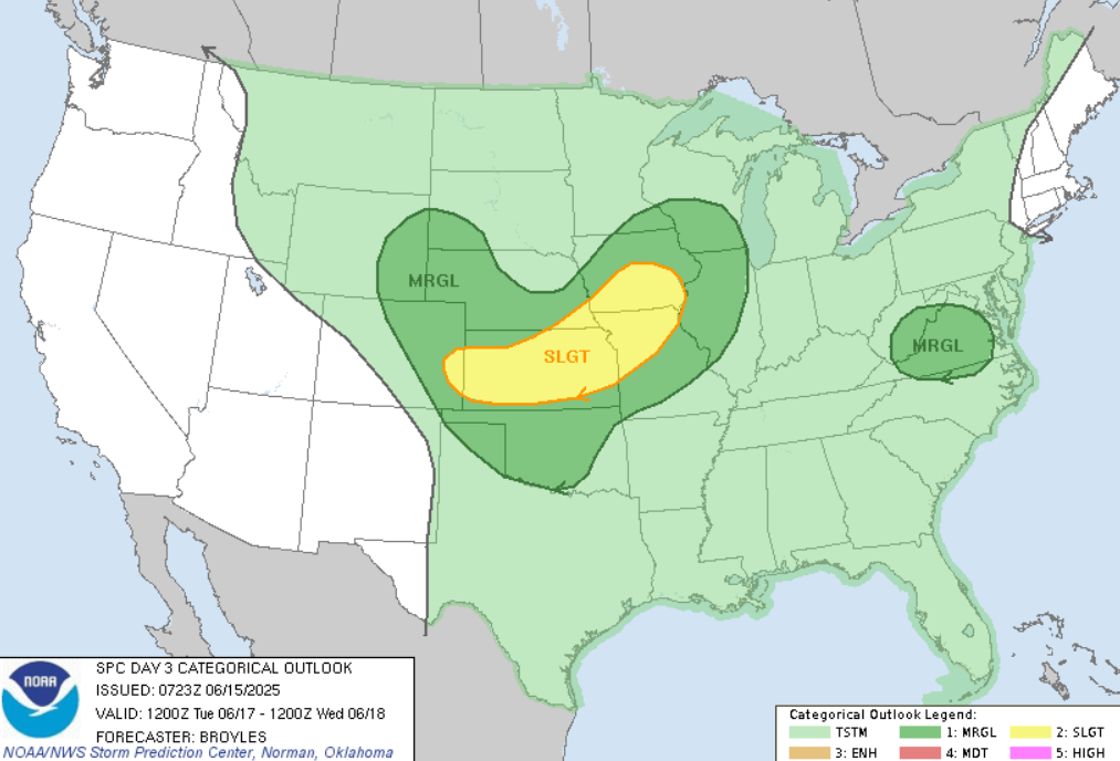
⏳ SPC Day 3 Outlook (June 17)
- Slight risk (Level 2/5) remains for parts of the Central Plains and Missouri Valley, focusing on:
- A fast-moving trough over the Rockies, and
- A southward-advancing cold front.
- Conditions support large hail and damaging winds, with MLCAPE of 4000–5000 J/kg and moderate deep-layer shear—favoring supercell development early, followed by upscale storm modes
🌩️ Regional Highlights & Timing
| Region | Timing | Hazards |
|---|---|---|
| MT, WY, Dakotas | Today–Tonight | Large hail (2″+), 75+ mph wind gusts |
| SD → MN → WI | Monday midday–eve | Isolated severe storms along cold front |
| Central Plains | Tuesday | Supercells producing hail & gusty winds |
❗ Key Impacts & Precautions
- Large hail may shatter windows, damage crops, and impact vehicles.
- Severe wind gusts can bring down trees, power lines, and cause structural damage.
- Localized flash flooding possible in heavy rainfall cores.
- Stay weather-aware today and tomorrow: monitor local forecasts, secure outdoor items, and have a safety plan ready.
📅 Longer-Term Outlook (Days 4–5)
- A mid-level trough is forecast to shift through the Upper Midwest, prompting additional clusters of severe storms in the Great Lakes and Ohio Valley Wednesday and Thursday
- Days 6–8 show lower confidence, though isolated severe thunderstorm potential remains possible.
🧭 Final Takeaway
A multi-day window of severe weather is unfolding:
- Today: hail and damaging winds across Montana, Wyoming, Dakota region.
- Monday: heightened severe risk in SD, MN, WI, including isolated supercells.
- Tuesday: continued concerns in the Central Plains and Missouri Valley.
- Midweek: secondary chances for severe storms in the Upper Midwest and Great Lakes.
💡 Be prepared: ahead of storms, check radar, charge devices, and secure any vulnerable property. This heat of activity demands heightened vigilance for safety.

Source: https://www.spc.noaa.gov/products/outlook/day3otlk.html


