Snow Showers in Eastern Carpathians above only 1000 MASL in Summer not Totally Excluded

Eastern Carpathians, June 2025 – While the calendar says summer, the mountains may still speak the language of winter. A recent trend in high-altitude meteorological models suggests that snow showers above 1,000 meters above sea level (MASL) in the Eastern Carpathians are not entirely out of the question in the coming days.
📉 Model Signals: A Marginal but Present Cold Intrusion
Latest runs of the GFS (Global Forecast System) indicate 850 hPa temperatures dipping close to or slightly below 0 °C over portions of the Eastern Carpathians during the extended forecast period (particularly around June 12–13 and again after June 20). Although most of the air mass remains marginal for snowfall, isolated below 0°C 850 hPa are projected — sufficient to bring wet snow or graupel to exposed ridges or upper forest zones.
🌨️ Ground-Level Reality: High Elevation, Light Accumulation
While deep snow cover is unlikely, brief snow flurries or sleet showers at elevations just above 1,000 m, especially during nighttime cooling, are not out of the realm of possibility — particularly in northern Romania (Rodna, Călimani Mountains), eastern Slovakia (Vihorlat, Bukovské vrchy) and Hoverla region, Ukraine. Snow showers are expected in High Tatra Mountains in Slovakia, but above 1300-1500 MASL from June 12th to June 13th (Thursday to Friday).
These events are expected to be:
- Local, likely confined to north-facing slopes,
- Short-lived, with snow melting within hours,
- And mixed with rain in many cases.
🧭 Climatological Context: Not Unprecedented
Late-season snow showers above 1,000 m in the Eastern Carpathians have been historically observed into mid or even late June, especially during anomalously cool spells. While climate change has shifted the norm, microclimatic zones in high valleys and saddle regions continue to defy averages on occasion.
🌨️ Snow at +5 °C? Wind Makes It Possible
Although surface temperatures are expected to hover near +5 °C at high elevations, snow showers are still possible due to:
- Strong upslope winds, which can cool the local air mass through adiabatic processes,
- Moisture influx, and
- The presence of colder layers aloft, especially around 850 hPa (~1,500 m)
🧊 Lviv: Near-Record Cold in the Lowlands
The cold anomaly isn’t limited to mountaintops. Forecasts show that Lviv, in western Ukraine, could experience temperatures as low as +2 °C in the early mornings during the coldest phase.
This would place the city a mere:
- 1.5 °C above the all-time June record low,
- –3 °C should be taken from +5°C forecast
The GFS model clearly shows this dip, suggesting a remarkably cold air mass by June standards, especially across Eastern Slovakia, Western Ukraine, and Northern Romania.
🌐 Outlook and Monitoring
The probability of measurable snow remains low, but:
- Mountain hikers should prepare for rapid weather changes.
- Weather enthusiasts may track this event via high-resolution satellite and webcam feeds.
- Further GFS runs will clarify whether this remains a weak signal or grows into a more pronounced anomaly.
🧊 Conclusion: Watchful Eyes on the Peaks
Snow in summer? Not typical — but in the twilight zone of the high Eastern Carpathians, cold air can still stage a return, however brief. With atmospheric conditions in flux, the next few days may offer a rare seasonal juxtaposition: lush June valleys beneath fleeting white summits.
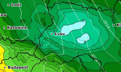
T850 hPa on Friday, June 13th 6:00. Source: https://www.wxcharts.com/?panel=default&model=gfs,gfs,gfs,gfs®ion=seeurope&chart=850temp,850temp,wind10mkph,snowdepth&run=00&step=054&plottype=10&lat=51.257&lon=8.418&skewtstep=0
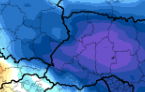
T850hPa Anomaly on Friday, June 13th 6:00.
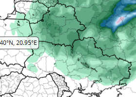
Showers on the Back Side of Low Pressure System above Eastern Europe on June 13th 2025. Source: https://www.tropicaltidbits.com/analysis/models/?model=gfs®ion=eu&pkg=apcpn24&runtime=2025061100&fh=72
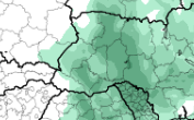
Accumulated 24-hour Precipitation 6 Hours Later. Source: https://www.tropicaltidbits.com/analysis/models/?model=gfs®ion=eu&pkg=apcpn24&runtime=2025061100&fh=102
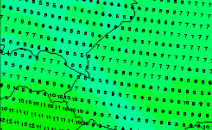
Temperatures on Friday 13th at 6:00 above Eastern Carpathians. Source: https://www.wetterzentrale.de/en/topkarten.php?map=38&model=gfs&var=48&run=6&time=48&lid=OP&h=0&mv=0&tr=1#mapref
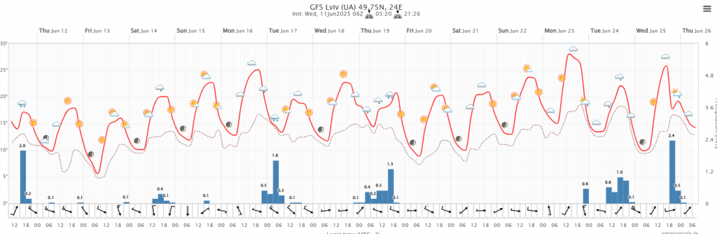
Source: https://www.wetterzentrale.de/en/show_diagrams.php?model=gfs&lid=OP&var=93&geoid=119654


