The 1st Tropical storm of the season – Alvin near Mexico, tropical wave in the Caribbean, extreme hail in Texas, extreme temperatures in Northwest Territories, wildfires in Central Canada, forecast for Heat dome from Mexico to Western USA and Canada, storm forecast for Central and Eastern USA
As North America approaches the midpoint of 2025, the continent is grappling with a convergence of extreme weather events that span coast to coast and reach deep into the Arctic Circle. From the formation of the first named tropical storm in the Eastern Pacific to record-breaking heat in Canada’s Northwest Territories, this early summer period is a potent reminder of our atmosphere’s growing volatility.
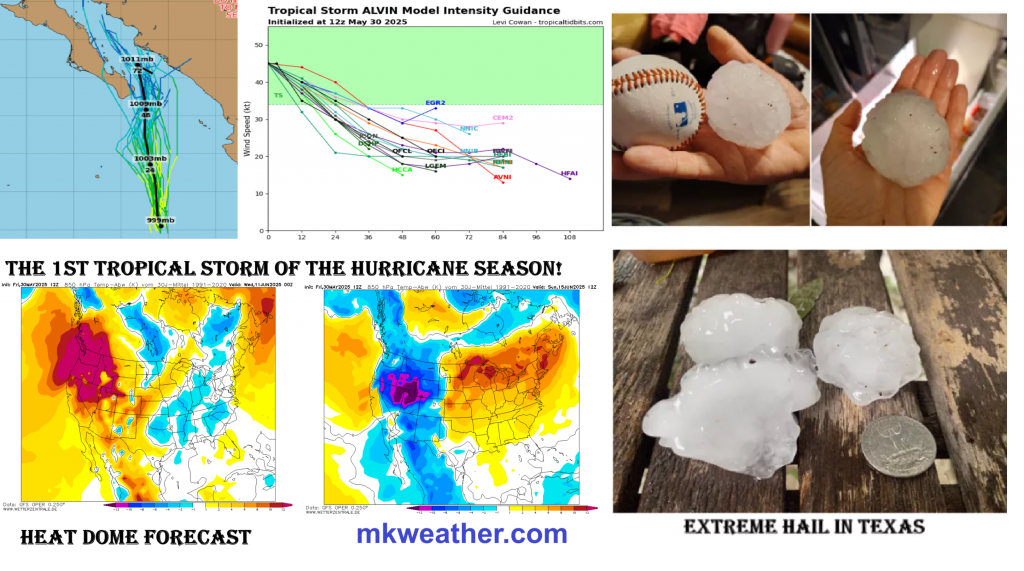
Tropical Storm Alvin, the first named storm of the 2025 Pacific hurricane season, formed several hundred miles south of the Baja California Peninsula. Though not expected to make landfall, Alvin has been lashing Mexico’s west coast with intense rain and powerful surf. States like Jalisco and Michoacán are already experiencing localized flooding and beach erosion. While Alvin is projected to weaken as it drifts into cooler waters, its residual moisture may contribute to storm development farther inland or along the southern U.S. border.
Meanwhile, in the Caribbean Sea, a tropical wave is slowly gaining organization. Though not yet a named system, the disturbance brings scattered thunderstorms and the potential for development as it tracks westward. Such early-season activity is a warning sign of an active hurricane season to come.
At the same time, severe storms have hammered Texas. In Austin, baseball-sized hail—some nearly six inches in diameter—smashed windows, damaged vehicles, and even tore holes in stadium structures. San Antonio saw flash floods that turned roadways into rivers, prompting emergency rescues and infrastructure damage. May’s combination of hot, moist air and advancing frontal boundaries has made Texas a storm hotspot.
To the north, wildfires are rapidly spreading across the Canadian Prairies. In Manitoba and Saskatchewan, over 200,000 hectares have already burned, forcing tens of thousands to evacuate. Smoke from these fires is drifting southward, degrading air quality across the Midwest and reaching as far as the Eastern Seaboard of the United States. Public health officials warn of hazardous conditions, particularly for those with respiratory issues.
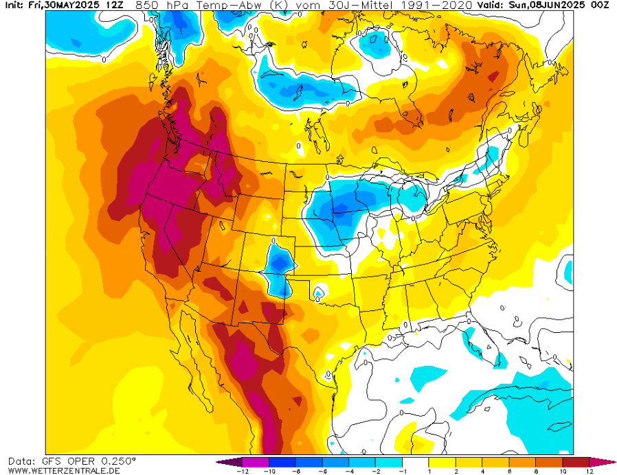
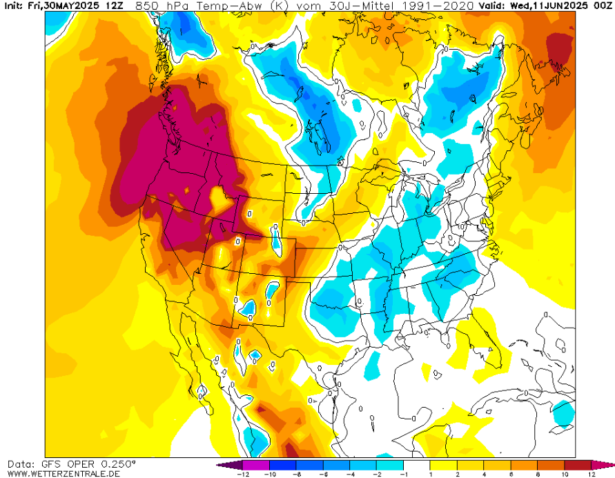
Perhaps the most dramatic weather anomaly this month is the expansive and persistent heat dome stretching from central Mexico through the southwestern U.S. into Canada’s interior. Under its oppressive grip, daytime highs have soared to staggering levels: 115°F (46°C) in parts of northern Mexico, 112°F (44°C) in Texas, and even 100°F (38°C) in northern Minnesota. The Northwest Territories, better known for subarctic chill, saw an astonishing +34,3°C (93.7°F) in Hay River—a temperature more typical of Arizona than the Arctic Circle.
Meteorologists attribute this anomaly to a stalled high-pressure ridge in the upper atmosphere, which traps heat over large areas. Combined with early-season drought conditions and wind patterns, this heat dome not only elevates fire risk but also places enormous strain on power grids, water systems, and public health infrastructure.
As this ridge holds, Central and Eastern U.S. states are also bracing for severe convective storms. Forecasts for the Midwest to the Northeast suggest a parade of thunderstorms, some capable of producing damaging winds, large hail, and flash flooding. In cities like New York and Boston, humid air and unstable conditions are expected to produce locally intense downpours, potentially disrupting travel and flooding low-lying urban areas.
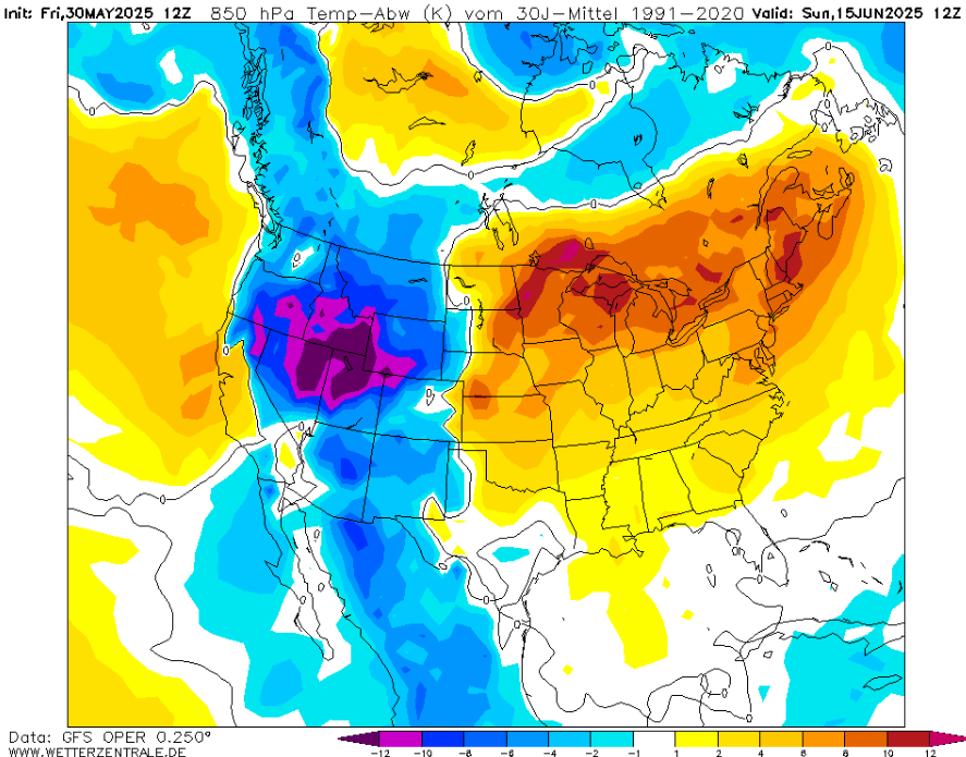
Looking ahead, long-range models suggest no immediate end to this volatile pattern. The heat dome may shift eastward but shows signs of persistence into June. Combined with continued dry conditions in Western Canada and increasing sea surface temperatures in the tropics, the North American summer is setting up to be both historically hot and highly unstable.
More reading:
The severe weather threat will shift east Friday to include the Southeast and mid-Atlantic. /https://weather.com/storms/severe/video/severe-storms-friday-southeast-mid-atlantic-0/
Tornadoes, Softball Sized Hail Pounds Texas /https://weather.com/storms/severe/video/storms-tornado-giant-hail-hit-texas-big-country/.
EF1 Tornado kills 1 person in Kentucky early Friday morning /https://www.accuweather.com/en/weather-news/tornado-kills-1-person-in-kentucky-early-friday-morning/1780145/.
Smoke to pour into the US as Canada wildfires force province’s largest evacuation in ‘living memory’ /https://www.accuweather.com/en/weather-news/smoke-to-pour-into-the-us-as-canada-wildfires-force-provinces-largest-evacuation-in-living-memory/1780027/.
Tropical storm Alvin, first of 2025 season, forms in eastern Pacific /https://www.accuweather.com/en/hurricane/tropical-storm-alvin-first-of-2025-season-forms-in-eastern-pacific/1779175/.
Eyes on the southwest Atlantic for early-June tropical development /https://www.accuweather.com/en/hurricane/eyes-on-the-southwest-atlantic-for-early-june-tropical-development/1778721/.
Severe storms may cut power, hinder travel in eastern US at week’s end /https://www.accuweather.com/en/severe-weather/severe-storms-may-cut-power-hinder-travel-in-eastern-us-at-weeks-end/1779522/.
May ranks among the wettest ever in much of eastern, southern US /https://www.accuweather.com/en/weather-forecasts/may-ranks-among-the-wettest-ever-in-much-of-eastern-southern-us/1779297/.
TROPICAL STORM ALVIN
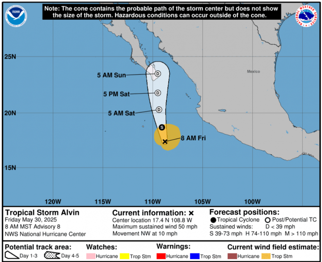
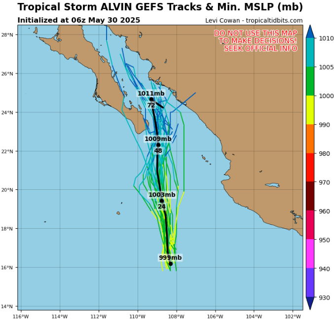
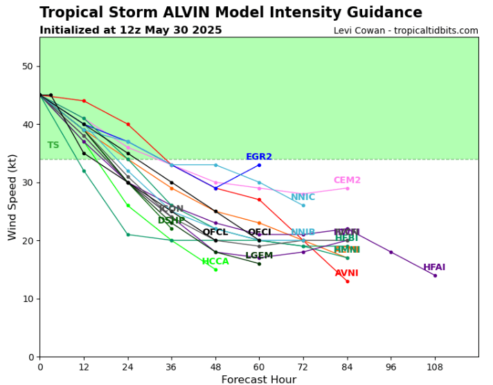
Source: https://www.tropicaltidbits.com/storminfo/#01E
A HEAT DOME FOR MEXICO, WESTERN USA AND CANADA AROUND 8. -12 JUNE 2025 AND SUBSEQUENT COOLDOWN
HISTORIC +34,3°C IN NORTHWEST TERRITORIES, CANADA


