Tropical Storm Chantal should hit the SE Coast, U.S. over the Coming Days!
As of early July 3, 2025, meteorologists are closely monitoring a weak area of low pressure forecast to develop near the Southeast Atlantic coast this weekend. This system currently holds a medium chance (about 60%) of developing into a subtropical or tropical depression as it drifts northward and northeastward over the coming days.
Current Situation and Forecast
The National Hurricane Center (NHC) and other weather agencies have highlighted this disturbance, which is expected to form along a weakening frontal boundary near Florida or the Southeast U.S. coast by Friday or Saturday. Despite the current disorganized appearance, conditions are marginally favorable for slow development. This potential system, which could be named Tropical Storm Chantal if it strengthens sufficiently, poses mostly a heavy rainfall threat rather than strong winds at this time.
StormHQ, a respected weather analysis group, noted that while the system looks disorganized, the chance of tropical or subtropical development is increasing, with probabilities now near 60%. The disturbance is expected to bring continued heavy rain across parts of the Southeast U.S. coast, especially near west-central Florida initially, with rain shifting toward the East Coast and the Mid-Atlantic states over the next several days.
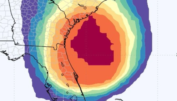
Rainfall and Impact Expectations
Forecasters expect that the heaviest rainfall will likely remain just offshore, but localized downpours and flooding cannot be ruled out in coastal and near-coastal areas. Heavy rain has been the primary impact so far, and it is expected to continue through early next week. Flooding concerns will mainly focus on urban areas and low-lying regions prone to water accumulation.
The system is not forecast to strengthen rapidly. Environmental factors such as sea surface temperatures and wind shear remain only marginally supportive of development, and any intensification is expected to be slow and limited.
Track and Movement
The disturbance is forecast to move slowly northward or northeastward along the Southeast coast, influenced by an upper-level low currently situated over the region. This upper-level low is expected to shift eastward in the next 24 to 36 hours, potentially allowing for gradual tropical or subtropical development once the system moves over the Atlantic Ocean.
Model guidance from the European Ensemble system suggests a high chance (over 90%) of some form of tropical or subtropical cyclone development along the Southeast or Florida East Coast within the next several days. However, even if a tropical depression or storm forms, it is likely to remain weak and primarily a “rain maker” rather than a wind threat.
Regional Implications
- Florida: Heavy rainfall is expected to continue along the west-central coast of Florida, shifting eastward toward the peninsula over the next few days. Flooding in some low-lying areas is possible.
- Southeast U.S. Coast: As the system moves northward, coastal areas from Georgia to the Carolinas and into the Mid-Atlantic could experience increased rainfall, localized flooding, and gusty winds.
- Gulf of Mexico: The chance of tropical development in the Gulf has decreased to near zero over the next several days, focusing attention on the Atlantic side.
What to Watch For
Residents in the Southeast and Mid-Atlantic coastal regions should monitor local weather updates and be prepared for periods of heavy rain and possible flooding. While the system is not expected to bring strong winds or a major storm event, localized flooding can impact transportation and daily life.
Forecasters will continue to track the system’s organization and intensity, updating probabilities and forecasts as new data becomes available over the weekend and into early next week.
Sources
- National Hurricane Center Tropical Weather Outlook, July 3, 2025
- StormHQ Weather Updates, July 3, 2025
- European Ensemble Model Forecasts
- Local National Weather Service Offices across Southeast U.S.
Source: https://x.com/WeatherProf/status/1940824792522805740/photo/1


