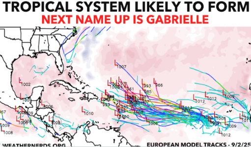
Tropical Storm Gabrielle is being monitored by forecasters as a possible tropical cyclone development over the next week. While the system has not yet formed into a named storm, environmental conditions in the tropical Atlantic basin are becoming increasingly favorable for cyclogenesis.
As of early September 2025, sea surface temperatures (SSTs) in the likely development region are above 28°C, providing sufficient heat energy to sustain deep convection. Vertical wind shear is forecast to be moderate to low over much of the area, which would allow a nascent disturbance to organize and intensify. Additionally, the presence of ample atmospheric moisture supports the potential for sustained thunderstorm activity that could consolidate around a developing low-pressure center.
Forecast models indicate a window of 3–7 days during which a tropical depression could form and potentially strengthen into Tropical Storm Gabrielle, depending on environmental interactions such as dry air intrusion or short-lived increases in shear. Should the storm materialize, it would likely follow a west-northwest track guided by the subtropical ridge, though early guidance suggests the system would remain over open waters initially, minimizing immediate land threats.
Forecasters are also monitoring the potential for rapid intensification once the storm consolidates, as the warm oceanic heat content is sufficient to support Category 1 hurricane strength, if other conditions remain favorable. However, due to uncertainties in early development, intensity forecasts remain highly variable at this stage.
In summary, Tropical Storm Gabrielle could form over the next week, with sea surface temperatures, low wind shear, and abundant moisture providing the ingredients for tropical cyclone development. While land impact is currently uncertain, the system warrants close monitoring for both maritime hazards and potential intensification.
Illustration map: weathernerds.org