Typhoon Wipha Nears Hong Kong: T10 Warning Issued, Flights Grounded and Ports Closed
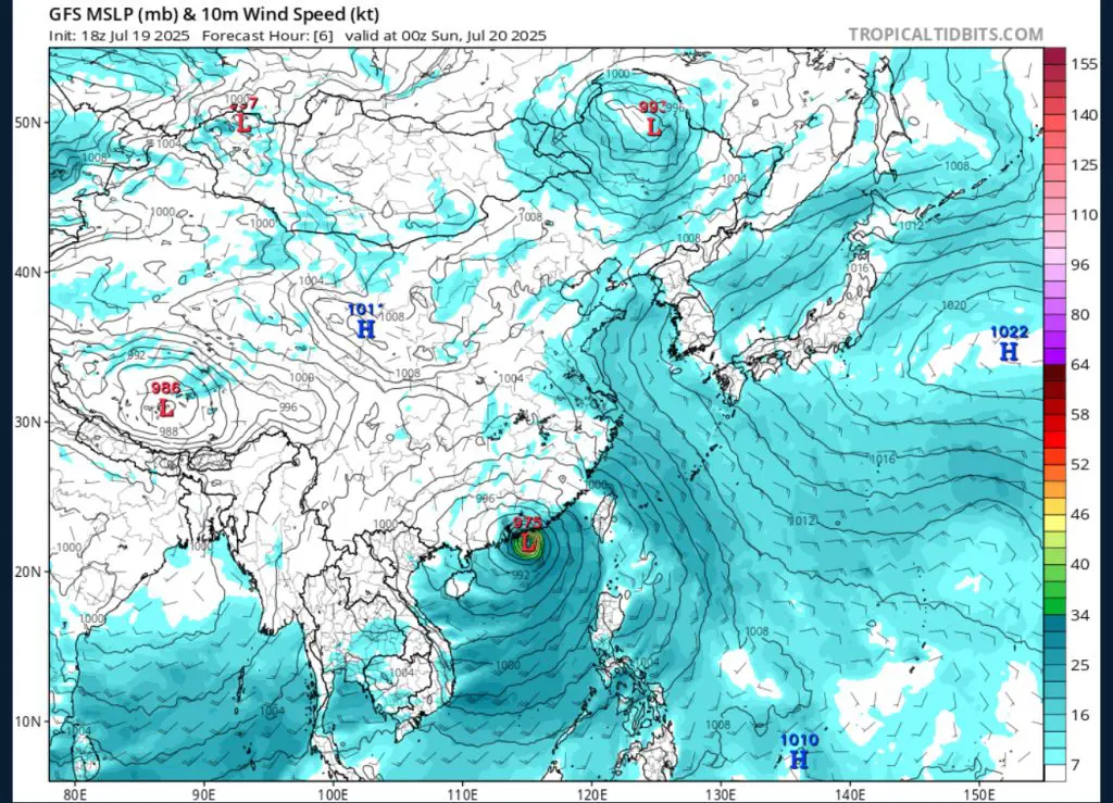
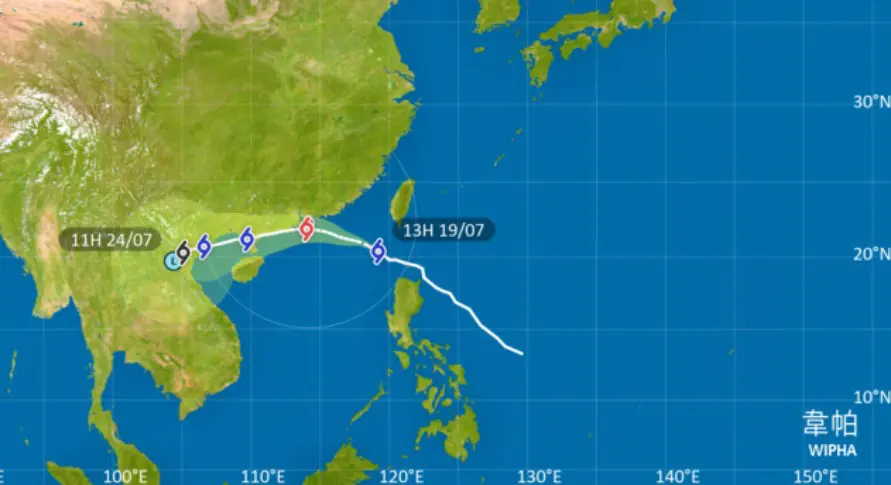
Typhoon Wipha formed in the Philippine Sea and moved northwest, passing south of Taiwan before entering the South China Sea as of July 19th. It strengthened into a typhoon overnight and now sits roughly 206 km (128 mi) east-southeast of Hong Kong, tracking west-northwest at about 31 km/h (17 knots). The Hong Kong Observatory raised the T9 storm signal early on July 20th and then escalated to the T10 warning, indicating the arrival of hurricane-force winds averaging ≥118 km/h (≥73 mph) . Forecasts show the typhoon’s eye may pass within 50 km (31 mi) south of the city by midday, bringing the fiercest conditions through the afternoon.
All flight operations at Hong Kong International Airport were halted between 05:00 and 18:00 HKT, with Cathay Pacific canceling or delaying over 500 flights. The Hong Kong–Macao Bridge was closed, and regional ports paused marine traffic as storm surges and high tides threatened coastal zones. Ferries and recreational boats have remained docked since Saturday evening, and marine forecasts warn of waves exceeding 8 m (27 ft) offshore. Land transport has also been affected: city buses, outdoor tram services, and select MTR lines are suspended or operating partially due to high wind warnings.
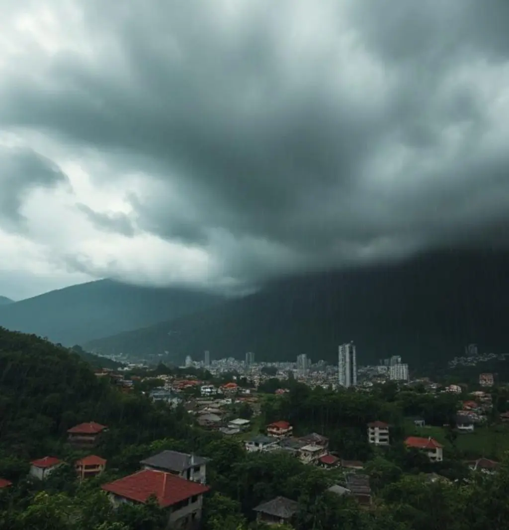
Authorities expect peak winds and rainfall during the midday to late afternoon hours of July 20th. Coastal waters rose to nearly 3 m (10 ft) above Chart Datum at Tai Po Kau, and maximum gusts of 103 km/h (64 mph) have already been recorded at Tate’s Cairn. Heavy squally showers are pounding urban districts, prompting the Observatory to open 34 temporary shelters, housing around 214 evacuees so far. With winds anticipated to reach hurricane strength, the risk to unreinforced structures, power lines, and coastal erosion is high, and the city is under full weather defensive postures.
The government has taken several proactive measures: all schools and non-essential public services are closed, emergency shelters opened, and residents urged to stay indoors and away from windows. The Observatory enhanced radar updates (now every 6 minutes) through its “MyObservatory” app to provide real‑time tracking. Authorities are deploying cleanup crews, pre-positioning ambulances, and inspecting vulnerable infrastructure—including sea walls, drainage systems, and hillside barriers. Power companies are on standby to respond to outages caused by fallen trees and blown debris, with high-rise and low-lying areas under particular scrutiny.
This year has seen a notably active Pacific typhoon season, with six storms already named, including Wutip and Danas, and Wipha as the sixth major system. Climatologists warn that warm sea surface temperatures, coupled with a possible La Niña, are fueling stronger and more frequent storms. Historically, Hong Kong has endured direct typhoon landfalls—most catastrophically in 1937, which resulted in over 11,000 fatalities near the city. With climate change expected to increase extreme weather events such as higher wind and rainfall intensities, the city may face more powerful storm impacts in coming decades. The experience with Wipha underscores the urgent need for improved preparedness and resilient infrastructure as typhoon patterns evolve.
Economists and insurers are already estimating losses. With high winds expected to damage rooftops, roadside lighting, and coastal installations, insured damages are forecast in the $200 million–$300 million USD range, with uninsured losses adding to the toll. Marine cargo delays and port closures—especially at Haikou, Hainan—add to the economic strain. Although wind speeds are the main threat, inland rainfall over southern China is expected to generate localized flooding—a recurring issue in typhoon seasons.