UK hit Severe Storms with Floods (30-80 mm) and 100,000 Lightning Strikes after the Hottest Day of the Year (Suffolk, +29,4°C), so far
The United Kingdom was rocked by a burst of severe thunderstorms over the weekend, delivering intense rainfall, flash flooding, and more than 100,000 lightning strikes—one of the most electrically active storm events of 2025 so far.
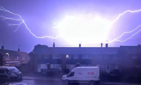
🌩️ Lightning on an Unprecedented Scale
- Over 100,000 lightning strikes were recorded in just over 24 hours, primarily across the UK’s coastal and offshore areas, according to the Met Office
- UK-wide networks confirmed that the vast majority of these strikes were over the sea, but some discharged over land, causing fires such as one in St Leonards-on-Sea
🌧️ Torrential Rain & Flash Flooding
- Some regions recorded 30–80 mm of rainfall in just hours, leading to widespread flooding across Scotland, South West England, and the Midlands .
- Urban centers such as Kent, Dover, and Plymouth saw waterlogged roads and inundated properties, and Exeter–Okehampton rail services were interrupted by a landslip
🚨 Warnings, Disruptions & Public Safety
- The Met Office issued multiple thunderstorm warnings—including amber and yellow alerts—across England, Wales, and Scotland
- Rail services were disrupted, flights delayed (especially at Heathrow), and road travel hampered by deep floodwaters. Emergency and utility services responded to power cuts, “spray” affecting visibility, and hail damage .
🩺 Health & Infrastructure Impacts
- The Health Security Agency issued its first heat-health alert of the year, as the country transitioned from a record June heatwave—29.4°C in Suffolk—to this violent storm outbreak
- Authorities emphasized the danger of driving through floodwaters, citing that just 30 cm of flowing water can displace a vehicle and urged the public to avoid flooded routes
STORMS CAME FROM NORMANDY…
Illustration picture: https://x.com/davebucca/status/1933822168649072883/photo/1


