

Europe
The start of May 2025 brought a historic snowfall in Moscow and tropical heatwave, such as a transition of powerful cold front trough Europe /https://mkweather.com/daily-weather-report-for-5-may-2025-coldwave-in-europe-will-last-long-2-weeks-bringing-snow-and-frosts-sweden-105c-finland-104c-the-uk-29c-poland-17c-the-netherlands-14c-denmark-13c-baltic-countries-1; https://mkweather.com/weather-report-04-05-2025/; https://mkweather.com/weather-report-for-may-3rd-2025-unseasonal-heat-in-central-continental-europe-30c-in-austria-and-hungary-high-temps-along-mid-atlantic-us-seaboard-31c-in-virginia-and-maryland-midd/; https://mkweather.com/weather-report-for-1-may-2025-continental-europe-after-tropical-heatwave-frosts-and-snow-in-basins-finland-102c-the-netherlands-295c-germany-288c-severe-storms-hit-easter//.
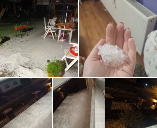
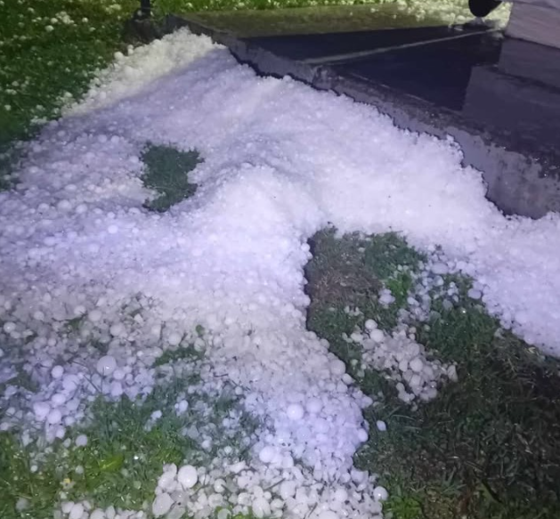
On this cold front, still severe storms were occurring from 5. to 6. May 2025, mainly in Italy, Slovenia, Croatia, Bosnia and Herzegovina, Serbia, Romania and Moldova. Hail up to 5 cm and regional floods have appeared.
Very impressive were minimum temperatures reached on 6. May 2025 in the British Islands and continental Europe: Altnaharra, the UK, -4,7°C, Bobruisk, Belarus, -4,5°C, Klicev, Belarus, -3,9°C, Minsk, Belarus, -3,8°C, Alytus, Lithuania, -3,2°C, Suwalki, Poland, -3,2°C, Torun, Poland, -3,2°C, Vilnius, Lithuania, -3,2°C, Bialystok, Poland, -2,9°C, Daugavpils, Latvia, -2,5°C, Cottbus, Germany, -1,2°C, Palacios de La Sierra, Spain (1050 MASL), -0,9°C, Poznan, Poland, -0,9°C, Liberec, Czechia, -0,7°C, Dublin, Ireland, -0,6°C, Mullingar, Ireland, -0,2°C, León, Spain (916 MASL), 0,0°C.
Colder was only in Scandinavia, Kilpisjarvi Saana, Finland, reported -9,4°C, and Katterjakk, Sweden, -8,9°C.
Even more interesting should be maximum temperatures on 6. May 2025, with only +5/+10°C temperatures including lowlands: Mende, France (932 MASL), +7,9°C, Le Puy, France (832 MASL), +8,3°C, Hohenpeissenberg, Germany (977 MASL), +5,1°C, Oberstdorf, Germany (804 MASL), +6,4°C, Achenkirch, Austria (931 MASL), +5,6°C, Salzburg, Austria (419 MASL), +8,9°C, Cervena, Czechia (748 MASL), +7,7°C, Zakopane, Poland (855 MASL), +6,8°C, Krosno, Poland (329 MASL), +9,3°C, Liesek, Slovakia (692 MASL), +8,0°C, Poprad, Slovakia (703 MASL), +8,9°C, Pakri, Estonia (23 MASL), +6,6°C, Tallin, Estonia (33 MASL), +8,6°C, Ventspils, Latvia (2 MASL), +7,8°C, Palanga, Lithuania (10 MASL), +8,8°C, Lviv, Ukraine (323 MASL), +9,2°C, Lisca, Slovenia (947 MASL), +6,0°C, Puntijarka, Croatia (991 MASL), +6,7°C, Nestares, Spain (870 MASL), +7,9°C.
As we mentioned in the last articles (links above), heatwaves are forecast to return above the continent after 20. May, maybe until 10.-15. June 2025, shifting from the West to the East. Summer 2025 forecast you can find here: https://mkweather.com/summer-2025-forecast-for-europe/.
FROSTS IN EUROPE
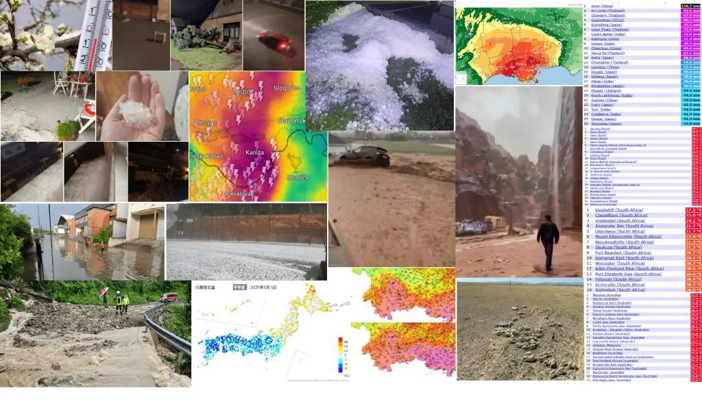
SEVERE STORMS WITH GUSTS, HEAVY RAINFALL AND HAIL IN CROATIA, BOSNIA AND HERZEGOVINA, ROMANIA, SLOVENIA AND ITALY


Regions in Croatia, 5.5.2025 in the evening. Source: https://www.jutarnji.hr/vijesti/hrvatska/olujno-nevrijeme-poharalo-vinkovce-slavoniju-15580963

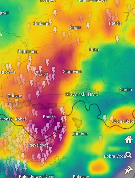
Storm in Šumece, Croatia on radar. Source: https://www.facebook.com/photo?fbid=1075564937953227&set=a.658645506311841


Hailstorm in Donji Smrtici, Bosnia and Herzegovina. Source: https://www.facebook.com/Prnjavor.i/posts/1130850025735134,https://www.facebook.com/watch/?v=680114048338407&t=4

Flood in Nazna, Romania. Source: https://www.facebook.com/watch/?v=1017112130527195
HEAVY RAINS AND HAIL IN BARCELONA AND GIRONA, SPAIN


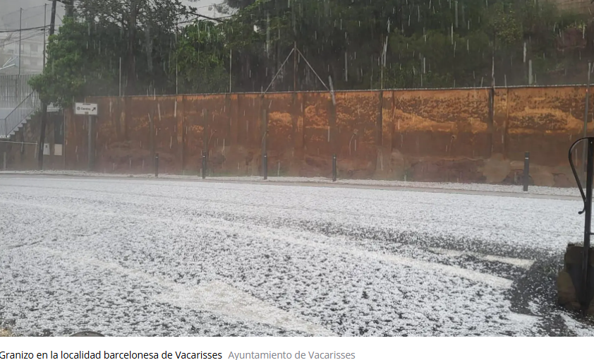
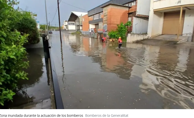
Hail and floods in Barcelona and Girona region, Spain. Source: https://cronicaglobal.elespanol.com/vida/20250505/la-lluvia-causa-inundaciones-metropolitana-barcelona-girona/1003742654948_0.html

Damaging lightening in Italy. Source: https://www.meteonetwork.it/tt/stormreport/asset/photo/28099_1746462456.9365.jpg


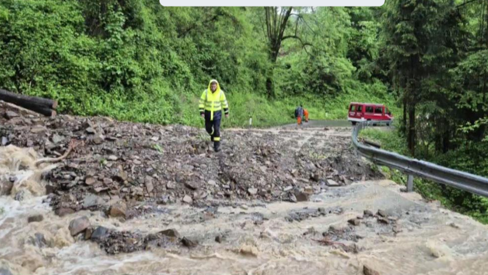
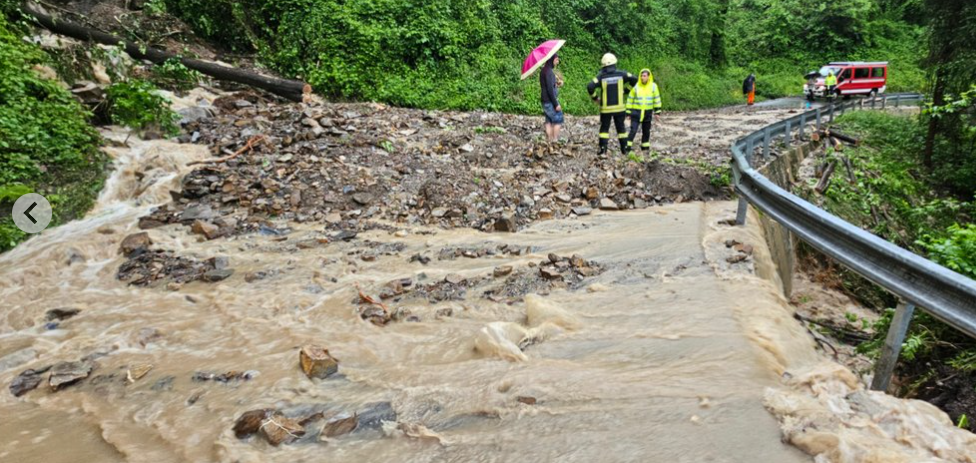
Cerkno, Slovenia. Source: https://www.rtvslo.si/okolje/vreme/v-cerknem-se-je-hudourniska-reka-ponoci-umirila/744767; https://www.24ur.com/novice/slovenija/sprozena-sirena-v-cerknem-na-severnem-primorskem-nevihte-in-plazovi.html
heavy rainto map | Zrenjanin Serbia (45.38 N, 20.38 E) < 10 km 06-05-2025 (Tuesday) 17:15 UTC (+/- 3 hrs.) | based on information from: an eye-witness report, a report on a website duration of precipitation: 2.5 hours Number of people injured: 0. Number of people dead: 0. My online friend texted me about the heavy rain. Decided to make this report because the storms will be lasting over another 2.5 hours while the rain will be heavy for the whole duration. https://www.accuweather.com/en/rs/zrenjanin/300671/minute-weather-forecast/300671 report status: as received (QC0)contact: Tomáš Hanáček |
severe windto map | Bokšić Region Vukovarsko-Srijemska Croatia (45.19 N, 19.10 E) < 10 km 05-05-2025 (Monday) 20:53 UTC (+/- 15 min.) | based on information from: a report on a website, a newspaper report Impacts: Power transmission damaged or destroyed several villages without power https://www.jutarnji.hr/vijesti/hrvatska/olujno-nevrijeme-poharalo-vinkovce-slavoniju-15580963 Reference: Jako olujno nevrijeme poharalo Slavoniju, ljudi u vodi do koljena, automobili idu kroz bujice, pogledajte dramatične snimke!, Jutarnji.hr, 6 May 2025. RAD. report status: plausibility check passed (QC0+)contact: Gabriel Strommer (ESWD management) |
heavy rainto map | Vukovar Region Vukovarsko-Srijemska Croatia (45.38 N, 18.96 E) < 10 km 05-05-2025 (Monday) 20:45 UTC (+/- 15 min.) | based on information from: a report on a website, a newspaper report Impacts: Basement(s) flooded, Flooding of ground floor fire department came into action many times https://www.jutarnji.hr/vijesti/hrvatska/olujno-nevrijeme-poharalo-vinkovce-slavoniju-15580963 Reference: Jako olujno nevrijeme poharalo Slavoniju, ljudi u vodi do koljena, automobili idu kroz bujice, pogledajte dramatične snimke!, Jutarnji.hr, 6 May 2025. RAD. report status: report confirmed by reliable source (QC1)contact: Gabriel Strommer (ESWD management) |
severe windto map | Vukovar Region Vukovarsko-Srijemska Croatia (45.38 N, 18.96 E) < 10 km 05-05-2025 (Monday) 20:35 UTC (+/- 30 min.) | based on information from: a report on a website, a newspaper report intensity and other characteristics: IF0.5 , Damage Indicator: TRW, Degree of Damage: 3 Impacts: Road(s) impassable or closed, Tree(s) uprooted or snapped fire department came into action because of multiple uprooted trees https://www.jutarnji.hr/vijesti/hrvatska/olujno-nevrijeme-poharalo-vinkovce-slavoniju-15580963 Reference: Jako olujno nevrijeme poharalo Slavoniju, ljudi u vodi do koljena, automobili idu kroz bujice, pogledajte dramatične snimke!, Jutarnji.hr, 6 May 2025. RAD. report status: report confirmed by reliable source (QC1)contact: Gabriel Strommer (ESWD management) |
heavy rainto map | Vinkovci Vukovarsko-Srijemska Croatia (45.29 N, 18.80 E) < 5 km 05-05-2025 (Monday) 20:20 UTC (+/- 30 min.) | based on information from: a report on a website, photograph(s) and/or video footage of the inflicted damage, a newspaper report, photo or video of the event Impacts: Road(s) impassable or closed, Basement(s) flooded basements flooded, roads flooded several dm deep https://www.jutarnji.hr/vijesti/hrvatska/olujno-nevrijeme-poharalo-vinkovce-slavoniju-15580963 Reference: Jako olujno nevrijeme poharalo Slavoniju, ljudi u vodi do koljena, automobili idu kroz bujice, pogledajte dramatične snimke!, Jutarnji.hr, 6 May 2025. RAD. report status: report confirmed by reliable source (QC1)contact: Gabriel Strommer (ESWD management) |
severe windto map | Vinkovci Vukovarsko-Srijemska Croatia (45.29 N, 18.80 E) < 5 km 05-05-2025 (Monday) 20:10 UTC (+/- 30 min.) | based on information from: a report on a website, photograph(s) and/or video footage of the inflicted damage, a newspaper report intensity and other characteristics: IF0.5 , Damage Indicator: TRW, Degree of Damage: 3 the intensity rating was based on a written account of the damage (e.g. in a newspaper). Impacts: Road(s) impassable or closed, Power transmission damaged or destroyed, Tree(s) uprooted or snapped multiple trees were uprooted https://www.jutarnji.hr/vijesti/hrvatska/olujno-nevrijeme-poharalo-vinkovce-slavoniju-15580963 Reference: Jako olujno nevrijeme poharalo Slavoniju, ljudi u vodi do koljena, automobili idu kroz bujice, pogledajte dramatične snimke!, Jutarnji.hr, 6 May 2025. RAD. report status: report confirmed by reliable source (QC1)contact: Gabriel Strommer (ESWD management) |
severe windto map | Vinkovci- Ciglarskoj ulici Vukovarsko-Srijemska Croatia (45.29 N, 18.78 E) < 1 km 05-05-2025 (Monday) 20:10 UTC (+/- 30 min.) | based on information from: a report on a website, a newspaper report Impacts: Rail-/tram-/subway(s) unusable or closed, Tree(s) uprooted or snapped tree fell onto railway https://www.jutarnji.hr/vijesti/hrvatska/olujno-nevrijeme-poharalo-vinkovce-slavoniju-15580963 Reference: Jako olujno nevrijeme poharalo Slavoniju, ljudi u vodi do koljena, automobili idu kroz bujice, pogledajte dramatične snimke!, Jutarnji.hr, 6 May 2025. RAD. report status: report confirmed by reliable source (QC1)contact: Gabriel Strommer (ESWD management) |
heavy rainto map | Slavonski Brod Region Brodsko-Posavska Croatia (45.17 N, 18.22 E) < 20 km 05-05-2025 (Monday) 19:15 UTC (+/- 1 hrs.) | based on information from: a report on a website, a newspaper report Impacts: Basement(s) flooded several/many basements flooded https://www.jutarnji.hr/vijesti/hrvatska/olujno-nevrijeme-poharalo-vinkovce-slavoniju-15580963 Reference: Jako olujno nevrijeme poharalo Slavoniju, ljudi u vodi do koljena, automobili idu kroz bujice, pogledajte dramatične snimke!, Jutarnji.hr, 6 May 2025. RAD. report status: report confirmed by reliable source (QC1)contact: Gabriel Strommer (ESWD management) |
severe windto map | Slavonski Brod Region Brodsko-Posavska Croatia (45.17 N, 18.24 E) < 20 km 05-05-2025 (Monday) 19:10 UTC (+/- 1 hrs.) | based on information from: a report on a website, a newspaper report intensity and other characteristics: IF0.5 , Damage Indicator: TRW, Degree of Damage: 3 the intensity rating was based on a written account of the damage (e.g. in a newspaper). Impacts: Tree(s) uprooted or snapped multiple trees fell on roads https://www.jutarnji.hr/vijesti/hrvatska/olujno-nevrijeme-poharalo-vinkovce-slavoniju-15580963 Reference: Jako olujno nevrijeme poharalo Slavoniju, ljudi u vodi do koljena, automobili idu kroz bujice, pogledajte dramatične snimke!, Jutarnji.hr, 6 May 2025. RAD. report status: report confirmed by reliable source (QC1)contact: Gabriel Strommer (ESWD management) |
large hailto map | Šumeće Brodsko-Posavska Croatia (45.08 N, 17.88 E) < 1 km 05-05-2025 (Monday) 18:20 UTC (+/- 5 min.) | based on information from: an eye-witness report, a report on a website, a newspaper report, photo or video of the event maximum hail diameter: 3 cm hailstorm; large hail, hail-size 2-3 cm id; video in the comments of the Facebook post; time estimated by radar data; https://www.facebook.com/photo?fbid=1075564937953227&set=a.658645506311841 https://www.jutarnji.hr/vijesti/hrvatska/nezapamceno-nevrijeme-kod-slavonskog-broda-mjestani-ovo-ne-pamte-da-nije-bilo-raketa-iz-bih-steta-bi-bila-i-veca-15580880 Reference: an eye-witness report via Facebook, 5 MAY 2025; “Nezapamćeno nevrijeme kod Slavonskog Broda, mještani ovo ne pamte: ‘Da nije bilo raketa iz BiH, šteta bi bila i veća‘”, JUTARNJI, 05 MAY 2025 report status: report confirmed by reliable source (QC1)contact: Mario Sekulic (Voluntary Observer Person) / Thilo Kühne (ESSL) |
large hailto map | Donji Smrtići Republika Srpska Bosnia and Herzegovina (44.97 N, 17.76 E) < 3 km 05-05-2025 (Monday) 18:00 UTC (+/- 5 min.) | based on information from: an eye-witness report, a report on a website, photo or video of the event maximum hail diameter: 4 cm hailstorm; large hail up to 3 – 4 cm id; https://www.facebook.com/Prnjavor.i/posts/1130850025735134 Reference: Prnjavorinfo.com via Facebook, 5 MAY 2025; report status: report confirmed by reliable source (QC1)contact: Mario Sekulic (Voluntary Observer Person) |
large hailto map | Ilova Republika Srpska Bosnia and Herzegovina (44.93 N, 17.68 E) < 3 km 05-05-2025 (Monday) 17:50 UTC (+/- 5 min.) | based on information from: an eye-witness report, a report on a website, photo or video of the event maximum hail diameter: 3 cm hailstorm; large hail; https://www.facebook.com/watch/?v=680114048338407&t=4 Reference: Prnjavorinfo.com via Facebook, 5 MAY 2025; report status: report confirmed by reliable source (QC1)contact: Mario Sekulic (Voluntary Observer Person) |
heavy rainto map | Barcelona Catalunya Spain (41.39 N, 2.16 E) < 5 km 05-05-2025 (Monday) 17:05 UTC (+/- 15 min.) | based on information from: a newspaper report Impacts: Road(s) impassable or closed https://cronicaglobal.elespanol.com/vida/20250505/la-lluvia-causa-inundaciones-metropolitana-barcelona-girona/1003742654948_0.html Reference: “La lluvia causa inundaciones en el área metropolitana de Barcelona y Girona “, CRONICA GLOBAL, 05 MAY 2025 report status: report confirmed by reliable source (QC1)contact: Thilo Kühne (ESWD management/ESSL Team) |
heavy rainto map | Girona Catalunya Spain (41.98 N, 2.83 E) < 5 km 05-05-2025 (Monday) 15:30 UTC (+/- 30 min.) | based on information from: a newspaper report Impacts: Road(s) impassable or closed https://cronicaglobal.elespanol.com/vida/20250505/la-lluvia-causa-inundaciones-metropolitana-barcelona-girona/1003742654948_0.html Reference: “La lluvia causa inundaciones en el área metropolitana de Barcelona y Girona “, CRONICA GLOBAL, 05 MAY 2025 report status: report confirmed by reliable source (QC1)contact: Thilo Kühne (ESWD management/ESSL Team) |
heavy rainto map | Nazna Transilvania – Mureș Romania (46.53 N, 24.48 E) < 3 km 05-05-2025 (Monday) 15:15 UTC (+/- 30 min.) | based on information from: a report on a website, photograph(s) and/or video footage of the inflicted damage, photo or video of the event Impacts: Road(s) impassable or closed, Car(s) damaged (unspecified) https://www.facebook.com/prognozemeteopersonale/videos/1017112130527195 Reference: Severe Weather Alert – România (Facebook), 05 MAY 2025 report status: report confirmed by reliable source (QC1)contact: Thilo Kühne (ESWD management/ESSL Team) |
heavy rainto map | Fedoreuca Raionul Orhei Moldova (47.49 N, 28.64 E) < 3 km 05-05-2025 (Monday) 14:30 UTC (+/- 1 hrs.) | based on information from: an eyewitness report of the damage, a report on a website, photograph(s) and/or video footage of the inflicted damage, a newspaper report Impacts: Farmland flooded Flooded farmland was reported. The time was estimated via radar. https://t.me/gazetasp/29914 Reference: СП: esp.md | Новости – Бельцы и Молдова (on Telegram), 05 MAY 2025. report status: report confirmed by reliable source (QC1)contact: Alexandr Dașevschii (Voluntary Observer Person) |
large hailto map | Vacarisses Catalunya Spain (41.60 N, 1.92 E) < 3 km 05-05-2025 (Monday) 14:25 UTC (+/- 15 min.) | based on information from: an eye-witness report, a report on a website, photo or video of the event maximum hail diameter: 2 cm https://x.com/ajvacarisses/status/1919427159535317206 Reference: Ajuntament de Vacarisses (X), 05 MAY 2025 report status: report confirmed by reliable source (QC1)contact: Thilo Kühne (ESWD management/ESSL Team) |
damaging lightningto map | Viola (Saint Gree) Piemonte Italy (44.28 N, 7.96 E) < 1 km 05-05-2025 (Monday) 14:12 UTC (+/- 1 min.) | based on information from: an eye-witness report, an eyewitness report of the damage, photograph(s) and/or video footage of the inflicted damage Impacts: Building(s) damaged, Tree(s) damaged Albero colpito, i detriti hanno danneggiato un edificio // Tree struck, the debris damaged a building https://www.facebook.com/groups/stgreeviola/permalink/4057599304558878/ Reference: Daniele Dallorto (on Facebook), 05 May 2025 report status: report confirmed by reliable source (QC1)contact: PRETEMP – Previsione temporali |
damaging lightningto map | Pisogne Lombardia Italy (45.80 N, 10.12 E) < 3 km 05-05-2025 (Monday) 13:45 UTC (+/- 15 min.) | based on information from: an eye-witness report, an eyewitness report of the damage, photograph(s) and/or video footage of the inflicted damage Impacts: Tree(s) damaged, Fire as a consequence of the event https://www.meteonetwork.it/tt/stormreport/asset/photo/28099_1746462456.9365.jpg Reference: Orgoglio Bresciano (on Instagram), 05 May 2025 report status: report confirmed by reliable source (QC1)contact: PRETEMP – Previsione temporali |
large hailto map | Vigodarzere (Saletto) Veneto Italy (45.48 N, 11.86 E) < 3 km 05-05-2025 (Monday) 13:20 UTC (+/- 5 min.) | based on information from: a trained storm spotter, an eye-witness report, an eyewitness report of the damage, a report on a website, photo or video of the event maximum hail diameter: 3 cm http://stormreport.meteonetwork.it/asset/photo/28064_1746455240.6334.jpg https://www.facebook.com/groups/376173012408717/permalink/30405503172382305/ report status: report confirmed by reliable source (QC1)contact: MeteoNetwork Pretemp |
large hailto map | Işıklı Osmaniye Province Turkey (37.50 N, 35.99 E) < 3 km 05-05-2025 (Monday) 13:20 UTC (+/- 15 min.) | based on information from: a newspaper report maximum hail diameter: 3 cm Impacts: Crops/farmland damaged Walnut-sized hail https://www.sondakika.com/3-sayfa/haber-osmaniye-de-ceviz-buyuklugunde-dolu-yagisi-18592661/ Reference: “Osmaniye’de Ceviz Büyüklüğünde Dolu Yağışı”, SON DAKIKA, 05 MAY 2025 report status: report confirmed by reliable source (QC1)contact: Thilo Kühne (ESWD management/ESSL Team) |
large hailto map | Akdam Osmaniye Province Turkey (37.48 N, 35.98 E) < 3 km 05-05-2025 (Monday) 13:15 UTC (+/- 15 min.) | based on information from: a newspaper report maximum hail diameter: 3 cm Impacts: Crops/farmland damaged Walnut-sized hail https://www.sondakika.com/3-sayfa/haber-osmaniye-de-ceviz-buyuklugunde-dolu-yagisi-18592661/ Reference: “Osmaniye’de Ceviz Büyüklüğünde Dolu Yağışı”, SON DAKIKA, 05 MAY 2025 report status: report confirmed by reliable source (QC1)contact: Thilo Kühne (ESWD management/ESSL Team) |
heavy rainto map | Cerkno Slovenia (46.13 N, 13.98 E) < 10 km 05-05-2025 (Monday) 13:00 UTC (+/- 30 min.) | based on information from: a report on a website precipitation: 85 mm duration of precipitation: 3 hours Impacts: Road(s) impassable or closed, Road(s) damaged or destroyed, Inhabited place(s) cut off from transport infrastructure, Basement(s) flooded, Flooding of ground floor, Land- or mudslide(s) Number of people injured: 0. Number of people dead: 0. Stationary convection over NN-W Slovenia. https://www.rtvslo.si/okolje/vreme/v-cerknem-se-je-hudourniska-reka-ponoci-umirila/744767 https://www.24ur.com/novice/slovenija/sprozena-sirena-v-cerknem-na-severnem-primorskem-nevihte-in-plazovi.html report status: as received (QC0)contact: Blaž Šter |
large hailto map | Vicoforte Piemonte Italy (44.37 N, 7.86 E) < 3 km 05-05-2025 (Monday) 12:50 UTC (+/- 15 min.) | based on information from: a trained storm spotter, an eye-witness report, an eyewitness report of the damage, a report on a website, photo or video of the event maximum hail diameter: 2 cm http://stormreport.meteonetwork.it/asset/photo/28074_1746459170.4884.jpg https://www.facebook.com/photo/?fbid=692130526664149&set=a.200568545820352 https://www.facebook.com/watch/?ref=saved&v=1185260082926868 https://unionemonregalese.it/2025/05/05/forte-grandinata-sul-monregalese-fotogallery/?fbclid=IwY2xjawKFvGZleHRuA2FlbQIxMABicmlkETBoYnJoUUdvaDJxNHdJcXppAR474N_rX5FbF2mKUX5pgpFFadWYlHPsSzWSgLVrZS1DRtJu7TWrjjMzxyNHPQ_aem_9TQ0zCDJN6DGq54js1ioIg report status: report confirmed by reliable source (QC1)contact: MeteoNetwork Pretemp |
large hailto map | Noventa Vicentina Veneto Italy (45.30 N, 11.55 E) < 3 km 05-05-2025 (Monday) 12:50 UTC (+/- 5 min.) | based on information from: a trained storm spotter, an eye-witness report, an eyewitness report of the damage, a report on a website, photo or video of the event maximum hail diameter: 2 cm Impacts: Car(s) dented http://stormreport.meteonetwork.it/asset/photo/28103_1746470146.2331.jpg report status: report confirmed by reliable source (QC1)contact: MeteoNetwork Pretemp |
Source: https://eswd.eu/cgi-bin/eswd.cgi
North America / The USA
From temperature records in the USA in the last 48 hours we have noticed mainly record warm nights in New York or Washington state, extremely hot days in Wyoming and Montana, such as cold records and weather in California, Arizona and New Mexico.
Islip, NY, reported on Sunday, 4.5.2025 Tmin +59°F.
Quilayute in Washington state reported on Monday, 5.5.2025 Tmin +33°F and Walla Walla in Washington state +34°F.
Greybull in Wyoming reported on Monday, 5.5.2025 Tmax +85°F.
Baker in Montana finished day on 5.5.2025 with Tmax +84°F.
5 stations in California reported the coldest 4. May in history, with Tmins +62/+72°F.
Monsoon rains with hail hit parts of Arizona and New Mexico, Phoenix reported Tmax only +74°F, which is the 7th coldest 5th May in history.
Severe storms are bothering the eastern half of the USA, such as Texas and Florida regions (some Tweets below). From current news we are choosing: Strong Storms, Flooding Possible In The South /https://weather.com/storms/severe/video/severe-weather-tornadoes-flood-storms-south-texas/, South, Northeast Stuck In A Stormy Pattern With Possible Severe Weather, Flooding This Week /https://weather.com/storms/severe/news/2025-05-04-plains-south-northeast-storms-rain-flooding-severe-forecast/, Severe storms to rattle areas in south-central, northeast and southeast US /https://www.accuweather.com/en/severe-weather/severe-storms-to-rattle-areas-in-south-central-northeast-and-southeast-us/1771822/, Northeast: Days of showers and thunderstorms for some, heavy rain for others /https://www.accuweather.com/en/weather-forecasts/northeast-days-of-showers-and-thunderstorms-for-some-heavy-rain-for-others/1771663/, Search underway for missing 10-year-old swept away by floodwaters in Texas /https://www.accuweather.com/en/weather-news/10-year-old-missing-after-texas-floodwaters-sweep-her-away/1772077/, and Soggy South Central states: Intense downpours to renew flooding risk /https://www.accuweather.com/en/weather-forecasts/soggy-south-central-states-intense-downpours-to-renew-flooding-risk/1771462/.
Warming and drying pattern for many parts of the continent is in the next weeks predicted, as we mentioned in the last daily Weather reports.
Summer 2025 forecast for North America and the USA you will find here: https://mkweather.com/summer-2025-forecast-for-north-america-and-the-usa-at-the-first-half-more-floods-at-the-second-half-peak-of-the-summer-strong-wildfire-season-on-the-west-deadly-tornado-and-hurricane-season-on-the-eas/.
NEW YORK AND SEATTLE REGIONS WITH A RECORD WARM NIGHTS
EXTREMELY HOT DAY IN WYOMING AND MONTANA
COLD WEATHER IN CALIFORNIA, ARIZONA AND NEW MEXICO
STORMS IN EASTERN HALF OF THE USA
Asia
After severe floods in Dimona, Israel, dramatic floods have shifted eastward and in the last hours hit Jordan, including Petra, where tourists were evacuated and a few died.
Meanwhile, heatwaves in the Middle East and Central Asia are regenerating, with historic Tmins in UAE and Oman: +39,1°C in Khassab, +38,2°C in Fujirah Port and +38,1°C in Fakkan Port, which is the highest minimum temperatures worldwide measured for 1. January to 15. May period. Sohar, Oman +45,7°C reported on 6. May 2025.
+40,3°C in Turkmenistan, +38°C in Kazakhstan where Bayyrkum set a new May record with +36,5°C were measured. The heat however will get much worse next days and will continue for any foreseeable future.
A result of Asian megaheatwaves we can see in wildfires in Siberia – Zabaikalsky region in Russia is currently 87% engulfed by smoke from wildfires.
Only before a few days, on 1. May 2025, however, was measured very cold -27,0°C in Tiksi, Russia, -27,0°C.
From other spring frost, Tulihe, China, reported -7,3°C on 5. May 2025, Mohe, China, -5,6°C on 6. May 2025 or Taegwallyong, South Korea, 842 MASL, -1,2°C on 5. May 2025.
Yoneyama in Japan recorded its lowest temperature in May in history, +1,1°C.
From other weather events we should mention heatwaves and severe storms in China ( in Yuanyang, Yunan, +43,3°C was measured, severe floods occured in Qianxi and Yanling).
Severe heatwaves +45/+50°C are forecast for parts of India and Pakistan in the next weeks. Afghanistan hit regional floods.
SE Asia is stormy and hot, with heat index above +50°C regionally.
Basco, Philippines, recorded Tmin +27,1°C – the highest minimum temperature in May in history.

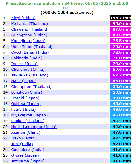
The highest rainfall in Asia on 6. May 2025. Source: https://ogimet.com/cgi-bin/gsynext?state=Asi&rank=500&ano=2025&mes=05&day=06&hora=20&Enviar=Ver
DRAMATIC FLOODS IN PETRA, JORDAN
+1,1°C IN YONEYAMA, JAPAN – A NEW ABSOLUTE TEMPERATURE MAY MINIMUM
+43,3°C IN CHINA
TURKMENISTAN AGAIN ABOVE +40°C (+40,3°C), KAZAKHSTAN +38°C
HEATWAVES IN THE MIDDLE EAST
FLOODS IN SOUTHERN ISRAEL
QIANXI AND YANLING, CHINA, WITH FLOODS
The boats reportedly turned over while on a river in the city of Qianxi, which caused 84 people to fall into the water. /https://www.accuweather.com/en/weather-news/10-dead-dozens-hospitalized-as-chinese-tourist-boats-capsize/1771798/-
HEATEAVES IN INDIA AND PAKISTAN
SEVERE STORMS WITH HEATWAVES IN SE ASIA – ABOVE +50°C REAL FEEL TEMPERATURES
FLOODS IN AFGHANISTAN
South America
The hottest in comparison with a long-term seasonal average is in Bolivia region these day. Is late Autumn, but in Puerto Suarez, Bolivia, maximum temperature on 6. May 2025 reached a supertropical +36,2°C.
Severe floods are reported from Itagui, Colombia and Santo Amaro, Brazil (Bahia).
From cloder regions, Bariloche, Argentina, 7/9 of last days reported frosts 0/-3°C. Balmaceda, Chile, reported -3,7°C on 4. May 2025.
Outlook is warm or hot for the South and Stormy for the North of the continent, as we mentioned in previous daily Weather reports.

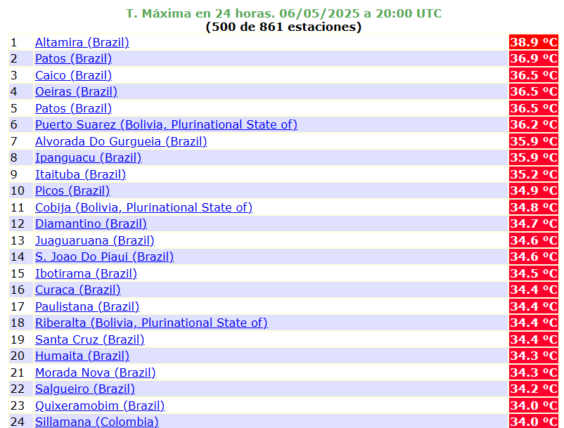
Maximum temperatures on 6. May 2025 in South America. Source: https://ogimet.com/cgi-bin/gsynext?state=Ames&rank=500&ano=2025&mes=05&day=06&hora=20&Enviar=Ver
FLOODS AND MUDSLIDE IN ITAGUI, COLOMBIA
FLOODS IN SANTO AMARO, BAHIA, BRAZIL
Africa
Heatwaves in South Africa is surprisingly powerful in late Autumn 2025, with anomalous temperature of +37,2°C in Vioolsdrif, South Africa.
Meanwhile, in Sahara and Sahel, the hottest is in Matam, Senegal, +44,3°C, and Nara and Nioro du Sahel, Mali, +44,3°C.
Tropical forests and many savannas are reporting severe storms and floods, a list of countries with flood risk we mentioned in the previous daily Weather report from Mkweather: https://mkweather.com/daily-weather-report-for-5-may-2025-coldwave-in-europe-will-last-long-2-weeks-bringing-snow-and-frosts-sweden-105c-finland-104c-the-uk-29c-poland-17c-the-netherlands-14c-denmark-13c-baltic-countries-1/.
HEATWAVES IN SOUTH AFRICA

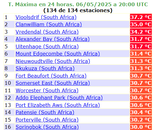
Maximum temperatures on 6. May 2025 in South Africa. Source: https://ogimet.com/cgi-bin/gsynext?state=South+A&rank=500&ano=2025&mes=05&day=06&hora=20&Enviar=Ver
FLOODS IN UGANDA
Australia
Australia reports a late-Autumn heatwaves, too, with Tmaxes up to +37,5°C in Mandora on 6. May 2025.
However, Tasmania is the warmest in comparison with weather averages, with the hottest May nights in history. In Flinders Island, Tmin +18,7°C was on 6. May 2025 measured.
Meanwhile, Mt. Hutt in New Zealand reports a record late-Autumn snowfall.
Dunedin, New Zealand, reported on 6. May 2025 only -1,0°C,
TASMANIA ALMOST WITH TROPICAL NIGHTS – THE HIGHEST MAY TEMPERATURE MINIMUM EVER!

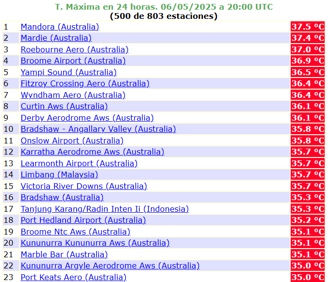
Maximum temperatures in Australia on 6. May 2025. Source: https://ogimet.com/cgi-bin/gsynext?state=Pacs&rank=500&ano=2025&mes=05&day=06&hora=20&Enviar=Ver
The Arctic and Antarctica
From the Arctic and Antarctica, we are today choosing a GW hole cooling trend in the North Atlantic, such a result of melting freshwater in the Arctic and measured temperatures in Vostok station, Antarctica, in the last 30 days.

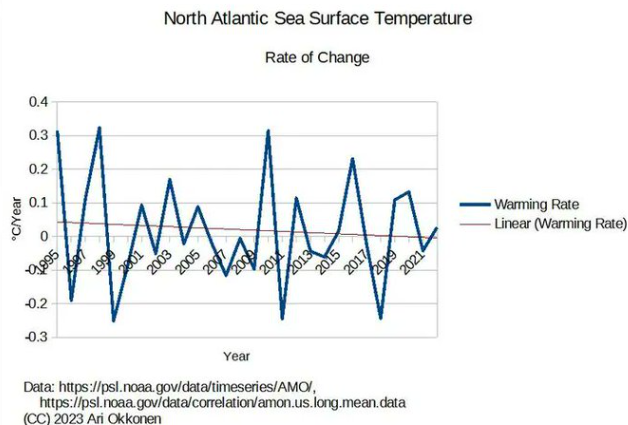
Source. https://twitter.com/AriOkkonen/status/1919370066346307656/photo/1

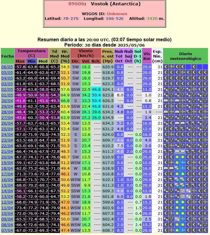
The last month in Vostok, Antarctica. Source: https://ogimet.com/cgi-bin/gsynres?ind=89606&ano=2025&mes=5&day=6&hora=20&min=0&ndays=30