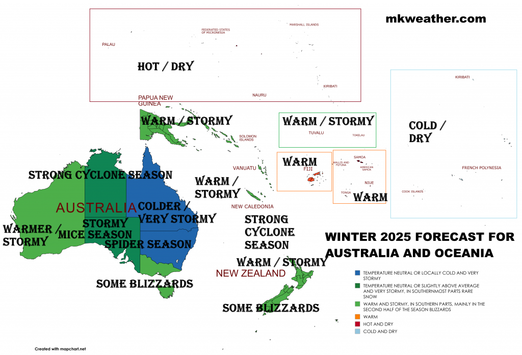
WINTER 2025 FORECAST FOR AUSTRALIA AND OCEANIA: STORMY / SNOWY SEASON – STRONG CYCLONE, SPIDER, AND MICE LA NINA SEASON AHEAD
Summer 2025 is almost here, and Mkweather (mkweather.com) is bringing the first continental updates of seasonal forecasts for Europe /https://mkweather.com/summer-2025-forecast-for-europe//, North America /https://mkweather.com/summer-2025-forecast-for-north-america-and-the-usa-at-the-first-half-more-floods-at-the-second-half-peak-of-the-summer-strong-wildfire-season-on-the-west-deadly-tornado-and-hurricane-season-on-the-eas//, and Asia for Summer 2025, Africa for Winter and Summer 2025, Australia, South America /https://mkweather.com/winter-2025-forecast-for-south-america-la-nina-aao-pdo-psa-dakar-nina-ao-nao-iod-amo-qbo-to-hot-and-dry-southern-brazil-bolivia-paraguay-stormy-rainforest-colombia-venezuela-gu//, and Antarctica for Winter 2025.
This article will look at the forecast Winter 2025 conditions in Australia.
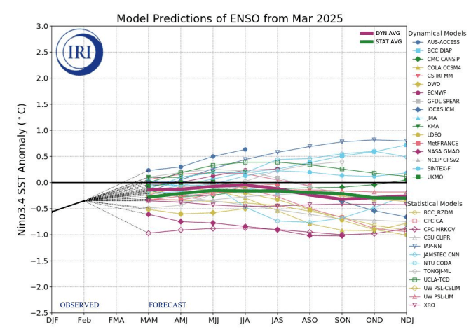
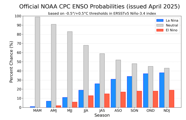
The La Nina pattern is predicted to strengthen in Winter (JJA) 2025, with a significant impact on Australian winter. La Nina will be supported with PDO- phase and in Indian Ocean region with IOD-, too.
La Nina is bringing typical stormy patterns to Australia, New Zealand, Papua New Guinea, and the Fiji region. The strongest manifestations of La Nina, together with PDO-, IOD- or PSA- will be visible in the eastern half of the continent, especially in continental parts, where local cold anomalies should appear in average.
Mainly in Western Australia, therefore, some winter heatwaves are expected.
A stormy, on the South snowy winter is predicted, in silvicultural regions with a very good fertile season, however with a lot of spiders and mice in wetter environment.
Cooling Antarctica, such a component of climate change, should affect mainly southernmost Australia, Tasmania and Southern Island of New Zealand, with a relatively higher intensity of blizzards, especially in the second half of the season, in case of neutral or AAO- phase during the upcoming winter. AAO trends from 1979 to 2025 or from 2000 to 2025 showed that in summer months (DJF), AAO+ phase is more frequent, but in winter months (JJA), a clearly neutral trend was found, which means chances for winter blizzards in the southernmost parts of continents in the Southern Hemisphere.
South Pacific tropical cyclone season and Australian cyclone season in northern seas and ocean waters regions therefore will be above-average, with powerful cyclones bringing heavy rainfall, severe winds, hail, damaging lightening, floods or landslides.
While above E-SE Australia, lower geopotential as average is expected, a Perth region should be affected by a strong blocking high about S-SE Indian Ocean in Winter 2025.
40-day MJO forecast promises a wet phase for the start of Winter 2025, with some surprises in the form of low pressure events, or even tropical activity in northern regions.
ITCZ should be shifted relatively northward, mainly above Indonesia and Papua, where extremely stormy season is predicted.
QBO slow shift from Westerlies to Easterlies should weaken westerlies and strengthen easterlies in the tropical stratosphere.
PSA- (Pacific South-American Oscillation) should contribute to wet and stormy anomaly in Australia and the SW Pacific.
Hawaii is expected to be very hot and stormy in Summer 2025, with a frequent floods or landslides.
A few main factors will be affecting conditions during the upcoming Winter 2025:
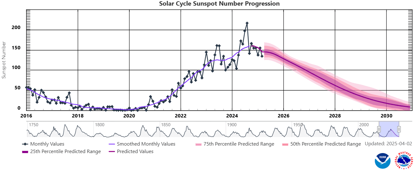
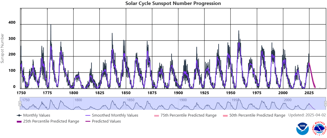
1. Sun cycle
Surprisingly strong solar activity during the peak of the current 25th solar cycle in the last years was associated with a strong phase of La Nina in its coming phase, it means from spring 2020 to spring 2023 (together 3 years of La-Nina driven climate anomalies around the Earth) and a short, but strong El-Nino in its peaking phase from Spring 2023 to Summer 2024. Now we are again in La Nina phase, but relatively weak La Nina, with a decrease of sunspots and geomagnetic storms, it means yearly lower chances for NAO+, mainly in the winter. In the Little Ice Age, a weak Sun activity produced Godzilla El-Ninos and strong AO- and NAO- patterns across the Northern Hemisphere with a result in hunger, bad harvests, diseases, fear, and finally, an inquisition. A peak of the strong solar activity was observed between 1950 – 2000, and from then, activity was decreasing, however, the last cycle was observed surprising increase of the Sun activity, with surprising events in the first half of 2024.
From 21. to 22. February 2024 there was a big chance, that the Sun produced the strognest Triple-eruption in 24-hours In the last 30 years, maybe since 1900, maybe since pre-Middle age times (Middle ages hadn´t strong Sun stroms). There have been 3 Triple-eruptions in the last 20 years:
2013: weaker intensity 5/13/2013 2:17 N11E89 X1.75/13/2013 16:01 N11E85 X2.85/14/2013 1:11 N08E77 X3.2.
2014: weaker intensity 6/10/2014 11:44 6/10/2014 11:42 S15E80 X2.26/10/2014 13:03 6/10/2014 12:52 S17E82 X1.56/11/2014 9:10 6/11/2014 9:06 S18E65 X1.0.
2017: main eruption stronger, but 24-hour criterion not met9/6/2017 9:17 9/6/2017 9:10 S08W32 X2.29/6/2017 12:10 9/6/2017 12:02 S09W34 X9.39/7/2017 14:55 9/7/2017 14:36 S11W49 X1.3.
Year 2003 brought 2 giant eruptions, but again only 2 in 24 hours and not 3, does not meet criteria (https://sos.noaa.gov/catalog/datasets/sun-historical-solar-flare-2003/).
Previously the solar cycle peaked between 1989-1992: “The next 14 days produced 11 “X class” flares” March 1989: The largest geomagnetic storm in the 20th century: (https://agupubs.onlinelibrary.wiley.com/…/2019SW002278).
But even the strongest storm in 100 years did not produce 3 X ray bursts in 24 hours: (https://agupubs.onlinelibrary.wiley.com/…/swe20919-fig).
Stronger solar cycles occurred 3 more times from the 1950s to the 1970s, but we don’t know if there was a triple burst. If not, it may be the strongest triple burst since before the Middle Ages, when solar activity was at a strong minimum. Database: https://xrt.cfa.harvard.edu/flare_catalog/all_full.html.
The strongest geomagnetic storm in 21. century? The strongest since 1960 and the second strongest in 100 years? According to estimates of the daily Ap index for 11.5.2024, Ap 274 was measured (note: current Spaceweather data contains a number 271), which should be the second strongest X-ray attack on our bodies in 24 hours in almost 100 years (since 1932) (in modern history)! Stronger was only 1960 with Ap 280. If we overcame single days in the years 1989 and 2003, it will be the strongest geomagnetic storm since 1960 (in 64 years), which is a once-in-a-lifetime event. Moreover, weakening of solar cycles in 21. century is mostly expected, which should mean that this should be the strongest geomagnetic storm in 21. century! https://www.spaceweatherlive.com/…/top-50-geomagnetic…https://www.spaceweather.gov/…/aurora-dashboard….
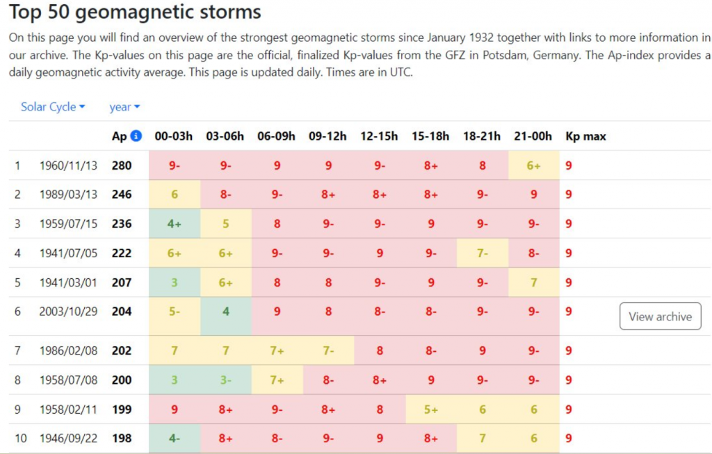
The strongest 24-hour geomagnetic storms until 11. May 2024 (placed in second place) /Source: spaceweather.com
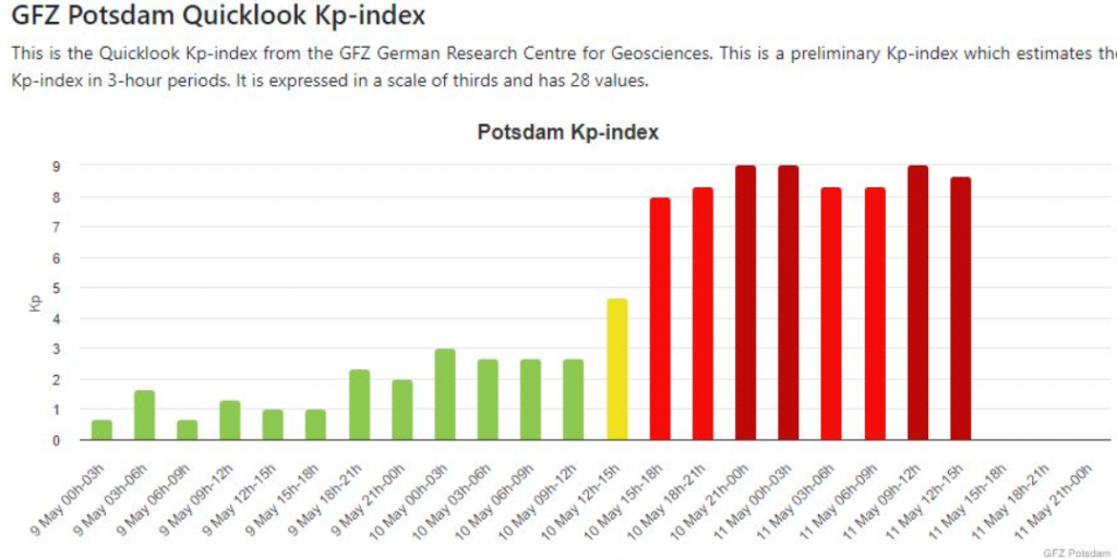
Source: https://kp.gfz.de/en/hp30-hp60
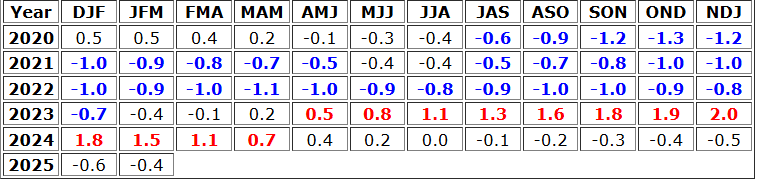
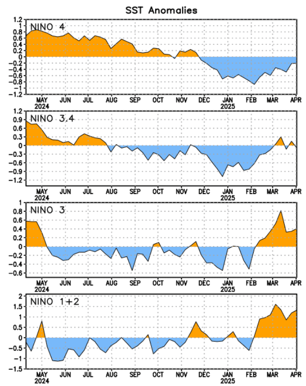
2. Probable strengthening La Nina
During Winter 2025 a shift from neutral phase to weaker La Nina pattern is predicted.
Upcoming La Nina should have an impact on the growing season – mainly stormier inhabited SE Australia, especially New South Wales and Victoria regions. The Perth region should be fertile, but with heatwaves from a blocking high above the S-SE Indian Ocean.
On the South, stronger pressure lows and frontal boundaries are possible, especially on the Southeast and in Queensland, while northernmost parts of the continent should be surprised by the activity of the tropical storms, or even cyclones.
During stormy pattern, a spider and a mice season are stronger.
Meanwhile, islands in northern Oceania, e.g. Kiribati, will be hot and dry thanks to La nina.
The region of French Polynesia should be cold and dry during La Ninas, due to a cold SST anomaly above all Eastern Pacific.
3. PDO-
La Nina in combination with IOD- and PDO- is bringing warm western Pacific, with above-average storm activity, and simultaneously, the cold eastern Pacific, with below-average storm activity.
Western shores of Australia therefore will be stormier, thanks to higher SSTs (Sea surface temperatures).
PDO is predicted to stay in its negative phase all year 2025. PDO- however, should be gradually weakening.
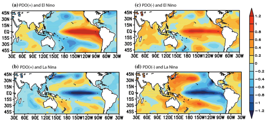
Warm SSTs during La Nina and PDO- above Asian seas. Source: https://www.researchgate.net/figure/Composites-of-SST-anomalies-during-a-the-warm-phase-of-the-PDO-and-El-Nino-years-b-the_fig3_283050507
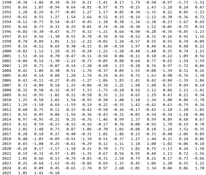
Evolution of PDO index. Source: https://www.cpc.ncep.noaa.gov/products/precip/CWlink/pna/norm.pna.monthly.b5001.current.ascii.table
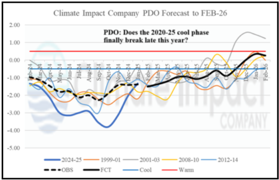
PDO forecast. Source: https://climateimpactcompany.com/february-2025-enso-pdo-amo-and-iod-outlook-2-2/
4. AAO and Antarctica
Cooling Antarctica, such a component of climate change, should affect mainly southernmost parts of Australia, Tasmania and New Zealand with a relatively higher intensity of blizzards, especially in the second half of the season, in case of neutral or AAO- phase during upcoming winter.
The cold Antarctic air should shift temporarily northward, to northern Australia or Fiji regions, with some cooling effects, of course, without snow.
AAO trends from 1979 to 2025 or from 2000 to 2025 showed, that in summer months (DJF), AAO+ phase is more frequent, but in winter months (JJA), clearly neutral trend was found, what mean chances for winter blizzards in southernmost parts of continents in Southern Hemisphere.
If we notice on the graph the year 2010 – with extreme negative AO and NAO phases in the Northern Hemisphere, we can read from the graph an anomalous AAO+ phase, in contrast.
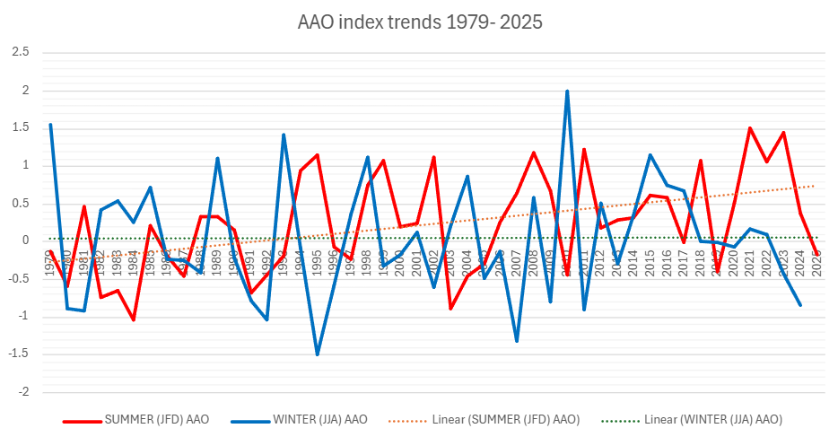
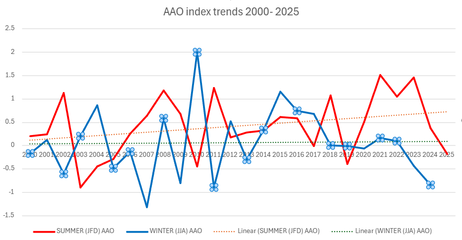
AAO index trends in summer and winter months. Source: https://www.cpc.ncep.noaa.gov/products/precip/CWlink/daily_ao_index/aao/monthly.aao.index.b79.current.ascii.table
5. A shift of Hadley Cell southward
Likewise in the Northern Hemisphere, in Southern Hemisphere is Hadley cell similarly shifted more soutward.
The shift is not so powerful, partly thanks to changes in Antarctica, and partly thanks to large area of cooling oceans in the Southern Hemisphere.
The shifted mid-latutidinal stormtrack should hit more southern regions in this changed climate. Rossby waves, however, should produce long pressure troughs with low-latitude situated lows and extreme high-latitude heatwaves on their front sides during a collapsing jet-stream.
However, in summers, AAO+ trend means more stabilizing shift of climate, against to expected shifts of Hadley cell in the moderate climate zone in the Southern Hemisphere. Australia belongs mainly to a subtropical, tropical, and subequatorial climate zone, therefore, the AAO+ effect for summers is minimal, still with deadly heatwaves and wildfires arriving from the continent. The most important effects are therefore attributed to La Nina.
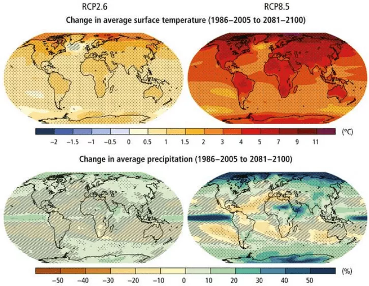
RCP8.5 (CMIP5) (IPCC, 2014). Note: precipitation changes in Europe are strongly linked with a shift of Hadley cell northward.
6. South Pacific tropical cyclone season
After one of the weakest South Pacific tropical cyclone season, due to ending El Nino in earlier 2024 and neutral ENSO phase from 2024 to 2025, stronger cyclone season in 2025-2026 is predicted.
In the ending season, only 2 Category 2 storms have appeared in February 2025 – Rae and Seru. The next 9 systems have been developed, together 11 in total.
La Nina and PDO-, such as IOD- and PSA- will be a good signal for more powerful season.
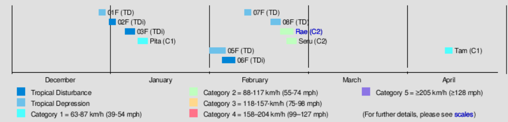
An ending very weak South Pacific tropical cyclone season. Source: https://en.wikipedia.org/wiki/2024%E2%80%9325_South_Pacific_cyclone_season
7. Australian cyclone season in Indian Ocean
In contrast, the 2024 – 2025 Australian region cyclone season was the most active season in the Australian region since 2005 – 2006.
La Nina, PDO-, and IOD- can preserve very strong trend in the activity during the upcoming season 2025-2025, starting from 1. July 2025 and ending on 30. June 2026.
From the strongest storms, Zella, Category 5, Courtney, Category 5, Sean, Category 4, Bianca, Category 4, Alfred, Category 4 or Errol, Category 4 bothered continents, seas and ocean waters in the continent during the ending season.
In Winter 2025, mainly northern parts of Australia should be hit by the next cyclones, as well as Indonesia and Papua.
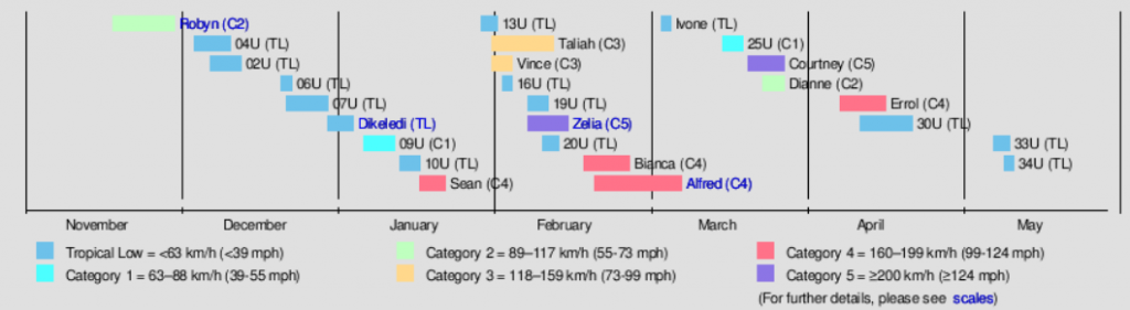
An ending Cyclone season summary. Source: https://en.wikipedia.org/wiki/2024%E2%80%9325_Australian_region_cyclone_season
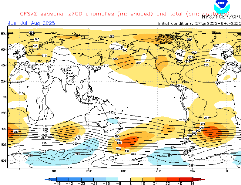
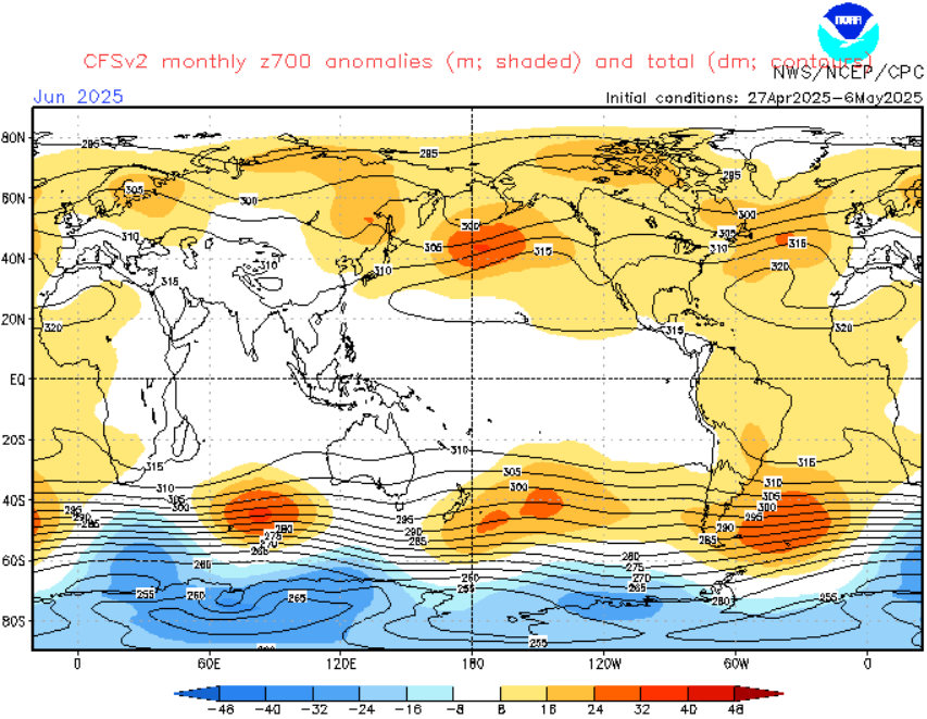
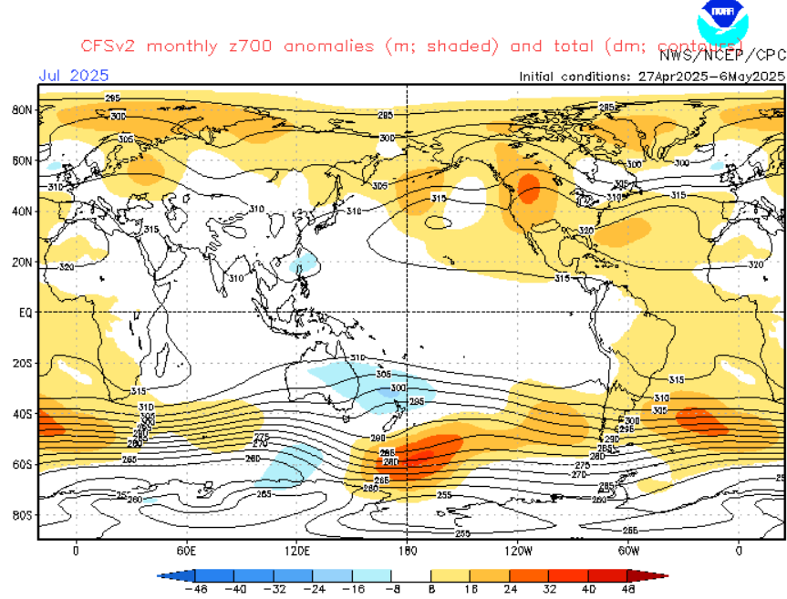
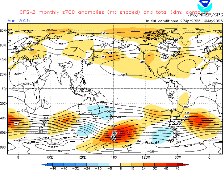
8. Blocking high above S-SE Indian Ocean and Pressure lows above eastern half of the continent
According to z700 geopotential level output for the region, a strong and persistent pressure high will be occurring above the S-SE Indian Ocean during the season.
The anomaly will be developing during the summer and peaking around August 2025, when will be the highest probability for some drought in Perth region, Western Australia.
Meanwhile, above eastern Australia and western New Zealand, a pressure low systems will be regenerating according to CFSv2, which means more storms or floods, and some snow in the South.
Both anomalies will be the strongest around August 2025.
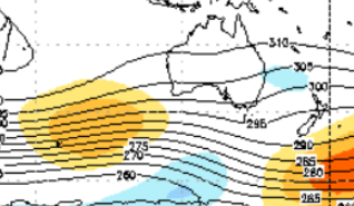
z700 output from cfsv2 or the region. Up all Winter 2025, down only August 2025. Source: Source: https://www.cpc.ncep.noaa.gov/products/CFSv2/CFSv2_body.html
9. Wildfire and drought season
Thanks to La Nina, PDO-, IOD-, PSA-,… a weak winter wildfire season is expected.
Wildfires should appear mainly in Western Australia, with some heatwaves and drought, and then in the desert, continental parts.
10. Shifts of the ITCZ and the monsoon season in the northern Amazon rainforest
ITCZ will be in Winter 2025 shifted more northward, to Indonesia, or Papua New Guinea. Conditions in Asia we have described in Summer 2025 forecast for Asia /https://mkweather.com/summer-2025-forecast-for-asia-a-strong-typhoon-and-cyclone-season-record-heatwaves-for-central-asia-hot-middle-east-stormy-in-the-south-hot-china-north-stormy-south-drier-dry-west-and-stormy//.
11. La Nina-driven SSTs
Cold waters of the eastern Pacific will result in cold and dry French Polynesia and some equatorial regions.
Warm SSTs in Western Pacific, especially near eastern Australia, New Zealand, Papua or Fiji should be linked with the stronger Cyclone season and more precipitation than average.
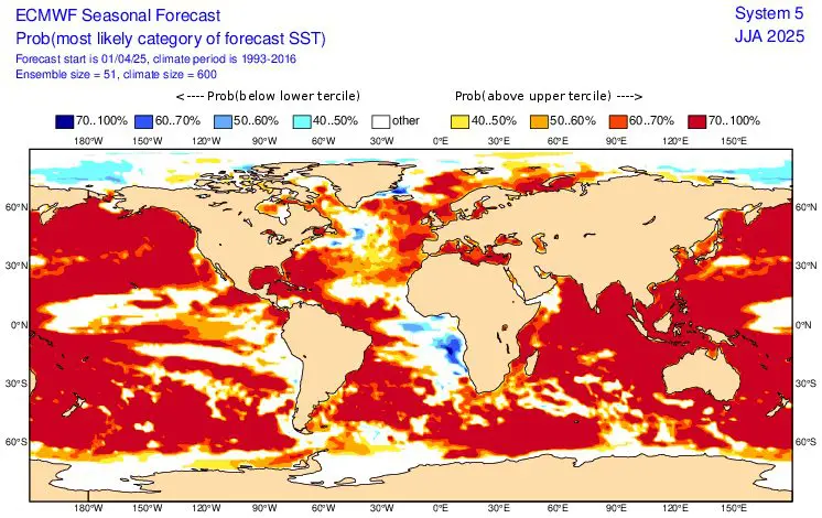
SSTs forecast for JJA 2025 (Summer 2025). Source: https://charts.ecmwf.int/products/seasonal_system5_standard_ssto?area=GLOB&base_time=202504010000&stats=tsum&valid_time=202506020000
12. MJO
40-day MJO forecast promises a wet phase for the start of Winter 2025, with some surprises in the form of low pressure events, or even tropical activity in northern regions.
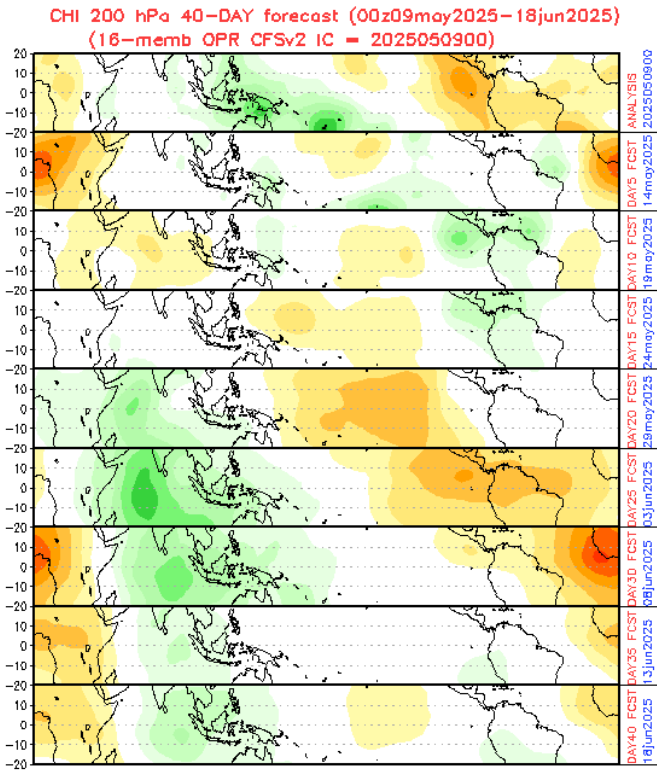
40-day MJO forecast. Source: https://www.cpc.ncep.noaa.gov/products/people/wd52qz/mjo/chi/cfs.gif
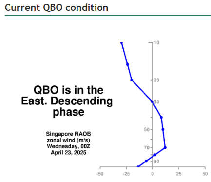
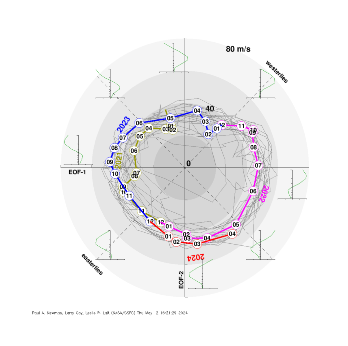
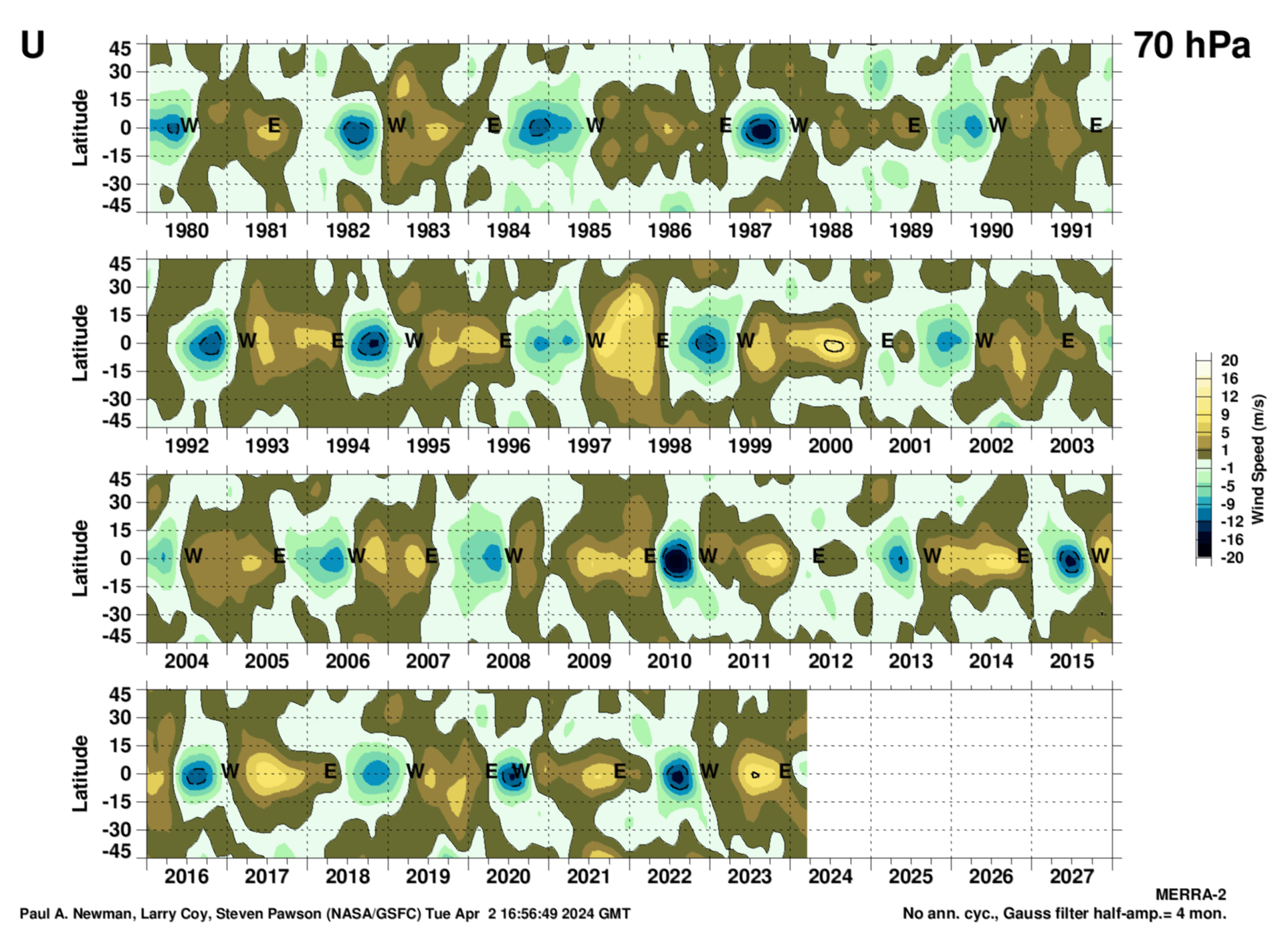
13. QBO shifting from W to E phase
More support for meridional airflow conditions, thanks to a slow, gradual shift from Westerly to Easterly phase is expected in 2025.
For South America it means more easterly tropical winds as westerly.
Downward motion of the easterlies is usually more irregular than that of the westerlies.
14. PNA-
PNA will be similarly, than its South-American equivalent, PSA in negative phase.
For better result, we will say more about PSA effect on Australian weather in the next part of the article.
Evolution of PDO index. Source: https://www.cpc.ncep.noaa.gov/products/precip/CWlink/pna/norm.pna.monthly.b5001.current.ascii.table
PDO forecast. Source: https://climateimpactcompany.com/february-2025-enso-pdo-amo-and-iod-outlook-2-2/
15. PSA (The Pacific South American Pattern)
In these months, the Pacific–South American (PSA) pattern is an important atmospheric teleconnection influencing climate variability in the Southern Hemisphere.
The PSA pattern is characterized by a sequence of high and low-pressure systems extending from the South Pacific into South America.
This pattern influences the jet stream and storm tracks, thereby affecting regional climate conditions.
Current, PSA- phase (a negative phase of PSA), is linked with La Nina, PDO- and IOD-, therefore, with storm activity in Australia and Western Pacific.
PSA is influenced by MJO by modulating of tropical convection, too.
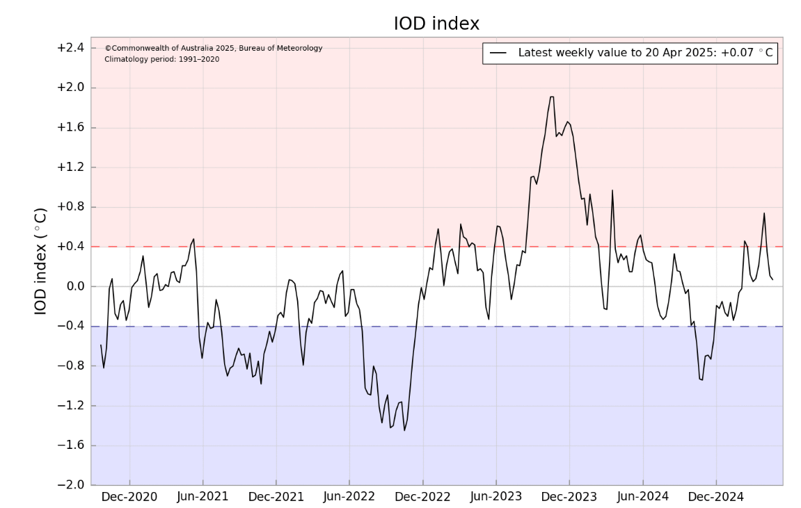
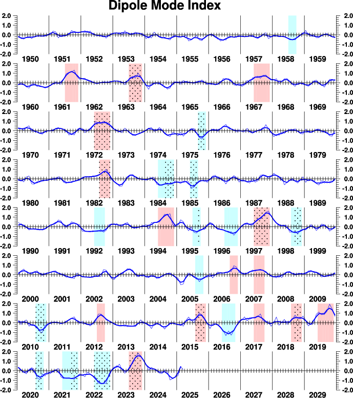
16. IOD-
The Indian Ocean Dipole (IOD) is defined by the difference in sea surface temperatures between the eastern and western tropical Indian Ocean.
Mostly neutral or slightly negative IOD index during Summer 2025 is expected.
IOD- correlates with La Nina and NAO-, but too PDO- and PSA-, therefore, strong Cyclone activity and above-average rainfall in Australia, are expected.
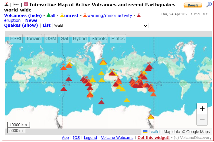
17. Volcanoes
Volcanoes across “The Ring of Fire” should have a local, maximally regional effect on temperature or cloudiness in Australia and Oceania in Winter 2025, in case of stronger eruptions, with higher VEI.
Similar or lesser effects of the possible very strong eruption on the weather in Australia and Oceania, especially through global temperature fluctuations.
18. Spider and mice season
La Nina, and other teleconnections (their negative phases), are favorable not only fertility of the lands and better harvest, but for spiders and mice, too.
Stormy years are bringing stronger spider season and mice season, especially from August to October every year, therefore, the end of Winter 2025 should show a nature blanketed by white spider nets, more than usual.
Mice, on the other hand, should cause harvest losses and damages, therefore stock your harvest carefully.
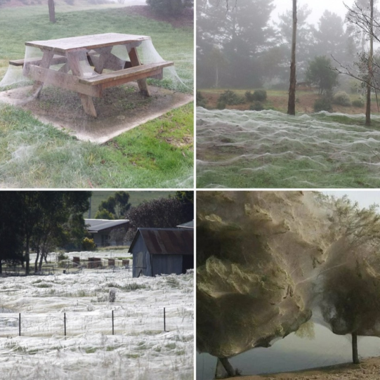
An illustration pictures for spider season. Source: https://www.instagram.com/p/DI3w2htIVW2/
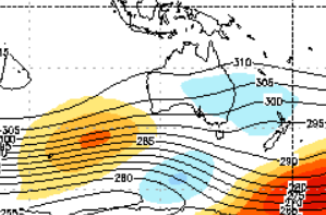
Now, we should look at the 6 main sectors on the forecast map for Winter 2025 for South, with similar regimes of weather:
A) TEMPERATURE NEUTRAL OR LOCALLY COLD AND VERY STORMY – (EASTERN REGIONS – BLUE): La Nina driven pattern, with PDO-, warm SSTs, IOD-, PSA-,…stormy, with low pressure anomaly, especially in the second half of the season, with severe storms, possible floods, landslides. Near storms on the North large hail, heavy rainfall, gusty winds or damaging lightning, on the South calmer, but still floody. Spider and mice season. Tmaxes up to +20/+30°C, Tmins +5/+10°C in the North, -5/-10°C in the South.
B) TEMPERATURE NEUTRAL OR SLIGHTLY ABOVE AVERAGE AND VERY STORMY, IN SOUTHERNMOST PARTS RARE SNOW (A CENTRAL THIRD OF THE CONTINENT, DARK GREEN): La Nina, etc. driven, still with storms, some heatwaves and less wildfires as usual, severe storms, some flash floods, spider, mice season. Southernmost parts with a rare snowfall (AAO neutral or negative). Tmaxes from +25°C on the South to +35°C above the continent, Tmins from -5°C on the South to +10°C on the North.
C) WARM AND STORMY, IN SOUTHERN PARTS, MAINLY IN THE SECOND HALF OF THE SEASON, BLIZZARDS (TASMANIA AND SE-MOST AUSTRALIA, WESTERN AUSTRALIA, NEW ZEALAND, PAPUA-NEW GUINEA, NEW CALEDONIA, VANUATU, SOLOMON ISLANDS – LIGHT GREEN): La Nina, etc. driven, still with storms, some heatwaves and wildfires in Western Australia, severe storms, some flash floods, spider, mice season. Southernmost parts with snowfall and blizzards (AAO neutral or negative, low pressure field, mainly in the second half of the season). Oceanian parts warm and stormy, New Zealand snowy during blizzards. Windstorms possible! Tmaxes from +10°C on the South to +35°C in equatorial regions. Tmins from -15°C on the South to +15°C on the North.
WARM (CENTRAL OCEANIA, ORANGE): Mostly warm pattern, average cyclone season, La Nina driven. Tmaxes up to +35°C, Tmins up to +15°C.
HOT NAD DRY (NORTHERN OCEANIA, RED): La Nina-driven pattern, despite warm seas, dry anomaly. Drought, wildfires possible. Lack of precipitation. Tmaxes +30/+35°C, Tmins +20/+15°C.
COLD AND DRY (FRENCH POLYNESIA REGION, LIGHT BLUE): Cold and dry thanks to La Nina (PDO-, IOD-, PSA-,…) and cold SSTs in Eastern Pacific. Stable weather. Tmaxes around +30°C, Tmins +20/+15°C.
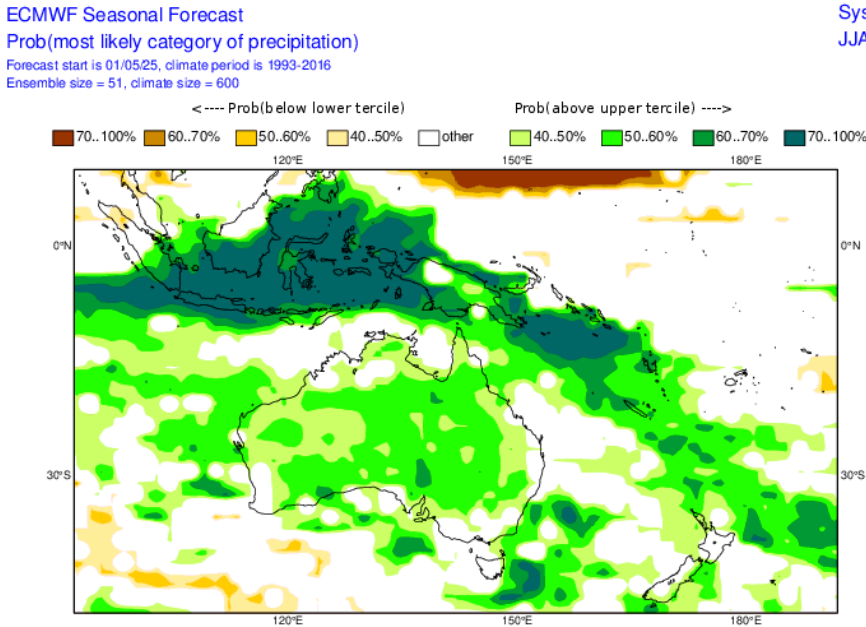
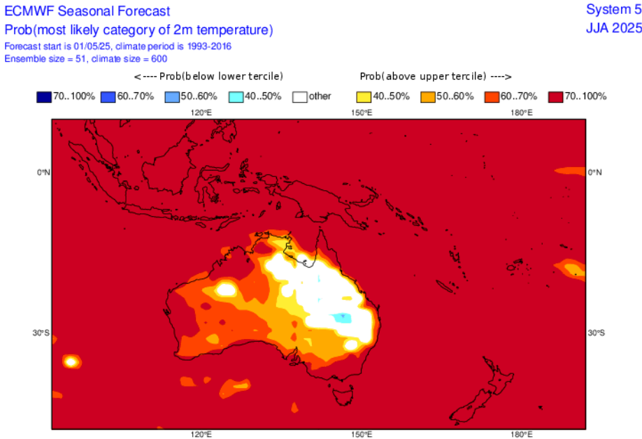
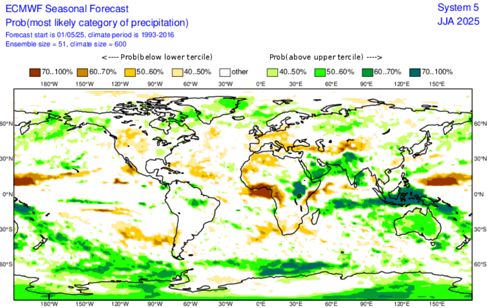
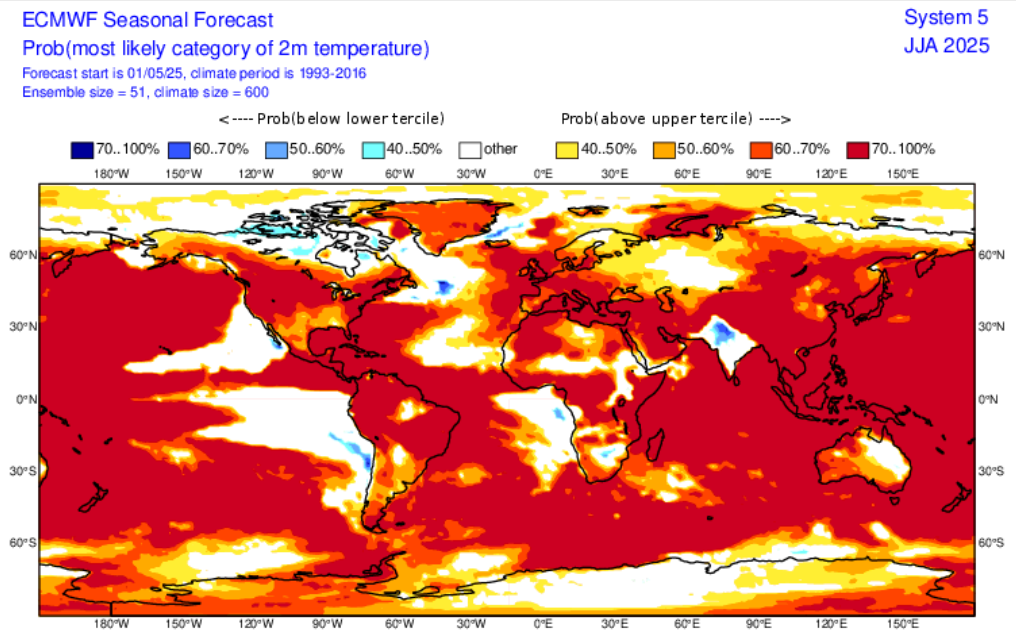
Precpipiation and temeprature forecasts for Australia and Oceania for Winter 2025 from ECMWF. Source: https://charts.ecmwf.int/?facets=%7B%22Product%20type%22%3A%5B%5D%2C%22Range%22%3A%5B%22Long%20%28Months%29%22%5D%2C%22Parameters%22%3A%5B%5D%2C%22Type%22%3A%5B%22Forecasts%22%5D%7D
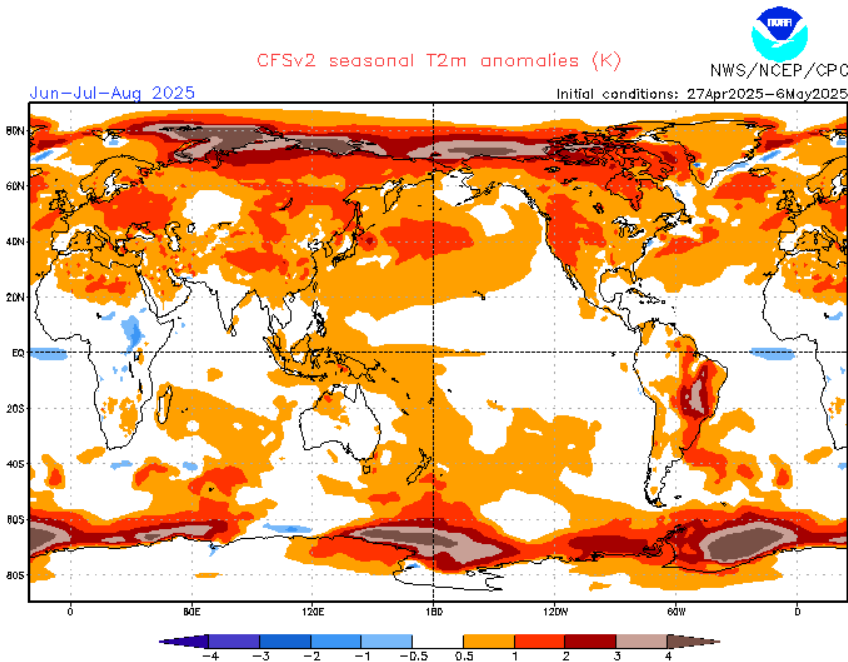
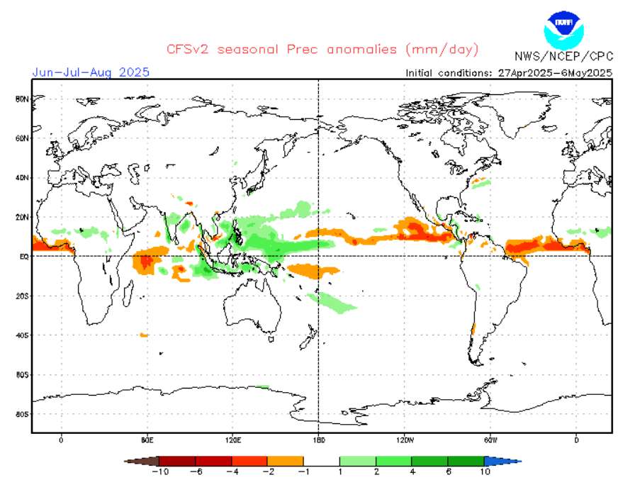
CFS forecast for Summer 2025. Source: https://www.cpc.ncep.noaa.gov/products/CFSv2/CFSv2_body.html
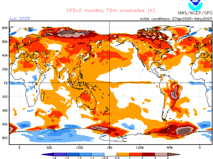
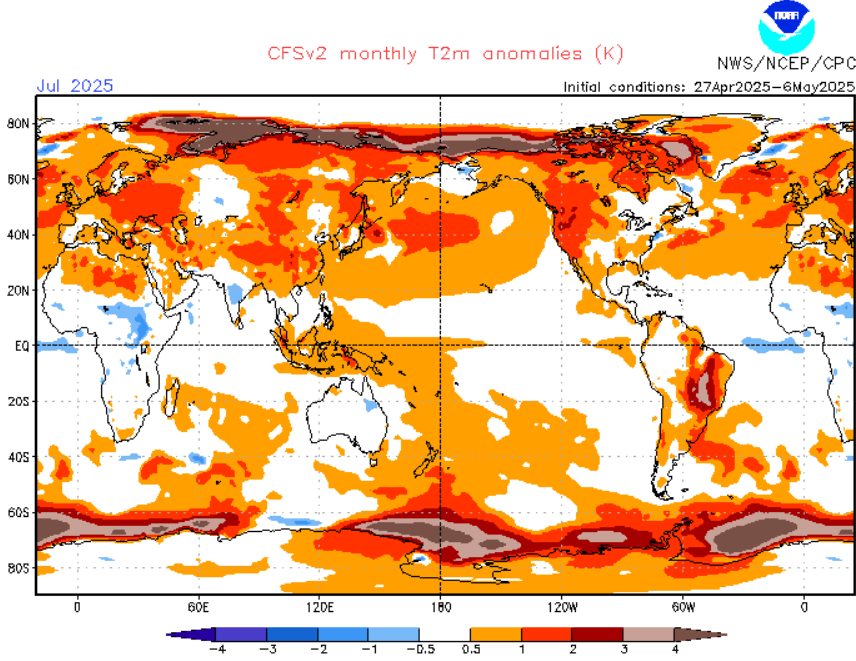
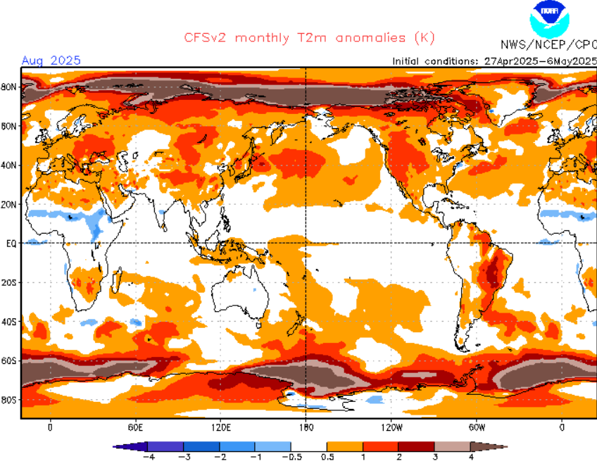
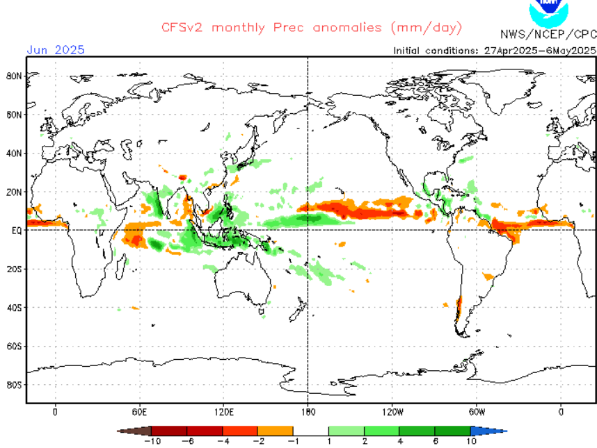
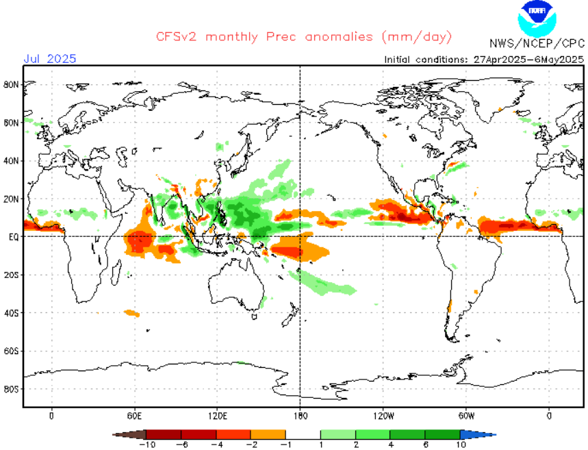
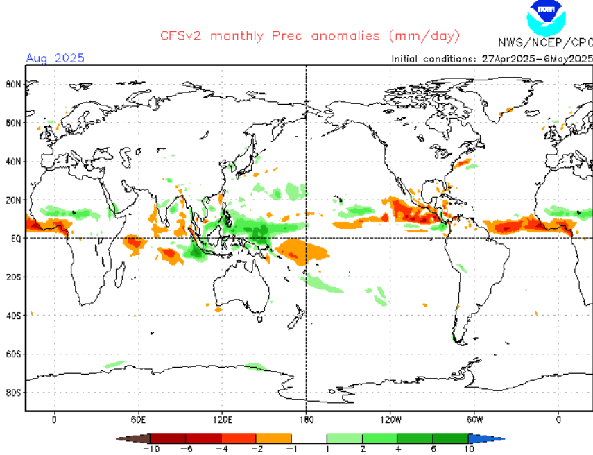
CFS forecast for Summer 2025 per months. Source: https://www.cpc.ncep.noaa.gov/products/CFSv2/CFSv2_body.html

Summer 2025 u200 – u850 in m/s. Source. https://www.cpc.ncep.noaa.gov/products/CFSv2/images3/glbudifSea.gif


12 thoughts on “WINTER 2025 FORECAST FOR AUSTRALIA AND OCEANIA: STORMY / SNOWY SEASON – STRONG CYCLONE, SPIDER, AND MICE LA NINA SEASON AHEAD”
Comments are closed.