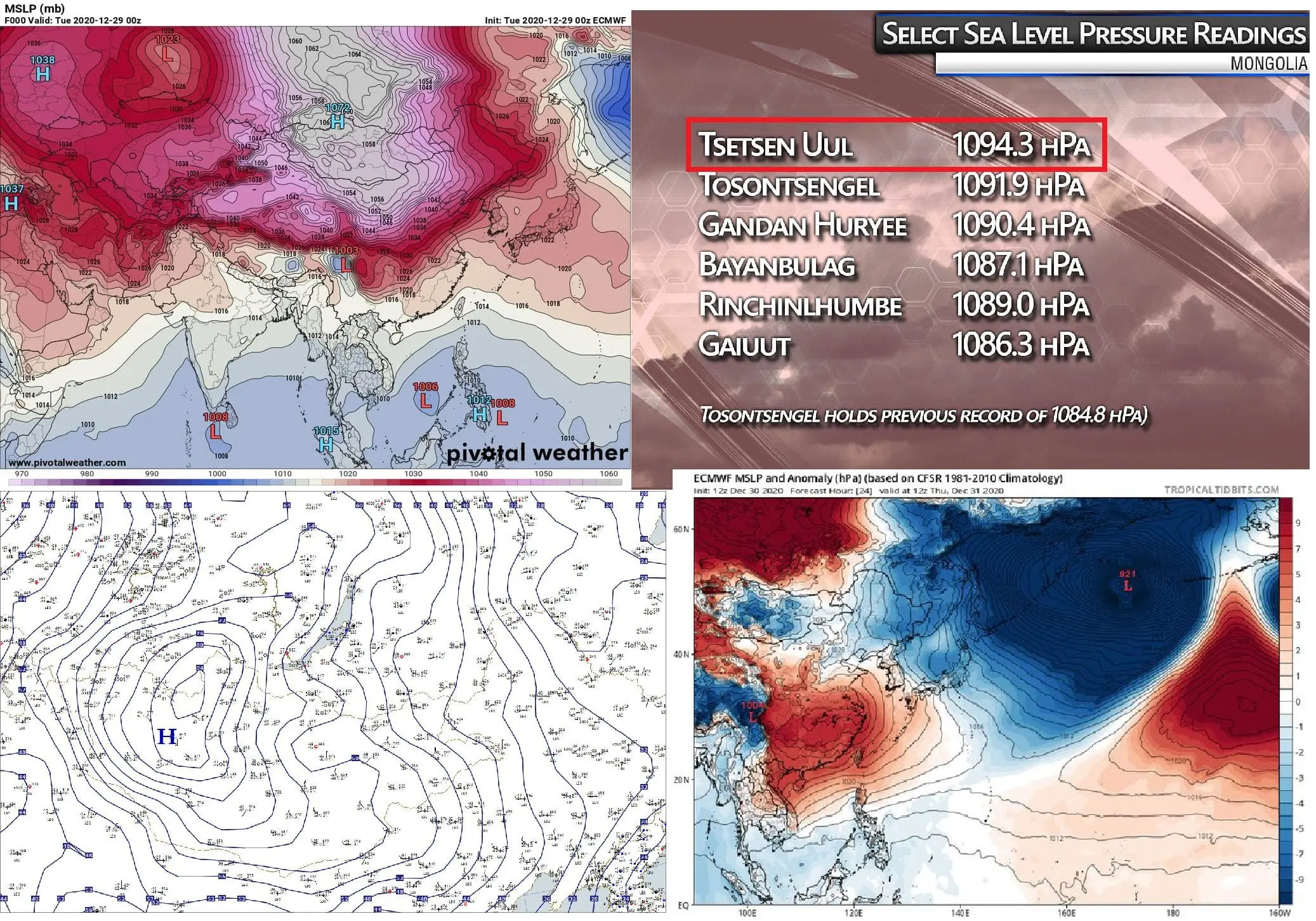
1094,3 hPA! Mongolia with the highest measured air pressure on Earth in history!
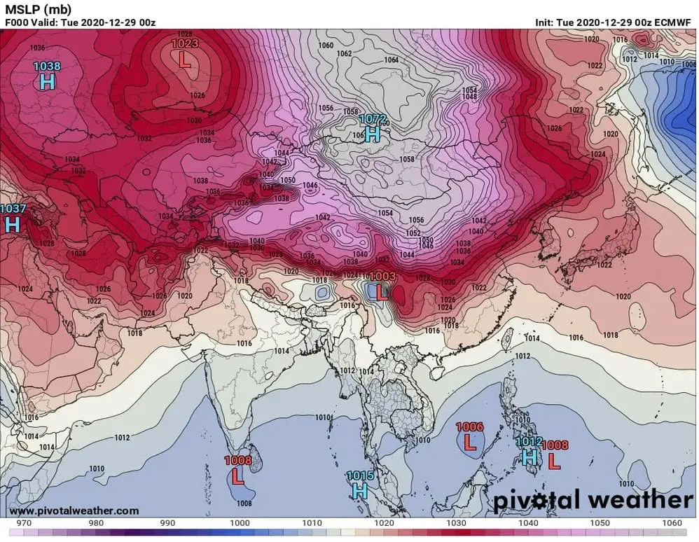
This blocking situation is really historic! During one of the coldest days in Siberia and Scandinavia in 3rd millennium occurred the highest measured air pressure in the Earth in all-time history, 1094,3 hPa! /https://mkweather.com/2021/01/01/peak-of-the-winter-in-europe-russia-and-scandinavia-50c-continental-europe-30c-and-british-islands-20c/; https://mkweather.com/2020/12/28/oymyakon-lowest-temperature-since-2002-572c-in-monstrous-pressure-high-1076-hpa/; https://mkweather.com/2020/12/29/siberian-blocking-extreme-cold-air-in-norway-433c-finland-411c-only-week-after-all-time-december-scandinavian-record-18c//.
An automatic weather station in Tsetsen-Uul, recorded an average pressure above sea level of 1094,3hPa, near very rigid temperature of -45,5°C on 29. December 2020. It should exceed the previous record of 1089,4hPa, from Mongolia, 30. December 2004.
Thanks to Arctic Amplification and rising area of snow cover in Northern Hemisphere during autumn and early winter (climate change), Siberian high has a tendency create stronger high-pressure blocking patterns in southern latitudes, with results of similar blocking situation such we experience with this period.
Temperature extremes in Eurasian continent, which we have described in last articles (Oymyakon -57,5°C, Norway -43,5°C, Finland -41,4°C – the strongest frosts since 1995 – 2002, parts of western Siberia with temperatures up to -53°C) and which we will describe in next articles (Beijing -26°C – the strongest frosts since 1978) are not only coincidence in chaotic climatic system – they are linked with current anomalous circulation above all Northern Hemisphere /https://mkweather.com/2020/12/29/updated-ecmwf-6-week-forecast-for-the-world-absolute-peak-of-the-winter-2020-21-in-continental-europe-around-15-january-after-decline-of-naoi-below-2-aoi-below-4//.
These days, we should watch not only the highest winter continental high pressure system development ever (Tsetsen Uul, Mongolia 1094,3 hPa), but too extremely deep Aleutian low – the deepest extratropical cyclone ever in northern Pacific /around 920 hPa around a New Year/).
A combination of these extreme pressure anomalies should significantly effect a character of incoming weeks and months, with possible extreme coldwaves in the USA and Canada soon, and strengthening of a blocking character of weather worldwide, with anomalous cold blasts across regions of Northern Hemisphere including Europe, Middle East or northern Africa (not only Asian and North American phenomena).
Already during next 2-3 weeks, Mkweather expects extreme Siberian cold blast in Europe /https://mkweather.com/2021/01/01/peak-of-the-winter-in-europe-russia-and-scandinavia-50c-continental-europe-30c-and-british-islands-20c// – Siberian air will be shifted from the center of mega-pressure high over Asia not only eastward – over the USA and Canada, but to westward, over Europe, with possible extreme surprise in the middle of Winter 2020/2021 for Europeans.
After extreme SSW associated with untraditional blocking character, should in late winter appear anomalous early spring conditions (late January, February, March 2021), therefore, we should be very surprise with changes of temperatures during next weeks in Europe, North America, Asia and northern Africa /https://mkweather.com/2020/12/29/in-2021-spring-come-earlier//. This circulation should later, during the advanced spring 2021, produce next unstable weather conditions, with late coldwaves and dangerous late frosts. Forecast for Spring 2021 for continents Mkweather will publish during January and February 2021.