38°C (101°F) behind polar circle in Siberia 5 years after unprecedent event with +40°C (104°F) in Nunavut (northern Canada)
Northern latitudes are changing dramatically during recent years under heavy pressure of climate change. It has warmed in the Arctic since 1900 by 10°C and warming trend is continuing very quickly, with many unprecedent or abnormal events in northern territories. On the other hand, in tropical latitudes has warmed only by 0,5°C or regionally even has cooled. Meridional temperature and pressure gradient between Arctic and tropical zone is weakening, what causing meandering Rossby planetary waves and jet-stream, what is linked with increased extreme events occurence such as heatwaves, drought or floods. Coldwaves are too more strong such as had to be, because waves of jet-stream are more curved and while to northern regions is advecting extremely hot and dry air, on other side of planetary wave flows very cold and humid air far away to the south. Verkhoyansk and other extreme heatwaves are an example of this anomalous flow above whole Northern hemisphere, with which we could rate in the next decades more and more often.

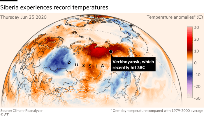
In the northest city in the world, Verkhoyansk, behind polar circle, in northeastern coast of Siberia, was 20. June 2020 reached anomalous temperature, +38°C / 101°F. In city, where is temperature average in June only +19°C it was for local inhabitants relatively positive experience. City is situated behind polar circle and it is known such as the northest city in the world, with population around 1,300.
Anomalous flow above Siberia in second half of June 2020 caused, that while to western half of Siberia flew very cold air, e.g. with heavy rain an temperatures only +3/+7°C (37/45°F) in Pechora, on other side of Rossby wave flew extremely hot and continental air from southeast, with reaching +31/+36°C (88/97°F) in many parts of northeast Siberia, in Verkhoyansk up to +38,0°C (101°F). While station Izvestij Tsik on the island on the west of Taymyr peinsula in the same time reported -1/+2°C (30/36°F) and 11 centimeters of snow, northeast Siberia was plagued by extensive summer fires. From 18. to 28. June hit Verkhoyansk together 11 tropical days in a row, with temperatures +30/+38°C (86/101°F), during 8 days in period +34/+38°C (93/101°F).
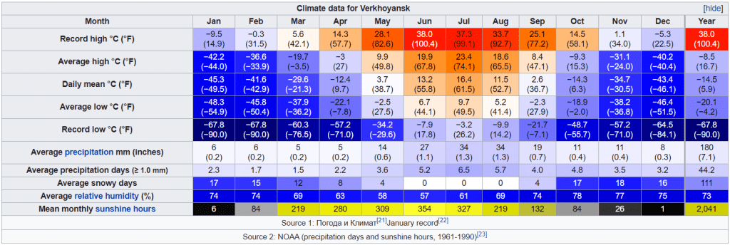
During winter, temperatures in the city are dropping up to -68°C (-90°F) and in January, never been more than -10°C (14°F). Summer is short and relatively warm, but with possible frosts up to -10°C. Climate is similar as in Yakutsk or Oymyakon, but little more oceanic. Behind polar circle is polar day and sunshine is pleasing inhabitants during all day. Sometimes thunderstorms appears, but precipitation is minimum, up to 20 mm in summer in average or 180 mm yearly in average.
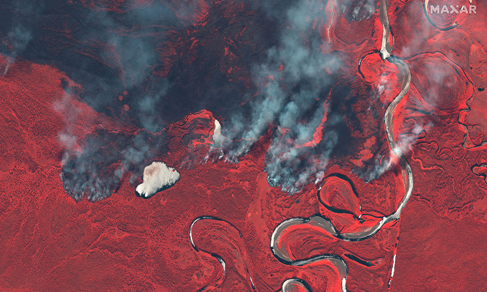
Immediately after start of hot and dry period in the region, tundra fires appers near Verkhoyansk. Extensive fires bother the Russian taiga and tundra every year, and situation is year-to-year worse. In 2019, Siberian fires were linked with campaign “We are choking” and Russia must declare state of emergency during second half of summer. We will see, how season 2020 will be. But it started very bad.

5 years ago +40°C (104°F) in Arviat, capital city of Nunavut, in 2019, recorded +45°C in France
Similar situation as in June 2020 in NE Siberia appeared in Canada 5 years ago. One from the coldest region in the Earth, Eskimo province Nunavut in Canada alived abnormal heat. Previous temperature record in its capital city, Arviat, was +33,9°C and for all province +34,9°C from Kugluktuk. But this time, again in the early summer, at the end of June 2015, was reached temperature anomalous +40,0°C in the Nunavut capital, so the previous temperature record was broken by unbelievable 5-6 degrees Celsius.
In summer 2019, again in France meteorologist measured +45°C in first, and +43°C in Paris in second heatwave. Temperatures above +40°C last summer hit Belgium, Netherlands, Switzerland and Germany too.
Exactly events such this points, that with climate something is wrong and shows exactly to Arctic amplification and Arctic warming potential to the next decades.
This year except of heatwaves in Siberia were interesting heatwaves in Canada, for now, with exceeding +40°C (104°F) in many parts northern from Great Lakes, and actually, recordly heatwaves bothering southeast of US /https://weather.com/forecast/national/news/2020-07-10-record-heat-southwest-southern-plains-expands?cm_ven=hp-slot-2; https://www.accuweather.com/en/weather-forecasts/sweltering-heat-to-engulf-west-southern-plains-by-midweek/775524/, with expecting +49°C (120°F) in Death Valley during next days. On the other hand, New York hit tropical storm Fay, with regionally rainfall records these days /https://www.accuweather.com/en/weather-news/historic-fay-makes-landfall-24-hours-after-forming/774962/.
June in Europe was rainy and floody, and in moderate zones was till these days more clouds and rain such an average – very probably linked with La-niňa phase and dropping stormtrack to southern regions for this reason (El-niňo and Godzilla El-niňo phases are linked more with AO+ and NAO+ with northern shifts of stormtrack and promoting of Hawai and Azore highs). In Europe, however, we are expecting a peak of summer in long-term forecast and our next article will investigate about it very soon.


