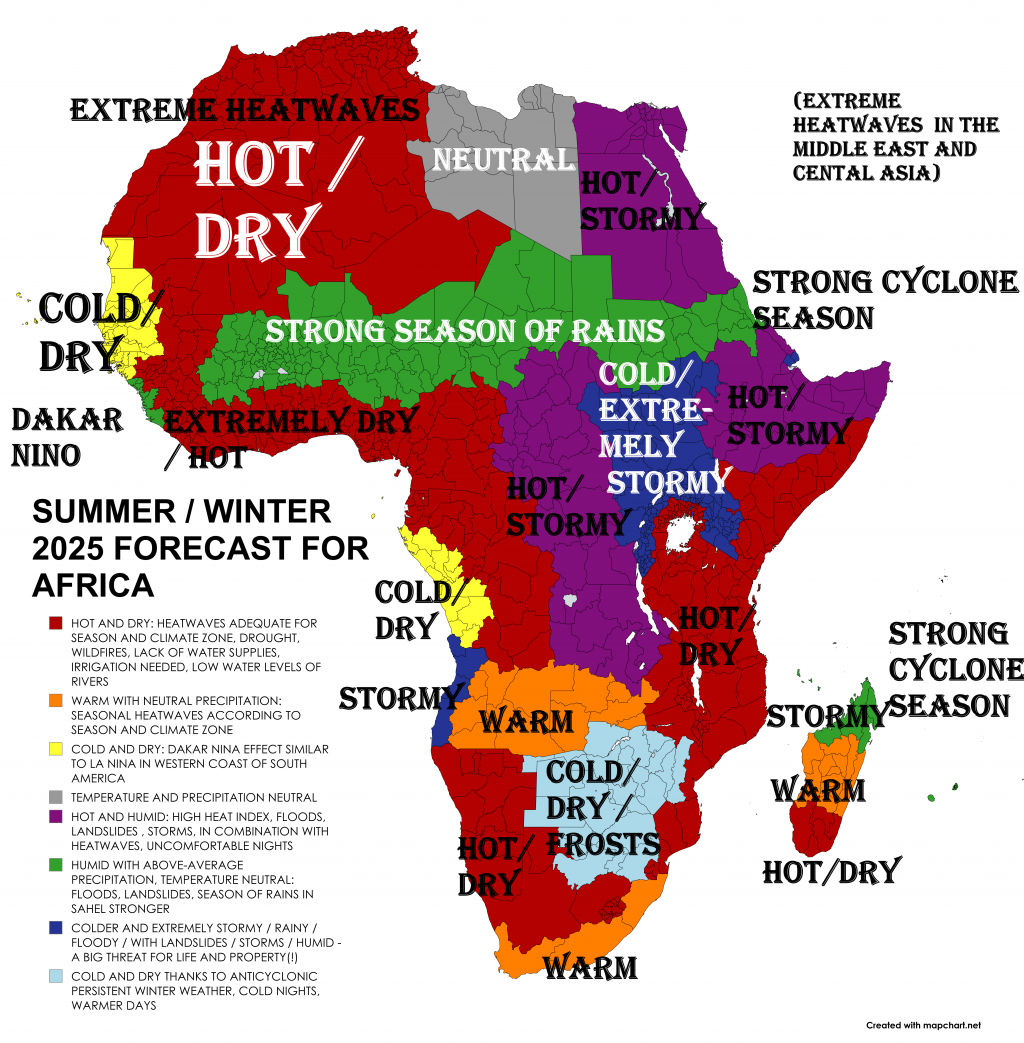
SUMMER / WINTER 2025 FORECAST FOR AFRICA: HOT, STORMY SEASON OF RAIN IN SAHEL / CENTRAL AFRICA, ANTICYCLONIC WINTER ON THE SOUTH
Summer / Winter 2025 is here, and Mkweather (mkweather.com) is bringing the first continental updates of seasonal forecasts for Europe /Europe//, North America /North America//, and /Asia/ for Summer 2025, Africa for Winter and Summer 2025, Australia /Australia/, South America /South America/, and Antarctica for Winter 2025.
This article will look at the forecast Summer and Winter 2025 conditions in Africa.
Sahara Region:
Countries like Algeria, Libya, Egypt, Mali, Niger, and Chad will face extreme heatwaves, with temperatures possibly reaching 50°C. This intense heat will be linked with dryness and heat stress in these desert areas.
Sahel Zone:
This semi-arid region south of the Sahara includes countries such as Senegal, Mauritania, Burkina Faso, Niger, Mali, Chad, Sudan, and Eritrea. The forecast predicts a hot and stormy rainy season here.
These factors will likely cause above-average rainfall and stronger storms, improving water availability but raising flood risks.
Central Africa:
Central-African region also expected to see increased rainfall and storm activity during the summer months. This can support vegetation growth but may also increase flood events.
Southern Africa:
Countries such as South Africa, Namibia, Botswana, Zimbabwe, Mozambique, Zambia, and Angola are forecasted to experience an anticyclonic winter. This means:
- Dominance of high-pressure systems leading to stable, dry, and cooler weather.
- Suppressed cloud formation and reduced rainfall.
These conditions will heighten drought risk, impacting agriculture, water supplies, and natural ecosystems.
East Africa:
Countries like Kenya, Uganda, Tanzania, Ethiopia, and Somalia are expected to have mostly dry conditions in early summer but will experience a brief wet period in the last 10 days of June 2025. This short rainy spell may provide temporary drought relief but is not expected to bring sustained rainfall.
Summary
- Extreme heatwaves in Sahara countries (Algeria, Libya, Egypt, Mali, Niger, Chad).
- Hot, stormy rainy season with above-average precipitation in Sahel and Central Africa.
- Dry, cool anticyclonic winter in Southern Africa (South Africa, Namibia, Botswana).
- Short wet spell in East Africa (Kenya, Tanzania, Ethiopia) late June, but overall, drought in southern and stormy season in northern East Africa.

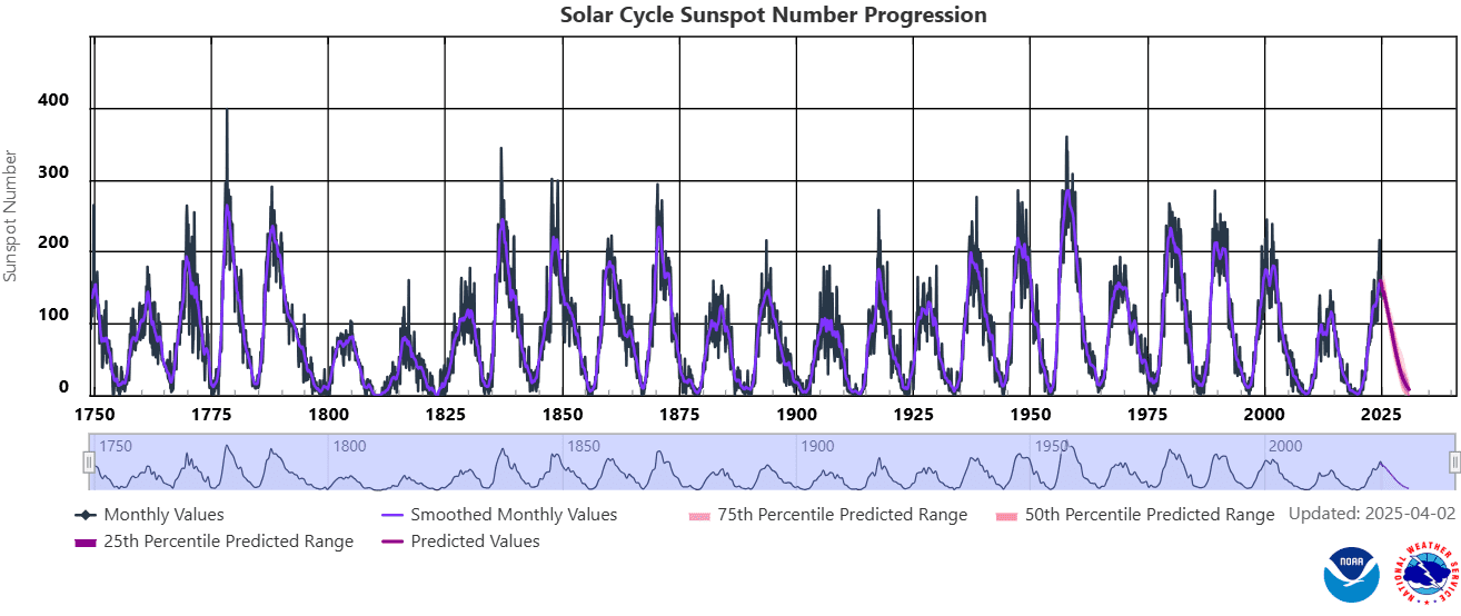
1. Sun cycle
Surprisingly strong solar activity during the peak of the current 25th solar cycle in the last years was associated with a strong phase of La Nina in its coming phase, it means from spring 2020 to spring 2023 (together 3 years of La-Nina driven climate anomalies around the Earth) and a short, but strong El-Nino in its peaking phase from Spring 2023 to Summer 2024. Now we are again in La Nina phase, but relatively weak La Nina, with a decrease of sunspots and geomagnetic storms, it means yearly lower chances for NAO+, mainly in the winter. In the Little Ice Age, a weak Sun activity produced Godzilla El-Ninos and strong AO- and NAO- patterns across the Northern Hemisphere with a result in hunger, bad harvests, diseases, fear, and finally, an inquisition. A peak of the strong solar activity was observed between 1950 – 2000, and from then, activity was decreasing, however, the last cycle was observed surprising increase of the Sun activity, with surprising events in the first half of 2024.
From 21. to 22. February 2024 there was a big chance, that the Sun produced the strognest Triple-eruption in 24-hours In the last 30 years, maybe since 1900, maybe since pre-Middle age times (Middle ages hadn´t strong Sun stroms). There have been 3 Triple-eruptions in the last 20 years:
2013: weaker intensity 5/13/2013 2:17 N11E89 X1.75/13/2013 16:01 N11E85 X2.85/14/2013 1:11 N08E77 X3.2.
2014: weaker intensity 6/10/2014 11:44 6/10/2014 11:42 S15E80 X2.26/10/2014 13:03 6/10/2014 12:52 S17E82 X1.56/11/2014 9:10 6/11/2014 9:06 S18E65 X1.0.
2017: main eruption stronger, but 24-hour criterion not met9/6/2017 9:17 9/6/2017 9:10 S08W32 X2.29/6/2017 12:10 9/6/2017 12:02 S09W34 X9.39/7/2017 14:55 9/7/2017 14:36 S11W49 X1.3.
Year 2003 brought 2 giant eruptions, but again only 2 in 24 hours and not 3, does not meet criteria (https://sos.noaa.gov/catalog/datasets/sun-historical-solar-flare-2003/).
Previously the solar cycle peaked between 1989-1992: “The next 14 days produced 11 “X class” flares” March 1989: The largest geomagnetic storm in the 20th century: (https://agupubs.onlinelibrary.wiley.com/…/2019SW002278).
But even the strongest storm in 100 years did not produce 3 X ray bursts in 24 hours: (https://agupubs.onlinelibrary.wiley.com/…/swe20919-fig).
Stronger solar cycles occurred 3 more times from the 1950s to the 1970s, but we don’t know if there was a triple burst. If not, it may be the strongest triple burst since before the Middle Ages, when solar activity was at a strong minimum. Database: https://xrt.cfa.harvard.edu/flare_catalog/all_full.html.
The strongest geomagnetic storm in 21. century? The strongest since 1960 and the second strongest in 100 years? According to estimates of the daily Ap index for 11.5.2024, Ap 274 was measured (note: current Spaceweather data contains a number 271), which should be the second strongest X-ray attack on our bodies in 24 hours in almost 100 years (since 1932) (in modern history)! Stronger was only 1960 with Ap 280. If we overcame single days in the years 1989 and 2003, it will be the strongest geomagnetic storm since 1960 (in 64 years), which is a once-in-a-lifetime event. Moreover, weakening of solar cycles in 21. century is mostly expected, which should mean that this should be the strongest geomagnetic storm in 21. century! https://www.spaceweatherlive.com/…/top-50-geomagnetic…https://www.spaceweather.gov/…/aurora-dashboard….
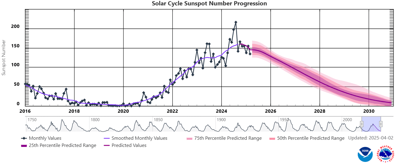
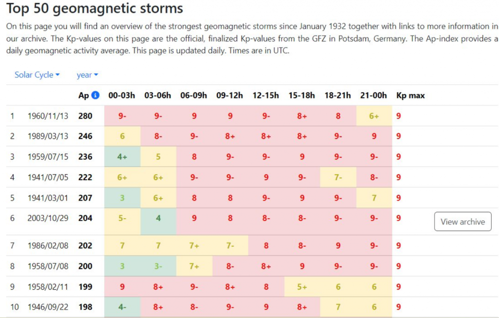
The strongest 24-hour geomagnetic storms until 11. May 2024 (placed in second place) /Source: spaceweather.com
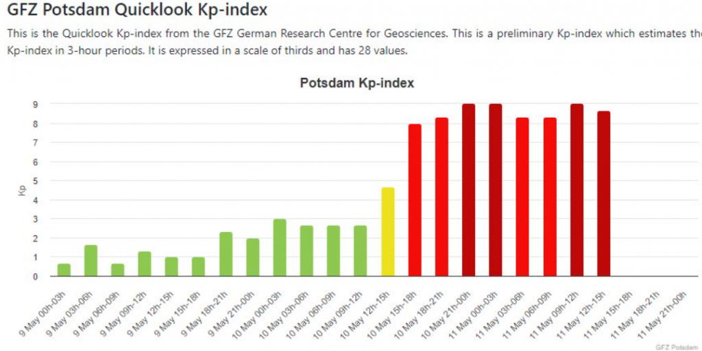
Source: https://kp.gfz.de/en/hp30-hp60
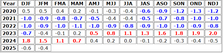
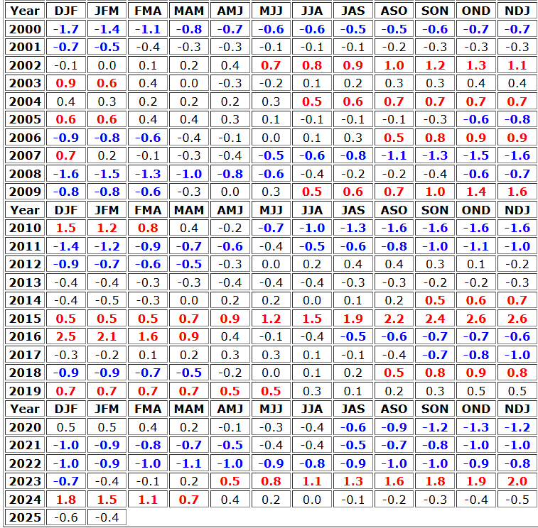
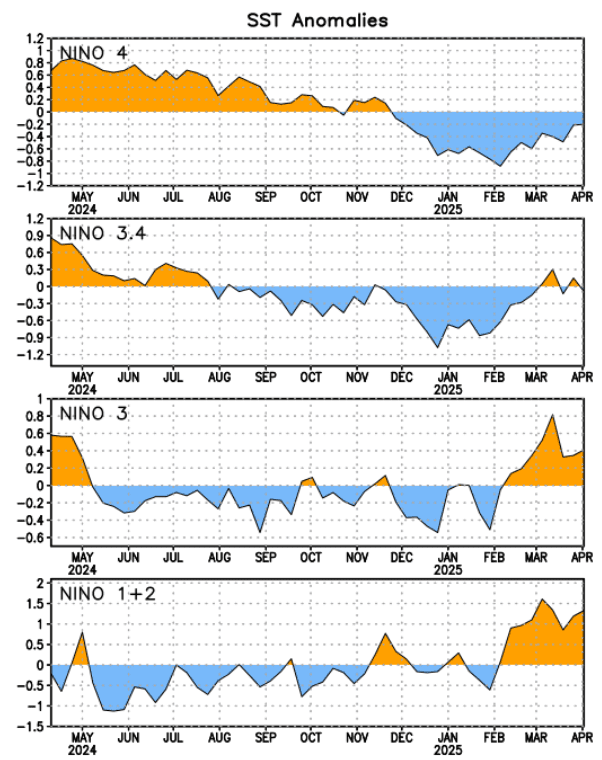
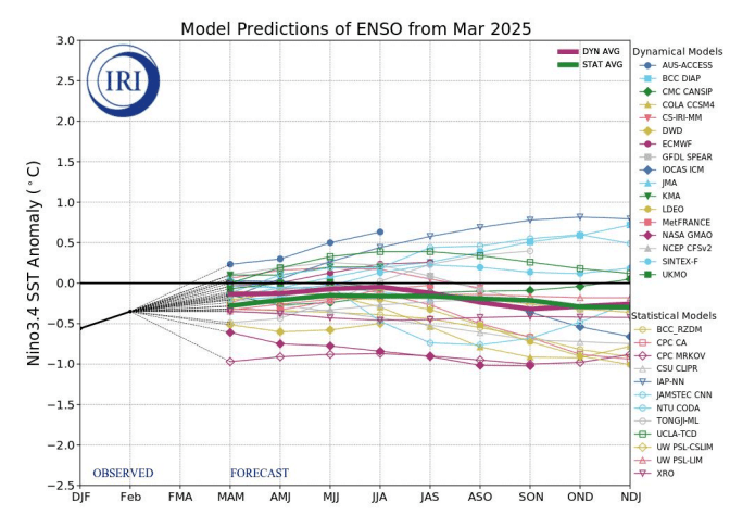
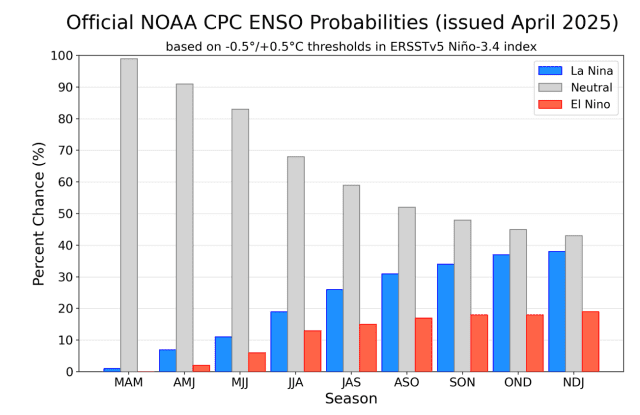
2. Probable strengthening La Nina
During Winter 2025 a shift from neutral phase to weaker La Nina pattern is predicted.
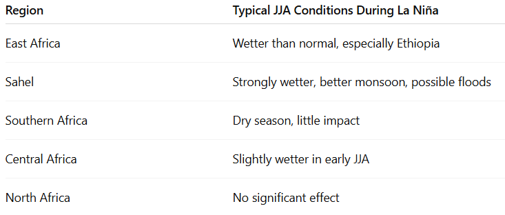
During the June–July–August (JJA) period, La Niña has varied impacts across Africa, strongly influenced by regional climates and prevailing seasonal patterns. In East Africa, particularly in Ethiopia and parts of South Sudan, La Niña typically enhances rainfall by strengthening the Indian Ocean monsoon and increasing moisture transport from the Arabian Sea. This results in wetter-than-average conditions during the region’s main rainy season, which is crucial for agriculture and water resources.
In the Sahel region—stretching from Senegal through Mali, Niger, northern Nigeria, and into Chad—La Niña has one of the most consistent and significant effects. It generally leads to a more active and northward-shifted Intertropical Convergence Zone (ITCZ), intensifying the West African Monsoon. This brings increased rainfall, longer rainy seasons, and improved agricultural prospects, though it can also raise the risk of flooding and crop damage.
In contrast, Southern Africa, including countries like Botswana, Namibia, Zimbabwe, and South Africa, experiences its dry season during JJA. Therefore, La Niña has minimal direct impact during this period. However, it may subtly influence temperature patterns, with some areas experiencing slightly cooler conditions than usual.
Central Africa, dominated by the Congo Basin, transitions toward a brief dry spell in JJA. La Niña can sometimes delay this transition, leading to slightly extended wet conditions early in the season, but overall impacts here are less consistent and harder to predict.
Meanwhile, North Africa, which includes arid regions such as Egypt, Libya, and Algeria, typically remains hot and dry in summer, with little to no influence from La Niña on precipitation or temperature patterns during JJA.
In summary, La Niña in JJA brings increased rainfall to East Africa and the Sahel, minimal effects to Southern Africa and Central Africa, and virtually no impact on North Africa.
La Nina weather patterns for JJA in Africa.
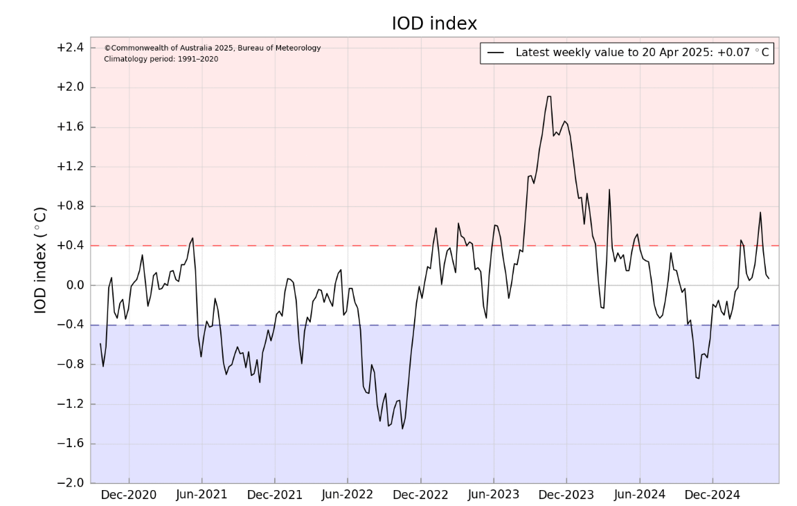
2. IOD-
During JJA, a negative Indian Ocean Dipole (IOD−) causes cooler waters near East Africa and warmer waters near Indonesia, shifting rainfall eastward and weakening the monsoon over East Africa. This results in drier-than-normal conditions in Ethiopia, Kenya, Somalia, and Tanzania, increasing the risk of drought. The Horn of Africa is especially vulnerable, often experiencing delayed or failed rains. The Sahel sees little to no direct impact, though slight drying may occur in the eastern parts. Southern and Central Africa are mostly in their dry season, so impacts are limited during JJA, though a developing IOD− may hint at wetter conditions in the following months. North Africa remains unaffected.
In fact, a stronger rainfall in northern East Africa and Sahel are expected, as during strong IOD- phases, which should be linked with other teleconnections, especially La Nina.
3. The East African Monsoon
The East African monsoon (mainly active in JJA) brings seasonal rains to Ethiopia, Kenya, Somalia, and South Sudan. During a negative IOD, cooler sea surface temperatures near East Africa reduce evaporation and moisture transport from the Indian Ocean. This weakens the monsoon flow and shifts convection toward Indonesia, leading to drier-than-normal conditions, weaker or delayed rains, and increased drought risk.
However, La Nina is contributing to wetter conditions in East Africa, with a result of rains in northern parts of the region in Summer / Winter 2025, while southern parts will remain dry.
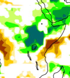
Forecast of East African monsoon for JJA 2025 – detail. Source. ECMWF
4. Shifts of the ITCZ and the monsoon season in the Sahel
The Sahel JJA monsoon is influenced by several key teleconnections. Warm tropical Atlantic sea surface temperatures (Atlantic Niño) enhance moist monsoon flow and increase rainfall. La Niña in the Pacific strengthens the monsoon, while El Niño tends to weaken it. The North Atlantic Oscillation (NAO) also affects Sahel rainfall, with positive NAO suppressing rains and negative NAO enhancing them. The Indian Ocean Dipole (IOD) has a weaker, less direct impact. The strength of the Saharan Heat Low (SHL) is crucial, as a stronger SHL intensifies moisture inflow and rainfall over the Sahel.
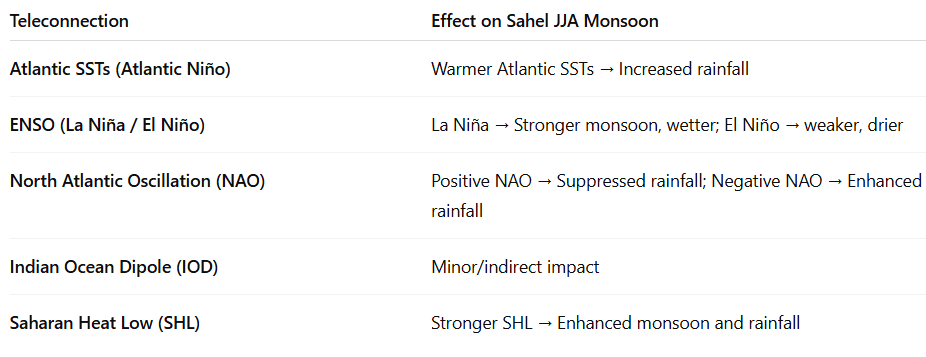
Table: Crucial teleconnections for the Season of rain above the Sahel.
4. AAO and Antarctica
The Antarctic Oscillation (AAO) influences South African winters by shifting the westerly wind belt. During a positive AAO phase, westerlies contract toward Antarctica, bringing cooler and wetter winters to southern South Africa. In a negative AAO phase, westerlies shift northward, causing warmer and drier winters in the region.
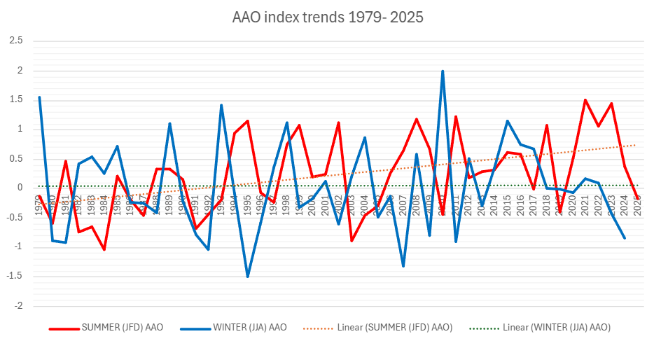
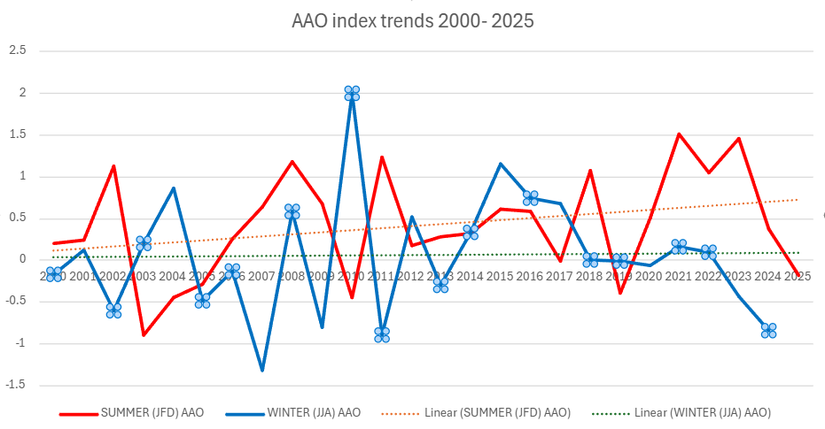
AAO index trends in summer and winter months. Source: https://www.cpc.ncep.noaa.gov/products/precip/CWlink/daily_ao_index/aao/monthly.aao.index.b79.current.ascii.table
5. A shift of Hadley Cell southward
Likewise in the Northern Hemisphere, in Southern Hemisphere is Hadley cell similarly shifted more soutward.
The shift is not so powerful, partly thanks to changes in Antarctica, and partly thanks to large area of cooling oceans in the Southern Hemisphere.
The shifted mid-latutidinal stormtrack should hit more southern regions in this changed climate. Rossby waves, however, should produce long pressure troughs with low-latitude situated lows and extreme high-latitude heatwaves on their front sides during a collapsing jet-stream.
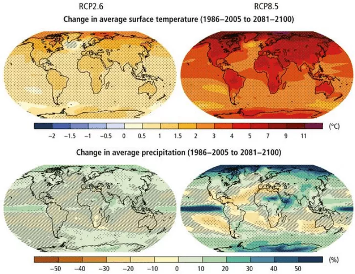
RCP8.5 (CMIP5) (IPCC, 2014). Note: precipitation changes in Europe are strongly linked with a shift of Hadley cell northward.
6. Strong (and deadly) Hurricane 2025 season
The northwestern coast of Africa should be hit already in Summer 2025 by early Atlantic hurricanes, especially Morocco, Western Sahara, Algeria and Tunisia, such as the Canary Islands.
Hurricane season will be stronger thanks to La Nina, PDO- and AMO+.
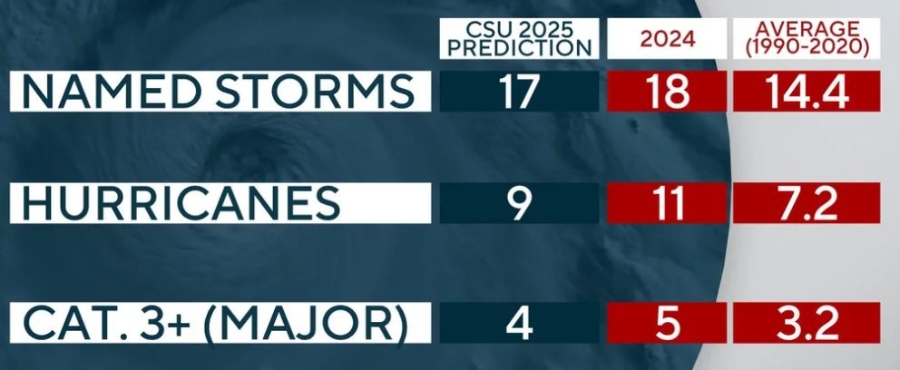
Source: https://www.cbsnews.com/news/2025-atlantic-hurricane-season-forecast/
7. Mostly AO- / NAO-
During JJA (June–August), the North Atlantic Oscillation (NAO) strongly influences West Africa and the Sahel. A positive NAO phase strengthens the Azores High and trade winds, which suppress moisture transport and lead to drier-than-normal conditions and reduced rainfall in the Sahel and parts of North Africa. Conversely, a negative NAO weakens these pressure systems, allowing more moist air to flow into the Sahel, often resulting in enhanced rainfall and better monsoon conditions.
The Arctic Oscillation (AO) mainly affects higher latitudes, but it can indirectly influence northern Africa’s weather. During a positive AO, the polar vortex is strong, keeping cold air confined to the Arctic and promoting warmer and drier conditions over North Africa in summer. A negative AO allows cold air to move southward, sometimes bringing cooler and wetter weather to North African regions.
Overall, these oscillations help modulate the strength and timing of the Sahelian monsoon and North African summer climate through their effects on atmospheric circulation and moisture availability.
In Summer 2025, more NAO- and AO- conditions are expected.
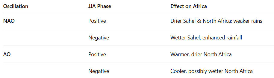
Effects of NAO / AO on JJA weather in Africa.
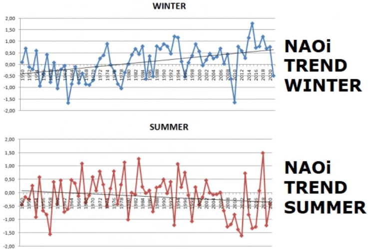
Average seasonal NAO index from daily data in the winter and summer. Source of data: https://www.cpc.ncep.noaa.gov/products/precip/CWlink/pna/norm.nao.monthly.b5001.current.ascii.table
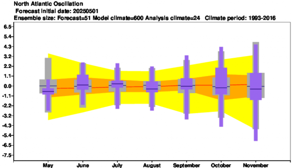
NAO forecast until October 2025 /Source: https://charts.ecmwf.int/products/seasonal_system5_climagrams_teleconnection?base_time=202504010000&index_type=NAE
8. AMO+
During a positive AMO phase (AMO+), the tropical North Atlantic Ocean experiences warmer-than-average sea surface temperatures over multidecadal periods. This warming generally enhances moisture transport and convection over West Africa, leading to a stronger and wetter Sahel monsoon during JJA. As a result, rainfall tends to increase in the Sahel and parts of the Guinean coast, improving agricultural conditions.
In addition, AMO+ can influence broader West African climate by strengthening the West African monsoon circulation and reducing drought frequency. However, its effects are modulated by other factors like ENSO and regional atmospheric patterns.
In Summer 2025 will be Sahel really above precipitation averages, but Guinea cost will remain hot and dry.
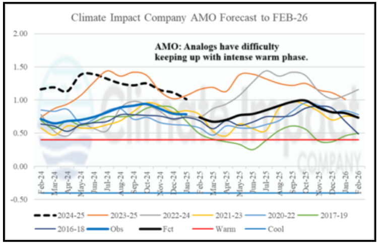
AMO outlook. Source: https://climateimpactcompany.com/february-2025-enso-pdo-amo-and-iod-outlook-2-2/
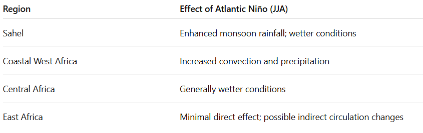
9. Atlantic Nino (Dakar Nino / Nina)
Atlantic Niño is characterized by warmer-than-normal sea surface temperatures in the eastern equatorial Atlantic, near the Gulf of Guinea. This warming increases evaporation and convection, enhancing moisture supply to the African continent.
During JJA (June–August), Atlantic Niño events typically strengthen the West African monsoon, resulting in:
- Increased rainfall over the Sahel and coastal West Africa, which helps reduce drought risk and supports agriculture.
- Enhanced moisture and convection in parts of Central Africa, often leading to wetter-than-average conditions.
- Limited direct impact on East Africa, though it may subtly influence regional circulation patterns.
The Atlantic Niño thus plays a key role in modulating seasonal rainfall variability in West Africa and the Sahel during summer.
Effect of possible Atlantic Nina in JJA 2025 should be only minor, cause Sahel and Central African precipitation will be above averages. There are not available data for expected conditions, but La Nina should correlate with Dakar Nina phases, with some time lags. Response of Dakar Nina on the expected La Nina phase should be delayed.
Dakar Nina and its effect on JJA weather in Africa.
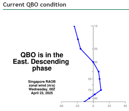
10. QBO shifting from W to E phase
The Quasi-Biennial Oscillation (QBO) is a regular oscillation of equatorial stratospheric winds between easterly and westerly phases, cycling roughly every 28 months. The QBO influences tropical convection and atmospheric circulation patterns, which can affect African climate.
- During the QBO westerly phase, convection and rainfall tend to increase over parts of tropical Africa, often strengthening the West African monsoon in JJA.
- During the QBO easterly phase, the monsoon can weaken, sometimes leading to drier conditions in the Sahel and surrounding regions.
The QBO’s effect on Africa is often modulated by other climate factors like ENSO and the Atlantic Ocean conditions.
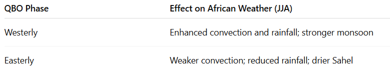
Recapitulation: QBO effects on JJA weather in Africa.
11. PDO-
The negative phase of the Pacific Decadal Oscillation (PDO−) is linked to cooler central and eastern North Pacific waters. During JJA, PDO− often correlates with drier conditions and weaker monsoon rains in the Sahel and West Africa. In East Africa, PDO− can sometimes enhance rainfall, while its impact on Southern Africa in JJA is minimal due to the dry season.
PDO- won´t be a main driver in Sahel, but should contribute to rainfall in north-East Africa.
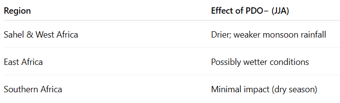
PDO- effects on Africa in JJA.
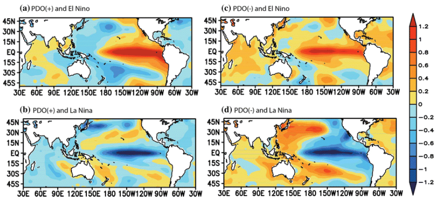
Warm SSTs during La Nina and PDO- above Asian seas. Source: https://www.researchgate.net/figure/Composites-of-SST-anomalies-during-a-the-warm-phase-of-the-PDO-and-El-Nino-years-b-the_fig3_283050507
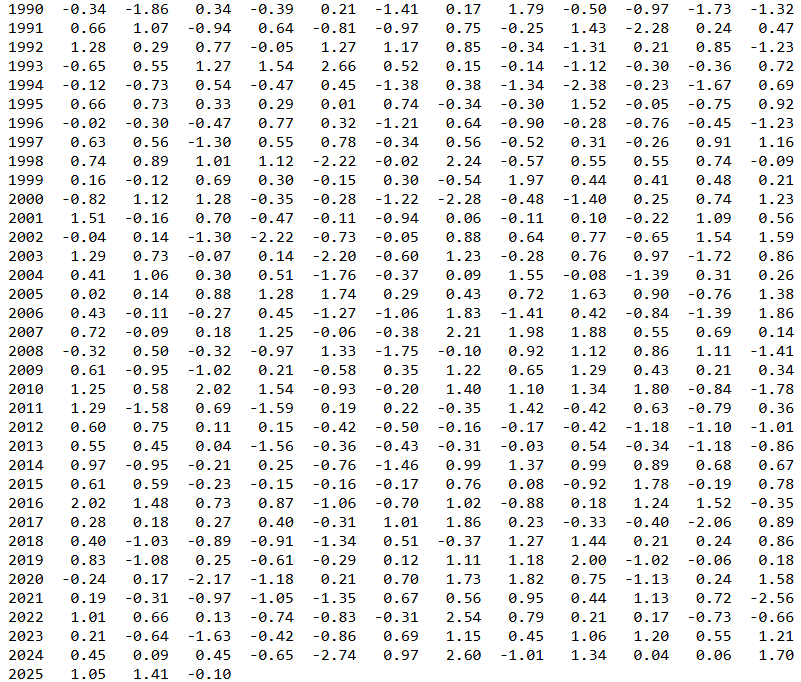
Evolution of PDO index. Source: https://www.cpc.ncep.noaa.gov/products/precip/CWlink/pna/norm.pna.monthly.b5001.current.ascii.table
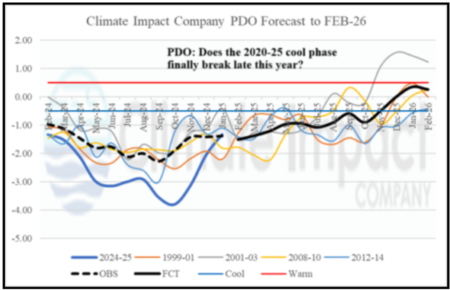
PDO forecast. Source: https://climateimpactcompany.com/february-2025-enso-pdo-amo-and-iod-outlook-2-2/
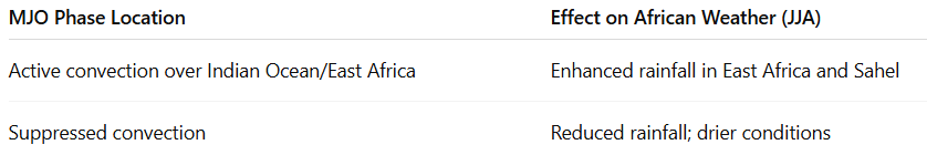
12. MJO
The Madden-Julian Oscillation (MJO) is a tropical wave cycling every 30–60 days, influencing rainfall in Africa during JJA. When the MJO’s active convection is over the Indian Ocean or East Africa, it brings enhanced rainfall to East Africa and sometimes the Sahel. During suppressed phases, these regions experience drier conditions.
Until 16. July 2025 will be MJO mostly in dry phase, with some wet period in the 3rd decade of June 2025, with better conditions for East-Africa convection.
Summary.
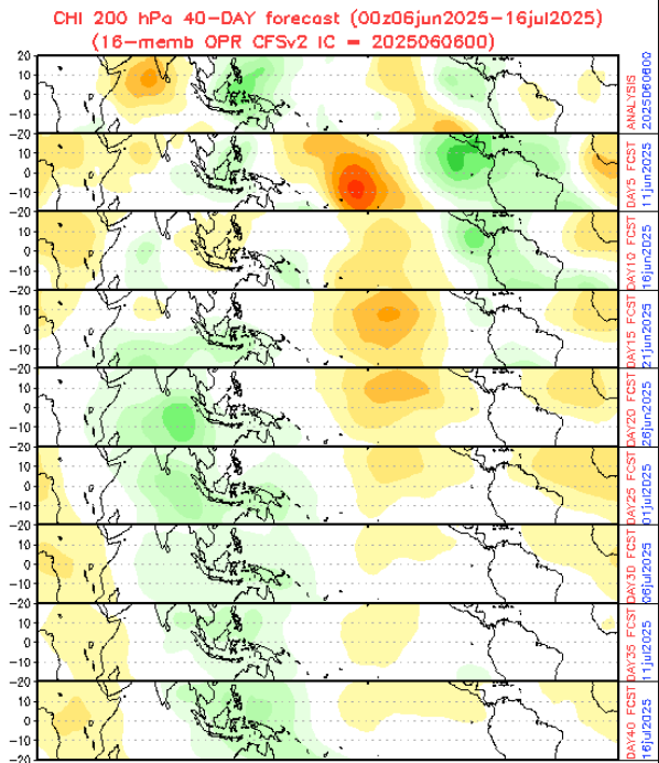
40-day MJO froecast. Source: https://www.cpc.ncep.noaa.gov/products/people/wd52qz/mjo/chi/cfs.gif
13. PNA-
The Pacific-North America (PNA) pattern is a major atmospheric teleconnection in the Northern Hemisphere. During its negative phase (PNA−), there is a ridge over the western US and a trough over the eastern US. Though primarily affecting North America, PNA− can influence global circulation patterns that impact Africa.
In Africa, PNA− is often linked to weaker West African monsoon rainfall during JJA, resulting in drier conditions in the Sahel and surrounding regions. This happens because PNA− tends to coincide with atmospheric patterns that suppress moisture transport into West Africa.
Evolution of PDO index. Source: https://www.cpc.ncep.noaa.gov/products/precip/CWlink/pna/norm.pna.monthly.b5001.current.ascii.table
PDO forecast. Source: https://climateimpactcompany.com/february-2025-enso-pdo-amo-and-iod-outlook-2-2/
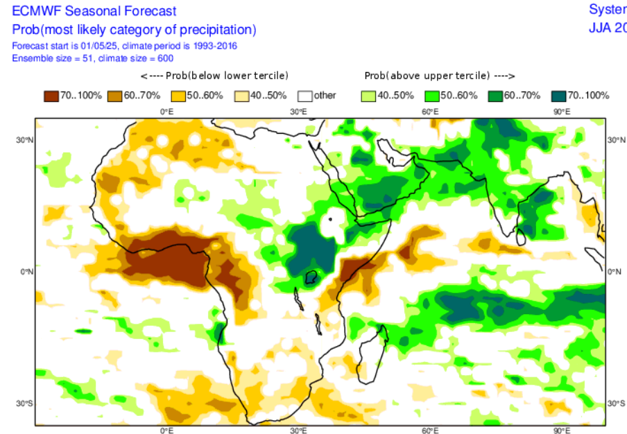
ECMWF JJA forecast for Africa. Source: https://charts.ecmwf.int/
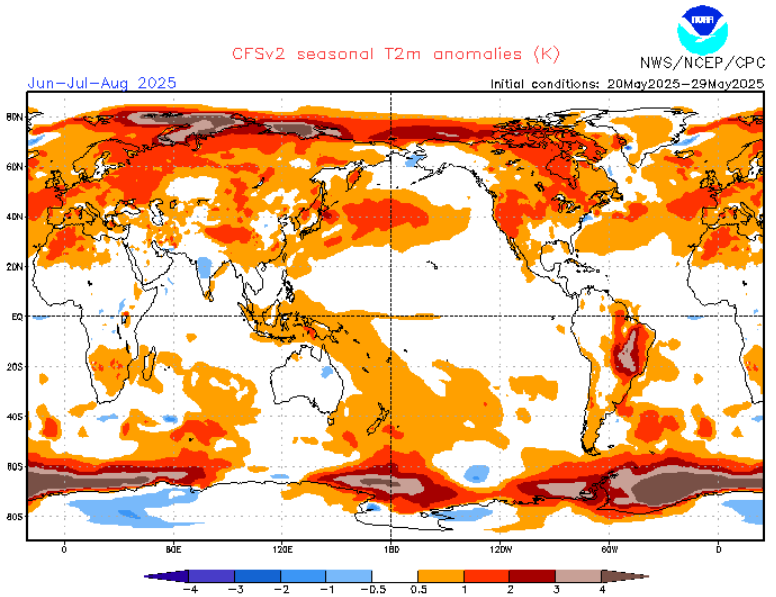
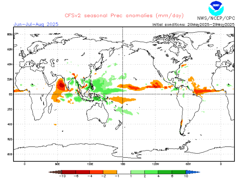
CFS forecast for JJA. Source: https://www.cpc.ncep.noaa.gov/products/CFSv2/CFSv2_body.html
14. PSA (The Pacific South American Pattern)
The Pacific South American (PSA) pattern influences southern Africa’s JJA climate by shifting mid-latitude circulation. The positive PSA phase brings cooler, wetter winters to southern Africa, while the negative phase causes warmer, drier conditions. Its effect on tropical Africa is minimal.
Dry winter in South Africa supports our earlier suggestions for PSA- phase in JJA 2025.
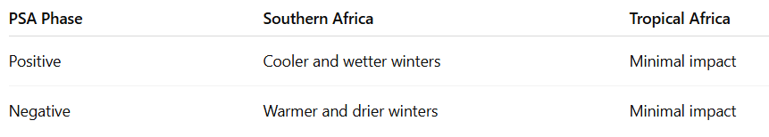
Summary.
16. Warm SSTs (Sea surface temperatures)
Mostly warm seas in eastern, northern and NW parts of continents are expected with colder anomalies in Guinea Bay, possibly leading to dry JJA season in the region westward and southward from Nigeria.
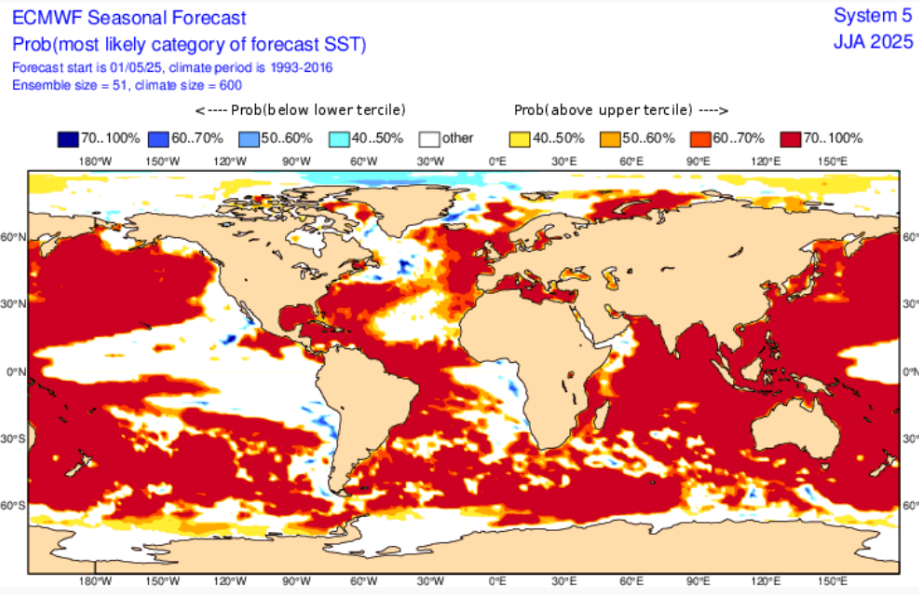
SSTs predicted in Summer 2025. Source: https://charts.ecmwf.int/products/seasonal_system5_standard_ssto?area=GLOB&base_time=202505010000&stats=tsum&valid_time=202506010000
17. Extremely hot Sahara
In the last year often anomalously hot Western Sahara, but hot Egypt, too were creating incredible sources of hot air for the Middle East and Central Asia.
In Summer 2025 this pattern, especially after historic heatwaves in the Middle East and Central Asia in April and May 2025, will be strengthened, with path of heatwaves with NEE direction, from Sahara to the northern Middle East and south Central Asia, and then, Mongolia, southern Siberia, Tibet and continental parts of China.
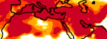
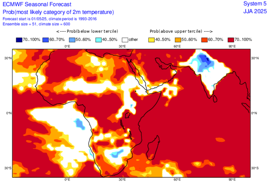
ECMWF JJA temperature forecast with emphasis to Sahara, the Middle East and Central Asia. Source: https://charts.ecmwf.int/products/seasonal_system5_standard_2mtm?area=GLOB&base_time=202504010000&stats=tsum&valid_time=202506020000
18. Dry anticyclonic anomaly above South-African countries
Hot days, but cold, temporarily freezing nights are possible in the region north of South Africa, with many cold temperature records in the region.
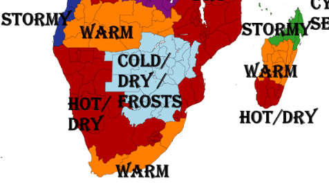
From our JJA 2025 forecast for Africa.
19. Volcanoes
Volcanoes in Andes should have a local, maximally regional effect on temperature or cloudiness in Africa in JJA 2025, in case of stronger eruptions, with higher VEI.
Similar or lesser effects of the possible very strong eruption across “The Ring of Fire” on the weather in Africa, especially through global temperature fluctuations.
Large volcanic eruptions inject aerosols into the stratosphere, cooling the surface and weakening African monsoons. In JJA 2025, this can cause cooler temperatures and reduced rainfall in the Sahel, East Africa, and Southern Africa, increasing drought risk.
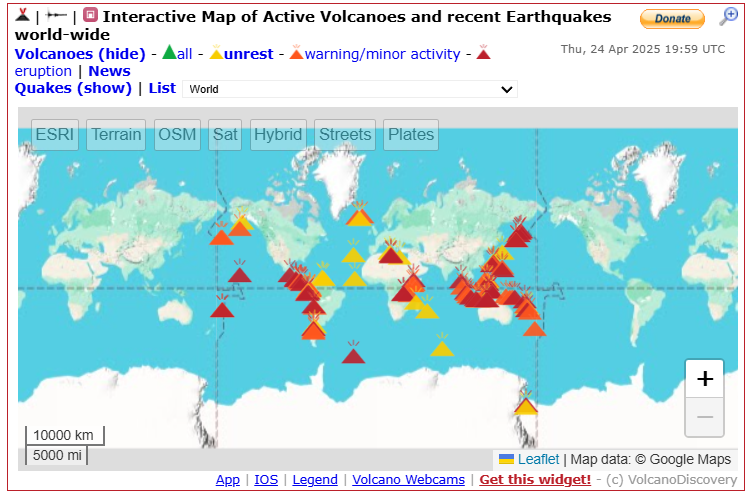
Current active volcanic zones. Source: https://ucweather.org/volcanorpt.php
Regional details


