Category 4 hurricane already on Tuesday above west Mexico, then California coast?
After hurricane Elida, 2. category (Wednesday, 12. August 2020) can west coast of Mexico and maybe California peninsula and California, too, hit a next powerful hurricane up to 4. category.
Wave of tropical downpours hit Mexico and parts of Central America according to Accuweather, too /https://www.accuweather.com/en/hurricane/tropical-downpours-target-mexico-central-america-as-east-pacific-awakens/795800/, altough, Accuweather did not predict so strong power of 12E TWELVE such as current (Sunday´s) forecasts.
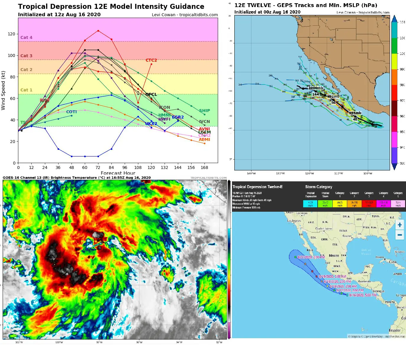
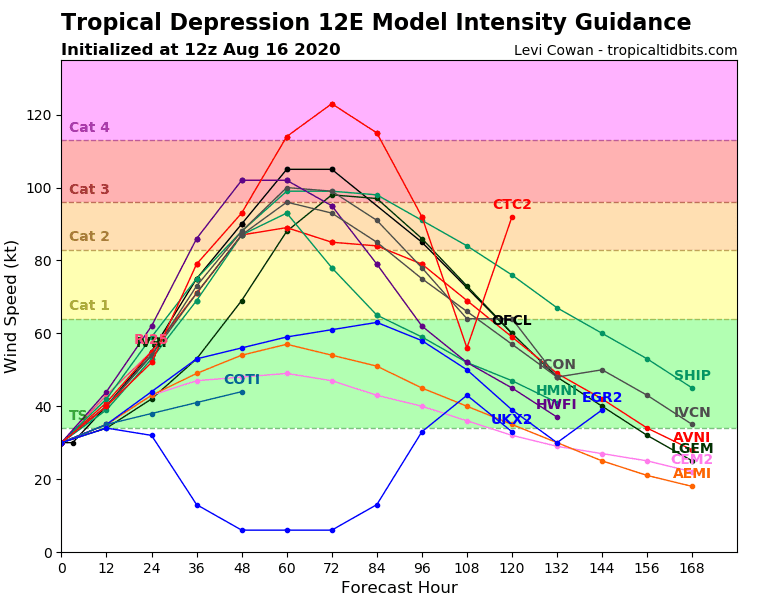
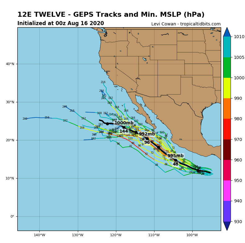
Tropical storm 12E TWELVE will quickly develop westerly from coast of Mexico during next 3 days to category 3-4 hurricane and move further with northwestward direction across coast of Mexico, Californian peninsula and according to few prognoses, SW California, too.
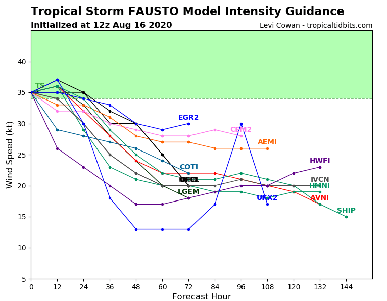
Last week, over North-American Pacific sector was develop several tropical depressions, besides 12E TWELVE e.g. tropical storm Fausto. However, Fausto is far from the coast of Mexico and it´s quick weakening from weaker tropical storm intensity.
12E twelve will send few rainfall and wind systems over west coast of Mexico and Baja California, but before potential arrival above California, it will be weakening.
Hurricane activity can be in mentioned areas linked with mudslides, heavy rain and strong winds, rough surf or dangerous seas.
Over continental parts of Mexico and western half of US an excessive heatwave is ongoing, therefore, Mexico will be during next days bothered with more weather phenomenas with orange to red alerts (heatwaves + fires; storms + wind + rain).
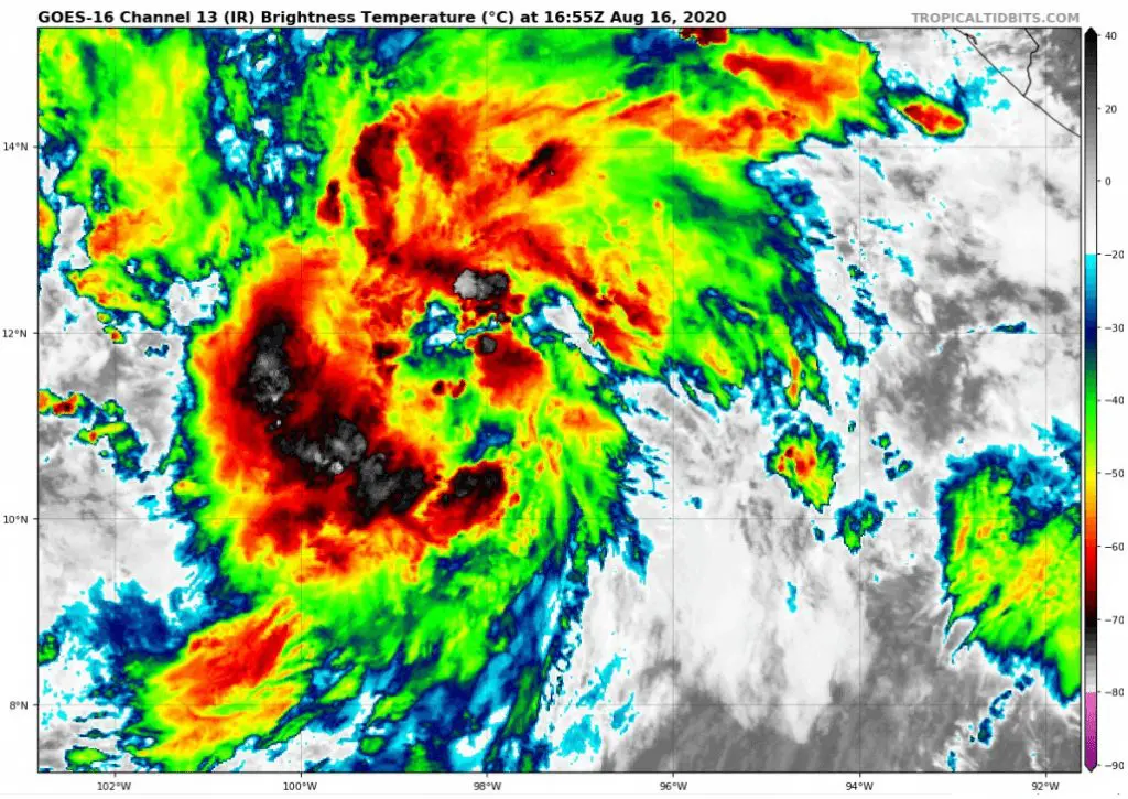
Documentation of 12E TWELVE from tropicaltidbits.com and wunderground.com:
Last report about next hurricane from NOAA:
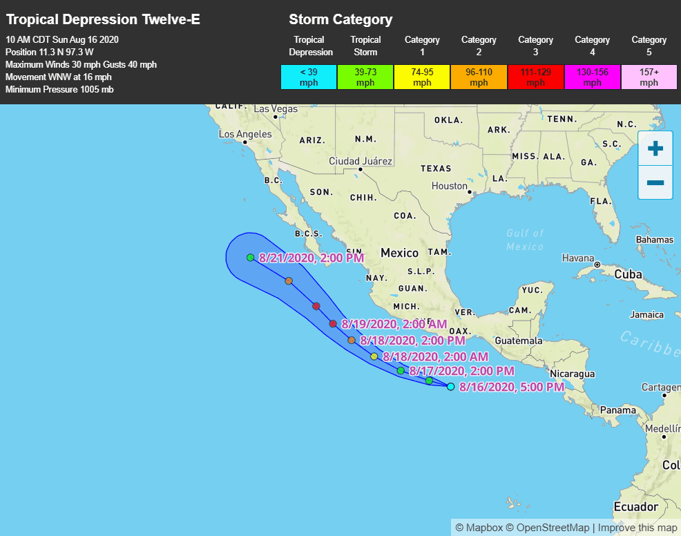
709
WTPZ32 KNHC 161444
TCPEP2

BULLETIN
Tropical Depression Twelve-E Advisory Number   1
NWS National Hurricane Center Miami FL       EP122020
1000 AM CDT Sun Aug 16 2020

...TROPICAL DEPRESSION FORMS SOUTH OF THE COAST OF MEXICO...
...EXPECTED TO STRENGTHEN RAPIDLY ON MONDAY WHILE REMAINING WELL
OFFSHORE THE COAST OF SOUTHERN MEXICO...


SUMMARY OF 1000 AM CDT...1500 UTC...INFORMATION
-----------------------------------------------
LOCATION...11.3N 97.3W
ABOUT 425 MI...680 KM SSE OF ACAPULCO MEXICO
ABOUT 525 MI...850 KM SE OF ZIHUATANEJO MEXICO
MAXIMUM SUSTAINED WINDS...35 MPH...55 KM/H
PRESENT MOVEMENT...WNW OR 285 DEGREES AT 18 MPH...30 KM/H
MINIMUM CENTRAL PRESSURE...1005 MB...29.68 INCHES


WATCHES AND WARNINGS
--------------------
There are no coastal watches or warnings in effect.


DISCUSSION AND OUTLOOK
----------------------
At 1000 AM CDT (1500 UTC), the center of Tropical Depression
Twelve-E was located near latitude 11.3 North, longitude 97.3 West.
The depression is moving toward the west-northwest near 18 mph (30
km/h).  A west-northwestward motion with some decrease in forward
speed is expected over the next few days.  On the forecast track,
the center of the depression is forecast to move parallel to but
well offshore of the coast of southern Mexico during the next
couple of days.

Maximum sustained winds are near 35 mph (55 km/h) with higher gusts.
Strengthening is expected today, and the depression is forecast to
become a tropical storm later today or tonight.  Rapid
strengthening is anticipated on Monday, and the system is forecast
to become a hurricane by Monday afternoon or Monday night.

The estimated minimum central pressure is 1005 mb (29.68 inches).


HAZARDS AFFECTING LAND
----------------------
SURF:  Swells generated by this system will begin affecting portions
of the southern coast of Mexico on Monday and Tuesday. These
swells are likely to cause life-threatening surf and rip current
conditions.  Please consult products from your local weather
office.


NEXT ADVISORY
-------------
Next complete advisory at 400 PM CDT.

$$
Forecaster Brown
Tropical storm Fausto (far and weak) according to tropicaltidbits.com: