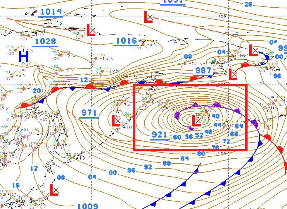
The most broken circulation on Earth in history: Aleutian low 921 hPa, equal to a Category 5 hurricane, deepest within all-time records
Only few hours ago, Mkweather informed about record high air pressure measured within Siberian high in all-time Earth´s history, 1094,3 hPa in Tsetsen Uul, Mongolia on 30. December 2020 /https://mkweather.com/2021/01/01/10943-hpa-mongolia-with-the-highest-measured-air-pressure-on-earth-in-history//.
But, it is not all story o broken circulation of these days – it appears, that the most broken circulation in history.
Only last hours, meteorologists around the world report next strange circulation pattern, and not so far from Eastern Asia – an extremely low air pressure above Aleutian low region, with a pressure low with measured 921 hPa, with forecasts expecting a pressure between 915 – 920 hPa.
This is the deepest extratropical cyclone in Earth ever, previous record has value 924 hPa from Dutch Harbour from Winter 2014/15.
According to professionals, we should watch on New Year a monstrous low pressure system, with air pressure at a level of a Category 5 hurricane.
Difference between both historic anomalies make 174,3 hPa, what should leave unprecedented feet on circulation around the globe during next days, weeks and months.
From Asia, above North America and Europe, both, will shift from the middle of extreme Siberian high during next 2-3 weeks extremely cold air, with result of peak of Winter 2020/2021 in the middle of season, with next possible historic cold temperatures /https://mkweather.com/2021/01/01/peak-of-the-winter-in-europe-russia-and-scandinavia-50c-continental-europe-30c-and-british-islands-20c/; https://mkweather.com/2020/12/28/oymyakon-lowest-temperature-since-2002-572c-in-monstrous-pressure-high-1076-hpa/; https://mkweather.com/2020/12/29/siberian-blocking-extreme-cold-air-in-norway-433c-finland-411c-only-week-after-all-time-december-scandinavian-record-18c/; https://mkweather.com/2020/12/29/updated-ecmwf-6-week-forecast-for-the-world-absolute-peak-of-the-winter-2020-21-in-continental-europe-around-15-january-after-decline-of-naoi-below-2-aoi-below-4//.
After peak of Winter 2020/2021, shortly after decline of AO and NAO indices below -4 / -2 in the middle of January 2021, a strong reaction of circulation in form of early spring conditions is forecasted /https://mkweather.com/2020/12/29/in-2021-spring-come-earlier//.
It appears, that climate change has reached a new level of development after 2020 and mega-blocking circulation such now will be in the future more and more often. It means – more cold temperature records in mid-latitudes and more circulation-associated extremes, with result of regional natural disasters such as floods, landslides, extreme blizzards or windstorms.


