Its already end of November 2020 and we should recapitulate, if late autumn coldwaves really have occurred in parts of Europe and Northern America and if next early winter coldwaves are prepared for early Winter in intentions of Mkweather Autumn 2020 and Winter 2020/2021 seasonal forecasts /AUTUMN AUGUST; WINTER JULY; WINTER SEPTEMBER/.
Then, we should compare, if forecast for Christmas 2020 has changed /CHRISTMAS/, or not and if it fits with our new Winter Final Outlook.
But what is the most important, Mkweather has processed the new, Final Outlook for Winter 2020/2021, with the newest outputs and new findings what weather we should expect during incoming winter in Europe and North America (and according to maps in World, too, predictions for Wolrd according to ENSO for Winter 2020/2021 and Summer 2021 you should find here: WINTER SUMMER NOVEMBER).
October with historic coldwave in the USA, in November and December next early coldwaves
Mkweather forecast associated with predicted early autumn and winter cold blasts in Northern Hemisphere appears successful – there are some examples of its validity (note (!): temperature anomaly near meandering jet-stream and anomalous Rossby waves not means that near warm weather shouldn´t be increased frequency of severe cold Arctic spells):
- Historic the coldest October temperature in the USA for last more than 200 years in October 2020 during the long-term lasting coldwaves /OCTOBER RECORD; ARCTIC DAYS IN OCTOBER/: -33°C / -29.2°F in Potomac, Montana.
- NAO- / AO- October with rainy / cloudy weather with many coldwaves in Europe /many articles in Mkweather Archive from October/
- current coldwaves in China /CHINA NOVEMBER/, parts of the USA /USA/ and Europe /EUROPE/
- Canada under the snow /CANADA/
- forecasted conditions for December 2020 and Christmas /CHRISTMAS 2020/
- hundreds of articles of Mkweather about circulation conditions and cold spells during Autumn 2020 in Archive /ARCHIVE/
Warm winter in USA, except for northern states
Untraditionally, we will start with the USA and Canada, because expected weather patterns and their effect to temperatures (and precipitation) in the region are unequivocal – with different weather patterns and character of winter in the USA and in Canada.
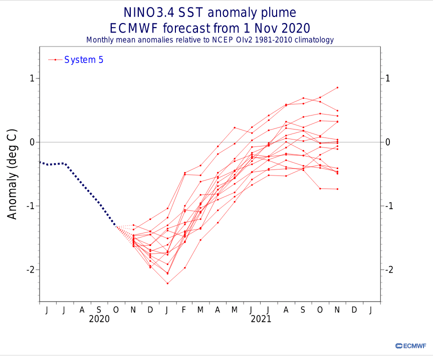
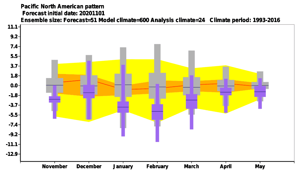
Thanks to La-nina a negative phases of PNA and NPD its relatively clear, that USA – mainly southern and central latitudinal parts, are waiting very warm and dry Winter 2020/2021.
Effects La-nina to weather patterns in USA are generally known – not only warm and dry South, but too rainy and snowy Northwest, North, Northern Plains, with cold blasts in Great Lakes region and Midwest during favorable circulation.
Negative PNA pattern is bringing positive pressure anomalies above E / S USA, Alaska, Kamchatka, Japan, CTRL Europe, Baltic (positive PNA phase reversely) and negative pressure anomalies above Canada, S Greenland, Iceland, GW hole area, what means, that air often flows in this circulation from south to the north over southern and eastern USA.
Negative NPD pattern is bringing high pressure anomalies above England, Ireland, France, Spain, between British Island and Azores, CTRL/E Canada, Northern Plains, Midwest, Northeast, Korea, Japan, Hawaii high Pacific region and low pressure anomalies above Alaska, Far East, Greenalnd, W coast of North America (positive NPD reversely), what has similar effect to temperatures in Northern Plains, Midwest and Northeast such as negative PNA, with southern flow components.
Very cold and snowy Canada, Alaska, Greenland and northern USA
La nina, PNA, NPD, but too NAO and EAT have signigicant effects to winter weather in Canada.
At all, cold and very snowy winter is expected in Canada, mainly in its western and central parts, with a lot of cold Arctic blasts in persisting masses of Artic air.
This weather will be reaching over northern parts of the USA or Midwest, alternatively and cold conditions are expected in Alaska and Greenland sectors, too.
Main drivers will be La-nina with PNA and NPD, what is described in part about USA above – low geopotential (pressure) above Canada associated with ENSO-, PNA- and NPD- phases will cause, that cold Arctic air will be flowing from north towards to centers these cyclones, with many blizzards and often possibility of extreme frosts.
Europe – colder western, very warm eastern Europe, early coldwaves in December 2020 and atmospheric blocking in February 2021
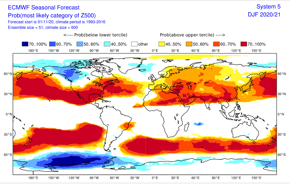
Finally, we should look at Winter 2020/2021 conditions in Europe. According to ECMFW maps (temperature anomaly is almost everywhere positive thanks to climate change), we should notice neutral temperature anomalies during incoming winter in western parts of Europe, but very warm conditions in eastern parts of the continent.
Negative / neutral temperature anomalies in western Europe will have several causes: it should be linked with a global change and Arctic Amplification, mainly Global Warming Hole anomaly over Northern Atlantic /GW HOLE 1; GW HOLE 2/, or extreme Atlantic hurricane season 2020 (linked with La-nina), but own roles will play main European circulation patterns, too.
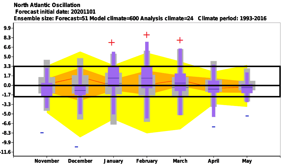
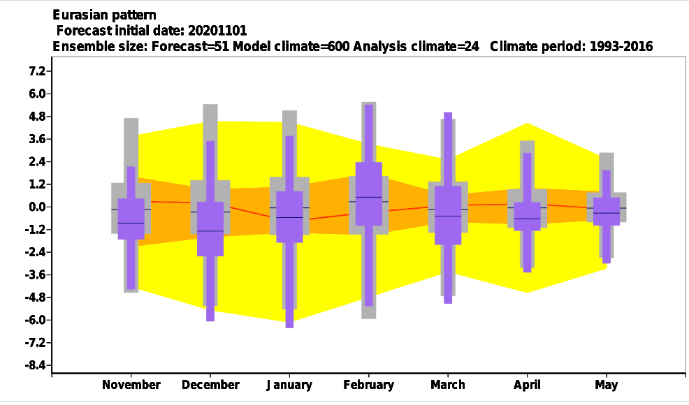
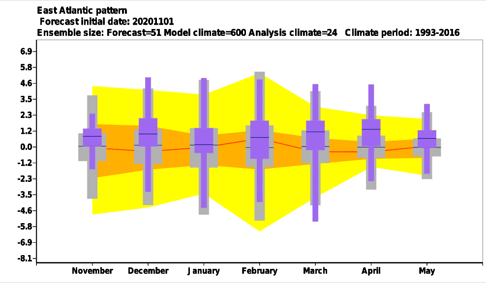
Mainly EAS and EAT apears for minimally 2 of 3 months favorable for cold winter in western parts of Europe, while (weaker) NAO- phase should bring cold conditions mainly in December, while in January and Ferbruary is for now strong NAO+ expected.
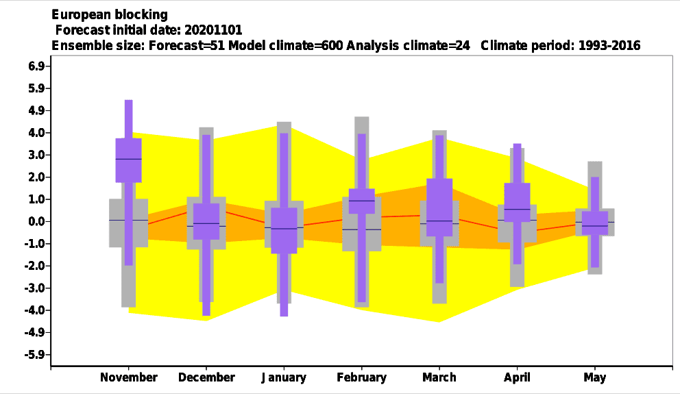
In December, all circulation modes (NAO, EAS and EAT) are more favorable than unfavorable for early winter Arctic cold blasts, January appears with severe coldwaves mainly in Eastern Europe and Scandinavia (EAS- expected, but NAO+ and EAT+) and finally, during February should surprised wild card – blocking patterns, with late winter Arctic cold blast, however, near NAO+.
Blue words above are describing only chosen regions with possiblity of coldwaves in Europe during incoming winter – January and February 2021 should be thanks to strong NAO+ phase in many parts of Europe very warm!
Christmas forecast – still cold in Europe until the Christmas, then warm New Year and start of 2021, will come SSW then?
According to 32-day ECMWF forecast for Prague, declining trend of temperature is still forecasted fore next 32 days – until 26. December, but for Exeter, UK, start of warmer weather is forecasted around Christmas 2020, what should mean, that at the end of the year 2020 and in early January 2021 we should go trough strong positive AO / NAO phase (AO+/NAO+).
This behavior, with strengthening of AO and NAO in the middle of winter is often associated with subsequent possibility of Sudden Stratospheric Warming – it means, strong decline of AO and NAO with peak of winter in mid-latitudes with extreme frosts in Europe, North America and Asia.
We will see, if SSW we will be experienced with already during the second half of January, or later, in February 2021, if ever. It was found, that more than 70% of La nina years have brought SSW, therefore, probability of a big return of extremely cold conditions, for a time, here will be in the second half of Winter 2020/2021, too.


Very simplified scheme of character of Winter 2020/2021 in Northern America and Europe:


Expected temperature, precipitation and geopotential (pressure) anomalies in the World for Winter 2020/2021 /ECMWF:


Expected evolution of climatic indices during next months /ECMWF:

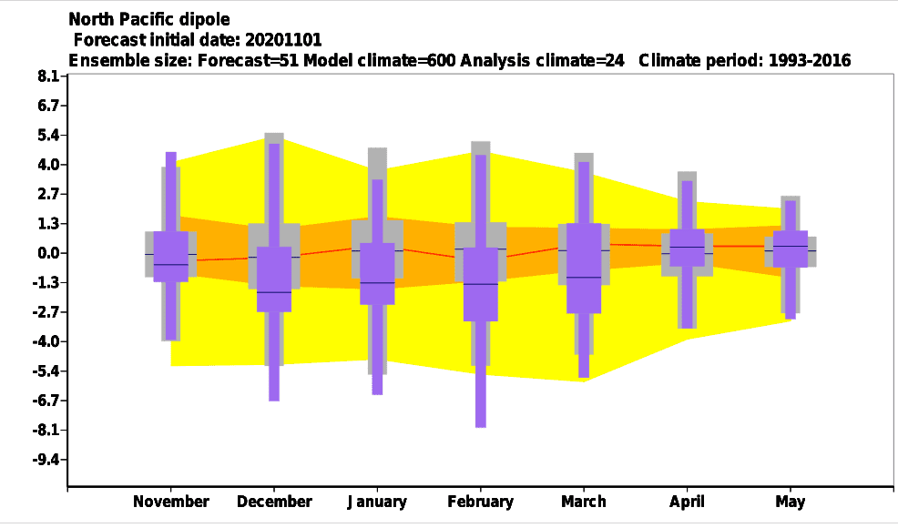
32-day forecast for chosen 2 European cities /ECMWF:


MJO 40-day forecast /NOAA:
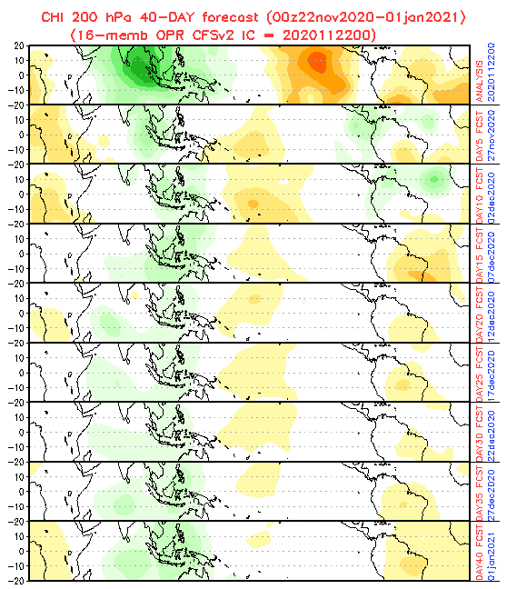
QBO current status – expected transition from warm westerly to cold easterly phase / NASA:

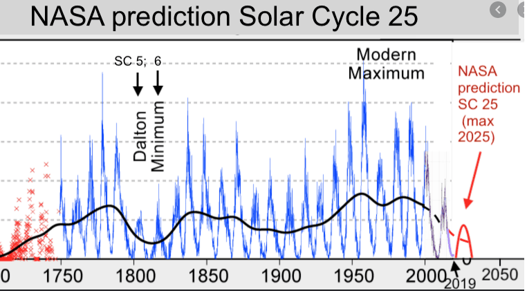
Solar cycle forecast for next years /NASA:
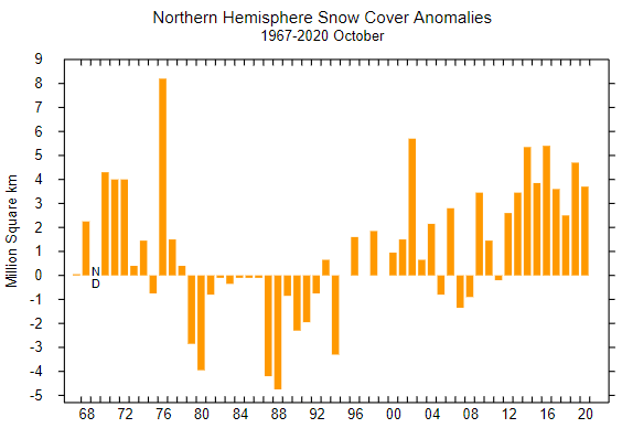
October snow cover anomaly in Northern Hemisphere and 23. November daily anomalies – map /climate.rutgers.edu:

Global warming hole forecast /ECMWF:

Record-melting Arctic in Autumn 2020 /NSIDC:






















5 thoughts on “*WINTER FORECAST 2020/2021* – FINAL OUTLOOK”