Before an arrival of waving cold front to the Central Europe, extremely warm weather is peaking in continental Europe.
After summer temperatures in France (Biarritz, +27,8°C) on Sunday, 1. November, almost summer weather hit Germany – Offenbach is reporting +22,7°C in Monday´s afternoon and temperature is still rising.
It is very possible, that in southwestern Germany will be Monday´s maximum temperature rarely around +24/+25°C /https://mkweather.com/2020/11/01/25c-in-germany-after-frances-278c-in-november//.
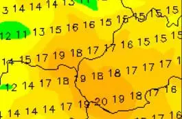
This air mass will shift until Tuesday, 3. November above East-Central Europe, where +23/+24°C in Hungary, +23°C in Slovakia, +22°C in Austria and Czechia and +20/+21°C in Poland is regionally possible.
Temperatures in region only very rarely reaches more than +25,0°C – mainly in Hungary and Austria. In Slovakia, the first +25°C in November has been measured in November 2018 in lowlands during extreme sunny autumn.
Daily temperatures in region in this season are very dependent from creation of fogs and low cloudiness and therefore winds and sunshine, too.
Often must meet more factors to ideal conditions for warming up of lower atmosphere levels:
1. Dry air
2. Fresh winds (ideally foehn winds)
3. Less cloudiness and all-day sunshine
4. Warm air in 850 hPa
5. Any or very short duration of fogs
In regions, where will occur on Tuesday conditions such these, it is possible, that early November 2020 brings record high temperatures. In regions with fogs and weaker winds, it can be 10-15°C colder rarely (mainly barrier basins and valleys).
Infographics: wetterzentrale.de, CHMI


