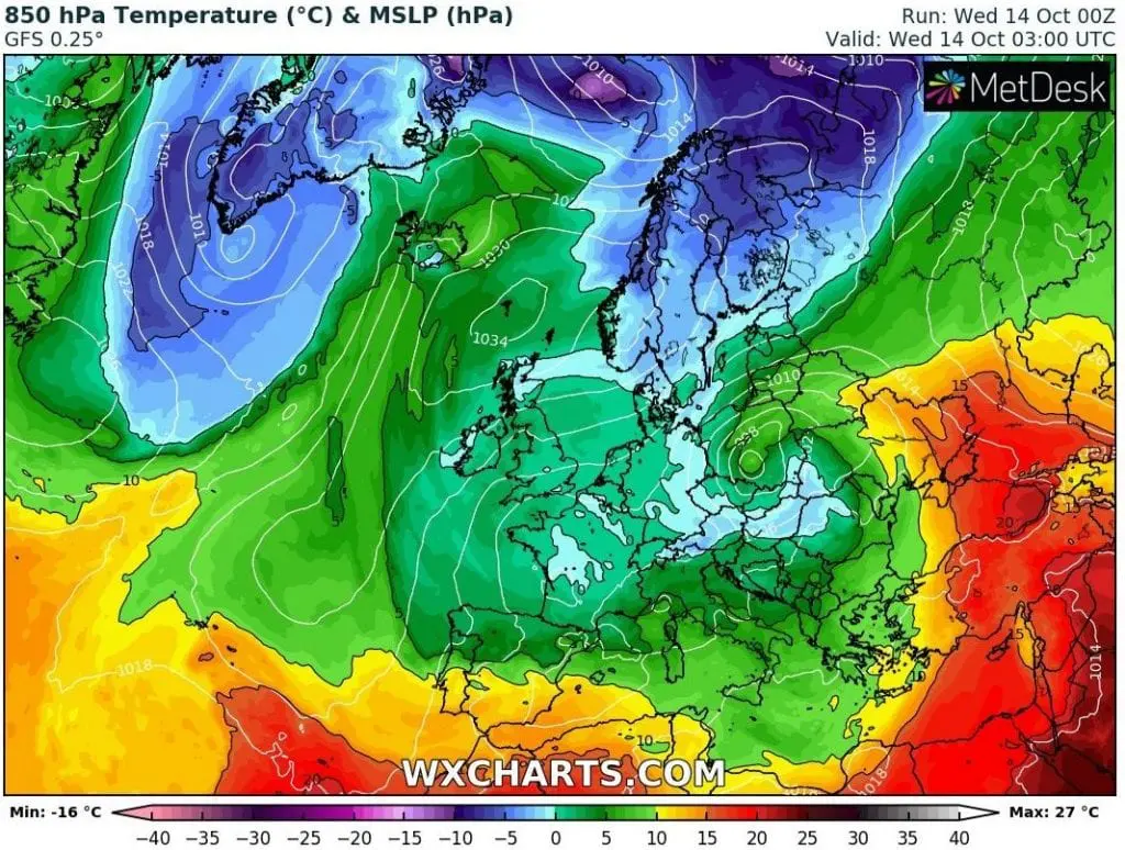
Norway -9,6°C, Finland -6,1°C, Sweden -6,0°C, Germany -4,4°C, Slovenia -2,9°C, Austria -1,5°C, Italy -1,2°C…Europe hit severe frosts on Wednesday, 14. October

Expected frosts has come earlier and in strong intensity and on larger area in Europe. In previous articles we warned about extreme coldwave, with heavy rain, severe winds and then, frosts and regional snowing, in Europe (e.g. https://mkweather.com/2020/10/12/widespread-frosts-in-germany-austria-slovakia-and-czechia-expected-at-the-weekend-and-early-next-week/; https://mkweather.com/2020/10/11/twice-long-coldwave-in-europe-not-10-but-20-days-of-cold-weather-all-16-days-of-gfs-model-are-cold/)
Round of floods hit Italy, Balkan and Central Europe last 72 hours (Monday-Wednesday, 12.-14. October) – firstly Mediterranean storm system, then its remnans in Central Europe (in Wednesday evening, Slovakia and Czechia still with 3rd level warnings before floods on meteoalarm.eu) /https://mkweather.com/2020/10/12/mediterranean-system-floods-winds-and-tornadoes-in-italy-montenegro-greece-austria-bosnia-and-croatia-on-monday/; https://mkweather.com/2020/10/12/warsaw-92c-zagreb-90c-munich-and-brno-88c-vienna-84c-and-bratislava-only-70c-in-austria-under-1000-masl-winter-24c-extreme-cold-weather-in-europe//.
In basins in Alps, Carpathians or NW Balkan mountains has been snowing from Monday to Wednesday from 500 – 1000, in Slovakia regionally from 300 MASL /https://mkweather.com/2020/10/13/first-snow-of-winter-season-2020-21-in-slovakia//.
On the back side of Mediterranean – Central European deep low pressure system and the next deep cyclone above Northern Europe, has flown over the continent extremely cold Arctic air, with origin in Greenland high sector /circulation conditions of the first half of Autumn 2020 we are describing here: https://mkweather.com/2020/10/11/atmospheric-circulation-in-northern-hemisphere-europa-and-north-america-during-the-first-half-of-autumn-2020// and already on Tuesday has appeared above many parts of Europe the first frosts /https://mkweather.com/2020/10/13/slovenia-36c-austria-21c-france-20c-poland-13c-uk-08c-bosnia-04c-germany-03c-frosts-in-europe-under-1000-masl-last-24-hours//.
On Wednesday, frosts were even stronger – from Norway to Italy has been regions under 1000 MASL with minimum temperatures from 0°C to -10°C!
The coldest was in European Oymyakon, village Folldal-Fredheim in Norway (694 MASL), only -9,6°C (14.7°F). Utsjoki Nuargam in Finland has reported -6,1°C and Tarfala in Sweden -6,0°C.
Extremely cold was in Oberstdorf, Germany (810 MASL), only -4,4°C! From the next moderate-zone countries were frosts in Slovenia (Ratece, -2,9°C, note: on Tuesday -3,6°C, 864 MASL), in Austria (Innsbruck, -1,5°C), Switzerland (Elm, -1,2°C), Italy (Tarvisio, -1,2°C, 777 MASL), Estonia (Narva, -0,6°C) and Slovakia (Telgárt, -0,1°C).
Very cold was too in Moldova (Belcy, 0,0°C), Bosnia and Herzegovina (Livno, 724 MASL, 0,0°C) or Belgium (Elseborn, 564 MASL, 0,2°C).
Deep low pressure above Central Europe has brought except of heavy rain, 30-80 mm, rarely above 100 mm, severe wind gusts to lowlands – in Poland has been measured 119 km/h, in the UK 102 km/h, in Germany and Norway 101 km/h, in Sweden 97 km/h, Denmark 96 km/h and Czechia 90 km/h wind gusts in lowlands.
Before us are the next cold days of ongoing coldwave, therefore stay safe and watch current weather news, analysis, warnings and forecasts with Mkweather.
Infographics: